Aagaard Glacier
| Aagaard Glacier | |
|---|---|
 Location of Foyn Coast on Antarctic Peninsula | |
 Location of Aagaard Glacier in Antarctica Show map of Antarctic Peninsula Aagaard Glacier (Antarctica) Show map of Antarctica | |
| Location |
Graham Land Antarctica |
| Coordinates | 66°46′S 64°31′W / 66.767°S 64.517°W / -66.767; -64.517Coordinates: 66°46′S 64°31′W / 66.767°S 64.517°W / -66.767; -64.517 |
| Length | 8 miles (13 km) |
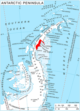
Aagaard Glacier (66°46′S 64°31′W / 66.767°S 64.517°W / -66.767; -64.517), also known as Glaciar Alderete, is an 8-mile (13 km) long Antarctic glacier which lies close to the east of Gould Glacier and flows in a southerly direction into Mill Inlet, on the east coast of Graham Land. It was charted by the Falkland Islands Dependencies Survey (FIDS) and photographed from the air by the Ronne Antarctic Research Expedition during December 1947; it was named by the FIDS for Bjarne Aagaard, a Norwegian authority on Antarctic whaling and exploration.[1]
See also
References
![]()
This article is issued from
Wikipedia.
The text is licensed under Creative Commons - Attribution - Sharealike.
Additional terms may apply for the media files.