Shackleton Glacier
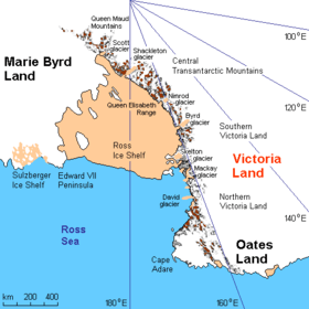
Shackleton Glacier is a major Antarctic glacier, over 96 km (60 mi) long and from 8 to 16 km (5 to 10 mi) wide, descending from the polar plateau from the vicinity of Roberts Massif and flowing north through the Queen Maud Mountains to enter the Ross Ice Shelf between Mount Speed and Waldron Spurs. The Roberts Massif is a remarkable snow-free massif exceeding 2,700 metres (8,860 ft) and about 155 km2 (60 sq mi) in area. It was visited by the Southern Party of New Zealand GSAE (1961–62), who named it for A.R. Roberts, leader at Scott Base for 1961-62.
The glacier was discovered by the USAS (1939–41) and named by US-SCAN for Sir Ernest Shackleton, Irish Antarctic explorer.
See also
References
- U.S. Geological Survey Geographic Names Information System: Shackleton Glacier
- U.S. Geological Survey Geographic Names Information System: Roberts Massif
Coordinates: 84°35′S 176°20′W / 84.583°S 176.333°W / -84.583; -176.333
| Types | |||||||
|---|---|---|---|---|---|---|---|
| Anatomy | |||||||
| Processes | |||||||
| Measurements | |||||||
| Volcanic relations | |||||||
| Landforms |
| ||||||
| |||||||