Pautalia Glacier
| Pautalia Glacier | |
|---|---|
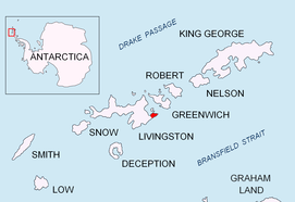 Location of Burgas Peninsulaon Livingston Island in the South Shetland Islands | |
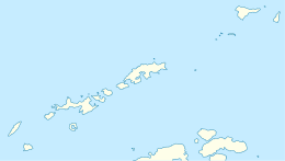 Location of Pautalia Glacier in Antarctica  Pautalia Glacier (Antarctica) | |
| Location |
Livingston Island South Shetland Islands |
| Coordinates | 62°37′41″S 59°51′50″W / 62.62806°S 59.86389°W |
| Length | 0.6 nautical miles (1.1 km; 0.69 mi) |
| Width | 0.4 nautical miles (0.74 km; 0.46 mi) |
| Thickness | unknown |
| Terminus | Bransfield Strait |
| Status | unknown |


Pautalia Glacier (Lednik Pautaliya \'led-nik pa-u-'ta-li-ya\) is a small glacier on Burgas Peninsula, Livingston Island in the South Shetland Islands, Antarctica situated northeast of Strandzha Glacier and south of Sopot Ice Piedmont. It is bounded by Petko Voyvoda Peak to the west, Sozopol Gap to the northwest, Kaloyan Nunatak to the north and Shabla Knoll to the east. The glacier extends 700 m in northwest-southeast direction and 1.1 km in southwest-northeast direction, and flows southeastward into Bransfield Strait.
The feature is named after the ancient Pautalia, ancestor of the present town of Kyustendil in Western Bulgaria.
Location
Pautalia Glacier is centred at 62°37′41″S 59°51′50″W / 62.62806°S 59.86389°WCoordinates: 62°37′41″S 59°51′50″W / 62.62806°S 59.86389°W. Bulgarian mapping in 2005 and 2009.
See also
Maps
- L.L. Ivanov et al. Antarctica: Livingston Island and Greenwich Island, South Shetland Islands. Scale 1:100000 topographic map. Sofia: Antarctic Place-names Commission of Bulgaria, 2005.
- L.L. Ivanov. Antarctica: Livingston Island and Greenwich, Robert, Snow and Smith Islands. Scale 1:120000 topographic map. Troyan: Manfred Wörner Foundation, 2009.
References
- This article includes information from the Antarctic Place-names Commission of Bulgaria which is used with permission.
External links
- Pautalia Glacier. SCAR Composite Gazetteer of Antarctica
- Bulgarian Antarctic Gazetteer. Antarctic Place-names Commission. (details in Bulgarian, basic data in English)