Darwin Glacier (Antarctica)
| Darwin Glacier | |
|---|---|
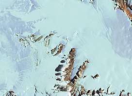 Satellite view of Antarctica showing part of Darwin Glacier | |
 Location of Darwin Glacier in Antarctica | |
| Location | Ross Dependency |
| Coordinates | 79°53′S 159°00′E / 79.883°S 159.000°E / -79.883; 159.000 |
| Thickness | unknown |
| Terminus | Ross Ice Shelf |
| Status | unknown |
Darwin Glacier (79°53′S 159°00′E / 79.883°S 159.000°E / -79.883; 159.000Coordinates: 79°53′S 159°00′E / 79.883°S 159.000°E / -79.883; 159.000) is a large glacier flowing from the polar plateau eastward between the Darwin Mountains and the Cook Mountains to the Ross Ice Shelf. The lower part of the glacier was mapped by the British National Antarctic Expedition, 1901–04, and the whole area traversed by New Zealand parties of the Commonwealth Trans-Antarctic Expedition (1956–58). The glacier was named in association with the Darwin Mountains (themselves named after Leonard Darwin).
Robertson Buttress is the westernmost in a series of large rock buttresses on the south side of Darwin Glacier between Alley Glacier and Gaussiran Glacier.
See also
References

| Types | |||||||
|---|---|---|---|---|---|---|---|
| Anatomy | |||||||
| Processes | |||||||
| Measurements | |||||||
| Volcanic relations | |||||||
| Landforms |
| ||||||
| |||||||
This article is issued from
Wikipedia.
The text is licensed under Creative Commons - Attribution - Sharealike.
Additional terms may apply for the media files.