Laroque-d'Olmes
| Laroque-d'Olmes | ||
|---|---|---|
| Commune | ||
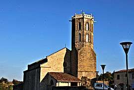 The church in Laroque-d'Olmes | ||
| ||
 Laroque-d'Olmes Location within Occitanie region  Laroque-d'Olmes | ||
| Coordinates: 42°58′16″N 1°52′22″E / 42.9711°N 1.8728°ECoordinates: 42°58′16″N 1°52′22″E / 42.9711°N 1.8728°E | ||
| Country | France | |
| Region | Occitanie | |
| Department | Ariège | |
| Arrondissement | Pamiers | |
| Canton | Mirepoix | |
| Intercommunality | Pays d'Olmes | |
| Government | ||
| • Mayor (2008–2014) | Christian Poma | |
| Area1 | 14.36 km2 (5.54 sq mi) | |
| Population (2008)2 | 2,712 | |
| • Density | 190/km2 (490/sq mi) | |
| Time zone | UTC+1 (CET) | |
| • Summer (DST) | UTC+2 (CEST) | |
| INSEE/Postal code | 09157 /09600 | |
| Elevation |
408–735 m (1,339–2,411 ft) (avg. 465 m or 1,526 ft) | |
| Website | https://www.facebook.com/randoxygene09 | |
|
1 French Land Register data, which excludes lakes, ponds, glaciers > 1 km2 (0.386 sq mi or 247 acres) and river estuaries. 2 Population without double counting: residents of multiple communes (e.g., students and military personnel) only counted once. | ||
.svg.png)
Laroque-d'Olmes is a commune in the Ariège department in southwestern France.
Population
| Historical population | ||
|---|---|---|
| Year | Pop. | ±% |
| 1900 | 4,217 | — |
| 1962 | 2,640 | −37.4% |
| 1968 | 2,894 | +9.6% |
| 1975 | 3,114 | +7.6% |
| 1982 | 3,124 | +0.3% |
| 1990 | 3,106 | −0.6% |
| 1999 | 2,657 | −14.5% |
| 2006 | 2,698 | +1.5% |
| 2008 | 2,712 | +0.5% |
See also
References
| Wikimedia Commons has media related to Laroque-d'Olmes. |
This article is issued from
Wikipedia.
The text is licensed under Creative Commons - Attribution - Sharealike.
Additional terms may apply for the media files.