Boykin, Kershaw County, South Carolina
| Boykin, South Carolina | |
|---|---|
| Census-designated place & Unincorporated community (CDP) | |
 Boykin, South Carolina  Boykin, South Carolina | |
| Coordinates: 34°07′01″N 80°34′53″W / 34.11694°N 80.58139°WCoordinates: 34°07′01″N 80°34′53″W / 34.11694°N 80.58139°W | |
| Country | United States |
| State | South Carolina |
| County | Kershaw |
| Area[1] | |
| • Total | 7.069 sq mi (18.31 km2) |
| • Land | 6.881 sq mi (17.82 km2) |
| • Water | 0.188 sq mi (0.49 km2) |
| Elevation | 164 ft (50 m) |
| Population (2010)[2] | |
| • Total | 100 |
| • Density | 14/sq mi (5.5/km2) |
| Time zone | UTC-5 (Eastern (EST)) |
| • Summer (DST) | UTC-4 (EDT) |
| Area code(s) | 803 |
| GNIS feature ID | 1246960[3] |
Boykin is a census-designated place and unincorporated community in Kershaw County, South Carolina, United States. Its population was 100 as of the 2010 census.[2] Boykin is located on South Carolina Highway 261, nine miles south of Camden. It is named for Lemuel Whitaker "Whit" Boykin, an early resident.
On May 5, 1860, at least two dozen individuals drowned in the Boykin Mill Pond when a flatboat they were enjoying an excursion on sank after it struck a stump, began taking on water and those onboard panicked and moved toward one end of the boat. It tipped, dumping the more than 50 people on the flatboat into the water.[4]
The Battle of Boykin's Mill was fought in Boykin on April 18, 1865. It marked the last battle of the American Civil War fought in South Carolina and was the site of the last Union officer killed in action during the conflict.[5] Boykin's Mill was added to the National Register of Historic Places in 1992.
South Carolina's state dog, the Boykin Spaniel, was originally bred in Boykin in the 1900s, after Whit Boykin experimented with crossbreeding, for which the dog is named after him. September 1 is Boykin Spaniel Day in South Carolina.
Every December, The Boykin Christmas Parade takes place in downtown Boykin.
Midfield Plantation was listed on the National Register of Historic Places in 1978.[6]
References
- ↑ "US Gazetteer files: 2010, 2000, and 1990". United States Census Bureau. 2011-02-12. Retrieved 2011-04-23.
- 1 2 "American FactFinder". United States Census Bureau. Archived from the original on 2013-09-11. Retrieved 2011-05-14.
- ↑ "Boykin". Geographic Names Information System. United States Geological Survey.
- ↑ "Remembering the Boykin Mill Pond Tragedy 150+ Years Later", Cotton Boll Conspiracy, March 2, 2016
- ↑ "Last Union Officer Killed in Civil War Shot by 14-Year-Old Boy", Cotton Boll Conspiracy, April 17, 2015
- ↑ National Park Service (2010-07-09). "National Register Information System". National Register of Historic Places. National Park Service.
Municipalities and communities of Kershaw County, South Carolina, United States | ||
|---|---|---|
| City | 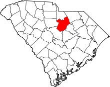 | |
| Towns | ||
| CDPs | ||
| Unincorporated communities | ||