South Carolina Highway 261
| ||||
|---|---|---|---|---|
 | ||||
| Route information | ||||
| Maintained by SCDOT | ||||
| Length | 116.95 mi[1] (188.21 km) | |||
| Existed | 1926 – present | |||
| Major junctions | ||||
| South end |
| |||
| North end |
| |||
| Location | ||||
| Counties | Georgetown, Williamsburg, Clarendon, Sumter, Kershaw | |||
| Highway system | ||||
| ||||

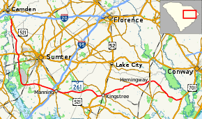
South Carolina Highway 261 (SC 261) is a state highway in the U.S. state of South Carolina. It runs 117 miles (188 km) between Yauhannah in Georgetown County to Kershaw County. Although the route covers more east–west distance, it is signed north–south.
Route description
SC 261 begins at U.S. Route 701 (US 701) at Yuhannah in Georgetown County. It travels westerly and then turns northward to end at US 521 north of Boykin in Kershaw County.[2]
Three U.S. National Historic Landmarks—the Millford Plantation, Borough House Plantation and Church of the Holy Cross—are located on the highway in the High Hills of Santee region of Sumter County.
Major Intersections
| County | Location | mi[1] | km | Destinations | Notes |
|---|---|---|---|---|---|
| Georgetown | Yuhannah | 0.00 | 0.00 | ||
| | 5.23 | 8.42 | Southern terminus of SC 513 | ||
| Williamsburg | Hemingway | 19.30 | 31.06 | ||
| Indiantown | 26.14 | 42.07 | South end of SC 512 overlap | ||
| | 28.59 | 46.01 | North end of SC 512 overlap | ||
| Kingstree | 42.85 | 68.96 | Northern terminus of SC 377 | ||
| 43.50 | 70.01 | South end of US 52 overlap | |||
| | 46.10 | 74.19 | North end of US 52 overlap | ||
| Clarendon | | 64.19 | 103.30 | South end of US 521 overlap | |
| Manning | 67.15 | 108.07 | North end of US 521 overlap | ||
| 67.24 | 108.21 | ||||
| 67.26 | 108.24 | Northern terminus of SC 260 | |||
| | 69.26– 69.46 | 111.46– 111.79 | Exit 119 (I-95) | ||
| Paxville | 76.38 | 122.92 | |||
| Sumter | Pinewood | 82.57 | 132.88 | Western terminus of SC 120 | |
| Wedgefield | 94.86 | 152.66 | Southern terminus of SC 763 | ||
| Stateburg | 98.78 | 158.97 | |||
| Kershaw | | 116.95 | 188.21 | ||
1.000 mi = 1.609 km; 1.000 km = 0.621 mi
| |||||
References
- 1 2 "Statewide Highways (shapefile)" (zip). South Carolina Department of Transportation. September 29, 2017. Retrieved December 8, 2017.
- ↑ Google (February 23, 2018). "South Carolina Highway 261" (Map). Google Maps. Google. Retrieved February 23, 2018.
External links
| Wikimedia Commons has media related to South Carolina Highway 261. |
Route map:
This article is issued from
Wikipedia.
The text is licensed under Creative Commons - Attribution - Sharealike.
Additional terms may apply for the media files.