Istanbul
| Istanbul İstanbul | |
|---|---|
| Metropolitan municipality | |
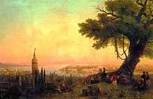
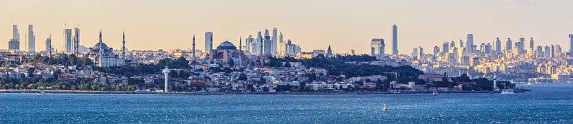
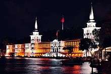
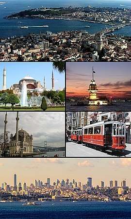 Clockwise from top: View of the Golden Horn between Karaköy and Sarayburnu within the historic areas; Maiden's Tower; a nostalgic tram on İstiklal Avenue; Levent business district with Dolmabahçe Palace; Ortaköy Mosque in front of the Bosphorus Bridge; and Hagia Sophia. | |
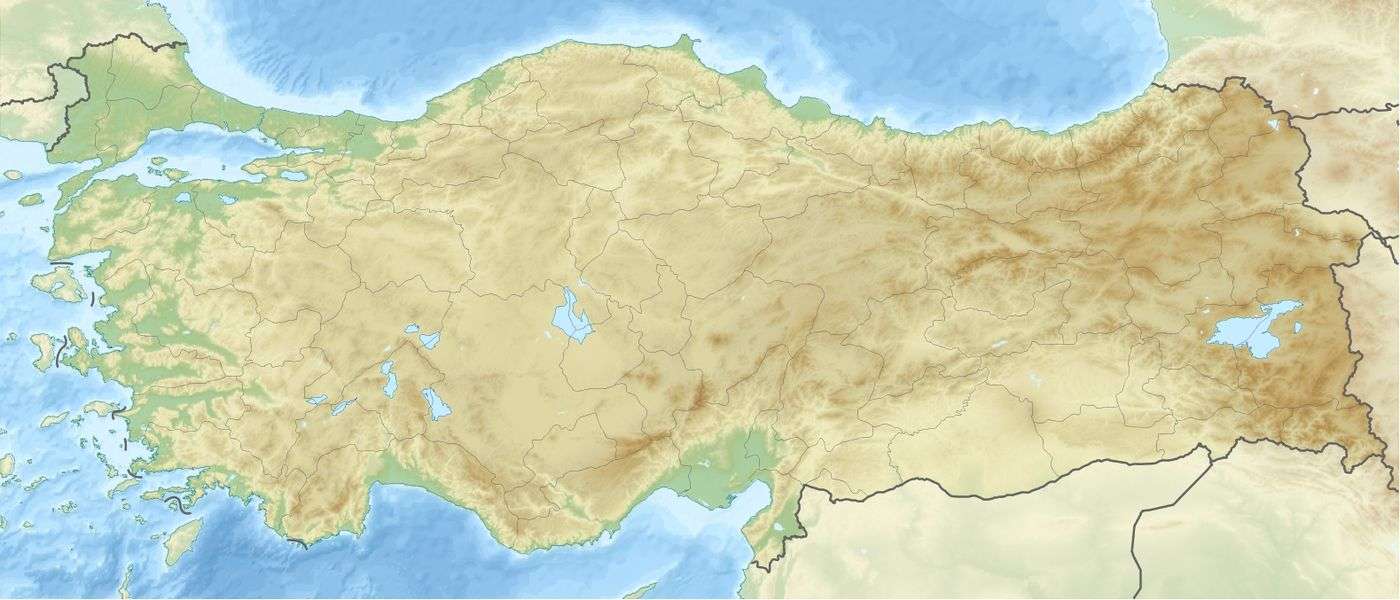 Istanbul Location of Istanbul in Turkey  Istanbul Istanbul (Europe)  Istanbul Istanbul (Asia) | |
| Coordinates: 41°00′49″N 28°57′18″E / 41.01361°N 28.95500°E | |
| Country |
|
| Region | Marmara |
| Province | Istanbul |
| Provincial seat[lower-alpha 1] | Cağaloğlu, Fatih |
| Districts | 39 |
| Government | |
| • Mayor | Mevlüt Uysal (AKP) |
| • Governor | Vasip Şahin |
| Area[1][2][lower-alpha 2] | |
| • Urban | 1,539 km2 (594 sq mi) |
| • Metro | 5,343 km2 (2,063 sq mi) |
| Elevation | 39 m (128 ft) |
| Population (31 December 2017)[3] | |
| • Metropolitan municipality | 15,029,231 |
| • Rank | 1st in Turkey |
| • Metro density | 2,813/km2 (7,290/sq mi) |
| Demonym(s) |
Istanbulite (Turkish: İstanbullu) |
| Time zone | UTC+3 (TRT) |
| Postal code | 34000 to 34990 |
| Area code(s) |
212 (European side) 216 (Asian side) |
| Vehicle registration | 34 |
| Nominal GDP | 2017 |
| - Total | US$349 billion[4] |
| - Per capita | US$23,221 |
| HDI (2015) | 0.788[5] – high |
| GeoTLD | .ist, .istanbul |
| Website |
ibb www |
| UNESCO World Heritage site | |
| Official name | Historic Areas of Istanbul |
| Criteria | Cultural: (i)(ii)(iii)(iv) |
| Reference | 356bis |
| Inscription | 1985 (9th Session) |
| Extensions | 2017 |
| Area | 765.5 ha (1,892 acres) |
Istanbul (UK: /ˌɪstænˈbʊl/, /-ˈbuːl/ or US: /-stɑːn-/ or /ˈɪstənbʊl/;[6][7][8] Turkish: İstanbul [isˈtanbuɫ] (![]()
Founded under the name of Byzantion (Βυζάντιον) on the Sarayburnu promontory around 660 BCE, the city grew in size and influence, having become one of the most important cities in history. After its reestablishment as Constantinople in 330 CE, it served as an imperial capital for almost 16 centuries, during the Roman/Byzantine (330–1204 and 1261–1453), the Latin (1204–1261), and the Ottoman (1453–1922) empires.[10] It was instrumental in the advancement of Christianity during Roman and Byzantine times, before the Ottomans conquered the city in 1453 CE and transformed it into an Islamic stronghold and the seat of the Ottoman Caliphate.[11]
Istanbul's strategic position on the historic Silk Road,[12] rail networks to Europe and the Middle East, and the only sea route between the Black Sea and the Mediterranean have produced a cosmopolitan populace. While Ankara was chosen instead as the new Turkish capital after the Turkish War of Independence, the city has maintained its prominence in geopolitical and cultural affairs. The population of the city has increased tenfold since the 1950s, as migrants from across Anatolia have moved in and city limits have expanded to accommodate them.[13][14] Arts, music, film, and cultural festivals were established towards the end of the 20th century and continue to be hosted by the city today. Infrastructure improvements have produced a complex transportation network in the city.
Approximately 12.56 million foreign visitors arrived in Istanbul in 2015, five years after it was named a European Capital of Culture, making the city the world's fifth most popular tourist destination.[15] The city's biggest attraction is its historic center, partially listed as a UNESCO World Heritage Site, and its cultural and entertainment hub can be found across the city's natural harbor, the Golden Horn, in the Beyoğlu district. Considered a global city,[16] Istanbul has one of the fastest-growing metropolitan economies in the world.[17] It hosts the headquarters of many Turkish companies and media outlets and accounts for more than a quarter of the country's gross domestic product.[18] Hoping to capitalize on its revitalization and rapid expansion, Istanbul has bid for the Summer Olympics five times in twenty years.[19]
Toponymy
The first known name of the city is Byzantium (Greek: Βυζάντιον, Byzántion), the name given to it at its foundation by Megarean colonists around 660 BCE.[20] The name is thought to be derived from a personal name, Byzas. Ancient Greek tradition refers to a legendary king of that name as the leader of the Greek colonists. Modern scholars have also hypothesized that the name of Byzas was of local Thracian or Illyrian origin and hence predated the Megarean settlement.[21]
After Constantine the Great made it the new eastern capital of the Roman Empire in 330 CE, the city became widely known as Constantinople, which, as the Latinized form of "Κωνσταντινούπολις" (Konstantinoúpolis), means the "City of Constantine".[20] He also attempted to promote the name "Nova Roma" and its Greek version "Νέα Ῥώμη" Nea Romē (New Rome), but this did not enter widespread usage.[22] Constantinople remained the most common name for the city in the West until the establishment of the Turkish Republic, and Kostantiniyye (Ottoman Turkish: قسطنطينيه) and Be Makam-e Qonstantiniyyah al-Mahmiyyah (meaning "the Protected Location of Constantinople") and İstanbul were the names used alternatively by the Ottomans during their rule.[23] The use of Constantinople to refer to the city during the Ottoman period (from the mid-15th century) is now considered politically incorrect, even if not historically inaccurate, by Turks.[24]
By the 19th century, the city had acquired other names used by either foreigners or Turks. Europeans used Constantinople to refer to the whole of the city, but used the name Stamboul—as the Turks also did—to describe the walled peninsula between the Golden Horn and the Sea of Marmara.[24] Pera (from the Greek word for "across") was used to describe the area between the Golden Horn and the Bosphorus, but Turks also used the name Beyoğlu (today the official name for one of the city's constituent districts).[25] Islambol (meaning either "City of Islam" or "Full of Islam") was sometimes colloquially used to refer to the city, and was even engraved on some Ottoman coins,[26] but the belief that it was the precursor to the present name, İstanbul, is belied by the fact that the latter existed well before the former and even predates the Ottoman conquest of the city.[20]
The name İstanbul (Turkish pronunciation: [isˈtanbuɫ] (![]()
In modern Turkish, the name is written as İstanbul, with a dotted İ, as the Turkish alphabet distinguishes between a dotted and dotless I. In English the stress is on the first or last syllable, but in Turkish it is on the second syllable (tan).[32] A person from the city is an İstanbullu (plural: İstanbullular), although Istanbulite is used in English.[33]
History
Neolithic artifacts, uncovered by archeologists at the beginning of the 21st century, indicate that Istanbul's historic peninsula was settled as far back as the 6th millennium BCE.[34] That early settlement, important in the spread of the Neolithic Revolution from the Near East to Europe, lasted for almost a millennium before being inundated by rising water levels.[35][36][37][38] The first human settlement on the Asian side, the Fikirtepe mound, is from the Copper Age period, with artifacts dating from 5500 to 3500 BCE,[39] On the European side, near the point of the peninsula (Sarayburnu), there was a Thracian settlement during the early 1st millennium BCE. Modern authors have linked it to the Thracian toponym Lygos,[40] mentioned by Pliny the Elder as an earlier name for the site of Byzantium.[41]
The history of the city proper begins around 660 BCE,[42][lower-alpha 3] when Greek settlers from Megara established Byzantium on the European side of the Bosphorus. The settlers built an acropolis adjacent to the Golden Horn on the site of the early Thracian settlements, fueling the nascent city's economy.[48] The city experienced a brief period of Persian rule at the turn of the 5th century BCE, but the Greeks recaptured it during the Greco-Persian Wars.[49] Byzantium then continued as part of the Athenian League and its successor, the Second Athenian League, before gaining independence in 355 BCE.[50] Long allied with the Romans, Byzantium officially became a part of the Roman Empire in 73 CE.[51] Byzantium's decision to side with the Roman usurper Pescennius Niger against Emperor Septimius Severus cost it dearly; by the time it surrendered at the end of 195 CE, two years of siege had left the city devastated.[52] Five years later, Severus began to rebuild Byzantium, and the city regained—and, by some accounts, surpassed—its previous prosperity.[53]
Rise and fall of Constantinople and the Byzantine Empire
_by_Florentine_cartographer_Cristoforo_Buondelmonte.jpg)
Constantine the Great effectively became the emperor of the whole of the Roman Empire in September 324.[54] Two months later, he laid out the plans for a new, Christian city to replace Byzantium. As the eastern capital of the empire, the city was named Nova Roma; most called it Constantinople, a name that persisted into the 20th century.[55] On 11 May 330, Constantinople was proclaimed the capital of the Roman Empire, which was later permanently divided between the two sons of Theodosius I upon his death on 17 January 395, when the city became the capital of the Eastern Roman (Byzantine) Empire.[56]
The establishment of Constantinople served as one of Constantine's most lasting accomplishments, shifting Roman power eastward as the city became a center of Greek culture and Christianity.[56][57] Numerous churches were built across the city, including the Hagia Sophia which was built during the reign of Justinian the Great and remained the world's largest cathedral for a thousand years.[58] Constantine also undertook a major renovation and expansion of the Hippodrome of Constantinople; accommodating tens of thousands of spectators, the hippodrome became central to civic life and, in the 5th and 6th centuries, the epicenter of episodes of unrest, including the Nika riots.[59][60] Constantinople's location also ensured its existence would stand the test of time; for many centuries, its walls and seafront protected Europe against invaders from the east and the advance of Islam.[57] During most of the Middle Ages, the latter part of the Byzantine era, Constantinople was the largest and wealthiest city on the European continent and at times the largest in the world.[61][62]
Constantinople began to decline continuously after the end of the reign of Basil II in 1025. The final blow was given by the conquest of Villardouin and Enrico Dandolo in 1204 during the Fourth Crusade, where the City was sacked and pillaged.[63] The city subsequently became the center of the Latin Empire, created by Catholic crusaders to replace the Orthodox Byzantine Empire.[64] Hagia Sophia was converted to a Catholic church in 1204. The Byzantine Empire was restored, albeit weakened, in 1261.[65] Constantinople's churches, defenses, and basic services were in disrepair,[66] and its population had dwindled to a hundred thousand from half a million during the 8th century.[lower-alpha 4] After the reconquest of 1261, however some of the city's monuments were restored, and some, like the two Deisis mosaics in Hagia Sofia and Kariye, were created.
Various economic and military policies instituted by Andronikos II, such as the reduction of military forces, weakened the empire and left it vulnerable to attack.[67] In the mid-14th-century, the Ottoman Turks began a strategy of gradually taking smaller towns and cities, cutting off Constantinople's supply routes and strangling it slowly.[68] On 29 May 1453, after an eight-week siege (during which the last Roman emperor, Constantine XI, was killed), Sultan Mehmed II "the Conqueror" captured Constantinople and declared it the new capital of the Ottoman Empire. Hours later, the sultan rode to the Hagia Sophia and summoned an imam to proclaim the Islamic creed, converting the grand cathedral into an imperial mosque due to the city's refusal to surrender peacefully.[69] Mehmed declared himself as the new "Kaysar-i Rûm" (the Ottoman Turkish equivalent of Caesar of Rome) and the Ottoman state was reorganized into an empire.[70]
Ottoman Empire and Turkish Republic eras
Following the conquest of Constantinople, Mehmed II immediately set out to revitalize the city, by then also known as Istanbul. He urged the return of those who had fled the city during the siege, and resettled Muslims, Jews, and Christians from other parts of Anatolia. He demanded that five thousand households needed to be transferred to Constantinople by September.[71] From all over the Islamic empire, prisoners of war and deported people were sent to the city: these people were called "Sürgün" in Turkish (Greek: σουργούνιδες).[72] However, many people escaped again from the city, and there were several outbreaks of plague, so that in 1459 Mehmet allowed the deported Greeks to come back to the city.[73] He also invited people from all over Europe to his capital, creating a cosmopolitan society that persisted through much of the Ottoman period.[74] Plague continued, however, to be essentially endemic in Istanbul for the rest of the century, as it had been from 1520, with a few years of respite between 1529 and 1533, 1549 and 1552, and from 1567 to 1570; epidemics originating in the West and in the Hejaz and southern Russia.[75] Population growth in Anatolia, however, allowed Istanbul to replace its losses and maintain its population of around 500,000 inhabitants down to 1800. Mehmed II also repaired the city's damaged infrastructure, including the whole water system, began to build the Grand Bazaar, and constructed Topkapı Palace, the sultan's official residence.[76] With the transfer of the capital from Edirne (formerly Adrianople) to Constantinople, the new state was declared as the successor and continuation of the Roman Empire.[77]
_and_view_of_Pera%2C_Constantinople%2C_Turkey%2C_ca._1895.jpg)
The Ottomans quickly transformed the city from a bastion of Christianity to a symbol of Islamic culture. Religious foundations were established to fund the construction of ornate imperial mosques, often adjoined by schools, hospitals, and public baths.[76] The Ottoman Dynasty claimed the status of caliphate in 1517, with Istanbul remaining the capital of this last caliphate for four centuries.[11] Suleiman the Magnificent's reign from 1520 to 1566 was a period of especially great artistic and architectural achievement; chief architect Mimar Sinan designed several iconic buildings in the city, while Ottoman arts of ceramics, stained glass, calligraphy, and miniature flourished.[78] The population of Istanbul was 570,000 by the end of the 18th century.[79]
A period of rebellion at the start of the 19th century led to the rise of the progressive Sultan Mahmud II and eventually to the Tanzimat period, which produced political reforms and allowed new technology to be introduced to the city.[80] Bridges across the Golden Horn were constructed during this period,[81] and Istanbul was connected to the rest of the European railway network in the 1880s.[82] Modern facilities, such as a water supply network, electricity, telephones, and trams, were gradually introduced to Istanbul over the following decades, although later than to other European cities.[83] The modernization efforts were not enough to forestall the decline of the Ottoman Empire.
Sultan Abdul Hamid II was deposed with the Young Turk Revolution in 1908 and the Ottoman Parliament, closed since 14 February 1878, was reopened 30 years later on 23 July 1908, which marked the beginning of the Second Constitutional Era.[84] A series of wars in the early 20th century, such as the Italo-Turkish War (1911–1912) and the Balkan Wars (1912–1913), plagued the ailing empire's capital and resulted in the 1913 Ottoman coup d'état, which brought the regime of the Three Pashas.[85]

The Ottoman Empire joined World War I (1914–1918) on the side of the Central Powers and was ultimately defeated. The deportation of Armenian intellectuals on 24 April 1915 was among the major events which marked the start of the Armenian Genocide during WWI.[86] As a result of the war and the events in its aftermath, the city's Christian population declined from 450,000 to 240,000 between 1914 and 1927.[87] The Armistice of Mudros was signed on 30 October 1918 and the Allies occupied Constantinople on 13 November 1918. The Ottoman Parliament was dissolved by the Allies on 11 April 1920 and the Ottoman delegation led by Damat Ferid Pasha was forced to sign the Treaty of Sèvres on 10 August 1920.
Following the Turkish War of Independence (1919–1922), the Grand National Assembly of Turkey in Ankara abolished the Sultanate on 1 November 1922, and the last Ottoman Sultan, Mehmed VI, was declared persona non grata. Leaving aboard the British warship HMS Malaya on 17 November 1922, he went into exile and died in Sanremo, Italy, on 16 May 1926. The Treaty of Lausanne was signed on 24 July 1923, and the occupation of Constantinople ended with the departure of the last forces of the Allies from the city on 4 October 1923.[88] Turkish forces of the Ankara government, commanded by Şükrü Naili Pasha (3rd Corps), entered the city with a ceremony on 6 October 1923, which has been marked as the Liberation Day of Istanbul (Turkish: İstanbul'un Kurtuluşu) and is commemorated every year on its anniversary.[88] On 29 October 1923 the Grand National Assembly of Turkey declared the establishment of the Turkish Republic, with Ankara as its capital. Mustafa Kemal Atatürk became the Republic's first President.[89]
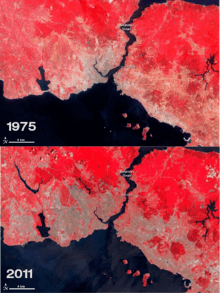
Ankara was selected as Turkey's capital in 1923 to distance the new, secular republic from its Ottoman history.[90] From the late 1940s and early 1950s, Istanbul underwent great structural change, as new public squares, boulevards, and avenues were constructed throughout the city, sometimes at the expense of historical buildings.[91] The population of Istanbul began to rapidly increase in the 1970s, as people from Anatolia migrated to the city to find employment in the many new factories that were built on the outskirts of the sprawling metropolis. This sudden, sharp rise in the city's population caused a large demand for housing, and many previously outlying villages and forests became engulfed into the metropolitan area of Istanbul.[92]

Geography
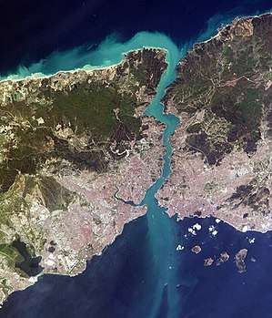

Istanbul is located in north-western Turkey within the Marmara Region on a total area of 5,343 square kilometers (2,063 sq mi).[lower-alpha 2] The Bosphorus, which connects the Sea of Marmara to the Black Sea, divides the city into a European, Thracian side—comprising the historic and economic centers—and an Asian, Anatolian side. The city is further divided by the Golden Horn, a natural harbor bounding the peninsula where the former Byzantium and Constantinople were founded. The confluence of the Sea of Marmara, the Bosphorus, and the Golden Horn at the heart of present-day Istanbul has deterred attacking forces for thousands of years and remains a prominent feature of the city's landscape.[57]
Following the model of Rome, the historic peninsula is said to be characterized by seven hills, each topped by imperial mosques. The easternmost of these hills is the site of Topkapı Palace on the Sarayburnu.[97] Rising from the opposite side of the Golden Horn is another, conical hill, where the modern Beyoğlu district is situated. Because of the topography, buildings in Beyoğlu were once constructed with the help of terraced retaining walls, and roads were laid out in the form of steps.[98] Üsküdar on the Asian side exhibits similarly hilly characteristics, with the terrain gradually extending down to the Bosphorus coast, but the landscape in Şemsipaşa and Ayazma is more abrupt, akin to a promontory. The highest point in Istanbul is Çamlıca Hill, with an altitude of 288 meters (945 ft).[98] The northern half of Istanbul has a higher mean elevation compared to the south coast, with locations surpassing 200 meters (660 ft), and some coasts with steep cliffs resembling fjords, especially around the northern end of the Bosphorus, where it opens up to the Black Sea.
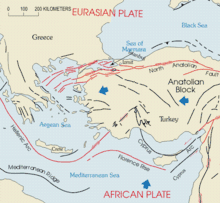
Istanbul is situated near the North Anatolian Fault, close to the boundary between the African and Eurasian Plates. This fault zone, which runs from northern Anatolia to the Sea of Marmara, has been responsible for several deadly earthquakes throughout the city's history. Among the most devastating of these seismic events was the 1509 earthquake, which caused a tsunami that broke over the walls of the city and killed more than 10,000 people. More recently, in 1999, an earthquake with its epicenter in nearby İzmit left 18,000 people dead, including 1,000 people in Istanbul's suburbs. The people of Istanbul remain concerned that an even more catastrophic seismic event may be in the city's near future, as thousands of structures recently built to accommodate Istanbul's rapidly increasing population may not have been constructed properly.[99] Seismologists say the risk of a 7.6-magnitude or greater earthquake striking Istanbul by 2030 is more than 60 percent.[100][101]
Climate

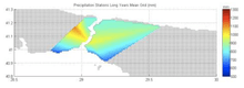
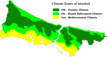
In the Köppen–Geiger classification system, Istanbul has a borderline Mediterranean climate (Csa), humid subtropical climate (Cfa) and oceanic climate (Cfb), due to its location in a transitional climatic zone. Since precipitation in summer months ranges from 20 to 65 mm (1 to 3 in), depending on location, the city cannot be classified as solely Mediterranean or humid subtropical.[102][103][104] Due to its size, diverse topography, maritime location and most importantly having a coastline to two different bodies of water to the north and south, Istanbul exhibits microclimates. The northern half of the city, as well as the Bosporus coastline, express characteristics of oceanic and humid subtropical climates, because of humidity from the Black Sea and the relatively high concentration of vegetation. The climate in the populated areas of the city to the south, located on the Sea of Marmara, is warmer, drier and less affected by humidity.[105] The annual precipitation in the northern half can be twice as much (Bahçeköy, 1166.6 mm), than it is in the southern, Marmara coast (Florya 635.0 mm).[106] There is a significant difference between annual mean temperatures on the north and south coasts as well, Bahçeköy 12.8 °C (55.0 °F), Kartal 15.03 °C (59.05 °F).[107] Parts of the province that are away from both seas exhibit considerable continental influences, with much more pronounced night-day and summer-winter temperature differences. In winter some parts of the province average freezing or below at night.
Istanbul's persistently high humidity reaches 80 percent most mornings.[108] Because of this, fog is very common, although more so in northern parts of the city and away from the city center.[105] Dense fog disrupts transportation in the region, including on the Bosphorus, and is common during the autumn and winter months when the humidity remains high into the afternoon.[109][110][111] The humid conditions and the fog tend to dissipate by midday during the summer months, but the lingering humidity exacerbates the moderately high summer temperatures.[108][112] During these summer months, high temperatures average around 29 °C (84 °F) and rainfall is uncommon; there are only about fifteen days with measurable precipitation between June and August.[113] The summer months also have the highest concentration of thunderstorms.[114]
Winter is colder in Istanbul than in most other cities around the Mediterranean Basin, with low temperatures averaging 1–4 °C (34–39 °F).[113] Lake-effect snow from the Black Sea is common, although difficult to forecast, with the potential to be heavy and—as with the fog—disruptive to the city's infrastructure.[115] Spring and autumn are mild, but often wet and unpredictable; chilly winds from the northwest and warm gusts from the south—sometimes in the same day—tend to cause fluctuations in temperature.[112][116] Overall, Istanbul has an annual average of 130 days with significant precipitation, which amounts to 810 millimeters (31.9 in) per year.[113][117] The highest and lowest temperatures ever recorded in the city center on the Marmara coast are 40.5 °C (105 °F) and −16.1 °C (3 °F). The greatest rainfall recorded in a day is 227 millimeters (8.9 in), and the highest recorded snow cover is 80 centimeters (31 in).[118][119]
| Climate data for Istanbul (Sarıyer), 1929–2017 | |||||||||||||
|---|---|---|---|---|---|---|---|---|---|---|---|---|---|
| Month | Jan | Feb | Mar | Apr | May | Jun | Jul | Aug | Sep | Oct | Nov | Dec | Year |
| Record high °C (°F) | 22.0 (71.6) |
24.7 (76.5) |
29.3 (84.7) |
33.6 (92.5) |
34.5 (94.1) |
40.2 (104.4) |
41.5 (106.7) |
40.5 (104.9) |
39.5 (103.1) |
34.2 (93.6) |
27.8 (82) |
25.5 (77.9) |
41.5 (106.7) |
| Average high °C (°F) | 8.4 (47.1) |
9.0 (48.2) |
10.9 (51.6) |
15.4 (59.7) |
20.0 (68) |
24.6 (76.3) |
26.6 (79.9) |
26.8 (80.2) |
23.7 (74.7) |
19.1 (66.4) |
14.8 (58.6) |
10.8 (51.4) |
17.5 (63.5) |
| Daily mean °C (°F) | 6.0 (42.8) |
6.1 (43) |
7.7 (45.9) |
12.0 (53.6) |
16.7 (62.1) |
21.4 (70.5) |
23.8 (74.8) |
23.8 (74.8) |
20.1 (68.2) |
15.7 (60.3) |
11.7 (53.1) |
8.3 (46.9) |
14.4 (57.9) |
| Average low °C (°F) | 3.1 (37.6) |
3.1 (37.6) |
4.2 (39.6) |
7.6 (45.7) |
12.1 (53.8) |
16.5 (61.7) |
19.4 (66.9) |
20.1 (68.2) |
16.8 (62.2) |
12.9 (55.2) |
8.9 (48) |
5.5 (41.9) |
10.8 (51.4) |
| Record low °C (°F) | −13.9 (7) |
−16.1 (3) |
−11.1 (12) |
−2.0 (28.4) |
1.4 (34.5) |
7.1 (44.8) |
10.5 (50.9) |
10.2 (50.4) |
6.0 (42.8) |
0.6 (33.1) |
−7.2 (19) |
−11.5 (11.3) |
−16.1 (3) |
| Average precipitation mm (inches) | 106.0 (4.173) |
77.7 (3.059) |
71.4 (2.811) |
45.9 (1.807) |
34.4 (1.354) |
36.0 (1.417) |
33.3 (1.311) |
39.9 (1.571) |
61.7 (2.429) |
88.0 (3.465) |
100.9 (3.972) |
122.2 (4.811) |
817.4 (32.181) |
| Average precipitation days (≥ 0.1 mm) | 17.3 | 15.2 | 13.8 | 10.3 | 8.0 | 6.2 | 4.3 | 5.0 | 7.6 | 11.2 | 13.0 | 17.1 | 129.0 |
| Mean monthly sunshine hours | 89.9 | 101.7 | 142.6 | 195.0 | 272.8 | 318.0 | 356.5 | 328.6 | 246.0 | 176.7 | 120.0 | 83.7 | 2,431.5 |
| Mean daily sunshine hours | 2.9 | 3.6 | 4.6 | 6.5 | 8.8 | 10.6 | 11.5 | 10.6 | 8.2 | 5.7 | 4.0 | 2.7 | 6.6 |
| Source: Turkish State Meteorological Service[120] | |||||||||||||
| Climate data for Istanbul (Kireçburnu, Sarıyer), 1949–1999 | |||||||||||||
|---|---|---|---|---|---|---|---|---|---|---|---|---|---|
| Month | Jan | Feb | Mar | Apr | May | Jun | Jul | Aug | Sep | Oct | Nov | Dec | Year |
| Average high °C (°F) | 8.3 (46.9) |
8.7 (47.7) |
10.3 (50.5) |
15.2 (59.4) |
19.6 (67.3) |
24.2 (75.6) |
26.0 (78.8) |
26.1 (79) |
23.3 (73.9) |
19.0 (66.2) |
14.8 (58.6) |
10.9 (51.6) |
17.2 (63) |
| Daily mean °C (°F) | 5.5 (41.9) |
5.5 (41.9) |
6.7 (44.1) |
10.9 (51.6) |
15.4 (59.7) |
20.1 (68.2) |
22.4 (72.3) |
22.6 (72.7) |
19.5 (67.1) |
15.5 (59.9) |
11.6 (52.9) |
8.1 (46.6) |
13.7 (56.6) |
| Average low °C (°F) | 3.0 (37.4) |
2.9 (37.2) |
4.0 (39.2) |
7.5 (45.5) |
11.9 (53.4) |
16.2 (61.2) |
19.1 (66.4) |
19.7 (67.5) |
16.6 (61.9) |
12.8 (55) |
8.9 (48) |
5.6 (42.1) |
10.7 (51.2) |
| Average precipitation mm (inches) | 103.6 (4.079) |
70.5 (2.776) |
71.0 (2.795) |
47.2 (1.858) |
45.8 (1.803) |
36.8 (1.449) |
35.6 (1.402) |
38.6 (1.52) |
51.9 (2.043) |
81.3 (3.201) |
100.8 (3.969) |
122.0 (4.803) |
805.1 (31.698) |
| Average snowy days (≥ 0.1 mm) | 3.6 | 4.9 | 2.8 | 0.0 | 0.0 | 0.0 | 0.0 | 0.0 | 0.0 | 0.0 | 0.3 | 1.5 | 13.1 |
| Source: Turkish State Meteorological Service[121] (1949–1999) | |||||||||||||
| Climate data for Istanbul (Bahçeköy, Sarıyer), 1949–1999 | |||||||||||||
|---|---|---|---|---|---|---|---|---|---|---|---|---|---|
| Month | Jan | Feb | Mar | Apr | May | Jun | Jul | Aug | Sep | Oct | Nov | Dec | Year |
| Average high °C (°F) | 8.0 (46.4) |
8.6 (47.5) |
10.5 (50.9) |
15.9 (60.6) |
20.6 (69.1) |
24.7 (76.5) |
26.3 (79.3) |
26.6 (79.9) |
23.7 (74.7) |
19.2 (66.6) |
14.7 (58.5) |
10.4 (50.7) |
17.4 (63.4) |
| Daily mean °C (°F) | 4.6 (40.3) |
4.7 (40.5) |
6.0 (42.8) |
10.5 (50.9) |
15.0 (59) |
19.3 (66.7) |
21.5 (70.7) |
21.6 (70.9) |
18.2 (64.8) |
14.1 (57.4) |
12.2 (54) |
6.8 (44.2) |
12.9 (55.2) |
| Average low °C (°F) | 1.7 (35.1) |
1.6 (34.9) |
2.8 (37) |
6.4 (43.5) |
10.7 (51.3) |
14.5 (58.1) |
17.0 (62.6) |
17.6 (63.7) |
14.2 (57.6) |
10.8 (51.4) |
6.9 (44.4) |
3.9 (39) |
9 (48.2) |
| Average precipitation mm (inches) | 152.1 (5.988) |
100.1 (3.941) |
105.2 (4.142) |
57.2 (2.252) |
45.8 (1.803) |
40.5 (1.594) |
37.4 (1.472) |
54.1 (2.13) |
67.3 (2.65) |
118.2 (4.654) |
135.1 (5.319) |
175.4 (6.906) |
1,088.4 (42.851) |
| Average snowy days (≥ 0.1 mm) | 4.6 | 5.2 | 3.9 | 0.1 | 0.0 | 0.0 | 0.0 | 0.0 | 0.0 | 0.0 | 0.5 | 3.0 | 17.3 |
| Source: Turkish State Meteorological Service[122] (1949–1999) | |||||||||||||
| Climate data for Istanbul | |||||||||||||
|---|---|---|---|---|---|---|---|---|---|---|---|---|---|
| Month | Jan | Feb | Mar | Apr | May | Jun | Jul | Aug | Sep | Oct | Nov | Dec | Year |
| Average sea temperature °C (°F) | 8.4 (47.1) |
7.7 (45.9) |
8.3 (46.9) |
10.2 (50.4) |
15.5 (59.9) |
21.3 (70.3) |
24.6 (76.3) |
24.9 (76.8) |
22.8 (73.0) |
18.4 (65.1) |
13.8 (56.8) |
10.5 (50.9) |
15.5 (60.0) |
| Mean daily daylight hours | 10.0 | 11.0 | 12.0 | 13.0 | 14.0 | 15.0 | 15.0 | 14.0 | 12.0 | 11.0 | 10.0 | 9.0 | 12.2 |
| Average Ultraviolet index | 2 | 2 | 4 | 5 | 7 | 8 | 9 | 8 | 6 | 4 | 2 | 1 | 4.8 |
| Source: Weather Atlas [123] | |||||||||||||
Climate change
Global warming in Turkey may cause more urban heatwaves,[124] droughts,[125] storms,[126] and flooding.[127][128] Sea level rise is forecast to affect city infrastructure, for example Kadıkoy metro station is threatened with flooding.[129] Xeriscaping of green spaces has been suggested,[130] however Istanbul does not have a climate change action plan merely an inactive website.[131]
Cityscape
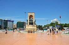
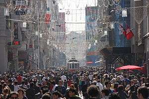
The Fatih district, which was named after Sultan Mehmed the Conqueror (Turkish: Fatih Sultan Mehmed), corresponds to what was, until the Ottoman conquest in 1453, the whole of the city of Constantinople (today is the capital district and called the historic peninsula of Istanbul) on the southern shore of the Golden Horn, across the medieval Genoese citadel of Galata on the northern shore. The Genoese fortifications in Galata were largely demolished in the 19th century, leaving only the Galata Tower, to make way for the northward expansion of the city.[132] Galata (Karaköy) is today a quarter within the Beyoğlu (Pera) district, which forms Istanbul's commercial and entertainment center and includes İstiklal Avenue and Taksim Square.[133]
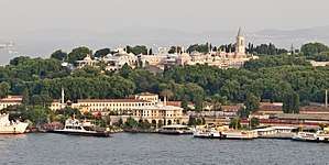
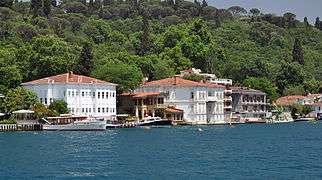
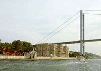
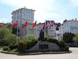
Dolmabahçe Palace, the seat of government during the late Ottoman period, is located in the Beşiktaş district on the European shore of the Bosphorus strait, to the north of Beyoğlu. The Sublime Porte (Bâb-ı Âli), which became a metonym for the Ottoman government, was originally used to describe the Imperial Gate (Bâb-ı Hümâyûn) at the outermost courtyard of the Topkapı Palace; but after the 18th century, the Sublime Porte (or simply Porte) began to refer to the gate of the Sadrazamlık (Prime Ministry) compound in the Cağaloğlu quarter near Topkapı Palace, where the offices of the Sadrazam (Grand Vizier) and other Viziers were located, and where foreign diplomats were received. The former village of Ortaköy is situated within Beşiktaş and gives its name to the Ortaköy Mosque on the Bosphorus, near the Bosphorus Bridge. Lining both the European and Asian shores of the Bosphorus are the historic yalıs, luxurious chalet mansions built by Ottoman aristocrats and elites as summer homes.[134] Farther inland, outside the city's inner ring road, are Levent and Maslak, Istanbul's main business districts.[135]
During the Ottoman period, Üsküdar and Kadıköy were outside the scope of urban Istanbul, serving as tranquil outposts with seaside yalıs and gardens. But in the second half of the 20th century, the Asian side experienced major urban growth; the late development of this part of the city led to better infrastructure and tidier urban planning when compared with most other residential areas in the city.[9] Much of the Asian side of the Bosphorus functions as a suburb of the economic and commercial centers in European Istanbul, accounting for a third of the city's population but only a quarter of its employment.[9] As a result of Istanbul's exponential growth in the 20th century, a significant portion of the city is composed of gecekondus (literally "built overnight"), referring to illegally constructed squatter buildings.[136] At present, some gecekondu areas are being gradually demolished and replaced by modern mass-housing compounds.[137] Moreover, large scale gentrification and urban renewal projects have been taking place,[138] such as the one in Tarlabaşı;[139] some of these projects, like the one in Sulukule, have faced criticism.[140] The Turkish government also has ambitious plans for an expansion of the city west and northwards on the European side in conjunction with plans for a third airport; the new parts of the city will include four different settlements with specified urban functions, housing 1.5 million people.[141]
Istanbul does not have a primary urban park, but it has several green areas. Gülhane Park and Yıldız Park were originally included within the grounds of two of Istanbul's palaces—Topkapı Palace and Yıldız Palace—but they were repurposed as public parks in the early decades of the Turkish Republic.[142] Another park, Fethi Paşa Korusu, is situated on a hillside adjacent to the Bosphorus Bridge in Anatolia, opposite Yıldız Palace in Europe. Along the European side, and close to the Fatih Sultan Mehmet Bridge, is Emirgan Park, which was known as the Kyparades (Cypress Forest) during the Byzantine period. In the Ottoman period, it was first granted to Nişancı Feridun Ahmed Pasha in the 16th century, before being granted by Sultan Murad IV to the Safavid Emir Gûne Han in the 17th century, hence the name Emirgan. The 47-hectare (120-acre) park was later owned by Khedive Ismail Pasha of Ottoman Egypt and Sudan in the 19th century. Emirgan Park is known for its diversity of plants and an annual tulip festival is held there since 2005.[143] The AKP government's decision to replace Taksim Gezi Park with a replica of the Ottoman era Taksim Military Barracks (which was transformed into the Taksim Stadium in 1921, before being demolished in 1940 for building Gezi Park) sparked a series of nationwide protests in 2013 covering a wide range of issues. Popular during the summer among Istanbulites is Belgrad Forest, spreading across 5,500 hectares (14,000 acres) at the northern edge of the city. The forest originally supplied water to the city and remnants of reservoirs used during Byzantine and Ottoman times survive.[144][145]
Architecture
.jpg)
.JPG)

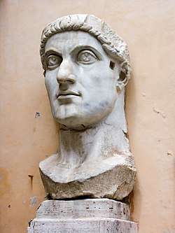
Istanbul is primarily known for its Byzantine and Ottoman architecture, but its buildings reflect the various peoples and empires that have previously ruled the city. Examples of Genoese and Roman architecture remain visible in Istanbul alongside their Ottoman counterparts. Nothing of the architecture of the classical Greek period has survived, but Roman architecture has proved to be more durable. The obelisk erected by Theodosius in the Hippodrome of Constantinople is still visible in Sultanahmet Square, and a section of the Valens Aqueduct, constructed in the late 4th century, stands relatively intact at the western edge of the Fatih district.[147] The Column of Constantine, erected in 330 CE to mark the new Roman capital, stands not far from the Hippodrome.[147]

Early Byzantine architecture followed the classical Roman model of domes and arches, but improved upon these elements, as in the Church of the Saints Sergius and Bacchus. The oldest surviving Byzantine church in Istanbul—albeit in ruins—is the Monastery of Stoudios (later converted into the Imrahor Mosque), which was built in 454.[149] After the recapture of Constantinople in 1261, the Byzantines enlarged two of the most important churches extant, Chora Church and Pammakaristos Church. The pinnacle of Byzantine architecture, and one of Istanbul's most iconic structures, is the Hagia Sophia. Topped by a dome 31 meters (102 ft) in diameter,[150] the Hagia Sophia stood as the world's largest cathedral for centuries, and was later converted into a mosque and, as it stands now, a museum.[58]
Among the oldest surviving examples of Ottoman architecture in Istanbul are the Anadoluhisarı and Rumelihisarı fortresses, which assisted the Ottomans during their siege of the city.[151] Over the next four centuries, the Ottomans made an indelible impression on the skyline of Istanbul, building towering mosques and ornate palaces. The largest palace, Topkapı, includes a diverse array of architectural styles, from Baroque inside the Harem, to its Neoclassical style Enderûn Library.[152] The imperial mosques include Fatih Mosque, Bayezid Mosque, Yavuz Selim Mosque, Süleymaniye Mosque, Sultan Ahmed Mosque (the Blue Mosque), and Yeni Mosque, all of which were built at the peak of the Ottoman Empire, in the 16th and 17th centuries. In the following centuries, and especially after the Tanzimat reforms, Ottoman architecture was supplanted by European styles.[153] An example of which is the imperial Nuruosmaniye Mosque. Areas around İstiklal Avenue were filled with grand European embassies and rows of buildings in Neoclassical, Renaissance Revival and Art Nouveau styles, which went on to influence the architecture of a variety of structures in Beyoğlu—including churches, stores, and theaters—and official buildings such as Dolmabahçe Palace.[154]
Administration
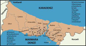
Since 2004, the municipal boundaries of Istanbul have been coincident with the boundaries of its province.[155] The city, considered capital of Istanbul Province, is administered by the Istanbul Metropolitan Municipality (MMI), which oversees the 39 districts of the city-province.[lower-alpha 2]
The current city structure can be traced back to the Tanzimat period of reform in the 19th century, before which Islamic judges and imams led the city under the auspices of the Grand Vizier. Following the model of French cities, this religious system was replaced by a mayor and a citywide council composed of representatives of the confessional groups (millet) across Istanbul. Beyoğlu was the first area of the city to have its own director and council, with members instead being longtime residents of the neighborhood.[156] Laws enacted after the Ottoman constitution of 1876 aimed to expand this structure across the city, imitating the twenty arrondissements of Paris, but they were not fully implemented until 1908, when Istanbul was declared a province with nine constituent districts.[157][158] This system continued beyond the founding of the Turkish Republic, with the province renamed a belediye (municipality), but the municipality was disbanded in 1957.[94][159]
Small settlements adjacent to major population centers in Turkey, including Istanbul, were merged into their respective primary cities during the early 1980s, resulting in metropolitan municipalities.[160][161] The main decision-making body of the Istanbul Metropolitan Municipality is the Municipal Council, with members drawn from district councils.
The Municipal Council is responsible for citywide issues, including managing the budget, maintaining civic infrastructure, and overseeing museums and major cultural centers.[162] Since the government operates under a "powerful mayor, weak council" approach, the council's leader—the metropolitan mayor—has the authority to make swift decisions, often at the expense of transparency.[163] The Municipal Council is advised by the Metropolitan Executive Committee, although the Committee also has limited power to make decisions of its own.[164] All representatives on the Committee are appointed by the metropolitan mayor and the Council, with the mayor—or someone of his or her choosing—serving as head.[164][165]
District councils are chiefly responsible for waste management and construction projects within their respective districts. They each maintain their own budgets, although the metropolitan mayor reserves the right to review district decisions. One-fifth of all district council members, including the district mayors, also represent their districts in the Municipal Council.[162] All members of the district councils and the Municipal Council, including the metropolitan mayor, are elected to five-year terms.[166] Representing the Justice and Development Party, Mevlüt Uysal has been the Mayor of Istanbul since September 28, 2017.[167]
With the Istanbul Metropolitan Municipality and Istanbul Province having equivalent jurisdictions, few responsibilities remain for the provincial government. Similar to the MMI, the Istanbul Special Provincial Administration has a governor, a democratically elected decision-making body—the Provincial Parliament—and an appointed Executive Committee. Mirroring the executive committee at the municipal level, the Provincial Executive Committee includes a secretary-general and leaders of departments that advise the Provincial Parliament.[165][168] The Provincial Administration's duties are largely limited to the building and maintenance of schools, residences, government buildings, and roads, and the promotion of arts, culture, and nature conservation.[169] Vasip Şahin has been the Governor of Istanbul Province since September 25, 2014.[170]
Demographics
|
| ||||||||||||||||||||||||||||||||||||||||||||||||||||||||||||||||||||||||||||||||||||||||||||||||||||||
| Sources: Jan Lahmeyer 2004,Chandler 1987, Morris 2010,Turan 2010 Pre-Republic figures estimated[lower-alpha 4] | |||||||||||||||||||||||||||||||||||||||||||||||||||||||||||||||||||||||||||||||||||||||||||||||||||||||
Throughout most of its history, Istanbul has ranked among the largest cities in the world. By 500 CE, Constantinople had somewhere between 400,000 and 500,000 people, edging out its predecessor, Rome, for world's largest city.[172] Constantinople jostled with other major historical cities, such as Baghdad, Chang'an, Kaifeng and Merv for the position of world's most populous city until the 12th century. It never returned to being the world's largest, but remained Europe's largest city from 1500 to 1750, when it was surpassed by London.[173]
The Turkish Statistical Institute estimates that the population of Istanbul Metropolitan Municipality was 14,377,019 at the end of 2014, hosting 19 percent of the country's population.[3] Then about 97–98% of the inhabitants of the metropolitan municipality were within city limits, up from 89% in 2007[174] and 61% in 1980.[175] 64.9% of the residents live on the European side and 35.1% on the Asian side.[176] While the city ranks as the world's 5th-largest city proper, it drops to the 24th place as an urban area and to the 18th place as a metro area because the city limits are roughly equivalent to the agglomeration. Today, it forms one of the largest urban agglomerations in Europe, alongside Moscow.[lower-alpha 5] The city's annual population growth of 3.45 percent ranks as the highest among the seventy-eight largest metropolises in the Organisation for Economic Co-operation and Development. The high population growth mirrors an urbanization trend across the country, as the second and third fastest-growing OECD metropolises are the Turkish cities of İzmir and Ankara.[18]
Istanbul experienced especially rapid growth during the second half of the 20th century, with its population increasing tenfold between 1950 and 2000.[13] This growth in population comes, in part, from an expansion of city limits—particularly between 1980 and 1985, when the number of Istanbulites nearly doubled.[94] The remarkable growth was, and still is, largely fueled by migrants from eastern Turkey seeking employment and improved living conditions. The number of residents of Istanbul originating from seven northern and eastern provinces is greater than the populations of their entire respective provinces; Sivas and Kastamonu each account for more than half a million residents of Istanbul.[14] Istanbul's foreign population, by comparison, is very small, 42,228 residents in 2007.[179] Only 28 percent of the city's residents are originally from Istanbul.[180] The most densely populated areas tend to lie to the northwest, west, and southwest of the city center, on the European side; the most densely populated district on the Asian side is Üsküdar.[14]
Religious and ethnic groups

Istanbul has been a cosmopolitan city throughout much of its history, but it has become more homogenized since the end of the Ottoman Empire. The vast majority of people across Turkey, and in Istanbul, are Muslim, and more specifically members of the Sunni branch of Islam. Most Sunnis follow the Hanafi school of Islamic thought, although approximately 10 percent of Sunnis follow the Shafi'i school. The largest non-Sunni Muslim sect, accounting for 4.5 million Turks, is the Alevis; a third of all Alevis in the country live in Istanbul.[180] Mystic movements, like Sufism, were officially banned after the establishment of the Turkish Republic, but they still boast numerous followers.[181]
The Patriarch of Constantinople has been designated Ecumenical Patriarch since the sixth century, and has subsequently come to be widely regarded as the leader of the world's 300 million Orthodox Christians.[182] Since 1601, the Patriarchate has been based in Istanbul's Church of St. George.[183] Into the 19th century, the Christians of Istanbul tended to be either Greek Orthodox or members of the Armenian Apostolic Church.[184] The headquarters of the Turkish Orthodox Church are located in the city. Because of events during the 20th century—including the 1923 population exchange between Greece and Turkey, a 1942 wealth tax, and the 1955 Istanbul riots—the Greek population, originally centered in Fener and Samatya, has decreased substantially. At the start of the 21st century, Istanbul's Greek population numbered 3,000 (down from 130,000 in 1923 and 260,000 according to the Ottoman Census of 1910 of 850,000 total).[185][186] There are today between 50,000 and 90,000 Armenians in Istanbul, down from about 164,000 in 1913 (partly due to the Armenian Genocide) according to the Ottoman Census.[187]

The largest ethnic minority in Istanbul is the Kurdish community, originating from eastern and southeastern Turkey. Although the Kurdish presence in the city dates back to the early Ottoman period,[188] the influx of Kurds into the city has accelerated since the beginning of the Kurdish–Turkish conflict with the PKK (i.e. since the late 1970s).[189] About two to three million residents of Istanbul are Kurdish, meaning there are more Kurds in Istanbul than in any other city in the world.[190][191][192][193][194] There are other significant ethnic minorities as well, the Bosniaks are the main people of an entire district – Bayrampaşa.[195] The neighborhood of Balat used to be home to a sizable Sephardi Jewish community, first formed after their expulsion from Spain in 1492.[196] Romaniotes and Ashkenazi Jews resided in Istanbul even before the Sephardim, but their proportion has since dwindled; today, 1 percent of Istanbul's Jews are Ashkenazi.[197][198] In large part due to emigration to Israel, the Jewish population nationwide dropped from 100,000 in 1950 to 18,000 in 2005, with the majority of them living in either Istanbul or İzmir.[199] Levantines, Latin Christians who settled in Galata during the Ottoman period, played a seminal role in shaping the culture and architecture of Istanbul during the 19th and early 20th centuries; their population has dwindled, but they remain in the city in small numbers.[200] From the increase in mutual cooperation between Turkey and several African States like Somalia and Djibouti, several young students and workers have been migrating to Istanbul in search of better education and employment opportunities. There is also a small Nigerian, Congolese and Cameroonian and North African community present.[201]
Politics
İstanbul district Municipalities Turkish local elections, 2014 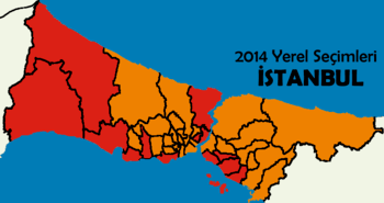 | |
|---|---|
| AK Party |
25 / 39
|
| CHP |
14 / 39
|
Members of Parliament for İstanbul Turkish general election, November 2015 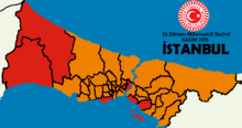 | |
|---|---|
| AK Party |
46 / 88
|
| CHP |
28 / 88
|
| HDP |
7 / 88
|
| MHP |
7 / 88
|
Istanbul has voted for the winning party in general elections since 1995. Since 2002, the right-wing Justice and Development Party (AKP) has won pluralities in every general and local election. The city's electorate has also voted for the AKP government's constitutional reforms proposed during the 2007 and 2010 constitutional referenda. Turkish President and former AKP Prime Minister Recep Tayyip Erdoğan was elected Mayor of İstanbul in the 1994 local elections as the Islamist Welfare Party candidate with 25.1% of the vote, winning due to a vote split between the mainstream centrist parties. Conservative parties traditionally find support in older districts with high population densities such as Bağcılar, Fatih, Sultanbeyli and Esenler. The opposition Kemalist center-left Republican People's Party (CHP), currently the second major political force in both İstanbul and the country, gets most of its support from more rural districts such as Silivri, Çatalca and Sarıyer. Urban districts such as Beşiktaş, Bakırköy, Şişli and Kadıköy have returned strong support for the CHP in past elections. The CHP are generally strongest in the west, where newer residential developments are taking place. İstanbul has 39 districts, more than any other province in Turkey. Since İstanbul is Turkey's largest city and has usually voted in the same way as the country as a whole, it is largely perceived in Turkish politics that the winning party of an election is essentially decided by İstanbul's electorate. Political parties thus allocate substantial amounts of electoral campaign funds and to winning control of the İstanbul Metropolitan Municipality. Due to its electoral importance, İstanbul has reported the largest and most serious cases of electoral fraud in recent elections, including the 2014 local elections.[202][203][204][205][206][207][208]
The incumbent mayor of the city is Mevlüt Uysal of the AKP, who was elected after the resignation of the previous mayor, Kadir Topbaş. The leader of the CHP and parliamentary opposition, Kemal Kılıçdaroğlu, ran against Topbaş in the 2009 local elections. He is currently a Member of Parliament for İstanbul. Between 2007 and 2014, Prime Minister Recep Tayyip Erdoğan was also an MP for İstanbul. For general elections, the city is divided into 3 electoral districts and returns 85 MPs to the Turkish parliament. In the 2014 presidential election, 49.83% of the city's electorate voted for AKP candidate Recep Tayyip Erdoğan. Although Erdoğan won the most votes in İstanbul, his failure to win above 50% was seen as significant. Opposition candidate Ekmeleddin İhsanoğlu came second with 41.08% and the HDP pro-Kurdish and left-wing candidate Selahattin Demirtaş won a substantial 9.09%.[209] In 2013 and 2014, large-scale anti-AKP government protests began in İstanbul and spread throughout the nation.
Economy
With a PPP-adjusted gross domestic product of US$301.1 billion, Istanbul ranked 29th among the world's urban areas in 2011.[210] Since the mid-1990s, Istanbul's economy has been one of the fastest-growing among OECD metro-regions.[18] Istanbul is responsible for 27 percent of Turkey's GDP, with 20 percent of the country's industrial labor force residing in the city.[18][211] Its GDP per capita and productivity are greater than their national averages by 70 percent and 50 percent, respectively, owing in part to the focus on high-value-added activities. With its high population and significant contribution to the Turkish economy, Istanbul is responsible for two-fifths of the nation's tax revenue.[18] That includes the taxes of 37 US-dollar billionaires based in Istanbul, the fifth-highest number among cities around the world.[212]
As expected for a city of its size, Istanbul has a diverse industrial economy, producing commodities as varied as olive oil, tobacco, vehicles, and electronics.[211] Despite having a focus on high-value-added work, its low-value-added manufacturing sector is substantial, representing just 26 percent of Istanbul's GDP, but four-fifths of the city's total exports.[18] In 2005, companies based in Istanbul produced exports worth $41.4 billion and received imports totaling $69.9 billion; these figures were equivalent to 57 percent and 60 percent, respectively, of the national totals.[213]
Istanbul is home to Borsa Istanbul, the sole exchange entity of Turkey, which combined the former Istanbul Stock Exchange, the Istanbul Gold Exchange, and the Derivatives Exchange of Turkey.[214] The former Istanbul Stock Exchange was originally established as the Ottoman Stock Exchange in 1866.[215] During the 19th and early 20th centuries, Bankalar Caddesi (Banks Street) in Galata was the financial center of the Ottoman Empire, where the Ottoman Stock Exchange was located.[216] Bankalar Caddesi continued to be Istanbul's main financial district until the 1990s, when most Turkish banks began moving their headquarters to the modern central business districts of Levent and Maslak. In 1995, the Istanbul Stock Exchange (now Borsa Istanbul) moved to its current building in the İstinye quarter of the Sarıyer district.[217] A new central business district is also under construction in Ataşehir and will host the headquarters of various Turkish banks and financial institutions upon completion.[218]
.jpg)
As the only sea route between the oil-rich Black Sea and the Mediterranean, the Bosphorus is one of the busiest waterways in the world; more than 200 million tonnes of oil pass through the strait each year, and the traffic on the Bosphorus is three times that on the Suez Canal.[219] As a result, there have been proposals to build a canal, known as Canal Istanbul, parallel to the strait, on the European side of the city.[220] Istanbul has three major shipping ports—the Port of Haydarpaşa, the Port of Ambarlı, and the Port of Zeytinburnu—as well as several smaller ports and oil terminals along the Bosphorus and the Sea of Marmara.[221][222] Haydarpaşa, situated at the southeastern end of the Bosphorus, was Istanbul's largest port until the early 2000s. Shifts in operations to Ambarlı since then have left Haydarpaşa running under capacity and with plans to decommission the port.[223] In 2007, Ambarlı, on the western edge of the urban center, had an annual capacity of 1.5 million TEUs (compared to 354,000 TEUs at Haydarpaşa), making it the fourth-largest cargo terminal in the Mediterranean basin.[224][225] The Port of Zeytinburnu is advantaged by its proximity to motorways and Atatürk International Airport,[226] and long-term plans for the city call for greater connectivity between all terminals and the road and rail networks.[227]
Istanbul is an increasingly popular tourist destination; whereas just 2.4 million foreigners visited the city in 2000, it welcomed 12.56 million foreign tourists in 2015, making it the world's fifth most-visited city.[15][228] Istanbul is Turkey's second-largest international gateway, after Antalya, receiving a quarter of the nation's foreign tourists. Istanbul's tourist industry is concentrated in the European side, with 90 percent of the city's hotels located there. Low- and mid-range hotels tend to be located on the Sarayburnu; higher-end hotels are primarily located in the entertainment and financial centers north of the Golden Horn. Istanbul's seventy museums, the most visited of which are the Topkapı Palace Museum and the Hagia Sophia, bring in $30 million in revenue each year. The city's environmental master plan also notes that there are 17 palaces, 64 mosques, and 49 churches of historical significance in Istanbul.[229]
Culture
_-_Mart_2013.JPG)
Istanbul was historically known as a cultural hub, but its cultural scene stagnated after the Turkish Republic shifted its focus toward Ankara.[231] The new national government established programs that served to orient Turks toward musical traditions, especially those originating in Europe, but musical institutions and visits by foreign classical artists were primarily centered in the new capital.[232] Much of Turkey's cultural scene had its roots in Istanbul, and by the 1980s and 1990s Istanbul reemerged globally as a city whose cultural significance is not solely based on its past glory.[233]
By the end of the 19th century, Istanbul had established itself as a regional artistic center, with Turkish, European, and Middle Eastern artists flocking to the city. Despite efforts to make Ankara Turkey's cultural heart, Istanbul had the country's primary institution of art until the 1970s.[234] When additional universities and art journals were founded in Istanbul during the 1980s, artists formerly based in Ankara moved in.[235] Beyoğlu has been transformed into the artistic center of the city, with young artists and older Turkish artists formerly residing abroad finding footing there. Modern art museums, including İstanbul Modern, the Pera Museum, Sakıp Sabancı Museum and SantralIstanbul, opened in the 2000s to complement the exhibition spaces and auction houses that have already contributed to the cosmopolitan nature of the city.[236] These museums have yet to attain the popularity of older museums on the historic peninsula, including the Istanbul Archaeology Museums, which ushered in the era of modern museums in Turkey, and the Turkish and Islamic Arts Museum.[229][230]
The first film screening in Turkey was at Yıldız Palace in 1896, a year after the technology publicly debuted in Paris.[241] Movie theaters rapidly cropped up in Beyoğlu, with the greatest concentration of theaters being along the street now known as İstiklal Avenue.[242] Istanbul also became the heart of Turkey's nascent film industry, although Turkish films were not consistently developed until the 1950s.[243] Since then, Istanbul has been the most popular location to film Turkish dramas and comedies.[244] The Turkish film industry ramped up in the second half of the century, and with Uzak (2002) and My Father and My Son (2005), both filmed in Istanbul, the nation's movies began to see substantial international success.[245] Istanbul and its picturesque skyline have also served as a backdrop for several foreign films, including From Russia with Love (1963), Topkapi (1964), The World Is Not Enough (1999), and Mission Istaanbul (2008).[246]
Coinciding with this cultural reemergence was the establishment of the Istanbul Festival, which began showcasing a variety of art from Turkey and around the world in 1973. From this flagship festival came the International Istanbul Film Festival and the Istanbul International Jazz Festival in the early 1980s. With its focus now solely on music and dance, the Istanbul Festival has been known as the Istanbul International Music Festival since 1994.[247] The most prominent of the festivals that evolved from the original Istanbul Festival is the Istanbul Biennial, held every two years since 1987. Its early incarnations were aimed at showcasing Turkish visual art, and it has since opened to international artists and risen in prestige to join the elite biennales, alongside the Venice Biennale and the São Paulo Art Biennial.[248]
Leisure and entertainment
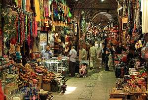
Istanbul has numerous shopping centers, from the historic to the modern. The Grand Bazaar, in operation since 1461, is among the world's oldest and largest covered markets.[249][250] Mahmutpasha Bazaar is an open-air market extending between the Grand Bazaar and the Egyptian Bazaar, which has been Istanbul's major spice market since 1660. Galleria Ataköy ushered in the age of modern shopping malls in Turkey when it opened in 1987.[251] Since then, malls have become major shopping centers outside the historic peninsula. Akmerkez was awarded the titles of "Europe's best" and "World's best" shopping mall by the International Council of Shopping Centers in 1995 and 1996; Istanbul Cevahir has been one of the continent's largest since opening in 2005; Kanyon won the Cityscape Architectural Review Award in the Commercial Built category in 2006.[250] İstinye Park in İstinye and Zorlu Center near Levent are among the newest malls which include the stores of the world's top fashion brands. Abdi İpekçi Street in Nişantaşı and Bağdat Avenue on the Anatolian side of the city have evolved into high-end shopping districts.[252][253]
Istanbul is famous for its historic seafood restaurants. Many of the city's most popular and upscale seafood restaurants line the shores of the Bosphorus (particularly in neighborhoods like Ortaköy, Bebek, Arnavutköy, Yeniköy, Beylerbeyi and Çengelköy). Kumkapı along the Sea of Marmara has a pedestrian zone that hosts around fifty fish restaurants.[254] The Prince Islands, 15 kilometers (9 mi) from the city center, are also popular for their seafood restaurants. Because of their restaurants, historic summer mansions, and tranquil, car-free streets, the Prince Islands are a popular vacation destination among Istanbulites and foreign tourists.[255] Istanbul is also famous for its sophisticated and elaborately-cooked dishes of the Ottoman cuisine. However, following the influx of immigrants from southeastern and eastern Turkey, which began in the 1960s, the foodscape of the city has drastically changed by the end of the century; with influences of Middle Eastern cuisine such as kebab taking an important place in the food scene. Restaurants featuring foreign cuisines are mainly concentrated in the Beyoğlu, Beşiktaş, Şişli, and Kadıköy districts.
Istanbul is famous for its nightlife, as well as its historic taverns, a signature characteristic of the city for centuries if not millennia. Along İstiklal Avenue is the Çiçek Pasajı, now home to winehouses (known as meyhanes), pubs, and restaurants.[256] İstiklal Avenue, originally famous for its taverns, has shifted toward shopping, but the nearby Nevizade Street is still lined with winehouses and pubs.[257][258] Some other neighborhoods around İstiklal Avenue have recently been revamped to cater to Beyoğlu's nightlife, with formerly commercial streets now lined with pubs, cafes, and restaurants playing live music.[259] Other focal points for Istanbul's nightlife include Nişantaşı, Ortaköy, Bebek, and Kadıköy.[260]
Sports

Istanbul is home to some of Turkey's oldest sports clubs. Beşiktaş JK, established in 1903, is considered the oldest of these sports clubs. Due to its initial status as Turkey's only club, Beşiktaş occasionally represented the Ottoman Empire and Turkish Republic in international sports competitions, earning the right to place the Turkish flag inside its team logo.[261] Galatasaray SK and Fenerbahçe SK have fared better in international competitions and have won more Süper Lig titles, at 21 and 19 times, respectively.[262][263][264] Galatasaray and Fenerbahçe have a long-standing rivalry, with Galatasaray based in the European part and Fenerbahçe based in the Anatolian part of the city.[263] Istanbul has seven basketball teams—Anadolu Efes, Beşiktaş, Darüşşafaka, Fenerbahçe, Galatasaray, İstanbul Büyükşehir Belediyespor and Büyükçekmece—that play in the premier-level Turkish Basketball Super League.[265]
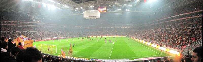
Many of Istanbul's sports facilities have been built or upgraded since 2000 to bolster the city's bids for the Summer Olympic Games. Atatürk Olympic Stadium, the largest multi-purpose stadium in Turkey, was completed in 2002 as an IAAF first-class venue for track and field.[266] The stadium hosted the 2005 UEFA Champions League Final and will host the 2020 UEFA Champions League Final.[267] Şükrü Saracoğlu Stadium, Fenerbahçe's home field, hosted the 2009 UEFA Cup Final three years after its completion. Türk Telekom Arena opened in 2011 to replace Ali Sami Yen Stadium as Galatasaray's home turf,[268][269] while Vodafone Arena opened in 2016 to replace BJK İnönü Stadium as the home turf of Beşiktaş, which won the Süper Lig in the same season. All four stadiums are elite Category 4 (formerly five-star) UEFA stadiums.[lower-alpha 6]

The Sinan Erdem Dome, among the largest indoor arenas in Europe, hosted the final of the 2010 FIBA World Championship, the 2012 IAAF World Indoor Championships, as well as the 2011–12 Euroleague and 2016-17 EuroLeague Final Fours.[273] Prior to the completion of the Sinan Erdem Dome in 2010, Abdi İpekçi Arena was Istanbul's primary indoor arena, having hosted the finals of EuroBasket 2001.[274] Several other indoor arenas, including the Beşiktaş Akatlar Arena, have also been inaugurated since 2000, serving as the home courts of Istanbul's sports clubs. The most recent of these is the 13,800-seat Ülker Sports Arena, which opened in 2012 as the home court of Fenerbahçe's basketball teams.[275] Despite the construction boom, five bids for the Summer Olympics—in 2000, 2004, 2008, 2012, and 2020—and national bids for UEFA Euro 2012 and UEFA Euro 2016 have ended unsuccessfully.[276]
The TVF Burhan Felek Sport Hall is one of the major volleyball arenas in the city and hosts clubs such as Eczacıbaşı VitrA, Vakıfbank SK, and Fenerbahçe who have won numerous European and World Championship titles.
Between 2005 and 2011, Istanbul Park racing circuit hosted the annual Formula One Turkish Grand Prix.[277] Istanbul Park was also a venue of the World Touring Car Championship and the European Le Mans Series in 2005 and 2006, but the track has not seen either of these competitions since then.[278][279] It also hosted the Turkish Motorcycle Grand Prix between 2005 and 2007. Istanbul was occasionally a venue of the F1 Powerboat World Championship, with the last race on the Bosphorus strait on 12–13 August 2000.[280] The last race of the Powerboat P1 World Championship on the Bosphorus took place on 19–21 June 2009.[281] Istanbul Sailing Club, established in 1952, hosts races and other sailing events on the waterways in and around Istanbul each year.[282][283] Turkish Offshore Racing Club also hosts major yacht races, such as the annual Naval Forces Trophy.[284]
Media

Most state-run radio and television stations are based in Ankara, but Istanbul is the primary hub of Turkish media. The industry has its roots in the former Ottoman capital, where the first Turkish newspaper, Takvim-i Vekayi (Calendar of Affairs), was published in 1831. The Cağaloğlu street on which the newspaper was printed, Bâb-ı Âli Street, rapidly became the center of Turkish print media, alongside Beyoğlu across the Golden Horn.[285]
Today, Istanbul hosts a wide variety of periodicals. Most nationwide newspapers are based in Istanbul, with simultaneous Ankara and İzmir editions.[286] Hürriyet, Sabah, Posta and Sözcü, the country's top four papers, are all headquartered in Istanbul, boasting more than 275,000 weekly sales each.[287] Hürriyet's English-language edition, Hürriyet Daily News, has been printed since 1961, but the English-language Daily Sabah, first published by Sabah in 2014, has overtaken it in circulation. Several smaller newspapers, including popular publications like Cumhuriyet, Milliyet and Habertürk are also based in Istanbul.[286] Istanbul also has long-running Armenian language newspapers, notably the dailies Marmara and Jamanak and the bilingual weekly Agos in Armenian and Turkish.
Radio broadcasts in Istanbul date back to 1927, when Turkey's first radio transmission came from atop the Central Post Office in Eminönü. Control of this transmission, and other radio stations established in the following decades, ultimately came under the state-run Turkish Radio and Television Corporation (TRT), which held a monopoly on radio and television broadcasts between its founding in 1964 and 1990.[288] Today, TRT runs four national radio stations; these stations have transmitters across the country so each can reach over 90 percent of the country's population, but only Radio 2 is based in Istanbul. Offering a range of content from educational programming to coverage of sporting events, Radio 2 is the most popular radio station in Turkey.[288] Istanbul's airwaves are the busiest in Turkey, primarily featuring either Turkish-language or English-language content. One of the exceptions, offering both, is Açık Radyo (94.9 FM). Among Turkey's first private stations, and the first featuring foreign popular music, was Istanbul's Metro FM (97.2 FM). The state-run Radio 3, although based in Ankara, also features English-language popular music, and English-language news programming is provided on NTV Radyo (102.8 FM).[289]
TRT-Children is the only TRT television station based in Istanbul.[290] Istanbul is home to the headquarters of several Turkish stations and regional headquarters of international media outlets. Istanbul-based Star TV was the first private television network to be established following the end of the TRT monopoly; Star TV and Show TV (also based in Istanbul) remain highly popular throughout the country, airing Turkish and American series.[291] Kanal D and ATV are other stations in Istanbul that offer a mix of news and series; NTV (partnered with U.S. media outlet MSNBC) and Sky Turk—both based in the city—are mainly just known for their news coverage in Turkish. The BBC has a regional office in Istanbul, assisting its Turkish-language news operations, and the American news channel CNN established the Turkish-language CNN Türk there in 1999.[292] The Istanbul-based business and entertainment channel CNBC-e began broadcasting in 2000.
Education
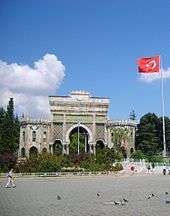
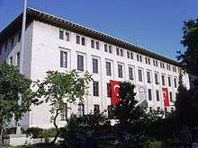
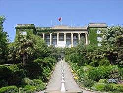
Istanbul University, founded in 1453, is the oldest Turkish educational institution in the city. Although originally an Islamic school, the university established law, medicine, and science departments in the 19th century and was secularized after the founding of the Turkish Republic.[293] Istanbul Technical University, founded in 1773, is the world's third-oldest university dedicated entirely to engineering sciences.[294][295] These public universities are two of just eight across the city;[296] other prominent state universities in Istanbul include the Mimar Sinan Fine Arts University, which served as Turkey's primary institution of art until the 1970s,[234] and Marmara University, the country's third-largest institution of higher learning.[297]
Most established universities in Istanbul are backed by the government; the city also has several prominent private institutions. The first modern private university in Istanbul, also the oldest American school in existence in its original location outside the United States, was Robert College, founded by Christopher Robert, an American philanthropist, and Cyrus Hamlin, a missionary devoted to education, in 1863. The tertiary element of its education program became the public Boğaziçi University in 1971; the remaining portion in Arnavutköy continues as a boarding high-school under the name Robert College.[298][299] Private universities were officially outlawed in Turkey before the Constitution of 1982, but there were already fifteen private "higher schools", which were effectively universities, in Istanbul by 1970. The first private university established in Istanbul since 1982 was Koç University (founded in 1992), and another dozen had opened within the following decade.[298] Today, there are at least 30 private universities in the city, including Istanbul Commerce University and Kadir Has University.[300] A new biomedical research and development hub, called Bio Istanbul, is under construction in Başakşehir, and will host 15,000 residents, 20,000 working commuters, and a university upon completion.[301][302]
In 2007, there were about 4,350 schools, about half of which were primary schools; on average, each school had 688 students. In recent years, Istanbul's educational system has expanded substantially; from 2000 to 2007, the number of classrooms and teachers nearly doubled and the number of students increased by more than 60 percent.[303] Galatasaray High School, established in 1481 as the Galata Palace Imperial School, is the oldest high school in Istanbul and the second-oldest educational institution in the city. It was built at the behest of Sultan Bayezid II, who sought to bring students with diverse backgrounds together as a means of strengthening his growing empire.[304] It is one of Turkey's Anatolian High Schools, elite public high schools that place a stronger emphasis on instruction in foreign languages. Galatasaray, for example, offers instruction in French; other Anatolian High Schools primarily teach in English or German alongside Turkish.[305][306] The city also has foreign high schools, such as Liceo Italiano, that were established in the 19th century to educate foreigners.[307]
Kuleli Military High School, along the shores of the Bosphorus in Çengelköy, and Turkish Naval High School, located on one of the Princes' Islands, were military high schools, complemented by three military academies—the Turkish Air Force, Turkish Military, and Turkish Naval Academies. Both schools were shut Darüşşafaka High School provides free education to children across the country missing at least one parent. Darüşşafaka begins instruction with the fourth grade, providing instruction in English and, starting in sixth grade, a second foreign language—German or French.[308] Other prominent high schools in the city include Istanbul Lisesi (founded in 1884), Kabataş Erkek Lisesi (founded in 1908)[309] and Kadıköy Anadolu Lisesi (founded in 1955).[310]
Public services
Istanbul's first water supply systems date back to the city's early history, when aqueducts (such as the Valens Aqueduct) deposited the water in the city's numerous cisterns.[311] At the behest of Suleiman the Magnificent, the Kırkçeşme water supply network was constructed; by 1563, the network provided 4,200 cubic meters (150,000 cu ft) of water to 158 sites each day.[311] In later years, in response to increasing public demand, water from various springs was channeled to public fountains, like the Fountain of Ahmed III, by means of supply lines.[312] Today, Istanbul has a chlorinated and filtered water supply and a sewage treatment system managed by the Istanbul Water and Sewerage Administration (İstanbul Su ve Kanalizasyon İdaresi, İSKİ).[313]
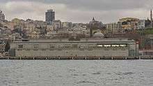
The Silahtarağa Power Station, a coal-fired power plant along the Golden Horn, was the sole source of Istanbul's electricity between 1914, when its first engine room was completed, and 1952.[314] Following the founding of the Turkish Republic, the plant underwent renovations to accommodate the city's increasing demand; its capacity grew from 23 megawatts in 1923 to a peak of 120 megawatts in 1956.[314][315] Capacity declined until the power station reached the end of its economic life and shut down in 1983.[314] The state-run Turkish Electrical Authority (TEK) briefly—between its founding in 1970 and 1984—held a monopoly on the generation and distribution of electricity, but now the authority—since split between the Turkish Electricity Generation Transmission Company (TEAŞ) and the Turkish Electricity Distribution Company (TEDAŞ)—competes with private electric utilities.[315]
The Ottoman Ministry of Post and Telegraph was established in 1840 and the first post office, the Imperial Post Office, opened near the courtyard of Yeni Mosque. By 1876, the first international mailing network between Istanbul and the lands beyond the Ottoman Empire had been established.[317] Sultan Abdülmecid I issued Samuel Morse his first official honor for the telegraph in 1847, and construction of the first telegraph line—between Istanbul and Edirne—finished in time to announce the end of the Crimean War in 1856.[318] A nascent telephone system began to emerge in Istanbul in 1881 and after the first manual telephone exchange became operational in Istanbul in 1909, the Ministry of Post and Telegraph became the Ministry of Post, Telegraph, and Telephone.[317][319] GSM cellular networks arrived in Turkey in 1994, with Istanbul among the first cities to receive the service.[320] Today, mobile and landline service is provided by private companies, after Türk Telekom, which split from the Ministry of Post, Telegraph, and Telephone in 1995, was privatized in 2005.[317][320] Postal services remain under the purview of what is now the Post and Telegraph Organization (retaining the acronym PTT).[317]
In 2000, Istanbul had 137 hospitals, of which 100 were private.[321] Turkish citizens are entitled to subsidized healthcare in the nation's state-run hospitals.[286] As public hospitals tend to be overcrowded or otherwise slow, private hospitals are preferable for those who can afford them. Their prevalence has increased significantly over the last decade, as the percentage of outpatients using private hospitals increased from 6 percent to 23 percent between 2005 and 2009.[286][322] Many of these private hospitals, as well as some of the public hospitals, are equipped with high-tech equipment, including MRI machines, or associated with medical research centers.[323] Turkey has more hospitals accredited by the U.S.-based Joint Commission than any other country in the world, with most concentrated in its big cities. The high quality of healthcare, especially in private hospitals, has contributed to a recent upsurge in medical tourism to Turkey (with a 40 percent increase between 2007 and 2008).[324] Laser eye surgery is particularly common among medical tourists, as Turkey is known for specializing in the procedure.[325]
Transportation
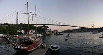
Istanbul's primary motorways are the O-1, O-2, O-3 and O-4. The O-1 forms the city's inner ring road, traversing the 15 Temmuz Şehitler (First Bosphorus) Bridge, and the O-2 is the city's outer ring road, crossing the Fatih Sultan Mehmet (Second Bosphorus) Bridge. The O-2 continues west to Edirne and the O-4 continues east to Ankara; the O-2, O-3, and O-4 are part of European route E80 (the Trans-European Motorway) between Portugal and the Turkish–Iranian border.[326] In 2011, the first and second bridges on the Bosphorus carried 400,000 vehicles each day.[327] The Yavuz Sultan Selim (Third Bosphorus) Bridge entered service on 26 August 2016.[328] Environmentalist groups worry that the third bridge will endanger the remaining green areas to the north of Istanbul.[329][330] Apart from the three Bosphorus Bridges, the dual-deck, 14.6-kilometer (9.1 mi) Eurasia Tunnel (which entered service on 20 December 2016) under the Bosphorus strait also provides road crossings for motor vehicles between the Asian and European sides of Turkey.[331]
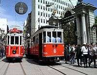
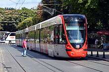
Istanbul's local public transportation system is a network of trams, funiculars, metro lines, buses, bus rapid transit, and ferries. Fares across modes are integrated, using the contactless Istanbulkart, introduced in 2009, or the older Akbil electronic ticket device.[332] Trams in Istanbul date back to 1872, when they were horse-drawn, but even the first electrified trams were decommissioned in the 1960s.[333] Operated by Istanbul Electricity, Tramway, and Tunnel General Management (İETT), trams slowly returned to the city in the 1990s with the introduction of a nostalgic route and a faster modern tram line, which now carries 265,000 passengers each day.[333][334] The Tünel opened in 1875 as the world's second-oldest subterranean rail line (after London's Metropolitan Railway).[333] It still carries passengers between Karaköy and İstiklal Avenue along a steep 573-meter (1,880 ft) track; a more modern funicular between Taksim Square and Kabataş began running in 2006.[335][336]
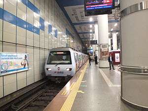
The Istanbul Metro comprises five lines (the M1, M2, M3 and M6 on the European side, and the M4 on the Asian side) with several other lines (such as the M5, M7, and M8) and extensions under construction.[337][338] The two sides of Istanbul's metro are connected under the Bosphorus by the Marmaray tunnel, inaugurated in 2013 as the first rail connection between Thrace and Anatolia.[339] With the Marmaray's completion, rail use in the city is expected to increase to 28 percent (from 4 percent), behind only Tokyo and New York City.[340] Until then, buses provide transportation within and between the two halves of the city, accommodating 2.2 million passenger trips each day.[341] The Metrobus, a form of bus rapid transit, crosses the Bosphorus Bridge, with dedicated lanes leading to its termini.[342] İDO (Istanbul Seabuses) runs a combination of all-passenger ferries and car-and-passenger ferries to ports on both sides of the Bosphorus, as far north as the Black Sea.[343][344] With additional destinations around the Sea of Marmara, İDO runs the largest municipal ferry operation in the world.[345] The city's main cruise ship terminal is the Port of Istanbul in Karaköy, with a capacity of 10,000 passengers per hour.[346] Most visitors enter Istanbul by air, but about half a million foreign tourists enter the city by sea each year.[229]
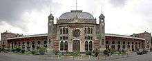
International rail service from Istanbul launched in 1889, with a line between Bucharest and Istanbul's Sirkeci Terminal, which ultimately became famous as the eastern terminus of the Orient Express from Paris.[82] Regular service to Bucharest and Thessaloniki continued until the early 2010s, when the former was interrupted for Marmaray construction and the latter was halted due to economic problems in Greece.[347][348] After Istanbul's Haydarpaşa Terminal opened in 1908, it served as the western terminus of the Baghdad Railway and an extension of the Hejaz Railway; today, neither service is offered directly from Istanbul.[349][350][351] Service to Ankara and other points across Turkey is normally offered by Turkish State Railways, but the construction of Marmaray and the Ankara-Istanbul high-speed line forced the station to close in 2012.[352] New stations to replace both the Haydarpaşa and Sirkeci terminals, and connect the city's disjointed railway networks, are expected to open upon completion of the Marmaray project; until then, Istanbul is without intercity rail service.[352] Private bus companies operate instead. Istanbul's main bus station is the largest in Europe, with a daily capacity of 15,000 buses and 600,000 passengers, serving destinations as distant as Frankfurt.[353][354]
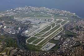
Istanbul has two international airports. The larger is Istanbul Atatürk, 24 kilometers (15 mi) west of the city center. It handled 61.3 million passengers in 2015, making it the third-busiest airport in Europe and the eighteenth-busiest in the world.[356] Sabiha Gökçen International, 45 kilometers (28 mi) southeast of the city center, opened in 2001 to relieve Atatürk. Dominated by low-cost carriers, Istanbul's second airport has rapidly become popular, especially since the opening of a new international terminal in 2009;[357] the airport handled 14.7 million passengers in 2012, a year after Airports Council International named it the world's fastest-growing airport.[358][359] Atatürk has also experienced rapid growth, as its 20.6 percent rise in passenger traffic between 2011 and 2012 was the highest among the world's top 30 airports.[356] Because of the traffic at Istanbul's current airports,[360] a third international airport is planned for the Black Sea coast.[361] Building a new runway at Atatürk Airport was rejected due to the cost involved;[360] environmental concerns have also been raised with respect to the new airport.[362] Currently under construction, the new international airport will become the largest airport in the world upon the completion of all four stages of the project, with a capacity to serve 150 million passengers per year.[363][364][365]
Sister and twin cities
See also
- Historic Areas of Istanbul, a World Heritage Site
Notes
- ↑ Where governor's office is located.
- 1 2 3 Sources have provided conflicting figures on the area of Istanbul. The most authoritative source on this figure ought to be the Istanbul Metropolitan Municipality (MMI), but the English version of its website suggests a few figures for this area. One page states that "Each MM is sub-divided into District Municipalities ("DM") of which there are 27 in Istanbul" [emphasis added] with a total area of 1,538.9 square kilometers (594.2 sq mi).[93] The Municipal History page appears to be the most explicit and most updated, saying that in 2004, "Istanbul Metropolitan Municipality's jurisdiction was enlarged to cover all the area within the provincial limits". It also states a 2008 law merged the Eminönü district into the Fatih district (a point that is not reflected in the previous source) and increased the number of districts in Istanbul to 39.[94] That total area, as corroborated on the Turkish version of the MMI website,[95] and a Jurisdiction page on the English site[96] is 5,343 square kilometers (2,063 sq mi).
- ↑ The foundation of Byzantion (Byzantium) is sometimes, especially in encyclopedic or other tertiary sources, placed firmly in 667 BCE. Historians have disputed the precise year the city was founded. Commonly cited is the work of 5th-century-BC historian Herodotus, which says the city was founded seventeen years after Chalcedon,[43] which came into existence around 685 BCE. Eusebius concurs with 685 BCE as the year Chalcedon was founded, but places Byzantion's establishment in 659 BCE.[44] Among more modern historians, Carl Roebuck proposed the 640s BCE[45] and others have suggested even later. The foundation date of Chalcedon is itself subject to some debate; while many sources place it in 685 BC,[46] others put it in 675 BC[47] or even 639 BCE (with Byzantion's establishment placed in 619 BCE).[44] Some sources refer to Byzantium's foundation as the 7th century BCE.
- 1 2 Historians disagree—sometimes substantially—on population figures of Istanbul (Constantinople), and other world cities, prior to the 20th century. A follow-up to Chandler & Fox 1974,Chandler 1987, pp. 463–505[79] examines different sources' estimates and chooses the most likely based on historical conditions; it is the source of most population figures between 100 and 1914. The ranges of values between 500 and 1000 are due to Morris 2010, which also does a comprehensive analysis of sources, including Chandler (1987); Morris notes that many of Chandler's estimates during that time seem too large for the city's size, and presents smaller estimates. Chandler disagrees with Turan 2010 on the population of the city in the mid-1920s (with the former suggesting 817,000 in 1925), but Turan, p. 224, is used as the source of population figures between 1924 and 2005. Turan's figures, as well as the 2010 figure,[171] come from the Turkish Statistical Institute. The drastic increase in population between 1980 and 1985 is largely due to an enlargement of the city's limits (see the Administration section). Explanations for population changes in pre-Republic times can be inferred from the History section.
- ↑ The United Nations defines an urban agglomeration as "the population contained within the contours of a contiguous territory inhabited at urban density levels without regard to administrative boundaries". The agglomeration "usually incorporates the population in a city or town plus that in the suburban areas lying outside of, but being adjacent to, the city boundaries".[177][178]
- ↑ UEFA does not apparently keep a list of Category 4 stadiums, but regulations stipulate that only these elite stadiums are eligible to host UEFA Champions League Finals,[270] which Atatürk Olympic Stadium did in 2005, and UEFA Europa League (formerly UEFA Cup) Finals,[271] which Şükrü Saracoğlu Stadium did in 2009. Türk Telekom Arena is noted as an elite UEFA stadium by its architects.[272]
References
- ↑ "City mayors:Largest cities in the world by land area, population and density". citymayors.com. Retrieved 26 June 2015.
- ↑ Brown, DR. Evrick (28 May 2014). Walking in the European City. ISBN 9781472416179.
- 1 2 3 "The Results of Address Based Population Registration System, 2017". Turkish Statistical Institute. 1 February 2018. Retrieved 1 February 2018.
- ↑ "Istanbul Fact Sheet" (PDF). www.istka.org.tr. ISTKA. Archived from the original on 20 April 2018. Retrieved 20 April 2018.
- ↑ "Sub-national HDI - Area Database - Global Data Lab". hdi.globaldatalab.org.
- ↑ Wells, John C. (2008), Longman Pronunciation Dictionary (3rd ed.), Longman, ISBN 9781405881180
- ↑ Roach, Peter (2011), Cambridge English Pronouncing Dictionary (18th ed.), Cambridge: Cambridge University Press, ISBN 9780521152532
- ↑ Merriam-Webster's Collegiate Dictionary, 11th Edition (Springfield, Mass., 2004), p. 1547.
- 1 2 3 WCTR Society; Unʼyu Seisaku Kenkyū Kikō 2004, p. 281
- ↑ Çelik 1993, p. xv
- 1 2 Masters & Ágoston 2009, pp. 114–5
- ↑ Dumper & Stanley 2007, p. 320
- 1 2 Turan 2010, p. 224
- 1 2 3 "Population and Demographic Structure". Istanbul 2010: European Capital of Culture. Istanbul Metropolitan Municipality. 2008. Retrieved 27 March 2012.
- 1 2 "MasterCard Global Destination Cities Index".
- ↑ "The World According to GaWC 2010". Globalization and World Cities (GaWC) Study Group and Network. Loughborough University. Retrieved 8 May 2012.
- ↑ Berube, Alan (1 December 2010). "Global Growth on the Orient Express". Brookings Institution blog "The Avenue". Retrieved 14 April 2013.
- 1 2 3 4 5 6 OECD Territorial Reviews: Istanbul, Turkey. Policy Briefs. The Organisation for Economic Co-operation and Development. March 2008. ISBN 978-92-64-04383-1.
- ↑ "IOC selects three cities as Candidates for the 2020 Olympic Games". The International Olympic Committee. 24 May 2012. Retrieved 18 June 2012.
- 1 2 3 4 Room 2006, pp. 177
- ↑ Georgacas 1947, p. 352ff.
- ↑ Gregory 2010, pp. 62–3
- ↑ Necipoğlu 2010, p. 262
- 1 2 Masters & Ágoston 2009, p. 286
- ↑ Masters & Ágoston 2009, pp. 226–7
- ↑ Finkel 2005, pp. 57, 383
- ↑ Necdet Sakaoğlu (1993/94a): "İstanbul'un adları" ["The names of Istanbul"]. In: Dünden bugüne İstanbul ansiklopedisi, ed. Türkiye Kültür Bakanlığı, Istanbul.
- ↑ "Online Etymology Dictionary". Retrieved 26 June 2015.
- ↑ Necdet Sakaoğlu (1993/94a): "İstanbul'un adları" ["The names of Istanbul"]. In: 'Dünden bugüne İstanbul ansiklopedisi', ed. Türkiye Kültür Bakanlığı, Istanbul.
- ↑ Room 2006, pp. 177–8
- ↑ Göktürk, Soysal & Türeli 2010, p. 7
- ↑ Göksel & Kerslake 2005, p. 27
- ↑ Keyder 1999, p. 95
- ↑ Rainsford, Sarah (10 January 2009). "Istanbul's ancient past unearthed". BBC. Retrieved 21 April 2010.
- ↑ Algan, O.; Yalçın, M. N. K.; Özdoğan, M.; Yılmaz, Y. C.; Sarı, E.; Kırcı-Elmas, E.; Yılmaz, İ.; Bulkan, Ö.; Ongan, D.; Gazioğlu, C.; Nazik, A.; Polat, M. A.; Meriç, E. (2011). "Holocene coastal change in the ancient harbor of Yenikapı–İstanbul and its impact on cultural history". Quaternary Research. 76: 30. Bibcode:2011QuRes..76...30A. doi:10.1016/j.yqres.2011.04.002.
- ↑ BBC: "Istanbul's ancient past unearthed" Published on 10 January 2007. Retrieved on 3 March 2010.
- ↑ "Bu keşif tarihi değiştirir". hurriyet.com.tr.
- ↑ "Marmaray kazılarında tarih gün ışığına çıktı". fotogaleri.hurriyet.com.tr.
- ↑ "Cultural Details of Istanbul". Republic of Turkey, Minister of Culture and Tourism. Archived from the original on 12 September 2007. Retrieved 2 October 2007.
- ↑ Janin, Raymond (1964). Constantinople byzantine. Paris: Institut Français d'Études Byzantines. p. 10f.
- ↑ Pliny the Elder, book IV, chapter XI:
"On leaving the Dardanelles we come to the Bay of Casthenes, ... and the promontory of the Golden Horn, on which is the town of Byzantium, a free state, formerly called Lygos; it is 711 miles from Durazzo, ..." Archived 1 January 2017 at the Wayback Machine. - ↑ Bloom & Blair 2009, p. 1
- ↑ Herodotus Histories 4.144, translated in De Sélincourt 2003, p. 288
- 1 2 Isaac 1986, p. 199
- ↑ Roebuck 1959, p. 119, also as mentioned in Isaac 1986, p. 199
- ↑ Lister 1979, p. 35
- ↑ Freely 1996, p. 10
- ↑ Çelik 1993, p. 11
- ↑ De Souza 2003, p. 88
- ↑ Freely 1996, p. 20
- ↑ Freely 1996, p. 22
- ↑ Grant 1996, pp. 8–10
- ↑ Limberis 1994, pp. 11–2
- ↑ Barnes 1981, p. 77
- ↑ Barnes 1981, p. 212
- 1 2 Barnes 1981, p. 222
- 1 2 3 Gregory 2010, p. 63
- 1 2 Klimczuk & Warner 2009, p. 171
- ↑ Dash, Mike (2 March 2012). "Blue Versus Green: Rocking the Byzantine Empire". Smithsonian Magazine. The Smithsonian Institution. Retrieved 30 July 2012.
- ↑ Dahmus 1995, p. 117
- ↑ Cantor 1994, p. 226
- ↑ Morris 2010, pp. 109–18
- ↑ Gregory 2010, pp. 324–9
- ↑ Gregory 2010, pp. 330–3
- ↑ Gregory 2010, p. 340
- ↑ Gregory 2010, pp. 341–2
- ↑ Reinert 2002, pp. 258–60
- ↑ Baynes 1949, p. 47
- ↑ Gregory 2010, pp. 394–9
- ↑ Béhar 1999, p. 38; Bideleux & Jeffries 1998, p. 71.
- ↑ Inalcik, Halil. "The Policy of Mehmed II toward the Greek Population of Istanbul and the Byzantine Buildings of the City." Dumbarton Oaks Papers 23, (1969): 229–249. p. 236
- ↑ Müller-Wiener, Wolfgang (1977). Bildlexikon zur Topographie Istanbuls: Byzantion, Konstantinupolis, Istanbul bis zum Beginn d. 17 Jh (in German). Tübingen: Wasmuth. ISBN 978-3-8030-1022-3.
- ↑ Müller-Wiener (1977), p. 28
- ↑ Holt, Lambton & Lewis 1977, pp. 306–7
- ↑ Joseph Patrick Byrne, Encyclopedia of the Black Death, Volume 1, p.87
- 1 2 Holt, Lambton & Lewis 1977, pp. 307
- ↑ Tarasov & Milner-Gulland 2004, p. 121; El-Cheikh 2004, p. 22.
- ↑ Holt, Lambton & Lewis 1977, pp. 735–6
- 1 2 Chandler, Tertius; Fox, Gerald (1974). "3000 Years of Urban Growth". London: Academic Press. ISBN 978-0-12-785109-9.
- ↑ Shaw & Shaw 1977, pp. 4–6, 55
- ↑ Çelik 1993, pp. 87–9
- 1 2 Harter 2005, p. 251
- ↑ Shaw & Shaw 1977, pp. 230, 287, 306
- ↑ "Meclis-i Mebusan (Mebuslar Meclisi)". Tarihi Olaylar.
- ↑ Çelik 1993, p. 31
- ↑ Freedman, Jeri (2009). The Armenian genocide (1st ed.). New York: Rosen Pub. Group. pp. 21–2. ISBN 978-1404218253.
- ↑ Globalization, Cosmopolitanism, and the Dönme in Ottoman Salonica and Turkish Istanbul. Marc Baer, University of California, Irvine.
- 1 2 "6 Ekim İstanbul'un Kurtuluşu". Sözcü. 6 October 2017.
- ↑ Landau 1984, p. 50
- ↑ Dumper & Stanley 2007, p. 39
- ↑ Keyder 1999, pp. 11–2, 34–6
- ↑ Efe & Cürebal 2011, pp. 718–9
- ↑ "Districts". Istanbul Metropolitan Municipality. Retrieved 21 December 2011.
- 1 2 3 "History of Local Governance in Istanbul". Istanbul Metropolitan Municipality. Retrieved 21 December 2011.
- ↑ "İstanbul İl ve İlçe Alan Bilgileri" [Istanbul Province and District Area Information] (in Turkish). Istanbul Metropolitan Municipality. Retrieved 20 June 2010.
- ↑ "Jurisdiction". Istanbul Metropolitan Municipality. Retrieved 21 December 2011.
- ↑ "Istanbul from a Bird's Eye View". Governorship of Istanbul. Archived from the original on 17 May 2009. Retrieved 13 June 2010.
- 1 2 "The Topography of İstanbul". Republic of Turkey Ministry of Culture and Tourism. Retrieved 19 June 2012.
- ↑ Revkin, Andrew C. (24 February 2010). "Disaster Awaits Cities in Earthquake Zones". The New York Times. Retrieved 13 June 2010.
- ↑ Parsons, Tom; Toda, Shinji; Stein, Ross S.; Barka, Aykut; Dieterich, James H. (2000). "Heightened Odds of Large Earthquakes Near Istanbul: An Interaction-Based Probability Calculation" (Submitted manuscript). Science. Washington, D.C. 288 (5466): 661–5. Bibcode:2000Sci...288..661P. doi:10.1126/science.288.5466.661. PMID 10784447.
- ↑ Traynor, Ian (9 December 2006). "A Disaster Waiting to Happen – Why a Huge Earthquake Near Istanbul Seems Inevitable". The Guardian. UK. Retrieved 13 June 2010.
- ↑ Kottek, Markus; Grieser, Jürgen; Beck, Christoph; Rudolf, Bruno; Rube, Franz (June 2006). "World Map of the Köppen-Geiger climate classification updated" (PDF). Meteorologische Zeitschrift. 15 (3): 259–263. Bibcode:2006MetZe..15..259K. doi:10.1127/0941-2948/2006/0130. Retrieved 29 March 2013.
- ↑ Peel, M. C.; Finlayson, B. L.; McMahon, T. A. (2007). "Updated world map of the Köppen-Geiger climate classification" (PDF). Hydrology and Earth System Sciences. 4 (2): 439–473. doi:10.5194/hessd-4-439-2007. Retrieved 29 March 2013.
- ↑ "Total Participation Data: August" (in Turkish). Turkish State Meteorological Service. Archived from the original on 16 May 2012. Retrieved 6 July 2012.
- 1 2 Efe & Cürebal 2011, pp. 716–7
- ↑ "COMPARISONS OF ANNUAL MEANPRECIPITATION GRIDDED AND STATION DATA: AN EXAMPLE FROM ISTANBUL, TURKEY Yıllık Ortalama Gridlenmiş Yağış Verisi ve İstasyon Yağış Verisinin Karşılaştırılması, İstanbul Örneği – USTAOĞLU – Marmara Coğrafya Dergisi". marmara.edu.tr. Retrieved 12 February 2016.
- ↑ belgrat. "HÜSNÜ YAZICI YAZDIĞI KONULAR". blogspot.com.tr. Retrieved 12 February 2016.
- 1 2 "Weather – Istanbul". World Weather. BBC Weather Centre. Retrieved 15 October 2012.
- ↑ "Istanbul Enshrouded in Dense Fog". Turkish Daily News. 14 January 2005. Retrieved 15 October 2012.
- ↑ "Thick Fog Causes Disruption, Flight Delays in İstanbul". Today's Zaman. 23 November 2009. Archived from the original on 4 November 2013. Retrieved 15 October 2012.
- ↑ "Dense Fog Disrupts Life in Istanbul". Today's Zaman. 6 November 2010. Archived from the original on 4 November 2013. Retrieved 15 October 2012.
- 1 2 Pelit, Attila. "When to Go to Istanbul". TimeOut Istanbul. Archived from the original on 14 December 2011. Retrieved 19 December 2011.
- 1 2 3 "Resmi İstatistikler (İl ve İlçelerimize Ait İstatistiki Veriler)" [Official Statistics (Statistical Data of Provinces and Districts) – Istanbul] (in Turkish). Turkish State Meteorological Service. Retrieved 10 August 2015.
- ↑ Quantic 2008, p. 155
- ↑ Kindap, Tayfin (19 January 2010). "A Severe Sea-Effect Snow Episode Over the City of Istanbul". Natural Hazards. 54 (3): 703–23. doi:10.1007/s11069-009-9496-7. ISSN 1573-0840. Retrieved 15 October 2012.
- ↑ "Istanbul Winds Battle Over the City". Turkish Daily News. 17 October 2009. Retrieved 15 October 2012.
- ↑ "Yıllık Toplam Yağış Verileri" [Annual Total Participation Data: Istanbul, Turkey] (in Turkish). Turkish State Meteorological Service. Retrieved 6 July 2012.
- ↑ "İstanbul Bölge Müdürlüğü'ne Bağlı İstasyonlarda Ölçülen Ekstrem Değerler" [Extreme Values Measured in Istanbul Regional Directorate] (PDF) (in Turkish). Turkish State Meteorological Service. Archived from the original (PDF) on 24 May 2011. Retrieved 27 July 2010.
- ↑ Tayanç, Mete; Karaca, Mehmet; Dalfes, H. Nüzhet (1998). "March 1987 Cyclone (Blizzard) over the Eastern Mediterranean and Balkan Region Associated with Blocking". Monthly Weather Review. 126 (11): 3036. Bibcode:1998MWRv..126.3036T. doi:10.1175/1520-0493(1998)126<3036:MCBOTE>2.0.CO;2. Retrieved 27 July 2010.
- ↑ "Resmi İstatistikler (İl ve İlçelerimize Ait İstatistiki Veriler)" [Official Statistics (Statistical Data of Provinces and Districts) – Istanbul] (in Turkish). Turkish State Meteorological Service. Archived from the original on 22 April 2018. Retrieved 22 April 2018.
- ↑ "The Yearly Measurements by Kirecburnu Station Between 1990–1999" (PDF).
- ↑ "The Yearly Measurements by Bahcekoy Station Between 1990–1999" (PDF).
- ↑ "Istanbul, Turkey - Climate data". Weather Atlas. Archived from the original on 30 March 2017. Retrieved 29 March 2017.
- ↑ "Turkey reeling from African heat wave". Daily Sabah. 2 July 2017.
- ↑ "Gov't forced to take measures amid below average rainfall across Turkey". Hürriyet Daily News. 21 January 2018.
- ↑ "Lightning electrifies Istanbul, northwestern Turkey skies as thunderstorms take over". Daily Sabah. 24 July 2018.
- ↑ "Istanbul flood result of Turkey's climate change". ANADOLU AGENCY. 27 July 2017.
- ↑ ŞEN, ÖMER LÜTFİ. "CLIMATE CHANGE IN TURKEY". MERCATOR-IPC FELLOWSHIP PROGRAM. Retrieved 27 September 2018.
- ↑ "Temperature to increase significantly in Turkey in 30 years due to global warming, warns climate expert". Hürriyet Daily News. 19 March 2018.
- ↑ Çetin, Nefise; Mansuroğlu, Sibel; Kalaycı Önaç, Ayşe. "Xeriscaping Feasibility as an Urban Adaptation Method for Global Warming: A Case Study from Turkey". Pol. J. Environ. Stud. 27 (3): 1009–1018. Retrieved 27 September 2018.
- ↑ "İstanbul Climate Change Action Plan Preparation Project". Retrieved 27 September 2018.
- ↑ Çelik 1993, pp. 70, 169
- ↑ Çelik 1993, p. 127
- ↑ Moonan, Wendy (29 October 1999). "For Turks, Art to Mark 700th Year". The New York Times. Retrieved 4 July 2012.
- ↑ Oxford Business Group 2009, p. 105
- ↑ Karpat 1976, pp. 78–96
- ↑ Yavuz, Ercan (8 June 2009). "Gov't launches plan to fight illegal construction". Today's Zaman. Archived from the original on 20 January 2012. Retrieved 20 December 2011.
- ↑ Rowland Atkinson; Gary Bridge (2005). Gentrification In A Global Context: The New Urban Colonialism. Routledge. pp. 123–. ISBN 978-0-415-32951-4. Retrieved 6 May 2013.
- ↑ Jessica Bourque (4 July 2012). "Poor but Proud Istanbul Neighborhood Faces Gentrification". The New York Times. Retrieved 6 May 2013.
- ↑ Robert Tait (22 July 2008). "Forced gentrification plan spells end for old Roma district in Istanbul". The Guardian. Retrieved 6 May 2013.
- ↑ "New city construction to begin in six months". Hurriyet Daily News. 22 February 2013. Retrieved 6 May 2013.
- ↑ Boyar & Fleet 2010, p. 247
- ↑ Taylor 2007, p. 241
- ↑ "Water Supply Systems, Reservoirs, Charity and Free Fountains, Turkish Baths". Republic of Turkey Ministry of Culture and Tourism. Archived from the original on 19 November 2010. Retrieved 29 April 2012.
- ↑ Time Out Guides 2010, p. 212
- ↑ "Continuity and Change in Nineteenth-Century Istanbul: Sultan Abdulaziz and the Beylerbeyi Palace", Filiz Yenisehirlioglu, Islamic Art in the 19th Century: Tradition, Innovation, And Eclecticism, 65.
- 1 2 Chamber of Architects of Turkey 2006, pp. 80, 118
- ↑ "Blue Mosque". bluemosque.co. Retrieved 12 June 2014.
- ↑ Chamber of Architects of Turkey 2006, p. 176
- ↑ Gregory 2010, p. 138
- ↑ Freely 2000, p. 283
- ↑ Necipoğlu 1991, pp. 180, 136–137
- ↑ Çelik 1993, p. 159
- ↑ Çelik 1993, pp. 133–34, 141
- ↑ "Büyükşehir Belediyesi Kanunu" [Metropolitan Municipal Law]. Türkiye Büyük Millet Meclisi (in Turkish). 10 July 2004. Retrieved 30 November 2010.
Bu Kanunun yürürlüğe girdiği tarihte; büyükşehir belediye sınırları, İstanbul ve Kocaeli ilinde, il mülkî sınırıdır. (On the date this law goes in effect, the metropolitan city boundaries, in the provinces of İstanbul and Kocaeli, are those of the province.)
- ↑ Gül 2012, pp. 43–9
- ↑ Çelik 1993, pp. 42–8
- ↑ Kapucu & Palabiyik 2008, p. 145
- ↑ Taşan-Kok 2004, p. 87
- ↑ Wynn 1984, p. 188
- ↑ Taşan-Kok 2004, pp. 87–8
- 1 2 Kapucu & Palabiyik 2008, pp. 153–5
- ↑ Erder, Sema (November 2009). "Local Governance in Istanbul" (PDF). Istanbul: City of Intersections. Urban Age. London: 46. Retrieved 16 July 2012.
- 1 2 Kapucu & Palabiyik 2008, p. 156
- 1 2 "Metropolitan Executive Committee". Istanbul Metropolitan Municipality. Archived from the original on 2 January 2012. Retrieved 21 December 2011.
- ↑ Kapucu & Palabiyik 2008, pp. 155–6
- ↑ "The Mayor". Istanbul Metropolitan Municipality. Retrieved 12 July 2018.
- ↑ "Organizasyon" [Organization] (in Turkish). Istanbul Special Provincial Administration. Archived from the original on 26 November 2011. Retrieved 21 December 2011.
- ↑ Organisation for Economic Co-operation and Development 2008, p. 206
- ↑ "Governor of Istanbul". Governorship of Istanbul. Retrieved 12 July 2018.
- ↑ "Address Based Population Registration System Results of 2010" (doc). Turkish Statistical Institute. 28 January 2011. Retrieved 24 December 2011.
- ↑ Morris 2010, p. 113
- ↑ Chandler 1987, pp. 463–505
- ↑ "2007 statistics". tuik. Archived from the original on 3 November 2012.
- ↑ "1980 Statistics". tuik. Archived from the original on 3 November 2012.
- ↑ "Istanbul Asian and European population details" (in Turkish). 2013. Archived from the original on 2 February 2009. Retrieved 16 June 2015.
İstanbul'da 8 milyon 156 bin 696 kişi Avrupa, 4 milyon 416 bin 867 vatandaş da Asya yakasında bulunuyor (In Istanbul there are 8,156,696 people in Europe, 4,416,867 citizens in Asia)
- ↑ "Frequently Asked Questions". World Urbanization Prospects, the 2011 Revision. The United Nations. 5 April 2012. Archived from the original on 7 September 2012. Retrieved 20 September 2012.
- ↑ "File 11a: The 30 Largest Urban Agglomerations Ranked by Population Size at Each Point in Time, 1950-2035" (xls). World Urbanization Prospects, the 2018 Revision. The United Nations. 5 April 2012. Retrieved 21 August 2018.
- ↑ Kamp, Kristina (17 February 2010). "Starting Up in Turkey: Expats Getting Organized". Today's Zaman. Archived from the original on 9 May 2013. Retrieved 27 March 2012.
- 1 2 "Social Structure Survey 2006". KONDA Research. 2006. Retrieved 27 March 2012. (Note: Accessing KONDA reports directly from KONDA's own website requires registration.)
- ↑ U.S. Bureau of Democracy, Human Rights, and Labor. "Turkey: International Religious Freedom Report 2007". U.S. Department of State. Retrieved 27 March 2012.
- ↑ "History of the Ecumenical Patriarch". The Ecumenical Patriarch of Constantinople. Archived from the original on 8 June 2012. Retrieved 20 June 2012.
- ↑ "The Patriarchal Church of Saint George". The Ecumenical Patriarch of Constantinople. Archived from the original on 31 May 2012. Retrieved 20 June 2012.
- ↑ Çelik 1993, p. 38
- ↑ Athanasopulos 2001, p. 82
- ↑ "The Greek Minority and its foundations in Istanbul, Gokceada (Imvros) and Bozcaada (Tenedos)". Hellenic Republic Ministry of Foreign Affairs. 21 March 2011. Archived from the original on 26 July 2012. Retrieved 21 June 2012.
- ↑ "Istanbul Population 2015". World Population Review. 7 July 2015.
- ↑ Masters & Ágoston 2009, pp. 520–1
- ↑ Wedel 2000, p. 182
- ↑ Amikam Nachmani (2003). Turkey: Facing a New Millenniium : Coping With Intertwined Conflicts. Manchester University Press. pp. 90–. ISBN 978-0-7190-6370-1. Retrieved 5 May 2013.
- ↑ Milliyet Konda Araştırma (2006). "Biz Kimiz: Toplumsal Yapı Araştırması" (PDF). Retrieved 4 May 2013.
- ↑ Agirdir, Bekir (2008). "Kürtler ve Kürt Sorunu" (PDF). KONDA. Retrieved 4 May 2013.
- ↑ Bekir Agirdir. "Kürtlerin nüfusu 11 milyonda İstanbul"da 2 milyon Kürt yaşıyor". Retrieved 4 May 2013.
- ↑ Christiane Bird (18 December 2007). A Thousand Sighs, A Thousand Revolts: Journeys in Kurdistan. Random House Publishing Group. pp. 308–. ISBN 978-0-307-43050-2. Retrieved 4 May 2013.
- ↑ Elma Gabela (5 June 2011). "Turkey's Bosniak communities uphold their heritage, traditions". Today's Zaman. Archived from the original on 23 August 2011. Retrieved 20 September 2011.
- ↑ Rôzen 2002, pp. 55–8, 49
- ↑ Rôzen 2002, pp. 49–50
- ↑ Brink-Danan 2011, p. 176
- ↑ ʻAner 2005, p. 367
- ↑ Schmitt 2005, passim
- ↑ "Going cold Turkey: African migrants in Istanbul see hopes turn sour". IRIN. Retrieved 23 February 2016.
- ↑ "Ruling AKP's demand for list of ballot box clerks raises election fraud concerns – POLITICS". hurriyetdailynews.com. Retrieved 12 February 2016.
- ↑ "Election protests in Turkey as opposition cries foul". Reuters.
- ↑ "Turkey's AKP Accused of Systemic Election Fraud Plots for Early Presidential and National Elections". nsnbc international. Archived from the original on 4 March 2016. Retrieved 12 February 2016.
- ↑ "Trouble in Turkey's Elections – Erik Meyersson". Erik Meyersson. Retrieved 12 February 2016.
- ↑ "Electoral Fraud Discovered in Sarıyer, Istanbul – Anadolu Türk Haber". anadoluturkhaber.com.
- ↑ "LiveLeak.com – TURKEY – Election FRAUD (VIDEO), burned non-AKP votes". liveleak.com.
- ↑ "Bloomberg Business". Bloomberg.com. Archived from the original on 6 June 2014.
- ↑ "İSTANBUL SEÇİM SONUÇLARI". haberler.com. Archived from the original on 5 March 2016. Retrieved 12 February 2016.
- ↑ "Global MetroMonitor". Brookings Institution. 30 November 2012. Archived from the original on 4 June 2013. Retrieved 13 April 2013.
- 1 2 "Presentation of Reference City: Istanbul". Urban Green Environment. 2001. Archived from the original on 17 January 2012. Retrieved 30 December 2011.
- ↑ Geromel, Ricardo (14 March 2013). "Forbes Top 10 Billionaire Cities – Moscow Beats New York Again". Forbes. Retrieved 27 July 2013.
- ↑ "Dış Ticaretin Lokomotifi İstanbul" [Istanbul is the Locomotive of Foreign Trade] (in Turkish). NTV-MSNBC. 13 February 2006. Archived from the original on 31 May 2013. Retrieved 28 March 2012.
- ↑ Bilgic, Taylan (5 April 2013). "Istanbul Opens New Bourse as Erdogan Seeks to Build Finance Hub". Bloomberg News. Retrieved 14 April 2013.
- ↑ Odabaşı, Attila; Aksu, Celal; Akgiray, Vedat (December 2004). "The Statistical Evolution of Prices on the Istanbul Stock Exchange" (Full text). The European Journal of Finance. London. 10 (6): 510–25. CiteSeerX 10.1.1.500.6930. doi:10.1080/1351847032000166931.
- ↑ "History of the Bank". The Ottoman Bank Archives and Research Centre. Archived from the original on 13 April 2012. Retrieved 28 March 2012.
- ↑ "Milestones in ISE History". Istanbul Stock Exchange. 2012. Archived from the original on 25 November 2009. Retrieved 28 March 2012.
- ↑ Mark Bentley; Benjamin Harvey (17 September 2012). "Istanbul Aims to Outshine Dubai With $2.6 Billion Bank Center". Bloomberg Markets Magazine. Retrieved 5 May 2013.
- ↑ Oxford Business Group 2009, p. 112
- ↑ Jones, Sam, and agencies (27 April 2011). "Istanbul's new Bosphorus canal 'to surpass Suez or Panama'". The Guardian. Retrieved 29 April 2012.
- ↑ Organisation for Economic Co-operation and Development 2008, p. 80
- ↑ "Ports of Turkey". Cerrahogullari T.A.S. Archived from the original on 6 September 2012. Retrieved 28 August 2012.
- ↑ Cavusoglu, Omer (March 2010). "Summary on the Haydarpasa Case Study Site" (PDF). Cities Programme. London School of Economics. Retrieved 3 April 2012.
- ↑ Zeybek, Hülya; Kaynak, Muhtesem (27–30 May 2008). "What Role for Turkish Ports in the Regional Logistics Supply Chains?" (PDF). International Conference on Information Systems and Supply Chain. Retrieved 28 August 2012.
- ↑ Organisation for Economic Co-operation and Development 2008, p. 82
- ↑ Organisation for Economic Co-operation and Development 2008, p. 143
- ↑ Organisation for Economic Co-operation and Development 2008, p. 81
- ↑ Kerimoğlu, Ebra; Ciraci, Hale. "Urban Tourism: An Analysis of Visitors to Istanbul" (PDF). Vienna University of Economics and Business. Retrieved 12 February 2016.
- 1 2 3 "Istanbul '10" (PDF). Turkey Tourism Market Research Reports. Istanbul Valuation and Consulting. 2010. Archived from the original (PDF) on 16 June 2012. Retrieved 29 March 2012. (n.b. Source indicates that the Topkapı Palace Museum and the Hagia Sophia together bring in 55 million TL, approximately $30 million in 2010, on an annual basis.)
- 1 2 "İstanbul – Archaeology Museum". Republic of Turkey Ministry of Culture and Tourism. Retrieved 19 April 2012.
- ↑ Göktürk, Soysal & Türeli 2010, p. 8
- ↑ Reisman 2006, p. 88
- ↑ Göktürk, Soysal & Türeli 2010, pp. 2–4
- 1 2 Göktürk, Soysal & Türeli 2010, pp. 221–3
- ↑ Göktürk, Soysal & Türeli 2010, pp. 223–4
- ↑ Hansen, Suzy (10 February 2012). "The Istanbul Art-Boom Bubble". The New York Times. Retrieved 19 April 2012.
- ↑ "İşte yeni İstanbul Modern". Hürriyet. 28 November 2017.
- ↑ Kate Brown (1 March 2018). "Istanbul Modern Closes Ahead of Renzo Piano's Multimillion-Dollar Revamp". Artnet News.
- ↑ "Istanbul Modern". Renzo Piano Building Workshop (RPBW Architects). Retrieved 21 May 2018.
- ↑ "Galataport". Arkitera. Retrieved 21 May 2018.
- ↑ Göktürk, Soysal & Türeli 2010, pp. 130–1
- ↑ Göktürk, Soysal & Türeli 2010, pp. 133–4
- ↑ Göktürk, Soysal & Türeli 2010, p. 146
- ↑ Göktürk, Soysal & Türeli 2010, p. 165
- ↑ Nikitin, Nikolaj (6 March 2012). "Golden Age for Turkish Cinema". Credit-Suisse. Retrieved 6 July 2012.
- ↑ Köksal 2012, pp. 24–5
- ↑ "History". The Istanbul Foundation for Culture and Arts. Archived from the original on 3 May 2011. Retrieved 13 April 2012.
- ↑ Gibbons, Fiachra (21 September 2011). "10 of the Best Exhibitions at the Istanbul Biennial". The Guardian. Retrieved 13 April 2012.
- ↑ Hensel, Michael; Sungurogl, Defne; Ertaş, Hülya, eds. (January–February 2010). "Turkey at the Threshold". Architectural Design. London. 80 (1). ISBN 978-0-470-74319-5.
- 1 2 Köse 2009, pp. 91–2
- ↑ Taşan-Kok 2004, p. 166
- ↑ Emeksiz, İpek (3 September 2010). "Abdi İpekçi Avenue to be new Champs Elysee". Hürriyet Daily News. Retrieved 28 April 2012.
- ↑ "Shopping in Singapore is Better than Paris". CNN. 6 January 2012. Archived from the original on 17 April 2012. Retrieved 28 April 2012.
- ↑ Schäfers, Marlene (26 July 2008). "Managing the Difficult Balance Between Tourism and Authenticity". Hürriyet Daily News. Retrieved 29 April 2012.
- ↑ Schillinger, Liesl (8 July 2011). "A Turkish Idyll Lost in Time". The New York Times. Retrieved 29 April 2012.
- ↑ Freely 2011, p. 429
- ↑ Keyder 1999, p. 34
- ↑ Kugel, Seth (17 July 2011). "The $100 Istanbul Weekend". The New York Times. Retrieved 29 April 2012.
- ↑ Knieling & Othengrafen 2009, pp. 228–34
- ↑ Tomasetti, Kathryn; Rutherford, Tristan (23 March 2012). "A Big Night Out in Istanbul – And a Big Breakfast the Morning After". The Guardian. Retrieved 29 April 2012.
- ↑ "Besiktas: The Black Eagles of the Bosporus". FIFA. Retrieved 8 April 2012.
- ↑ "Turkey – List of Champions". www.rsssf.com. RSSSF. Retrieved 31 May 2018.
- 1 2 "Galatasaray: The Lions of the Bosporus". FIFA. Retrieved 10 April 2012.
- ↑ "UEFA Champions League 2007/08 – History – Fenerbahçe". The Union of European Football Associations. 8 October 2011. Retrieved 10 April 2012.
- ↑ "Puan Durumu: 2015–2016 Sezonu 30. Hafta" [League Table: 2015–16 Season, Round 30] (in Turkish). Turkish Basketball Super League. Retrieved 6 June 2016.
- ↑ "List of Certified Athletics Facilities". The International Association of Athletics Federations. 1 January 2013. Retrieved 2 January 2013.
- ↑ "Istanbul to host 2020 Champions League final, Uefa confirms". The Independent. 24 May 2018. Retrieved 24 May 2018.
- ↑ "2008/09: Pitmen strike gold in Istanbul". The Union of European Football Associations. 20 May 2009. Archived from the original on 17 September 2013. Retrieved 10 April 2012.
- ↑ Aktaş, İsmail (14 March 2012). "Aşçıoğlu Sues Partners in Joint Project Over Ali Sami Yen Land". Hürriyet Daily News. Retrieved 3 July 2012.
- ↑ "Regulations of the UEFA European Football Championship 2010–12" (PDF). The Union of European Football Associations. p. 14. Retrieved 10 April 2012.
- ↑ "Regulations of the UEFA Europa League 2010/11" (PDF). The Union of European Football Associations. p. 17. Retrieved 10 April 2012.
- ↑ "Türk Telekom Arena Istanbul". 'asp' Architekten. Archived from the original on 26 April 2013. Retrieved 5 July 2012.
- ↑ "2010 FIBA World Championship Istanbul: Arenas". FIBA. Archived from the original on 3 June 2013. Retrieved 10 April 2012.
- ↑ "Istanbul – Arenas". FIBA. 2010. Archived from the original on 3 June 2013. Retrieved 29 June 2012.
- ↑ "Fenerbahce Ulker's new home, Ulker Sports Arena, opens". Euroleague Basketball. 24 January 2012. Retrieved 29 June 2012.
- ↑ Wilson, Stephen (2 September 2011). "2020 Olympics: Six cities lodge bids for the games". The Christian Science Monitor. Retrieved 29 June 2012.
- ↑ Richards, Giles (22 April 2011). "Turkey Grand Prix Heads for the Scrapyard Over $26m Price Tag". The Guardian. Retrieved 3 July 2012.
- ↑ "Events" (PDF). FIA World Touring Car Championship. 2012. Archived from the original on 16 June 2012. Retrieved 29 June 2012.
- ↑ "The Circuits". European Le Mans Series. 2012. Archived from the original on 7 July 2012. Retrieved 3 July 2012.
- ↑ "2000 Race Calendar". F1 Powerboat World Championship. 2000. Retrieved 8 January 2017.
- ↑ "Powerboat P1 – 2009 World Championship – Istanbul, Turkey". Supersport. 21 June 2009.
- ↑ "2012 Yarış Programı ve Genel Yarış Talimatı" [2012 Race Schedule and General Sailing Instructions] (in Turkish). The Istanbul Sailing Club. 2012. Archived from the original on 4 June 2012. Retrieved 3 July 2012.
- ↑ Turkish Daily News (23 August 2008). "Sailing Week Starts in Istanbul". Hürriyet Daily News. Retrieved 3 July 2012.
- ↑ "About Us". The Turkish Offshore Racing Club. 31 March 2012. Retrieved 3 July 2012.
- ↑ Brummett 2000, pp. 11, 35, 385–6
- 1 2 3 4 "Country Profile: Turkey" (PDF). The Library of Congress Federal Research Division. August 2008. Retrieved 8 May 2012.
- ↑ "Tiraj". Medyatava (in Turkish). 25 December 2016. Retrieved 25 December 2016.
- 1 2 "TRT – Radio". The Turkish Radio and Television Corporation. Archived from the original on 9 June 2011. Retrieved 8 May 2012.
- ↑ Time Out Guides 2010, p. 224
- ↑ "TRT – Television". The Turkish Radio and Television Corporation. Archived from the original on 14 August 2011. Retrieved 8 May 2012.
- ↑ Norris 2010, p. 184
- ↑ "Chris Morris". BBC. Retrieved 8 May 2012.
- ↑ "History". Istanbul University. 11 August 2011. Archived from the original on 13 November 2012. Retrieved 20 August 2012.
- ↑ "History". Istanbul Technical University. Archived from the original on 18 June 2012. Retrieved 4 July 2012.
- ↑ "University Profile: Istanbul Technical University, Turkey". Board of European Students of Technology. Archived from the original on 16 November 2011. Retrieved 30 March 2012.
- ↑ "State Universities". The Turkish Council of Higher Education. Archived from the original on 30 November 2011. Retrieved 30 March 2012.
- ↑ "About Marmara". Marmara University. Archived from the original on 30 June 2012. Retrieved 4 July 2012.
- 1 2 Doğramacı, İhsan (August 2005). "Private Versus Public Universities: The Turkish Experience" (DOC). 18th International Conference on Higher Education. Ankara. Retrieved 30 March 2012.
- ↑ "History of RC". Robert College. 2012. Retrieved 15 October 2012.
- ↑ "Private Universities". The Turkish Council of Higher Education. Archived from the original on 30 November 2011. Retrieved 30 March 2012.
- ↑ "Baraja nazır en akıllı kent". Hürriyet. 4 May 2013. Retrieved 5 May 2013.
- ↑ "Aecom expands role on $2.2bn Istanbul scheme". everythingturkish.com.au. EverythingTurkish. 5 September 2012. Archived from the original on 21 September 2016. Retrieved 31 August 2016.
- ↑ "2007 Yılına Ait Veriler" [Data for 2007] (in Turkish). Governorship of Istanbul. Archived from the original on 2 August 2011. Retrieved 30 March 2012.
- ↑ "Historique" [History] (in French). Galatasaray University. Archived from the original on 21 March 2012. Retrieved 30 March 2012.
- ↑ "Millî Eğitim Bakanlığı Anadolu Liseleri Yönetmeliği" [Ministry of Education Regulation on Anatolian High Schools] (in Turkish). Ministry of Education. 5 November 1999. Archived from the original on 15 June 2012. Retrieved 30 March 2012.
- ↑ "Galatasaray Lisesi". Galatasaray High School. Retrieved 4 July 2012.
- ↑ "The History of the Italian School". Liceo Italiano. Archived from the original on 20 January 2012. Retrieved 3 July 2012.
- ↑ "Principles of Education". Darüşşafaka High School. Archived from the original on 9 May 2012. Retrieved 6 July 2012.
- ↑ "Kabataş Erkek Lisesi" (in Turkish). Kabataş Erkek Lisesi. Archived from the original on 2 April 2012. Retrieved 31 March 2012.
- ↑ "KAL Uygulamalı Yabancı Dil Laboratuvarı" [KAL Applied Foreign Language Lab] (in Turkish). Kadıköy Anadolu Lisesi. Archived from the original on 20 June 2013. Retrieved 31 March 2012.
- 1 2 "Istanbul and the History of Water in Istanbul". Istanbul Water and Sewerage Administration. Archived from the original on 29 September 2007. Retrieved 11 March 2006.
- ↑ Tigrek & Kibaroğlu 2011, pp. 33–4
- ↑ "İSKİ Administration". Istanbul Water and Sewerage Administration. Archived from the original on 29 September 2007. Retrieved 31 March 2012.
- 1 2 3 "Silahtarağa Power Plant". SantralIstanbul. Archived from the original on 30 July 2012. Retrieved 31 March 2012.
- 1 2 "Short History of Electrical Energy in Turkey". Turkish Electricity Transmission Company. 2001. Archived from the original on 28 November 2009. Retrieved 5 July 2012.
- ↑ "Central Post Office". Emporis. Retrieved 4 April 2012.
- 1 2 3 4 "About Us | Brief History". The Post and Telegraph Organization. Retrieved 31 March 2012.
- ↑ Masters & Ágoston 2009, p. 557
- ↑ Shaw & Shaw 1977, p. 230
- 1 2 "About Türk Telekom: History". Türk Telekom. Retrieved 31 March 2012.
- ↑ Sanal 2011, p. 85
- ↑ Oxford Business Group 2009, p. 197
- ↑ Oxford Business Group 2009, p. 198
- ↑ Connell 2010, pp. 52–3
- ↑ Papathanassis 2011, p. 63
- ↑ Google (1 April 2012). "Istanbul Overview" (Map). Google Maps. Google. Retrieved 1 April 2012.
- ↑ Efe & Cürebal 2011, p. 720
- ↑ "3rd Bosphorus bridge opening ceremony". TRT World. 25 August 2016. Archived from the original on 28 August 2016.
- ↑ ERM Group (Germany and UK) and ELC-Group (Istanbul) (January 2011). "Volume I: Non Technical Summary (NTS)" (PDF). Eurasia Tunnel Environmental and Social Impact Assessment. The European Investment Bank. Retrieved 4 July 2012.
- ↑ Letsch, Constanze (8 June 2012). "Plan for New Bosphorus Bridge Sparks Row Over Future of Istanbul". The Guardian. Retrieved 4 July 2012.
- ↑ "Istanbul's $1.3BN Eurasia Tunnel prepares to open". Anadolu Agency. 19 December 2016.
- ↑ Songün, Sevim (16 July 2010). "Istanbul Commuters Skeptical of Transit Change". Hürriyet Daily News. Retrieved 5 July 2012.
- 1 2 3 "Chronological History of IETT" (PDF). Istanbul Electricity, Tramway and Tunnel General Management. Archived from the original on 16 June 2012. Retrieved 1 April 2012.
- ↑ "T1 Bağcılar–Kabataş Tramvay Hattı" [T1 Bağcılar–Kabataş Tram Line] (in Turkish). İstanbul Ulaşım A.Ş. (Istanbul Transport Corporation). Retrieved 20 August 2012.
- ↑ "Tunnel". Istanbul Electricity, Tramway and Tunnel. Archived from the original on 6 January 2012. Retrieved 3 April 2012. (Note: It is apparent this is a machine translation of the original.)
- ↑ "F1 Taksim–Kabataş Füniküler Hattı" [F1 Bağcılar–Kabataş Funicular Line] (in Turkish). İstanbul Ulaşım A.Ş. (Istanbul Transport Corporation). Retrieved 20 August 2012.
- ↑ "Raylı Sistemler" [Rail Systems] (in Turkish). İstanbul Ulaşım A.Ş. (Istanbul Transport Corporation). Retrieved 20 August 2012.
- ↑ "Ağ Haritaları" [Network Maps] (in Turkish). İstanbul Ulaşım A.Ş. (Istanbul Transport Corporation). Retrieved 20 August 2012.
- ↑ "Turkey: Connecting Continents". Economic Updates. Oxford Business Group. 7 March 2012. Retrieved 3 April 2012.
- ↑ Efe & Cürebal 2011, p. 723
- ↑ "Public Transportation in Istanbul". Istanbul Electricity, Tramway and Tunnel General Management. Archived from the original on 4 January 2013. Retrieved 3 April 2012.
- ↑ "Metrobus". Istanbul Electricity, Tramway and Tunnel General Management. Archived from the original on 6 October 2011. Retrieved 3 April 2012.
- ↑ "Interaktif Haritalar | İç Hatlar" [Interactive Map of Timetables | Inner-City Lines] (in Turkish). İDO. Archived from the original on 31 May 2012. Retrieved 3 April 2012.
- ↑ "Dış Hatlar" [Interactive Map of Timetables | Inter-City Lines] (PDF) (in Turkish). İDO. Archived from the original on 16 June 2012. Retrieved 3 April 2012.
- ↑ Grytsenko, Sergiy (26 September 2011). "EBRD Supports Privatisation of Ferry Operations in Istanbul". The European Bank for Reconstruction and Development. Archived from the original on 17 June 2013. Retrieved 4 April 2012.
- ↑ "Liman Hizmetleri" [Port Services] (in Turkish). Turkey Maritime Organization. 10 February 2011. Archived from the original on 16 October 2012. Retrieved 28 August 2012.
- ↑ "Bölgesel Yolcu Trenleri" [Regional Passenger Trains] (in Turkish). Turkish State Railways. Archived from the original on 4 April 2012. Retrieved 3 April 2012.
- ↑ Keenan, Steve (22 June 2012). "How Your Greek Summer Holiday Can Help Save Greece". The Guardian. Retrieved 28 September 2012.
- ↑ "Haydarpasa Train Station". Emporis. Retrieved 3 April 2012.
- ↑ Head, Jonathan (16 February 2010). "Iraq – Turkey railway link re-opens". BBC. Retrieved 3 April 2012.
- ↑ "Transports to Middle-Eastern Countries". Turkish National Railways. Archived from the original on 15 April 2012. Retrieved 3 April 2012.
- 1 2 Akay, Latifa (5 February 2012). "2012 Sees End of Line for Haydarpaşa Station". Today's Zaman. Archived from the original on 16 September 2013. Retrieved 3 April 2012.
- ↑ "İstanbul Otogarı" [Istanbul Bus Station] (in Turkish). Avrasya Terminal İşletmeleri A.Ş. (Eurasian Terminal Management, Inc.). Archived from the original on 20 April 2012. Retrieved 3 April 2012.
- ↑ "Eurolines Germany–Deutsche Touring GmbH–Europabus". Touring. Retrieved 3 April 2012.
- ↑ "2015 Airport Traffic Statistics". Airport Council International. 11 April 2016. Retrieved 7 June 2016.
- 1 2 "Preliminary 2013 World Airport Traffic and Rankings". Airports Council International. 17 March 2014. Retrieved 25 March 2014.
- ↑ Strauss, Delphine (25 November 2009). "Sabiha Gökçen: New Terminal Lands On Time and Budget". The Financial Times. Retrieved 4 July 2012.
- ↑ "Yolcu Trafiği (Gelen-Giden)" [Passenger Traffic (Incoming-Outgoing)] (PDF) (in Turkish). General Directorate of State Airports Authority. Retrieved 30 March 2013.
- ↑ "Sabiha Gökçen Named World's Fastest Growing Airport". Today's Zaman. 18 August 2011. Archived from the original on 16 September 2013. Retrieved 4 April 2012.
- 1 2 "'Third airport a must to ease air traffic in İstanbul'". Today's Zaman. 29 April 2012. Archived from the original on 4 November 2013. Retrieved 6 May 2013.
- ↑ Ozge Ozbilgin (3 May 2013). "Turkish firms win 22 billion euro Istanbul airport tender". Reuters. Retrieved 5 May 2013.
- ↑ "Consortium wins Istanbul airport tender for 22.1 billion euros". Hurriyet Daily News. 3 May 2013. Retrieved 6 May 2013.
- ↑ "It will be the biggest airport of the world". 24 January 2013. Retrieved 24 January 2013.
- ↑ Damien Sharkov (14 August 2014). "Istanbul's New Erdoğan-Backed Airport to Be Named After... Erdoğan". Newsweek. Retrieved 8 March 2016.
- ↑ "Erdogan Airport: Istanbul's Super Hub 'to be Named After Turkey's President-Elect'". International Business Times UK. Retrieved 12 February 2016.
Bibliography
- ʻAner, Nadav (2005). Pergola, Sergio Della; Gilboa, Amos; Ṭal, Rami, eds. The Jewish People Policy Planning Institute Planning Assessment, 2004–2005: The Jewish People Between Thriving and Decline. Jerusalem: Gefen Publishing House Ltd. ISBN 978-965-229-346-6.
- Athanasopulos, Haralambos (2001). Greece, Turkey, and the Aegean Sea: A Case Study in International Law. Jefferson, N.C.: McFarland & Company, Inc. ISBN 978-0-7864-0943-3.
- Barnes, Timothy David (1981). Constantine and Eusebius. Cambridge, Massachusetts: Harvard University Press. ISBN 978-0-674-16531-1.
- Baynes, Norman H. (1949). Baynes, Norman H.; Moss, Henry S. L. B, eds. Byzantium: An Introduction to East Roman Civilization. Oxford, Eng.: Clarendon Press. ISBN 978-0-674-16531-1.
- Béhar, Pierre (1999). Vestiges d'Empires: La Décomposition de l'Europe Centrale et Balkanique. Paris: Éditions Desjonquères. ISBN 978-2-84321-015-0.
- Bideleux, Robert; Jeffries, Ian (1998). A History of Eastern Europe: Crisis and Change. New York and London: Routledge. ISBN 978-0-415-16111-4.
- Boyar, Ebru; Fleet, Kate (2010). A Social History of Ottoman Istanbul. Cambridge, Eng.: Cambridge University Press. ISBN 978-0-521-13623-5.
- Bloom, Jonathan M.; Blair, Sheila (2009). The Grove Encyclopedia of Islamic Art and Architecture: Delhi to Mosque. Oxford University Press. p. 1. ISBN 978-0-19-530991-1. Retrieved 11 April 2013.
Whatever the prehistoric antecedents of Istanbul, the continuous historical development of the site began with the foundation of a Greek colony from Megara in the mid-7th century BCE...
- Brink-Danan, Marcy (2011). Jewish Life in Twenty-First-Century Turkey: The Other Side of Tolerance. New Anthropologies of Europe. Bloomington, Ind.: Indiana University Press. ISBN 978-0-253-35690-1.
- Brummett, Palmira Johnson (2000). Image and Imperialism in the Ottoman Revolutionary Press, 1908–1911. Albany, N.Y.: SUNY Press. ISBN 978-0-7914-4463-4.
- Cantor, Norman F. (1994). Civilization of the Middle Ages. New York: HarperCollins. ISBN 978-0-06-092553-6.
- Çelik, Zeynep (1993). The Remaking of Istanbul: Portrait of an Ottoman City in the Nineteenth Century. Berkeley, Calif., & Los Angeles: University of California Press. ISBN 978-0-520-08239-7.
- Chamber of Architects of Turkey (2006). Architectural Guide to Istanbul: Historic Peninsula. 1. Istanbul: Chamber of Architects of Turkey, Istanbul Metropolitan Branch. ISBN 978-975-395-899-8.
- Chandler, Tertius (1987). Four Thousand Years of Urban Growth: An Historical Census. Lewiston, N.Y.: St. David's University Press. ISBN 978-0-88946-207-6.
- Connell, John (2010). Medical Tourism. CAB Books. Wallingford, Eng.: CABI. ISBN 978-1-84593-660-0.
- Dahmus, Joseph (1995). A History of the Middle Ages. New York: Barnes & Noble Publishing. ISBN 978-0-7607-0036-5.
- De Sélincourt, Aubery (2003). Marincola, John M, ed. The Histories. Penguin Classics. London: Penguin Books. ISBN 978-0-14-044908-2.
- De Souza, Philip (2003). The Greek and Persian Wars, 499-386 B.C. London: Routledge. ISBN 978-0-415-96854-6.
- Dumper, Michael; Stanley, Bruce E., eds. (2007). Cities of the Middle East and North Africa: A Historical Encyclopedia. Santa Barbara, Calif.: ABC-CLIO. ISBN 978-1-57607-919-5.
- Efe, Recep; Cürebal, Isa (2011). "Impacts of the "Marmaray" Project (Bosphorus Tube Crossing, Tunnels, and Stations) on Transportation and Urban Environment in Istanbul". In Brunn, Stanley D. Engineering Earth: The Impacts of Megaengineering Projects. London & New York: Springer. pp. 715–34. ISBN 978-90-481-9919-8.
- El-Cheikh, Nadia Maria (2004). Byzantium Viewed by the Arabs. Cambridge, Massachusetts: Harvard University Press. ISBN 978-0-932885-30-2.
- Finkel, Caroline (2005). Osman's Dream: The Story of the Ottoman Empire, 1300–1923. New York: Basic Books. ISBN 978-0-465-02396-7.
- Freely, John (1996). Istanbul: The Imperial City. New York: Viking. ISBN 978-0-670-85972-6.
- Freely, John (2000). The Companion Guide to Istanbul and Around the Marmara. Woodbridge, Eng.: Companion Guides. ISBN 978-1-900639-31-6.
- Freely, John (2011). A History of Ottoman Architecture. Southampton, Eng.: WIT Press. ISBN 978-1-84564-506-9.
- Georgacas, Demetrius John (1947). "The Names of Constantinople". Transactions and Proceedings of the American Philological Association. 78: 347–67. doi:10.2307/283503. JSTOR 283503.
- Göksel, Aslı; Kerslake, Celia (2005). Turkish: A Comprehensive Grammar. Comprehensive Grammars. Abingdon, Eng.: Routledge. ISBN 978-0-415-21761-3.
- Göktürk, Deniz; Soysal, Levent; Türeli, İpek, eds. (2010). Orienting Istanbul: Cultural Capital of Europe?. New York: Routledge. ISBN 978-0-415-58011-3.
- Grant, Michael (1996). The Severans: The Changed Roman Empire. London: Routledge. ISBN 978-0-415-12772-1.
- Gregory, Timothy E. (2010). A History of Byzantium. Oxford, Eng.: John Wiley and Sons. ISBN 978-1-4051-8471-7.
- Gül, Murat (2012). The Emergence of Modern Istanbul: Transformation and Modernisation of a City (Revised Paperback ed.). London: IB.Tauris. ISBN 978-1780763743.
- Harter, Jim (2005). World Railways of the Nineteenth Century: A Pictorial History in Victorian Engravings (illustrated ed.). Baltimore: Johns Hopkins University Press. ISBN 978-0-8018-8089-6.
- Holt, Peter M.; Lambton, Ann K. S.; Lewis, Bernard, eds. (1977). The Cambridge History of Islam. 1A (illustrated, reprint ed.). Cambridge, Eng.: Cambridge University Press. ISBN 978-0-521-29135-4.
- Isaac, Benjamin H. (1986). The Greek Settlements in Thrace Until the Macedonian Conquest (illustrated ed.). Leiden, the Neth.: BRILL. ISBN 978-90-04-06921-3.
- Kapucu, Naim; Palabiyik, Hamit (2008). Turkish Public Administration: From Tradition to the Modern Age. USAK Publications. 17. Ankara: USAK. ISBN 978-605-4030-01-9.
- Karpat, Kemal H. (1976). The Gecekondu: Rural Migration and Urbanization (illustrated ed.). Cambridge, Eng.: Cambridge University Press. ISBN 978-0-521-20954-0.
- Keyder, Çağlar, ed. (1999). Istanbul: Between the Global and the Local. Lanham, Md.: Rowman & Littlefield. ISBN 978-0-8476-9495-2.
- King, Charles (2014). Midnight at the Pera Palace, The birth of modern Istanbul. Norton & Cy. ISBN 9780393089141-.
- Klimczuk, Stephen; Warner, Gerald (2009). Secret Places, Hidden Sanctuaries: Uncovering Mysterious Sights, Symbols, and Societies. New York: Sterling Publishing Company, Inc. ISBN 978-1-4027-6207-9.
- Knieling, Jörg; Othengrafen, Frank (2009). Planning Cultures in Europe: Decoding Cultural Phenomena in Urban and Regional Planning. Urban and Regional Planning and Development. Surrey, Eng.: Ashgate Publishing, Ltd. ISBN 978-0-7546-7565-5.
- Köksal, Özlem, ed. (2012). World Film Locations: Istanbul. Bristol, Eng.: Intellect Books. ISBN 978-1-84150-567-1.
- Köse, Yavuz (2009). "Vertical Bazaars of Modernity: Western Department Stores and Their Staff in Istanbul (1889–1921)". In Atabaki, Touraj; Brockett, Gavin. Ottoman and Republican Turkish Labour History. Cambridge, Eng.: Cambridge University Press. pp. 91–114. ISBN 978-0-521-12805-6.
- Landau, Jacob M. (1984). Atatürk and the Modernization of Turkey. Leiden, the Neth.: E.J. Brill. ISBN 978-90-04-07070-7.
- Limberis, Vasiliki (1994). Divine Heiress: The Virgin Mary and the Creation of Christian Constantinople. London: Routledge. ISBN 978-0-415-09677-5.
- Lister, Richard P. (1979). The Travels of Herodotus. London: Gordon & Cremonesi. ISBN 978-0-86033-081-3.
- Masters, Bruce Alan; Ágoston, Gábor (2009). Encyclopedia of the Ottoman Empire. New York: Infobase Publishing. ISBN 978-1-4381-1025-7.
- Morris, Ian (October 2010). Social Development (PDF). Stanford, Calif.: Stanford University. Archived from the original (PDF) on 15 September 2012. Retrieved 5 July 2012.
- Necipoğlu, Gülru (1991). Architecture, Ceremonial, and Power: The Topkapi Palace in the Fifteenth and Sixteenth Centuries. Cambridge, Massachusetts: The MIT Press. ISBN 978-0-262-14050-8.
- Necipoğlu, Gülru (2010). "From Byzantine Constantinople to Ottoman Kostantiniyye". In ölcer, Nazan. From Byzantion to Istanbul. Istanbul: SSM. ISBN 978-605-4348-04-6.
- Norris, Pippa (2010). Public Sentinel: News Media & Governance Reform. Washington, D.C.: World Bank Publications. ISBN 978-0-8213-8200-4.
- Organisation for Economic Co-operation and Development (2008). Istanbul, Turkey. OECD Territorial Reviews. Paris: OECD Publishing. ISBN 978-92-64-04371-8.
- Oxford Business Group (2009). The Report: Turkey 2009. Oxford, Eng.: Oxford Business Group. ISBN 978-1-902339-13-9.
- Papathanassis, Alexis (2011). The Long Tail of Tourism: Holiday Niches and Their Impact on Mainstream Tourism. Berlin: Springer. ISBN 978-3-8349-3062-0.
- Quantic, Roy (2008). Climatology for Airline Pilots. Oxford, Eng.: John Wiley & Sons. ISBN 978-0-470-69847-1.
- Reinert, Stephen W. (2002). "Fragmentation (1204–1453)". In Mango, Cyril. The Oxford History of Byzantium. Oxford, Eng.: Oxford University Press. ISBN 978-0-19-814098-6.
- Reisman, Arnold (2006). Turkey's Modernization: Refugees from Nazism and Atatürk's Vision. Washington, D.C.: New Academia Publishing, LLC. ISBN 978-0-9777908-8-3.
- Roebuck, Carl (1959). Ionian Trade and Colonization. Monographs on Archaeology and Fine Arts. New York: Archaeological Institute of America. ISBN 978-0-89005-528-1.
- Room, Adrian (2006). Placenames of the World: Origins and Meanings of the Names for 6,600 Countries, Cities, Territories, Natural Features, and Historic Sites (2nd ed.). Jefferson, N.C.: McFarland & Company. ISBN 978-0-7864-2248-7.
- Rôzen, Mînnā (2002). A History of the Jewish Community in Istanbul: The Formative Years, 1453–1566 (illustrated ed.). Leiden, the Neth.: BRILL. ISBN 978-90-04-12530-8.
- Sanal, Aslihan (2011). Fischer, Michael M. J.; Dumit, Joseph, eds. New Organs Within Us: Transplants and the Moral Economy. Experimental Futures (illustrated ed.). Chapel Hill, N.C.: Duke University Press. ISBN 978-0-8223-4912-9.
- Schmitt, Oliver Jens (2005). Levantiner: Lebenswelten und Identitäten einer ethnokonfessionellen Gruppe im osmanischen Reich im "langen 19. Jahrhundert" (in German). München: Oldenbourg. ISBN 978-3-486-57713-6.
- Shaw, Stanford J.; Shaw, Ezel K. (1977). History of the Ottoman Empire and Modern Turkey. 2. Cambridge, Eng.: Cambridge University Press. ISBN 978-0-521-29166-8.
- Tarasov, Oleg; Milner-Gulland, R. R. (2004). Icon and Devotion: Sacred Spaces in Imperial Russia. London: Reaktion. ISBN 978-1-86189-118-1.
- Taşan-Kok, Tuna (2004). Budapest, Istanbul, and Warsaw: Institutional and Spatial Change. Delft, the Neth.: Eburon Uitgeverij B.V. ISBN 978-90-5972-041-1.
- Taylor, Jane (2007). Imperial Istanbul: A Traveller's Guide: Includes Iznik, Bursa and Edirne. New York: Tauris Parke Paperbacks. ISBN 978-1-84511-334-6.
- Tigrek, Sahnaz; Kibaroğlu, Ayșegül (2011). "Strategic Role of Water Resources for Turkey". In Kibaroğlu, Ayșegül; Scheumann, Waltina; Kramer, Annika. Turkey's Water Policy: National Frameworks and International Cooperation. London & New York: Springer. ISBN 978-3-642-19635-5.
- Time Out Guides, ed. (2010). Time Out Istanbul. London: Time Out Guides. ISBN 978-1-84670-115-3.
- Turan, Neyran (2010). "Towards an Ecological Urbanism for Istanbul". In Sorensen, André; Okata, Junichiro. Megacities: Urban Form, Governance, and Sustainability. Library for Sustainable Urban Regeneration. London & New York: Springer. pp. 223–42. ISBN 978-4-431-99266-0.
- WCTR Society; Unʼyu Seisaku Kenkyū Kikō (2004). Urban Transport and the Environment: An International Perspective. Amsterdam: Elsevier. ISBN 978-0-08-044512-0.
- Wedel, Heidi (2000). Ibrahim, Ferhad; Gürbey, Gülistan, eds. The Kurdish Conflict in Turkey. Berlin: LIT Verlag Münster. pp. 181–93. ISBN 978-3-8258-4744-9.
- Wynn, Martin (1984). Planning and Urban Growth in Southern Europe. Studies in History, Planning, and the Environment. Los Altos, Calif.: Mansell. ISBN 978-0-7201-1608-3.
External links
- Official website of Istanbul
- Official website of the Istanbul Metropolitan Municipality
- Official website of the Istanbul Governorship
- Istanbul Metropolitan Municipality: Interactive aerial photos from 1946, 1966, 1970, 1982, 2006, 2011 and 2013
Coordinates: 41°00′49″N 28°57′18″E / 41.01361°N 28.95500°E
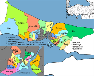