Şanlıurfa Province
| Şanlıurfa Province Şanlıurfa ili | |
|---|---|
| Province of Turkey | |
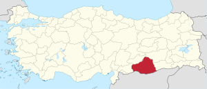 Location of Şanlıurfa Province in Turkey | |
| Country | Turkey |
| Region | Southeastern Anatolia |
| Subregion | Şanlıurfa |
| Government | |
| • Electoral district | Şanlıurfa |
| • Governor | Güngör Azim Tuna |
| Area | |
| • Total | 18,584 km2 (7,175 sq mi) |
| Population (2014)[1] | |
| • Total | 1,940,627 |
| • Density | 100/km2 (270/sq mi) |
| Area code(s) | 00414 |
| Vehicle registration | 63 |
Şanlıurfa Province (Turkish: Şanlıurfa ili) or simply Urfa Province is a province in southeastern Turkey. The city of Şanlıurfa is the capital of the province which bears its name. The population is 1,845,667 (2014).
The province is famous for its Abrahamic sites such as Balıklıgöl, where Prophet Abraham was cast by Nimrod into fire that is believed to have turned to water, and Mevlid-i Halil Mosque where Abraham was born in the cave next to the mosque. Also lying within the district, approximately 12 km (7 mi) northeast of the city of Şanlıurfa, is the pre-historic site of Göbekli Tepe, where continuing excavations have unearthed 12,000-year-old sanctuaries dating from the early Neolithic period, considered to be the oldest temples in the world, predating Stonehenge by 6,000 years.
Population in 1990 was 1,001,455; 551,124 in the district centers, 450,331 in rural villages. By 2000, the population of Şanlıurfa province had grown to 1,436,956 and that of Urfa city, 829,000. Its provincial capital is the city of Urfa, the traffic code is 63.
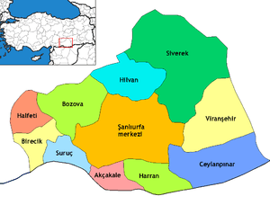
Districts
Şanlıurfa province is divided into 13 districts (capital district in bold):
Geography
Area 18,584 km² (7,173 sq. miles), the largest province of Southeast Anatolia with:
- Adıyaman to the north;
- Syria to the south;
- Mardin and Diyarbakır to the east;
- Gaziantep to the west;
Şanlıurfa includes several major components of the Southeastern Anatolia Project (in Turkish Güneydogu Anadolu Projesi (GAP)) designed to:
- exploit the hydropower potential of the Tigris and Euphrates Rivers;
- dramatically expand irrigation for agriculture; and
- develop the economy of the region.
This very large-scale, state-sponsored development project involved the damming, redirecting, hydroelectric tapping and other utilization of rivers in this broad, semi-arid region. (The rivers then flow into Syria and Iraq). The GAP project includes 22 dams, hundreds of miles of irrigation works.
Even before GAP, Şanlıurfa Province had the largest share of cultivated and cultivable land in the GAP region, due to its flatness and highly fertile, agricultural land. The Şanlıurfa and Harran Plains extend over an area of about 1,500 km² (579 sq. miles). Irrigating these plains is one of the most important components of GAP.
According to the 1990 census, Şanlıurfa Province contained 148,521 households, and the average household size was 6.74 persons. 71% of household heads described their occupation as farming. In 1992, Şanlıurfa had the highest concentration of land ownership in Turkey, with a landless rate of 48%. While 5% of the families in the province owned 65% of the land, the vast majority (70%) owned only 10%.
Şanlıurfa’s average annual growth rate between 1985 and 1990 was 4.6%, considerably higher than both the national and regional averages.
Demographics
The province has a diverse population, consisting of Kurds, Arabs, Turks and Yazidi. Kurds are estimated to make up 47% of the population.[2]
History
Politics
With Şanlıurfa once being a relatively competitive province between the ruling Justice and Development Party (AKP) and the True Path Party (DYP), it is now one of the most solid AKP provinces.
While the AKP managed to win Şanlıurfa with a comfortable 43.04% during the 2004 local elections, it has since then increased its margins of victory here. Following the diminishing popularity of smaller parties such as the DYP, Şanlıurfa heavily shifted towards the AKP, winning the November 2015 election with 64.55% of the votes. Şanlıurfa once again showed its status as an AKP stronghold in the 2017 referendum, with the Yes vote winning with a wide margin of 41.8%.
The Kurdish left-wing Peoples' Democratic Party (HDP) succeeded increasing its vote share since the 2004 election. With the Democratic People's Party (DEHAP) winning just 16.95% of the votes in the 2004 local elections, the HDP came second with 28.46% in the November 2015 general election.
The far-right Nationalist Movement Party (MHP) scored an exceptional 7.18% in the 1999 local elections. Its vote share eventually ebbed to a more usual 2.97% in the 2004 local elections. The MHP showed a significant recovery in the indecisive June 2015 election by winning 5.56% of the votes. However, the MHP went on to suffer from a nationwide loss in the upset November 2015 election, with its vote share declining to 2.75% in Şanlıurfa.
The centre-left Republican People's Party (CHP) usually maintains a modest share of slightly below 5%. Similar to the other two opposition parties, the CHP suffered a loss in Şanlıurfa, going from 4.10% in the June 2015 election to 2.70% in the November 2015 election.
The current mayor of Şanlıurfa is Nihat Çiftçi (AKP). Çiftçi survived an assassination attempt perpetuated by the outlawed Kurdistan Workers' Party (PKK) in 28 September 2015.
Places of interest
The following tombs and sacred spots are located within the province:[3]
- Prophet Ibrahim (Abraham)'s birthplace
- Prophet Ayyub (Job)'s cave and tomb
- Prophet Alyasa (Elisha)'s Tomb
- Imam Bakir's Tomb
- Shaykh Hayat al-Harrani's Tomb
- The first burial place of Said Nursi
- Rahma Hatun's Tomb
- Neolithic Temple at Göbekli Tepe
- Neolithic Settlement at Nevali Çori
Gallery
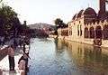
Balıklı Göl and Ridwaniya Mosque 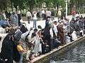
Balıklı Göl (Fish Pond) and people 
Mevlid-i Halil (Birth of Abraham) Mosque 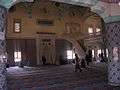
Salahaddin Mosque 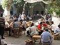
Urfa's central market 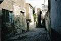
Traditional Narrow Streets 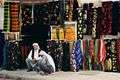
Urfa's retailers 
Harran District
See also
References
- ↑ Turkish Statistical Institute, MS Excel document – Population of province/district centers and towns/villages and population growth rate by provinces
- ↑ Watts, Nicole F. (2010). Activists in Office: Kurdish Politics and Protest in Turkey (Studies in Modernity and National Identity). Seattle: University of Washington Press. p. 167. ISBN 978-0-295-99050-7.
- ↑ TÜRBELER