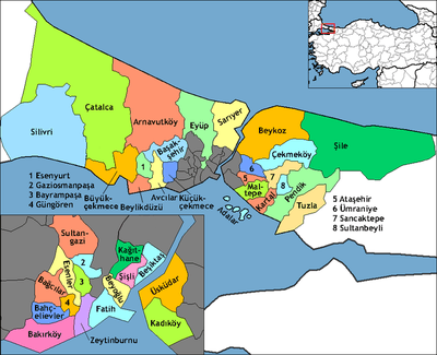
Arnavutköy (district)
| Arnavutköy | |
|---|---|
| district | |
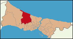 Location of Arnavutköy in Istanbul | |
 Arnavutköy Location of Arnavutköy in Istanbul | |
| Coordinates: 41°11′08″N 28°44′26″E / 41.18556°N 28.74056°ECoordinates: 41°11′08″N 28°44′26″E / 41.18556°N 28.74056°E | |
| Country | Turkey |
| City | Istanbul |
| Government | |
| • Mayor | Ahmet Haşim Baltacı (AKP) |
| • Governor | Hürrem Aksoy |
| Population (2012)[1] | |
| • Urban | 198,165 |
| • District | 206,299 |
| Time zone | UTC+2 (EET) |
| • Summer (DST) | UTC+3 (EEST) |
| Area code(s) | 0-212 |
| Website |
www |
Arnavutköy (meaning: Albanian village) is a town and rural district in Istanbul Province, Turkey. The district was newly formed in 2008 from the large rural part of Gaziosmanpaşa district and parts of other districts, including Çatalca. The mayor is Ahmet Haşim Baltacı of the AKP.
It is located on the European side of Istanbul and borders the Black Sea.
The name of a neighborhood in the district, Hadımköy, was often spelled "Hademkeui" in European sources.
References
- ↑ "Population of province/district centers and towns/villages by districts - 2012". Address Based Population Registration System (ABPRS) Database. Turkish Statistical Institute. Retrieved 2013-02-27.
- "Information on Arnavutköy district" (in Turkish). Governorship of Arnavutköy, Istanbul. 2009. Retrieved 2009-08-13.
This article is issued from
Wikipedia.
The text is licensed under Creative Commons - Attribution - Sharealike.
Additional terms may apply for the media files.