Edirne Province
| Edirne Province Edirne ili | |
|---|---|
| Province of Turkey | |
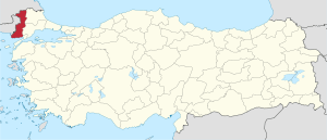 Location of Edirne Province in Turkey | |
| Country | Turkey |
| Region | West Marmara |
| Subregion | Tekirdağ |
| Government | |
| • Electoral district | Edirne |
| Area | |
| • Total | 6,279 km2 (2,424 sq mi) |
| Population (2010)[1] | |
| • Total | 401,701 |
| • Density | 64/km2 (170/sq mi) |
| Area code(s) | 0284 |
| Vehicle registration | 22 |
Edirne Province (Turkish: Edirne ili) is a province of Turkey. It is located in the East Thrace region of the country, also known as European Turkey, one of only three provinces entirely within continental Europe. Edirne Province is bordered by Tekirdağ Province and Kırklareli Province to the east, the Gallipoli peninsula of Çanakkale Province to the south-east, and international borders with Bulgaria to the north and Greece to the west.
Edirne is the capital of the province, notable for serving as the third capital of the Ottoman Empire from 1363 to 1453.
Districts
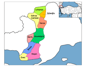
Edirne districts.
Edirne province is divided into 9 districts (capital district in bold):
See also
References
- ↑ Turkish Statistical Institute, MS Excel document – Population of province/district centers and towns/villages and population growth rate by provinces
External links
| Wikimedia Commons has media related to Edirne Province. |
| Wikisource has the text of a 1911 Encyclopædia Britannica article about Edirne Province (Ottoman Empire). |
- Edirne governor's official website (in Turkish)
- Edirne municipality's official website (in Turkish)
- Pictures of the capital of this province with its many great mosques
- Edirne Weather Forecast Information
| ||
Metropolitan municipalities are bolded. | ||
Coordinates: 41°07′12″N 26°31′14″E / 41.12000°N 26.52056°E
This article is issued from
Wikipedia.
The text is licensed under Creative Commons - Attribution - Sharealike.
Additional terms may apply for the media files.