Taipei–Keelung metropolitan area
| Taipei–Keelung metropolitan area | |
|---|---|
 | |
.svg.png) | |
| Coordinates: 25°2′N 121°38′E / 25.033°N 121.633°ECoordinates: 25°2′N 121°38′E / 25.033°N 121.633°E | |
| Country |
|
| Major Cities |
Taipei New Taipei Keelung |
| Area | |
| • Metro | 2,457.13 km2 (874.59 sq mi) |
| Population (End of September 2018) | |
| • Metro | 7,031,418 |
| • Metro density | 2,861.6/km2 (8,039.7/sq mi) |
The Taipei–Keelung metropolitan area (Chinese: 臺北基隆都會區; pinyin: Táiběi-Jīlóng Dūhùiqū) also commonly known as Greater Taipei Area (Chinese: 大臺北地區; pinyin: Dà Táiběi Dìqū) is the largest metropolitan area in Taiwan. It was recognized officially until 2010, and included Taipei, Taipei County (now New Taipei), and Keelung.
Definition
The official definition of the Taipei–Keelung metropolitan area by the government until 2010 was Taipei, Taipei County and Keelung.
| Division name | Population (30 September 2018)[1] | Area (km²) | Density (per km²) |
|---|---|---|---|
| Taipei City | 2,669,639 | 271.80 | 9,822.1 |
| New Taipei City | 3,991,411 | 2,052.57 | 1,944.6 |
| Keelung City | 370,368 | 132.76 | 2,789.8 |
| Taipei–Keelung metropolitan area | 7,031,418 | 2,457.13 | 2,861.6 |
| Taoyuan City | 2,213,379 | 1,220.95 | 1,812.8 |
| Taipei–Keelung–Taoyuan metropolitan area | 9,244,797 | 3,678.08 | 2,513.5 |
Some international reports consider Taipei–Keelung–Taoyuan (臺北基隆桃園都會區; Táiběi–Jīlóng–Táoyuán Dūhùiqū) as a real complete metropolitan area.[1][2][3]
Geography
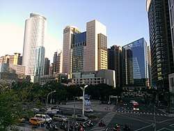
Due to the geographical characteristics of the area, the Taipei–Keelung metropolitan area roughly corresponds to areas located within the Taipei Basin. Taipei City serves as the core of the metropolitan area where the government of Taiwan and major commercial districts are located.
Geographical Subdivision
The metropolitan area contains Taipei City, Keelung City, and New Taipei City (surrounding the two previous cities). The geographical subdivision listed as followed.
|
Northwest
in New Taipei City: |
North
in New Taipei City: in Taipei City: |
East
in Keelung City:
in Taipei City: in New Taipei City: |
|
Center
in Taipei City: | ||
|
Southwest
in New Taipei City: | ||
|
South
in New Taipei City: |
GDP
2014 Taipei–Keelung metropolitan area's GDP per capita(PPP) was US$46,102.[4]
Transportation
Rail
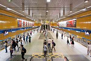
The Taipei–Keelung metropolitan area is served by routes of the Taiwan Railway Administration (Western Line) and Taiwan High Speed Rail which connect the area with all parts of the island. For rapid transit, Taipei and New Taipei are served by the Taipei Metro with daily trips of over 2 million passengers.
Air
The area is served by Taiwan Taoyuan International Airport for international flights while Songshan Airport is primarily for domestic flights, international flights to Tokyo and Seoul; and also cross-strait flights.
Bus
An extensive bus system serves the metropolitan area.
See also
- Administrative divisions of the Republic of China
- Geography of Taiwan
- List of metropolitan areas in Asia by population
- List of Taiwanese counties and cities by area
- List of Taiwanese counties and cities by population
- List of Taiwanese counties and cities by population density
- Political divisions of Taiwan (1895-1945)
References
- 1 2 鄉鎮市區人口及按都會區統計. Taiwan Ministry of Interior. 2013.
- ↑ World: metropolitan areas Archived 2007-09-30 at the Wayback Machine. World Gazetteer, 2010
- ↑ Taipei: largest cities and towns and statistics of their population Archived 2011-09-02 at the Wayback Machine. World Gazetteer, 2010
- ↑ https://www.brookings.edu/research/global-metro-monitor/