Artvin Province
| Artvin Province Artvin ili | |
|---|---|
| Province of Turkey | |
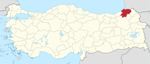 Location of Artvin Province in Turkey | |
| Country | Turkey |
| Region | East Black Sea |
| Subregion | Trabzon |
| Government | |
| • Electoral district | Artvin |
| Area | |
| • Total | 7,436 km2 (2,871 sq mi) |
| Population (2010)[1] | |
| • Total | 168,068 |
| • Density | 23/km2 (59/sq mi) |
| Area code(s) | 0466 |
| Vehicle registration | 08 |
Artvin Province (Turkish: Artvin ili; Georgian: ართვინის პროვინცია, Artvinis p’rovincia) is a province in Turkey, on the Black Sea coast in the northeastern corner of the country, on the border with Georgia.
The provincial capital is the city of Artvin.
Geography
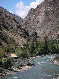
Artvin is an attractive area of steep valleys carved by the Çoruh River system, surrounded by high mountains of Kaçkar, Karçal and Yalnızçam (up to 3900 m) and forest with much national parkland including the Karagöl-Sahara, which contains the Şavşat and Borçka lakes. The weather in Artvin is very wet and mild at the coast, and as a result is heavily forested. This greenery runs from the top all the way down to the Black Sea coast. The rain turns to snow at higher altitudes, and the peaks are very cold in winter.[2]
The forests are home to brown bears and wolves. The Çoruh is now being dammed in 11 places for hydro-electric power, including the 249 m Deriner Dam and others at Borçka and Muratlı.
In addition to the vast majority ethnic Turks, the province is home to communities of Laz people and Hemshin peoples. Autochthonous Muslim Georgians form the majority in parts of Artvin Province east of the Çoruh River. Immigrant groups of Georgian origins, found scattered in Turkey are known as Chveneburi.[3] In particular, there is a prominent community of Chveneburi Georgians many of them descendants of Muslim families from Georgia who migrated during the struggles between the Ottoman Turks and Russia during the 19th century. With such diverse peoples, Artvin has a rich variety of folk song and dance (see Arifana and Kochari for examples of folk culture).[4]
Local industries include bee-keeping especially in Macahel region.[5]
Artvin is traversed by the northeasterly line of equal latitude and longitude.
Places of interest
- The city of Artvin has an ancient castle and a number of Ottoman period houses, mosques, and fountains.
- Every June, there is a "bull-wrestling" festival in the high plateau of Kafkasör
- The Parekhi monastery, a Georgian monastery
Popular places for walking and outdoor expeditions.
- The Kaçkar Mountains are among the most-popular venues for trekking holidays in Turkey.
- Macahel Valley on the Georgian border, is another popular location for walking holidays.
- Papart forest in Şavşat
- Genciyan Hill in Şavşat, overlooks the border and the Binboğa lakes.
- The lakes of Şavşat and Borçka and the crater lake of Kuyruklu.
- The Çoruh River is excellent for rafting and championships have been held here
- There are a number of Georgian churches in the valleys of Yusufeli.
- Bilbilan Yaylası - a typical Turkish high meadow.
- Savangin pre-historical cave with an inscription written in an unknown or unsolved alphabet
Notable residents
- Zülfü Livaneli, singer and politician, born into a family from Yusufeli
- Kazım Koyuncu, folk rock singer, guitarist and composer, born in Artvin's Black Sea town of Hopa
- Şükriye Tutkun, folk singer
- Mircan Kaia, singer, composer and engineer, born into a family from Borcka
Districts
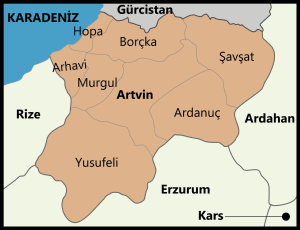
Central district also has the same name just like most provinces in Turkey.
In 1924, the Liva Sanjak was abolished and the Artvin Vilayet was created. Artvin Vilayet was combined with Rize to form Çoruh Vilayet with the capital at Rize. Later it was separated into Artvin Province with the districts of Ardanuç, Arhavi, Artvin, Borçka, Hopa, Murgul, Şavşat and Yusufeli.[6]
Artvin province is divided into 8 districts (capital district in bold):
Sister cities
See also
References
- ↑ Turkish Statistical Institute, MS Excel document – Population of province/district centers and towns/villages and population growth rate by provinces
- ↑ Artvin geography (tr)
- ↑ Peoples of the Caucasus in Turkey
- ↑ Artvin Archived November 5, 2011, at the Wayback Machine.
- ↑ Artvin Macahel Archived May 11, 2012, at the Wayback Machine.
- ↑ Artvin Archived November 5, 2011, at the Wayback Machine.
External links
| Wikimedia Commons has media related to Artvin Province. |
- (in Turkish) the provincial governorate
- (in English) Artvin Weather Forecast Information
- (in English)Çoruh River Valley and future of artvin city
- (in English) Armenian History and Presence in Artvin
- (in Turkish) Artvin has a Wikipedia all of its own including...
- photos of Artvin
- HQ pictures of Artvin
- more photos
- World Wildlife Fund report on the area
- (in Turkish) photos and villages of Artvin

| ||
Metropolitan municipalities are bolded. | ||