İzmir Province
| Izmir Province Izmir ili | |
|---|---|
| Province of Turkey | |
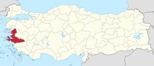 Location of Izmir Province in Turkey | |
| Country | Turkey |
| Region | Aegean |
| Subregion | Izmir |
| Provincial seat | Konak (de-facto; Turkish metropolises have no capital districts) |
| Government | |
| • Electoral district | Izmir |
| • Governor | Mustafa Toprak |
| Area | |
| • Total | 11,973 km2 (4,623 sq mi) |
| Population (2017)[1] | |
| • Total | 4,279,677 |
| • Density | 360/km2 (930/sq mi) |
| Area code(s) | 0232 |
| Vehicle registration | 35 |
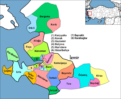
İzmir Province (Turkish: Izmir ili) is a province and metropolitan municipality of Turkey in western Anatolia, situated along the Aegean coast. Its capital is the city of İzmir, which is in itself composed of the province's central 10 districts out of 30 in total. To the west, it is surrounded by the Aegean Sea, and it encloses the Gulf of Izmir. Its area is 11,973 square kilometres (4,623 square miles), with a population of 4,279,677 in 2017.[2] The population was 3,370,866 in 2000. Neighboring provinces are Balıkesir to the north, Manisa to the east, and Aydın to the south. The traffic code of the province is 35.
Major rivers of the province include the Küçük Menderes river, Koca Çay (with Güzelhisar dam), and Bakırçay.
Districts
History
The area was first settled by local Anatolians. Millennia later, Ionians in about the 11th century BC established the League of Ionia. It was later conquered by the Persians and retaken by the Greeks before being subsumed into the Roman Empire. After the split of the Roman Empire, the area became part of what is now called the Byzantine Empire until it was conquered by the Ottoman Turks in the 14th century. Following the First World War, the province was ceded to Greece, but was retaken by the forces of Mustafa Kemal Atatürk in the Turkish War of Independence. As a result of the Treaty of Lausanne (1923), all Greek Orthodox inhabitants of the province had to leave, and İzmir Province was incorporated into the modern republic of Turkey.
See also
References
- ↑ Turkish Statistical Institute, MS Excel document – Population of province/district centers and towns/villages and population growth rate by provinces
- ↑ "İzmir Nüfusu". www.nufusu.com (in Turkish). Retrieved 2018-04-15.
External links
| Wikimedia Commons has media related to Izmir Province. |
- (in Turkish) İzmir governor's official website
- İzmir metropolitan municipality's official website
- (in Turkish) Directorate of Culture and Tourism in İzmir
- (in Turkish) Local administrations in İzmir
- İzmir weather forecast information
Coordinates: 38°29′04″N 27°08′26″E / 38.48444°N 27.14056°E
| ||
Metropolitan municipalities are bolded. | ||