Pamukkale
| UNESCO World Heritage site | |
|---|---|
 | |
| Official name | Hierapolis-Pamukkale |
| Location | Denizli, Turkey |
| Criteria | Cultural and Natural: (iii)(iv)(vii) |
| Reference | 485 |
| Inscription | 1988 (12th Session) |
| Area | 1,077 ha (4.16 sq mi) |
| Website |
www |
| Coordinates | 37°55′26″N 29°07′24″E / 37.92389°N 29.12333°ECoordinates: 37°55′26″N 29°07′24″E / 37.92389°N 29.12333°E |
 Location of Pamukkale in Turkey | |
Pamukkale, meaning "cotton castle" in Turkish, is a natural site in Denizli in southwestern Turkey. The area is famous for a carbonate mineral left by the flowing water.[1] It is located in Turkey's Inner Aegean region, in the River Menderes valley, which has a temperate climate for most of the year.
The ancient Greco-Roman city of Hierapolis was built on top of the white "castle" which is in total about 2,700 metres (8,860 ft) long, 600 m (1,970 ft) wide and 160 m (525 ft) high. It can be seen from the hills on the opposite side of the valley in the town of Denizli, 20 km away.
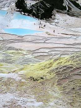
Known as Pamukkale (Cotton Castle) or ancient Hierapolis (Holy City), this area has been drawing the weary to its thermal springs since the time of Classical antiquity.[1] The Turkish name refers to the surface of the shimmering, snow-white limestone, shaped over millennia by calcium-rich springs. Dripping slowly down the vast mountainside, mineral-rich waters foam and collect in terraces, spilling over cascades of stalactites into milky pools below. Legend has it that the formations are solidified cotton (the area’s principal crop) that giants left out to dry.
Tourism is and has been a major industry in the area for thousands of years, due to the attraction of the thermal pools.[1] As recently as the mid-20th century, hotels were built over the ruins of Hierapolis, causing considerable damage. An approach road was built from the valley over the terraces, and motor bikes were allowed to go up and down the slopes. When the area was declared a World Heritage Site, the hotels were demolished and the road removed and replaced with artificial pools.
Overshadowed by natural wonder, Pamukkale’s well-preserved Roman ruins and museum have been remarkably underestimated and unadvertised; tourist brochures over the past 20 years have mainly featured photos of people bathing in the calcium pools. Aside from a small footpath running up the mountain face, the terraces are all currently off-limits, having suffered erosion and water pollution at the feet of tourists.
Geology
Pamukkale's terraces are made of travertine, a sedimentary rock deposited by water from the hot springs.[1]
In this area, there are 17 hot water springs in which the temperature ranges from 35 °C (95 °F) to 100 °C (212 °F). The water that emerges from the spring is transported 320 metres (1,050 ft) to the head of the travertine terraces and deposits calcium carbonate on a section 60 to 70 metres (200 to 230 ft) long covering an expanse of 24 metres (79 ft) to 30 metres (98 ft). When the water, supersaturated with calcium carbonate, reaches the surface, carbon dioxide de-gasses from it, and calcium carbonate is deposited. Calcium carbonate is deposited by the water as a soft gel which eventually crystallizes into travertine.

Archeology
Museum
In this museum, alongside historical artifacts from Hierapolis, there are also artifacts from Laodiceia, Colossae, Tripolis, Attuda and other towns of the Lycos (Çürüksu) valley. In addition to these, the museum has a large section devoted to artifacts found at Beycesultan Hüyük that includes some of the most beautiful examples of Bronze Age craft.
Artifacts from the Caria, Pisidia and Lydia regions are also on display in this museum. The museum’s exhibition space consists of three closed areas of the Hierapolis Bath and the open areas in the eastern side which are known to have been used as the library and gymnasium. The artifacts in open exhibition space are mostly marble and stone. Hierapolis is broken down into ruins.
Tourist attraction
Pamukkale (video)
Short video showing the Pamukkale natural site | |
Problems playing this file? See media help. | |
Pamukkale is a tourist attraction. It is recognized as a World Heritage Site together with Hierapolis. Hierapolis-Pamukkale was made a World Heritage Site in 1988.[2]
The underground volcanic activity which causes the hot springs also forced carbon dioxide into a cave, which was called the Plutonium, which here means "place of the god Pluto". This cave was used for religious purposes by priests of Cybele, who found ways to appear immune to the suffocating gas.
Protecting the thermal waters
The hotels built in the 1960s were demolished as they were draining the thermal waters into their swimming pools and caused damage to the terraces. The water supply to the hotels is restricted in an effort to preserve the overall site and to allow deposits to regenerate.[4]
Access to the terraces is not allowed and visitors are asked to follow the pathway.[4]
Gallery
 The pools of Pamukkale
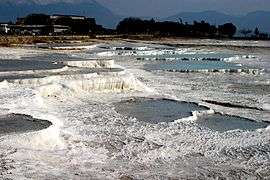 Hot springs of Pamukkale
 The reflection of the limestone in a hot spring at Pamukkale
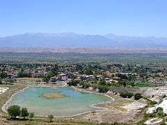 The town of Pamukkale, at the foot of the hot springs
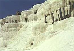 A hanging limestone wall at Pamukkale
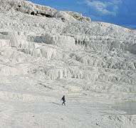 Limestone wall
 The pools of Pamukkale
 The pools of Pamukkale
 Beautiful Pamukkale travertines during winter
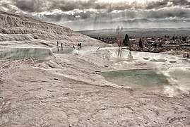
 Travertine hot springs at Pamukkale
 Travertine hot springs at Pamukkale
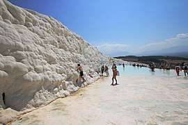
 Travertine terraces of Pamukkale at springtime
Sister cities
The village of Pamukkale has two sister cities:
Similar places
These locations are also well-known for their travertine formations:
- Egerszalók in Hungary
- Badab-e Surt in Iran
- Mammoth Hot Springs in the USA
- Pink and White Terraces in New Zealand[5][6]
- Hierve el Agua in Mexico
- The White Whale in Italy - Bagni San Filippo (Siena)
- Baishuitai in China
- Garmchashma in Tajikistan[7]
- Tatev in Armenia[8]
- Terme di Saturnia in Italy
- Huanglong Scenic and Historic Interest Area, A similar UNESCO world heritage travertine cascade in China.
- Dolok Tinggi Raja in Simalungun Sumatra Indonesia [9]
Notes
- 1 2 3 4 Scheffel, Richard L.; Wernet, Susan J., eds. (1980). Natural Wonders of the World. United States of America: Reader's Digest Association, Inc. p. 286. ISBN 0-89577-087-3.
- ↑ "Hierapolis-Pamukkale World Heritage Site". UNESCO World Heritage Centre. Retrieved 2007-06-23.
- ↑ "Pamukkale Turkey Hotel And Hostel Redesigned". PRLog. 2009-01-10. Retrieved 2009-09-02.
- 1 2 Pamukkale Travetines Denizli
- ↑ Bunn, Rex; Nolden, Sascha (2017-06-07). "Forensic cartography with Hochstetter's 1859 Pink and White Terraces survey: Te Otukapuarangi and Te Tarata". Journal of the Royal Society of New Zealand. 0 (0): 1–18. doi:10.1080/03036758.2017.1329748. ISSN 0303-6758.
- ↑ Bunn and Nolden, Rex and Sascha (December 2016). "Te Tarata and Te Otukapuarangi: Reverse engineering Hochstetter's Lake Rotomahana Survey to map the Pink and White Terrace locations". Journal of New Zealand Studies. NS23: 37–53.
- ↑ Garmchashma in Tajikistan
- ↑ Satani Kamurj
- ↑ https://id.m.wikipedia.org/wiki/Dolok_Tinggi_Raja
External links
| Wikimedia Commons has media related to Pamukkale. |
- Pamukkale official site

- Pamukkale - spherical panorama 360 degree
- UNESCO World Heritage site datasheet
- The Marble Stairs of Heaven on Earth: Pamukkale
- Pamukkale Travel Guide
- Photos and first hand account of visit including Hierapolis and Cleopatra's pool
- Visiting the Cotton Castle – Geobeats.com on Youtube
- Video from Pamukkale (4k, UltraHD)