Safranbolu
| Safranbolu | |
|---|---|
| District | |
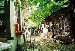 A street at the historical market of shoemakers in Safranbolu | |
 Location of Safranbolu within Turkey. | |
 Safranbolu Location of Safranbolu | |
| Coordinates: 41°15′N 32°41′E / 41.250°N 32.683°E | |
| Country |
|
| Region | Black Sea |
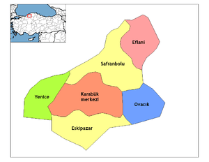
| Province | Karabük |
| Government | |
| • Mayor | Necdet Aksoy (AKP) |
| Area[1] | |
| • District | 999.99 km2 (386.10 sq mi) |
| Elevation | 485 m (1,591 ft) |
| Population (2012)[2] | |
| • Urban | 43,060 |
| • District | 55,170 |
| • District density | 55/km2 (140/sq mi) |
| Time zone | UTC+2 (EET) |
| • Summer (DST) | UTC+3 (EEST) |
| Postal code | 78xxx |
| Area code(s) | 370 |
| Licence plate | 78 |
| Climate | Cfa |
| Website | www.safranbolu.bel.tr |
| UNESCO World Heritage site | |
| Criteria | Cultural: ii, iv, v |
| Reference | 614 |
| Inscription | 1994 (18th Session) |
| Area | 193 ha |
Safranbolu (Greek: Σαφράμπολις, Saframpolis) is a town and district of Karabük Province in the Black Sea region of Turkey. It is about 9 km north of the city of Karabük, 200 kilometres (120 mi) north of Ankara and about 100 km south of the Black Sea coast. The town's historic names in Greek were Theodoroupolis (Θεοδωρούπολις, i.e. city of Theodorus or female Theodora) and later Saframpolis (Σαφράμπολις). Its former names in Turkish were Zalifre and Taraklıborlu. It was part of Kastamonu Province until 1923 and Zonguldak Province between 1923 and 1995.
According to the 2000 census, the population of the district was 47,257, of which 31,697 lived in the town of Safranbolu.[3] The district covers an area of 1,000 km2 (386 sq mi),[4] and the town lies at an elevation of 485 m (1,591 ft).
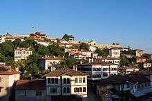
The Old Town preserves many historic buildings, with 1008 registered historical artifacts. These are: 1 private museum, 25 mosques, 5 tombs, 8 historical fountains, 5 Turkish baths, 3 caravanserais, 1 historical clock tower, 1 sundial and hundreds of houses and mansions. Also, there are mounds of ancient settlements, rock tombs and historical bridges. The Old Town is situated in a deep ravine in a fairly dry area in the rain shadow of the mountains. The New Town can be found on the plateau about two kilometers west of the Old Town.
The name of the town derives from "saffron" and the Greek word polis (πόλις) meaning "city",[5][6] since Safranbolu was a trading place and a center for growing saffron.[5][6] Today, saffron is still grown at the village of Davutobası to the east of Safranbolu, with a road distance of 22 kilometres.[5][6]
Safranbolu was added to the list of UNESCO World Heritage sites in 1994 due to its well-preserved Ottoman era houses and architecture.[7]
Gallery
 General view
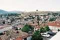 General view
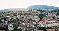 General view
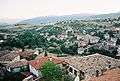 General view
 General view
 Roman arches on the brook between the buildings and streets in the historical centre
 Street in the historical centre
 Brook under the buildings and streets in the historical centre
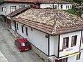 Safranbolu Pansiyon
 Traditional houses
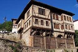 Traditional houses
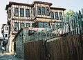 Traditional houses
 Traditional houses
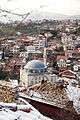 Safranbolu and the İzzet Mehmet Pasha Mosque

Sister cities
Notable natives
- Karabaşzade Hüseyin Efendi (Cinci Hoca) - Mentor of Ottoman Sultan İbrahim in the 17th century
- Safranbolulu Izzet Mehmet Pasha, 18th century Ottoman Grand Vizier, in office 1794–1798
- Türker İnanoğlu (b. 1936), film producer
- Ali Gümüş (1940–2015), President of the Wrestling Commission of the International Sports Press Association (Association Internationale de la Presse Sportive, AIPS), journalist and author
Notes
- ↑ "Area of regions (including lakes), km²". Regional Statistics Database. Turkish Statistical Institute. 2002. Retrieved 2013-03-05.
- ↑ "Population of province/district centers and towns/villages by districts - 2012". Address Based Population Registration System (ABPRS) Database. Turkish Statistical Institute. Retrieved 2013-02-27.
- ↑ Turkish Statistical Institute. "Census 2000, Key statistics for urban areas of Turkey" (in Turkish). Archived from the original (XLS) on 2007-07-22. Retrieved 2008-11-22.
- ↑ Statoids. "Statistical information on districts of Turkey". Archived from the original on 2010-05-26. Retrieved 2008-11-22.
- 1 2 3 "Safranbolu". World Heritage Site. Retrieved 3 February 2017.
- 1 2 3 "Saffron Harvest in the Land of the Golden Plant". Cornucopia. Retrieved 3 February 2017.
- ↑ "City of Safranbolu". UNESCO World Heritage Convention. Retrieved 3 February 2017.
- ↑ Elabuga and Safranbolu become sister cities Archived May 3, 2014, at the Wayback Machine.
See also
References
- Falling Rain Genomics, Inc. "Geographical information on Safranbolu, Turkey". Archived from the original on 2012-10-26. Retrieved 2008-11-22.
External links
| Wikimedia Commons has media related to Safranbolu. |

- Governor's official web site
- UNESCO World Heritage - Safranbolu
- Safranbolu: A Town of Traditional Houses
Coordinates: 41°14′57.80″N 32°40′59.52″E / 41.2493889°N 32.6832000°E