Bingöl Province
| Bingöl Province Bingöl ili | |
|---|---|
| Province of Turkey | |
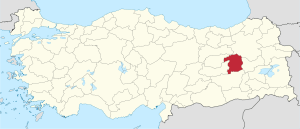 Location of Bingöl Province in Turkey | |
| Country | Turkey |
| Region | Central East Anatolia |
| Subregion | Malatya |
| Government | |
| • Electoral district | Bingöl |
| Area | |
| • Total | 8,125 km2 (3,137 sq mi) |
| Population (2009)[1] | |
| • Total | 269,560 |
| • Density | 33/km2 (86/sq mi) |
| Area code(s) | 0426 |
| Vehicle registration | 12 |
Bingöl Province (Turkish: Bingöl ili; Kurdish: Parêzgeha Bîngolê, Zazaki: Çewlîg, Northern Kurdish: Çewlîg; Armenian: Ճապաղջուր Chapaghjur) is a province of Turkey in Eastern Anatolia. The province was created in 1946 out of parts of Elazığ and Erzincan. The new province was known as Çapakçur Province until 1950. Its neighbouring provinces are Tunceli, Erzurum, Muş, Diyarbakır, Erzincan and Elazığ. The province covers an area of 8,125 km² and has a population of 255,170. The main spoken languages are Turkish and Zazaki/Kurdish. The capital is Bingöl. The majority of the province's population is Kurdish.[2]
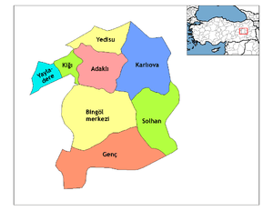
Districts
Bingöl province is divided into 8 districts (capital district in bold):
References
- ↑ Turkish Statistical Institute, MS Excel document – Population of province/district centers and towns/villages and population growth rate by provinces
- ↑ Watts, Nicole F. (2010). Activists in Office: Kurdish Politics and Protest in Turkey (Studies in Modernity and National Identity). Seattle: University of Washington Press. p. 167. ISBN 978-0-295-99050-7.
External links
| Wikimedia Commons has media related to Bingöl Province. |
- (in Turkish) Bingöl governor's official website
- (in Turkish) Bingöl municipality's official website
- Bingöl weather forecast information
- (in Turkish) Bingöl and Solhan local news website
| ||
Metropolitan municipalities are bolded. | ||
Coordinates: 39°02′28″N 40°40′33″E / 39.04111°N 40.67583°E
| Authority control |
|---|
This article is issued from
Wikipedia.
The text is licensed under Creative Commons - Attribution - Sharealike.
Additional terms may apply for the media files.