Diyarbakır Province
| Diyarbakır Province Diyarbakır ili | |
|---|---|
| Province of Turkey | |
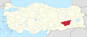 Location of Diyarbakır Province in Turkey | |
| Country | Turkey |
| Region | Southeast Anatolia |
| Subregion | Şanlıurfa |
| Government | |
| • Electoral district | Diyarbakır |
| • Governor | Hasan Basri GÜZELOĞLU |
| Area | |
| • Total | 15,355 km2 (5,929 sq mi) |
| Population (2010)[1] | |
| • Total | 1,673,119 |
| • Density | 110/km2 (280/sq mi) |
| Area code(s) | 0412 |
| Vehicle registration | 21 |
Diyarbakır Province (Turkish: Diyarbakır ili, Kurdish: Parêzgeha Amed) is a province in southeastern Turkey . The province covers an area of 15,355 km² and its population is 1,528,958. The provincial capital is the city of Diyarbakır.
It has been home to many civilisations and the surrounding area including itself is home to many Mesolithic era stone carvings and artifacts. The province has been ruled by the Akkadins, Hurrians, Mittani, Medes, Hittites, Armenians, Neo-Babylonians, Achaemenids, Greeks, Romans, Parthia, Byzantium, Sassanids, Arabs, Seljuk Empire, Mongol Empire, Safavid dynasty, Marwanids, and Ayyubids.
The majority of the province's population today is Kurdish.[2]
| Assyrian and Armenian population in Diyarbakır Province in 1915-1916[3] | |||||
| Sect | Before World War I | Disappeared (killed) | After World War I | ||
|---|---|---|---|---|---|
| Armenians | Gregorians (Apostolic) | 60,000 | 58,000 (97%) | 2,000 | |
| Armenian Catholics | 12,500 | 11,500 (92%) | 1,000 | ||
| Assyrians | Chaldean Catholics | 11,120 | 10,010 (90%) | 1,110 | |
| Syriac Catholic | 5,600 | 3,450 (62%) | 2,150 | ||
| Syriac Orthodox | 84,725 | 60,725 (72%) | 24,000 | ||
| Protestants | 725 | 500 (69%) | 2,150 | ||
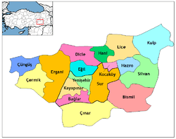
Districts
Diyarbakır province is divided into 14 districts (capital district in bold):
References
- ↑ Turkish Statistical Institute, MS Excel document – Population of province/district centers and towns/villages and population growth rate by provinces
- ↑ Watts, Nicole F. (2010). Activists in Office: Kurdish Politics and Protest in Turkey (Studies in Modernity and National Identity). Seattle: University of Washington Press. p. 167. ISBN 978-0-295-99050-7.
- ↑ Gaunt, David. Massacres, Resistance, Protectors: Muslim-Christian Relations in Eastern Anatolia during World War I. Piscataway, N.J.: Gorgias Press, 2006, p. 433.
External links
- (in English) Pictures of the capital of this province
- (in English) Diyarbakir Weather Forecast Information
- (in English) Historical Armenian presence in Diyarbakir Province
- Tourism information is available in English at the Southeastern Anatolian Promotion Project site.
- (in English) Diyarbakir Live News
| ||
Metropolitan municipalities are bolded. | ||
Coordinates: 38°08′32″N 40°16′16″E / 38.14222°N 40.27111°E