Orchid Island (Florida)
Orchid Island aka "North Hutchinson Island" is the northern portion of North Hutchinson Island, an Atlantic coastal barrier island in Indian River County, Florida, United States.[1] North Hutchinson island is separated from the mainland on the west by the Indian River Lagoon. North Hutchinson Island is known for beautiful beaches, restaurants, shops, wildlife preserves and parks. See the North Hutchinson Island wiki for additional information.
Main roads
The principal north-south road on the island is State Road A1A which runs the entire length of North Hutchinson Island. It is called South A-1-A from Beachland Boulevard south and North A-1-A north of Beachland Boulevard.
South Beach
The area from the southern county line to Vero Beach is known as South Beach. It is an unincorporated area, and for population purposes it is recorded as a census-designated place.
Sites of interest
County-maintained Round Island Park abuts the county line on the south and runs from the ocean to the river.[2]
See the North Hutchinson wiki for more sites of interest.
Vero Beach
The city of Vero Beach lies on both sides of the Indian River, with its main business and residential areas on the mainland. Two of the island's bridges from the mainland lie within the city limits. The Riomar Country Club built in the 1920s set the tone for residential development on the island. The city adopted stringent planning and zoning regulation to support the area's natural beauty.[3]
Sites of interest
- Riverside Park at the foot of the New Merrill Barber Bridge is the location of the Vero Beach Art Museum,[4] the Riverside Theatre and the Riverside Children's Theatre.[5]
- Driftwood Inn and Restaurant, listed on the National Register of Historic Places, is at Sexton Park on the ocean.
See the North Hutchinson wiki for additional sites of interest.
Indian River Shores
The town of Indian River Shores occupies Orchid Island north of Vero Beach and south of Wabasso Beach.[6]
Community of John's Island
John's Island is a community of 1,650 acres (6.7 km2) within the town limits.[7]
Wabasso Beach
Wabasso Beach is an unincorporated census-designated place lying north of the town of Indian River Shores and south of the town of Orchid. It is centered around the intersection of North A-1-A and Wabasso Road, which comes across the Wabasso Bridge from the mainland. County-maintained Wabasso Beach Park is located just east of this intersection.[2]
Sites of interest
- Disney's Vero Beach Resort is located in Wabasso Beach.[8]
Orchid
The town of Orchid lies north of Wabasso Beach and is mainly to the north of Wabasso Road (SR 510). It consists primarily of the Orchid Island Golf and Beach Club, although it was originally incorporated by the grove owners located in the area and covered somewhat different lands. The town does have some territory on the Atlantic.[9]
Windsor Community
North of Orchid is the gated community of Windsor, recorded as a census-designated place.
Sites of interest
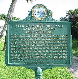
- McLarty Treasure Museum at Sebastian Inlet State Park[10]
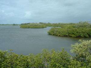
- Pelican Island National Wildlife Refuge is located in the Indian River Lagoon north of Windsor.[11]
- Sebastian Fishing Museum
- Sebastian Inlet State Park is located at the north end of Orchid Island and extends across the Sebastian Inlet into Brevard County.[12]
Archie Carr National Wildlife Refuge
The Archie Carr National Wildlife Refuge, established for the protection of sea turtles, extends from Wabasso Beach on Orchid Island north along the coast to Melbourne Beach.
References
- ↑ http://www.florida-living.us/articles/orchid_island.php
- 1 2 WWW.IRCGOV.COM - Indian River County Board of County Commissioners - Public Works - Parks Maintenance Division - All Parks
- ↑ Vero Beach History, Summary
- ↑ The Vero Beach Museum of Art
- ↑ Riverside Theatre - Home
- ↑ "Archived copy". Archived from the original on 2007-09-10. Retrieved 2007-09-06.
- ↑ John's Island Real Estate Company: Community
- ↑ http://www.luxuryhomesofvero.com/Orchid-Island.php
- ↑ Town of Orchid: About Our Town
- ↑ Treasure coin McLarty Treasure Museum Located on a National Historical Landmark; Site of the 1715 Spanish Plate Fleet McLarty Treasure Museum Archived 2007-08-25 at the Wayback Machine.
- ↑ Pelican Island National Wildlife Refuge
- ↑ Main Page - Sebastian Inlet State Park » Florida State Parks
External links
| Wikimedia Commons has media related to Orchid Island (Florida). |
- Town of Indian River Shores
- Town of Orchid
- Pelican Island National Wildlife Refuge
- Sebastian Inlet State Park
- City of Vero Beach
- Riverside Theatre
Municipalities and communities of Indian River County, Florida, United States | ||
|---|---|---|
| Cities | 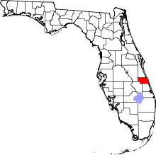 | |
| Towns | ||
| CDPs | ||
| Unincorporated communities | ||

Coordinates: 27°51′31″N 80°26′59″W / 27.85861°N 80.44972°W