Siwan, Bihar
| Siwan सिवान | |
|---|---|
| City | |
 Siwan Location in Bihar, India | |
| Coordinates: 26°13′N 84°22′E / 26.22°N 84.36°ECoordinates: 26°13′N 84°22′E / 26.22°N 84.36°E | |
| Country |
|
| State | Bihar |
| District | Siwan |
| Subdivision | Siwan Subdivision |
| Block | Siwan Block |
| Established | 1924[1] |
| Government | |
| • Type | Council–manager |
| • Body | Siwan Municipal Council |
| Area[1] | |
| • Total | 13.05 km2 (5.04 sq mi) |
| Area rank | 53rd |
| Elevation | 72 m (236 ft) |
| Population (2011)[2] | |
| • Total | 135,066 |
| • Rank | 18th |
| • Density | 10,000/km2 (27,000/sq mi) |
| Languages | |
| • Official | Hindi |
| Time zone | UTC+5:30 (IST) |
| Pin Code | 841226-841227 |
| ISO 3166 code | IN-BR |
| Vehicle registration | BR-29 |
| Climate | Cwa |
| Lok Sabha constituency | Siwan |
| Vidhan Sabha constituency | Siwan |
| Website | https://www.siwanonline.com/ |
Siwan is a city (Nagar Parishad; Hindi: सिवान नगर परिषद) and the district headquarters of the Siwan district in the Indian state of Bihar. It is also block headquarter of Siwan block. It is one out of three municipalities located in Siwan district which is Nagar Parishad, the two other municipalities are Nagar Panchayat. It is located close to Uttar Pradesh. The town is known for its great past especially for First President of Indian Republic who belonged to Ziradei.[3]
Siwan Nagar Parishad is a part of Siwan Block, which consists 1 Nagar Parishad and many villages. Siwan Block is one of 13 blocks situated in Siwan Subdivision of Siwan District. [2]
The total area of the city is 13.05 square kilometres (5.04 sq mi) and the total population of city is 135066 as of 2011 Census of India. The city is divided into 38 wards.[2]
History
Siwan got its name probably from Shiva man (शिव मान), who was a ruler in this area until Babar's arrival.[4]
The Siwan Municipal Council (SMC) was established in 1924. [1]
Siwan district carved out from Saran district in 1972 and the Siwan city became the headquarters. [5]
Geography and climate
Siwan city is located at coordinates 26°13′N 84°22′E / 26.22°N 84.36°E Latitude and longitude. It has an average elevation of 72 metres (236 ft).[6] Daha River, which is a small river, which floods in rainy season pass through the west of the town. The river dry up during summer. Daha river is the most polluted river of Siwan district.
The weather of Siwan is mild and generally warm and temperate. This climate is considered to be Cwa according to the Köppen-Geiger climate classification. [7]
| Month | Jan | Feb | Mar | Apr | May | Jun | Jul | Aug | Sep | Oct | Nov | Dec | Year |
|---|---|---|---|---|---|---|---|---|---|---|---|---|---|
| Average high °C (°F) | 23.1 (73.6) |
26.1 (79) |
32.4 (90.3) |
36.2 (97.2) |
38.6 (101.5) |
36.2 (97.2) |
32.8 (91) |
32.3 (90.1) |
32. (90) |
31.8 (89.2) |
28.7 (83.7) |
24.7 (76.5) |
31.2 (88.3) |
| Daily mean °C (°F) | 16.4 (61.5) |
18.9 (66) |
24.5 (76.1) |
28.9 (84) |
32 (90) |
31.4 (88.5) |
29.4 (84.9) |
29.2 (84.6) |
28.7 (83.7) |
26.7 (80.1) |
21.6 (70.9) |
17.6 (63.7) |
25.4 (77.8) |
| Average low °C (°F) | 9.8 (49.6) |
11.8 (53.2) |
16.7 (62.1) |
21.7 (71.1) |
25.5 (77.9) |
26.6 (79.9) |
26 (79) |
26.2 (79.2) |
25.5 (77.9) |
21.7 (71.1) |
14.5 (58.1) |
10.5 (50.9) |
19.7 (67.5) |
| Average precipitation mm (inches) | 21 (0.83) |
7 (0.28) |
11 (0.43) |
7 (0.28) |
25 (0.98) |
164 (6.46) |
257 (10.12) |
316 (12.44) |
192 (7.56) |
54 (2.13) |
6 (0.24) |
2 (0.08) |
1,062 (41.83) |
| Source: Climate-data.org[7] | |||||||||||||
Demographics
As of 2011 India census,[8] Siwan city had a population of 1,35,066 of which Males 70,756 and females 64,310. Siwan has a literacy rate of 79.61%, higher than the state average of 63.8%: male literacy is 85.17%.
Education
The total population of siwan city is 135,066, in which about 80% people are educated. [9]
There are a number of middle schools, high schools and colleges available in Siwan.
Colleges
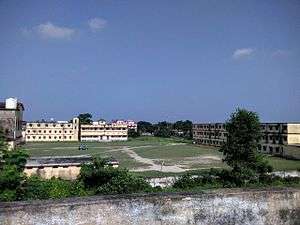
There are a number of colleges in Siwan [10]
- Rajendra Kishori B Ed College Of Education
- Z A Islamia College
- Dayanad Ayurved College and Hospital
- Dayanand Anglo Vedic College
- Janki Pt Mohanlal Pathak Sanskrit College
- Swami Karmdeo Purushottam Giri Sanskrit College
- Baidyanath Pandey Arya Sanskrit College
- Narayan College
- DAV PG College
- Z H Unani Medical College
- Daroga Prasad Ray Degree College
- Siwan Engineering & Technical Institute
- Raja Singh College
- Vidya Bhawan Mahila Mahavidyalaya
- Mangla Kamla Homoeopathic Medical College Hospital
Transport
Siwan city is well connected with roadways and railways. NH-531 connects Siwan to Gopalganj and Chhapra. NH-531 meets to NH-27 at Gopalganj. Which is second longest road in India. Bihar State Highway-47 connects Barharia, Mairwa and Guthani to Siwan. State Highway-73 and 89 also connects Siwan to nearest town and villages.
There is a Siwan Junction railway station in Siwan which connects Siwan to major cities of India. One can find trains to mega cities and other cities of India from Siwan.
There is no airports in Siwan. Jay Prakash Narayan Airport which is situated in Patna, is the nearest airport to Siwan. It is 130 KM at distance by road from Siwan.
People from Siwan
- Satyendra Dubey, Indian Engineering Service (IES) officer[11]
- Rajendra Prasad, first president of India
- Manoj Bhawuk, poet and actor
- Natwarlal, noted fraudster
- Bishwanath Singh, Free style wrestler (Asian and Commonwealth Games Silver Medalist)
- Akhilendra Mishra, actor[12]
See also
References
- 1 2 3 "City Development Plan for Siwan" (PDF). www.urban.bih.nic.in. Retrieved 24 June 2018.
- 1 2 3 "Siwan Nagar Parishad". www.indikosh.com. Retrieved 18 June 2018.
- ↑ "Siwan News". www.siwanonline.com. Retrieved 14 June 2018.
- ↑
- ↑ "History of Siwan". www.brandbharat.com. Retrieved 19 June 2018.
- ↑ "Siwan, Bihar, India". www.latlong.net. Retrieved 19 June 2018.
- 1 2 "Climate:Siwan". Retrieved 19 June 2018.
- ↑ "Census of India 2001: Data from the 2001 Census, including cities, villages and towns (Provisional)". Census Commission of India. Archived from the original on 2004-06-16. Retrieved 2008-11-01.
- ↑ "Siwan City Census 2011 data". www.census2011.co.in. Retrieved 20 June 2018.
- ↑ "List of All Colleges In Siwan, Bihar". www.indcareer.com. Retrieved 20 June 2018.
- ↑ Satyendra Dubey
- ↑ "Akhilendra Mishra: Small films suffer mostly due to monopoly in release dates". The Indian Express. 2018-04-10. Retrieved 2018-06-13.
Headquarter: Siwan | ||
| Siwan Subdivision | 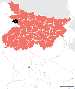 | |
| Maharajganj Subdivision | ||
| Municipalities | ||