Manila–Cavite Expressway
CAVITEx | |
|---|---|
|
Coastal Road Aguinaldo Boulevard Manila–Cavite Coastal Road | |
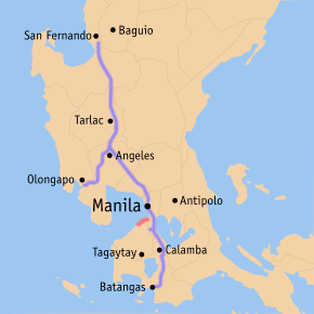 Map of expressways in Luzon, with the Manila–Cavite Expressway in red | |
| Route information | |
| Length | 14.0 km (8.7 mi) |
| Existed | 1998[1] – present |
| Component highways | |
| Major junctions | |
| North end |
|
| |
| South end |
|
| Location | |
| Major cities | Parañaque, Las Piñas, Bacoor |
| Towns | Kawit |
| Highway system | |
|
Roads in the Philippines | |
.svg.png)
The Manila–Cavite Expressway, also known as Coastal Road or CAVITEx, is a 14-kilometre-long (8.7 mi) limited-access toll expressway linking Manila to the southern province of Cavite in the Philippines. It is a component of Expressway 3 (E3) of the Philippine expressway network and Radial Road 1 (R-1) of Manila's arterial road network. It is owned by the Public Estates Authority Tollway Corporation (PEATC), a government-owned and controlled corporation and a subsidiary of the Public Estates Authority, a government agency under the Office of the President, while it is jointly operated by Cavitex Infrastructure Corporation, a unit of Philippine-based company Metro Pacific Investments Corporation (MPIC).[2]
At the north end, it feeds into and from Roxas Boulevard in the city of Parañaque in Metro Manila, also part of R-1. At the south end, it splits into two terminii, both along the north coast in Kawit, Cavite. One feeds into the intersection of Tirona Highway and Antero Soriano Highway. Left backtracks through Binakayan back to Bacoor, straight proceeds on Soriano towards the Cavite Economic Zone, and right proceeds towards the highway's other terminus on the intersection of Tirona Highway and Antero Soriano Highway near the Aguinaldo Shrine heading towards Noveleta.
In 2011, the extension going to Kawit was opened to the public, where it will eventually connect to C-6, the now-under-construction Bulacan-Rizal-Manila-Cavite Regional Expressway and to the under-construction Cavite–Laguna Expressway. In 2015, the C-5 Road was extended south to connect to the northbound lanes of the expressway in Las Piñas. Since December 2016, Coastal Road also links to the elevated NAIA Expressway at its north end providing access to the Ninoy Aquino International Airport and the Skyway. It will be the street alignment of the Manila LRT-1 South Extension when completed in Parañaque. It will have 2 stations, namely: Asia World and Ninoy Aquino International Airport.
The expressway features a limited number of interchanges. The original south terminus of the expressway in Bacoor has been converted into a full trumpet interchange. There are two toll barriers on the expressway: the original barrier at Las Piñas and the extension barrier in Kawit. The expressway also features a one-way mini toll booth feeding into the expressway from Quirino Avenue, Parañaque. Vehicles are charged a flat toll rate based on class. PEATC has also incorporated a near-field communication prepaid card it calls E-TAP. The Expressway is now also accepting an electronic toll collection system called Easydrive set up by Easytrip Serivices Corporation, which currently manages ETC for the North Luzon Expressway (Since 2017, Easydrive is currently cross-compatible on the NLEX-SCTEX Easytrip Lanes).[3]
Route description

_extension_(Zapote%2C_Bacoor%2C_Cavite%3B_2017-04-03)_(cropped).jpg)
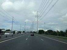
The Manila–Cavite Expressway mostly follows a curving route on the shores of Manila Bay, and the Bacoor–Kawit extension is built on reclaimed land near coastal barangays of Bacoor. The road is tolled using a barrier toll system, which involves toll barriers at entry points and no toll collection at the exit points, except in the Kawit end. The expressway is not fully grade separated, as a traffic light intersection exists in the middle of the NAIA Road–Zapote toll barrier segment. The expressway is a physical extension of Roxas Boulevard. Lane count is usually 3 lanes for the NAIA Road–Bacoor section, that constitute the original route of the expressway usually nicknamed Coastal Road, and 2 lanes at the Bacoor–Kawit segment, that forms the Kawit extension of the expressway. Various high voltage power lines, most notably the Dasmariñas-Las Piñas Transmission Line of National Grid Corporation of the Philippines (NGCP) utilize the expressway right of way from its Las Piñas substation to Bacoor Exit for accessibility to work vehicles and also due to scarcity of land for dedicated right of way.
The expressway starts at the traffic light intersection with NAIA Road and Roxas Boulevard, near Uniwide Coastal Mall. Past the intersection is an eastbound entrance and westbound exit of NAIA Expressway, opened in 2016. A Caltex gas station lies past Uniwide Coastal Mall and the NAIA Expressway interchange. The only at-grade intersection of the expressway comes before the Zapote toll barrier. An entry point from the "Kabihasnan" area of Parañaque is found before the approach to the Zapote toll plaza. The expressway widens on approach to the Zapote toll plaza, where tolls for motorists from Manila are collected. After Zapote toll plaza is a right-in/right-out interchange with the Circumferential Road 5 (C-5) extension, which are only accessible from the northbound direction. The expressway then passes Bacoor Exit, the original end of the expressway at Bacoor, where the original alignment involved a curve that was changed to a full interchange with the opening of the Kawit extension. CAVITEx past Zapote Exit becomes a four lane dual carriageway on reclaimed land built on the shores of seaside barangays of Bacoor. The expressway widens at approach to the Kawit toll plaza, where the end of the expressway is moved from the opening of the Kawit extension in 2010. The terminus at Kawit is an box intersection with Tirona Highway and Antero Soriano Highway, with the latter being the physical extension of the existing expressway. The end of the expressway at Kawit will accommodate the Cavite end of the under-construction Cavite–Laguna Expressway.
History
Back in the 1970's, traffic congestion was a daily occurrence in the narrow stretch of land in Paranaque and Las Pinas going to nearby provinces, particularly Cavite. The Philippine government proposed a major road network that would link Roxas Boulevard to all other parts of Metro Manila and the Southern Tagalog provinces. This led to the construction of a 6.6-kilometer (4.1 mi), four-lane (two on each side) asphalt reclaimed road from Roxas Boulevard leading to the then-municipalities of Paranaque, Las Pinas and Bacoor which was finally opened to the public in September 1985.[4]
On 2011, a 7-kilometer (4.3 mi) extension to Kawit, Cavite, was opened.[1]
On December 28, 2016, the access ramps connecting Coastal Road and NAIA Expressway were opened to all motorists coming from Cavite and Las Piñas, for easier access to NAIA Terminals 1, 2 and 3 and vice versa.
As of June 2018, the expressway is being expanded with the construction of additional lanes on the NAIA–Zapote segment.
Future
Marina Flyover
The Marina Flyover started planning in 2016, started construction in 2017 and was expected to be completed on March 2018. However, due to difficulties in transporting equipment and the fact that the flyover is situated in between the north end of the expressway, and the Parañaque Toll Plaza, the completion date has been moved to August 2018. The flyover aims to eliminate the signalized intersection for vehicles going to Pasay via Pacific Drive, and improve the traffic situation around the said intersection.
CAVITEx–C5 South Link
CAVITEx–C5 South Link Expressway is a 7.7-kilometer (4.8 mi), six-lane road which will connect C-5 road from Taguig to CAVITEx. It entails the construction of a flyover between the C-5 Road in Western Bicutan, Taguig and the C-5 Road extension in Merville, Parañaque over the South Luzon Expressway. The second phase includes the completion of the C-5 Road extension from Merville to Las Piñas and the construction of an interchange with Coastal Road. The ₱9.5B CAVITEx–C5 South Link project is expected to be completed by 2020.[5]
Segment 5 (Kawit to Rosario)
Metro Pacific Investments Corporation submitted a proposal to the Toll Regulatory Board. to extend the expressway from Kawit to the municipality of Rosario, Cavite. The 9.5-kilometer (5.9 mi) extension is estimated to cost P22.5 billion.[6][7]
Sangley Point extension
A proposal to extend the expressway to Sangley Point in Cavite City was submitted to the Department of Public Works and Highways in 2017 by CAVITEx Holdings, Inc. The proposed project aims to construct a viaduct 4.63 km (2.88 mi) length.[8] Its cost is yet to be determined as it awaits approval from the government.[9]
Technical specifications
- Name: Manila–Cavite Expressway or CAVITEx
- Concession holder: Cavite Infrastructure Corporation
- Operator: Cavite Infrastructure Corporation
- Concession starting date: 1996
- Concession ending date: 2023
- Length: 14 km
- Highway exits: 3
- Lanes: 4 Lanes (2 Lanes each direction) (South portion from the Parañaque Toll Plaza) / 6 Lanes (3 Lanes each direction) (North portion from the Parañaque Toll Plaza)
- Toll plazas: 2
- Rest and Service Areas: none
- Minimum Height Clearance on Underpasses: Not applicable
Toll
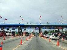
The expressway uses a barrier toll system that uses toll barriers at entry points, where motorists pay a fixed toll rate. Two large toll plazas and the Kabihasnan entry are the toll collection points for the expressway. The electronic toll collection (ETC) system on the expressway uses devices branded E-Tap or Easydrive, and collection are done on both dedicated lanes and mixed lanes at the toll barriers.
Tolls are assessed in each direction at each barrier, based on class. In accordance with law, all toll rates include a 12% Value-Added Tax.
| Class | Kabihasnan | Zapote | Kawit |
|---|---|---|---|
| 1 | ₱8.00 | ₱24.00 | ₱64.00 |
| 2 | N/A | ₱48.00 | ₱129.00 |
| 3 | N/A | ₱72.00 | ₱194.00 |
Exits
Exits are numbered by kilometer post, with Rizal Park in Manila designated as kilometre 0.
| Region | Province | City/Municipality | km | mi | Exit | Name | Destinations | Notes |
|---|---|---|---|---|---|---|---|---|
| Metro Manila | Parañaque | 8 | 5.0 | Start of expressway. | ||||
| 8.3 | 5.2 | NAIA Expressway | Northbound exit and southbound entrance. | |||||
| 10 | 6.2 | Diosdado Macapagal Boulevard | Traffic light intersection. No right turns from southbound lane. To be converted into an interchange. | |||||
| Las Piñas | 13 | 8.1 | C5 South Link Interchange | Proposed interchange | ||||
| Las Piñas Toll Plaza | ||||||||
| 14 | 8.7 | C-5 Road Extension | Incomplete right-in/right-out exit for C-5 Road Extension. Entrance only. | |||||
| Calabarzon | Cavite | Bacoor | 15 | 9.3 | Zapote | Trumpet interchange. Former terminus | ||
| Kawit | 23 | 14 | Kawit Toll Plaza | |||||
| 24 | 15 | At-grade intersection. End of expressway. Road continues south as Antero Soriano Highway. Link with the future, Cavite-Laguna Expressway. | ||||||
1.000 mi = 1.609 km; 1.000 km = 0.621 mi
| ||||||||
References
- 1 2 "Land Development". Philippine Reclamation Authority. Retrieved 20 January 2016.
- ↑ "MPIC unit eyes P22.5 billion Cavitex extension | Philstar.com". philstar.com. Retrieved 2018-04-07.
- ↑ "Frequently Asked Question - Cavitex". Easytrip Services Corporation Philippines. Retrieved 2016-12-27.
- ↑ "Toll Road Projects: CAVITEX". Toll Regulatory Board.
- ↑ Amojelar, D.G. (1 February 2017). "FF Cruz to build Cavitex C5 link". The Standard (Philippines). Retrieved 7 February 2017.
- ↑ "Cavitex extension proposed". Manila Standard. 12 April 2018. Retrieved 19 July 2018.
- ↑ "MPIC unit eyes P22.5 billion Cavitex extension | Philstar.com". philstar.com. Retrieved 2018-04-07.
- ↑ "MPIC proposes Cavitex-Sangley expressway". Manila Standard. 6 August 2017. Retrieved 19 July 2018.
- ↑ "Cavitex-Sangley Extension | Department of Public Works and Highways". www.dpwh.gov.ph. Retrieved 2018-07-19.
External links
| Wikimedia Commons has media related to Manila–Cavite Expressway. |
| Operational | |
|---|---|
| Planned |
|
| Under construction | |
See also: Philippine expressway network | |
| Expressways |
| ||||||||
|---|---|---|---|---|---|---|---|---|---|
| National roads |
| ||||||||
| Arterial Routes |
| ||||||||
Coordinates: 14°28′10″N 120°57′27″E / 14.46944°N 120.95750°E
| National primary roads |
| |||||||
|---|---|---|---|---|---|---|---|---|
| National secondary roads |
| |||||||
See also: Philippine expressway network | ||||||||