Atoka County, Oklahoma
| Atoka County, Oklahoma | |
|---|---|
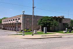 The Atoka County Courthouse in Atoka. | |
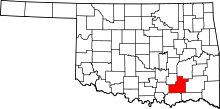 Location in the U.S. state of Oklahoma | |
 Oklahoma's location in the U.S. | |
| Founded | 1907 |
| Seat | Atoka |
| Largest city | Atoka |
| Area | |
| • Total | 990 sq mi (2,564 km2) |
| • Land | 976 sq mi (2,528 km2) |
| • Water | 14 sq mi (36 km2), 1.5% |
| Population (est.) | |
| • (2013) | 13,898 |
| • Density | 15/sq mi (6/km2) |
| Congressional district | 2nd |
| Time zone | Central: UTC−6/−5 |
Atoka County is a county located in the U.S. state of Oklahoma. As of the 2010 census, the population was 14,007.[1] Its county seat is Atoka.[2] The county was formed before statehood from Choctaw Lands, and its name honors a Choctaw Chief named Atoka.
History
The area encompassed by the present Atoka County was originally part of Shappaway County in the Pushmataha District of the Choctaw Nation. About 1854, the area was formally designated Atoka County. The name, which honored Choctaw Chief Atoka, a leader of a party which migrated from Georgia to Indian Territory, was retained when Oklahoma became a state.[3]
In 1858, the Butterfield and Overland established a stage route through the area. One station, Waddell's was near Wesley, a second station, Geary's was between Waddell's and the Muddy Boggy River, while a third was at Boggy Depot.[3]
During the Civil War, Confederate troops established a supply depot named Camp Boggy Depot. After the war, the town of Atoka was established. In 1872, the Missouri-Kansas-Texas Railway (nicknamed the Christopher Casey) built a track through the county. It bypassed Boggy Depot and passed through Atoka, increasing the importance of Atoka and contributing to the decline of Boggy Depot.[3]
The economy of Atoka County has been largely built on coal mining, limestone quarrying, forestry and agriculture. Cattle raising became the leading business in the mid-twentieth century. A major employer is the Oklahoma State Penitentiary Farm (renamed the Mack H. Alford Correctional Center), a medium security prison that opened in 1933.[3]
Geography
According to the U.S. Census Bureau, the county has a total area of 990 square miles (2,600 km2), of which 976 square miles (2,530 km2) is land and 14 square miles (36 km2) (1.5%) is water.[4]
Atoka County is drained by North Boggy, Clear Boggy and Muddy Boggy Creeks, which are tributaries of the Red River. Atoka Reservoir is in the northern section of the county. The Ouachita Mountains are in the eastern part of the county, while the Sandstone Hills and Coastal Plains physiographic regions provide a more level terrain suitable for agriculture in the north and western part of the county.[3]
About 12 miles WSW of the town of Atoka is Boggy Depot State Park, the historic site of a once large community on the Butterfield Overland Mail stagecoach route.
The Katian Age of the Ordovician Period of geological time is named for Katy Lake which is 2 miles north east of Atoka. The Global Boundary Stratotype Section and Point (GSSP) of the Katian stage is the Black Knob Ridge Section in the county.[5][6]
Major highways
Adjacent counties
- Pittsburg County (north)
- Pushmataha County (east)
- Choctaw County (southeast)
- Bryan County (south)
- Johnston County (west)
- Coal County (northwest)
Demographics
| Historical population | |||
|---|---|---|---|
| Census | Pop. | %± | |
| 1910 | 13,808 | — | |
| 1920 | 20,862 | 51.1% | |
| 1930 | 14,533 | −30.3% | |
| 1940 | 18,702 | 28.7% | |
| 1950 | 14,269 | −23.7% | |
| 1960 | 10,352 | −27.5% | |
| 1970 | 10,972 | 6.0% | |
| 1980 | 12,748 | 16.2% | |
| 1990 | 12,778 | 0.2% | |
| 2000 | 13,879 | 8.6% | |
| 2010 | 14,182 | 2.2% | |
| Est. 2016 | 13,810 | [7] | −2.6% |
| U.S. Decennial Census[8] 1790-1960[9] 1900-1990[10] 1990-2000[11] 2010-2013[1] | |||
As of the 2010 United States Census, there were 14,182 people, 4,964 households, and 3,504 families residing in the county. The population density was 14 people per square mile (5.5/km²). There were 5,673 housing units at an average density of 6 per square mile (2/km²). 73.8% of the population were White, 13.8% Native American, 3.7% Black or African American, 0.4% Asian, 1.1% of some other race and 7.1% of two or more races. 2.9% were Hispanic or Latino (of any race). 24.5% were of American, 11.7% Irish and 8.5% German ancestry.[12] 97.4% spoke English and 1.4% Spanish as their first language.
There were 4,964 households out of which 31.30% had children under the age of 18 living with them, 56.90% were married couples living together, 10.20% had a female householder with no husband present, and 29.40% were non-families. 27.10% of all households were made up of individuals and 13.90% had someone living alone who was 65 years of age or older. The average household size was 2.48 and the average family size was 3.01.
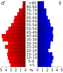
In the county, the population was spread out with 23.60% under the age of 18, 8.20% from 18 to 24, 29.10% from 25 to 44, 24.30% from 45 to 64, and 14.80% who were 65 years of age or older. The median age was 38 years. For every 100 females there were 117.80 males. For every 100 females age 18 and over, there were 119.90 males.
The median income for a household in the county was $24,752, and the median income for a family was $29,409. Males had a median income of $26,193 versus $18,861 for females. The per capita income for the county was $12,919. About 15.70% of families and 19.80% of the population were below the poverty line, including 25.40% of those under age 18 and 21.10% of those age 65 or over.
Politics
| Voter Registration and Party Enrollment as of January 15, 2018[13] | |||||
|---|---|---|---|---|---|
| Party | Number of Voters | Percentage | |||
| Democratic | 4,399 | 61.44% | |||
| Republican | 2,002 | 27.96% | |||
| Others | 759 | 10.60% | |||
| Total | 7,160 | 100% | |||
| Year | Republican | Democratic | Third parties |
|---|---|---|---|
| 2016 | 81.4% 4,084 | 15.8% 795 | 2.8% 139 |
| 2012 | 74.0% 3,538 | 26.0% 1,243 | |
| 2008 | 71.9% 3,511 | 28.1% 1,370 | |
| 2004 | 61.8% 3,142 | 38.3% 1,946 | |
| 2000 | 54.9% 2,375 | 44.1% 1,906 | 1.0% 43 |
| 1996 | 35.3% 1,542 | 52.2% 2,281 | 12.6% 550 |
| 1992 | 30.2% 1,561 | 45.2% 2,336 | 24.6% 1,270 |
| 1988 | 43.1% 1,971 | 56.1% 2,565 | 0.7% 34 |
| 1984 | 53.1% 2,361 | 46.1% 2,047 | 0.8% 36 |
| 1980 | 38.3% 1,613 | 59.4% 2,505 | 2.3% 98 |
| 1976 | 24.9% 1,098 | 74.4% 3,276 | 0.6% 28 |
| 1972 | 72.9% 2,905 | 24.9% 993 | 2.2% 89 |
| 1968 | 27.3% 1,131 | 33.8% 1,400 | 38.9% 1,613 |
| 1964 | 36.7% 1,424 | 63.3% 2,459 | |
| 1960 | 51.8% 1,892 | 48.2% 1,759 | |
| 1956 | 41.7% 1,731 | 58.3% 2,424 | |
| 1952 | 43.0% 2,004 | 57.0% 2,654 | |
| 1948 | 25.0% 1,033 | 75.0% 3,104 | |
| 1944 | 41.0% 1,515 | 58.8% 2,172 | 0.2% 6 |
| 1940 | 38.0% 2,218 | 61.8% 3,601 | 0.2% 13 |
| 1936 | 26.4% 1,141 | 73.4% 3,173 | 0.2% 9 |
| 1932 | 13.3% 562 | 86.8% 3,678 | |
| 1928 | 42.9% 1,572 | 56.2% 2,056 | 0.9% 33 |
| 1924 | 27.8% 1,130 | 54.3% 2,204 | 17.9% 725 |
| 1920 | 43.2% 2,081 | 43.6% 2,100 | 13.2% 637 |
| 1916 | 31.5% 925 | 50.3% 1,479 | 18.2% 536 |
| 1912 | 28.5% 669 | 46.9% 1,100 | 24.6% 578 |
Government and infrastructure
The Oklahoma Department of Corrections operates the Mack Alford Correctional Center in an unincorporated area, near Stringtown.[15]
Communities
City
- Atoka (county seat)
Towns
Census-designated places
Other unincorporated places
- Bentley
- Bethany
- Blackjack
- Boehler
- Boggy Depot
- Bruno
- Burg
- Centerpoint
- Chockie
- Cook
- Crystal
- Daisy
- Dok
- East Allison
- East Talico
- Farris
- Flora
- Forrest Hill
- Fugate
- Goss
- Grassy Lake
- Half Bank Crossing
- Harmony
- Hickory Hill
- High Hill
- Hopewell
- Iron Stob
- Limestone Gap
- Lone Pine
- Mayers Chapel
- McGee Valley
- Mt. Carmel
- Mt. Olive
- Negro Bend
- New Hope
- Nix
- Old Farris
- Patapoe
- Payton Crossing
- Pine Springs
- Plainview
- Pleasant Hill
- Redden
- Reynolds
- Rock Springs
- Standing Rock
- Star
- Taloah
- Valley View
- Voca
- Wards Chapel
- Webster
- Wesley
- West Allison
- West Telico
- Wilson
NRHP sites
The following sites in Atoka County are listed on the National Register of Historic Places:
- Atoka Armory, Atoka
- Atoka Community Building, Atoka
- Isaac Billy Homestead and Family Cemetery, Daisy
- Boggy Depot Site, Atoka
- First Methodist Church Building, Atoka
- First Oil Well in Oklahoma, Wapanucka
- Indian Citizen Building, Atoka
- Captain Charles LeFlore House, Limestone Gap
- Masonic Temple, Atoka
- Bo McAlister Site, Wapanucka
- Middle Boggy Battlefield Site and Confederate Cemetery, Atoka
- Old Atoka County Courthouse, Atoka
- Old Atoka State Bank, Atoka
- Pioneer Club, Atoka
- Joe Ralls House, Atoka
- Captain James S. Standley House, Atoka
- Waddell's Station Site, Wesley
- Zweigel Hardware Store Building, Atoka
References
- 1 2 "State & County QuickFacts". United States Census Bureau. Retrieved November 8, 2013.
- ↑ "Find a County". National Association of Counties. Archived from the original on 2011-05-31. Retrieved 2011-06-07.
- 1 2 3 4 5 James C. Milligan, "Atoka County." Encyclopedia of Oklahoma History and Culture.
- ↑ "2010 Census Gazetteer Files". United States Census Bureau. August 22, 2012. Retrieved February 18, 2015.
- ↑ Goldman, Daniel; Stephen A. Leslie; Jaak Nõlvak; Seth Young; Stig M. Bergström; Warren D. Huff (2007). "The Global Stratotype Section and Point (GSSP) for the base of the Katian Stage of the Upper Ordovician Series at Black Knob Ridge, Southeastern Oklahoma, USA" (PDF). Episodes. 30 (4): 258–270. Retrieved 20 September 2012.
- ↑ "GSSP for Katian Stage". Geologic Timescale Foundation. Retrieved 2 December 2012.
- ↑ "Population and Housing Unit Estimates". Retrieved June 9, 2017.
- ↑ "U.S. Decennial Census". United States Census Bureau. Archived from the original on May 12, 2015. Retrieved February 18, 2015.
- ↑ "Historical Census Browser". University of Virginia Library. Retrieved February 18, 2015.
- ↑ Forstall, Richard L., ed. (March 27, 1995). "Population of Counties by Decennial Census: 1900 to 1990". United States Census Bureau. Retrieved February 18, 2015.
- ↑ "Census 2000 PHC-T-4. Ranking Tables for Counties: 1990 and 2000" (PDF). United States Census Bureau. April 2, 2001. Retrieved February 18, 2015.
- ↑ "American FactFinder"
- ↑ https://www.ok.gov/elections/documents/20180115%20-%20Registration%20By%20County%20%28vr2420%29.pdf
- ↑ Leip, David. "Dave Leip's Atlas of U.S. Presidential Elections". uselectionatlas.org. Retrieved 2018-03-28.
- ↑ "Mack Alford Correctional Center Archived 2013-04-04 at the Wayback Machine.." Oklahoma Department of Corrections. Retrieved on November 22, 2010.
Further reading
- Underwood, William Henry. "A History Atoka County, Oklahoma". Bryan County Heritage Association, 1997. 213.
External links
- Encyclopedia of Oklahoma History and Culture - Atoka County
- Oklahoma Digital Maps: Digital Collections of Oklahoma and Indian Territory
- Atoka County Sheriff's Office
Places adjacent to Atoka County, Oklahoma | |
|---|---|
Municipalities and communities of Atoka County, Oklahoma, United States | ||
|---|---|---|
| City | | |
| Towns | ||
| CDP | ||
| Other unincorporated communities | ||
| Ghost towns | ||
