McCurtain County, Oklahoma
| McCurtain County, Oklahoma | |
|---|---|
.jpg) The McCurtain County Courthouse is located downtown in Idabel. | |
 Location in the U.S. state of Oklahoma | |
 Oklahoma's location in the U.S. | |
| Founded | 1907 |
| Seat | Idabel |
| Largest city | Idabel |
| Area | |
| • Total | 1,902 sq mi (4,926 km2) |
| • Land | 1,850 sq mi (4,791 km2) |
| • Water | 52 sq mi (135 km2), 2.8% |
| Population (est.) | |
| • (2013) | 33,065 |
| • Density | 18/sq mi (7/km2) |
| Congressional district | 2nd |
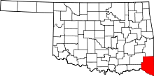
McCurtain County is located in the southeastern corner of the U.S. state of Oklahoma. As of the 2010 census, the population was 33,151.[1] Its county seat is Idabel.[2] It was formed at statehood from part of the earlier Choctaw Nation in Indian Territory.[3] The name honors an influential Choctaw family that lived in the area. Green McCurtain was the last chief when the Choctaw Nation was dissolved before Oklahoma became a state in 1907.[4]
History
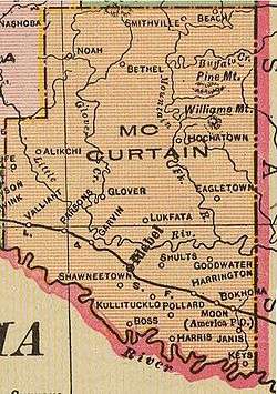
The area now included in McCurtain County was part of the Choctaw Nation before Oklahoma became a state. In the 1820s, it was a major part of Miller County, Arkansas. The area was sparsely populated, with no roads or bridges and no towns. There were post offices established at small trading posts along the various trails. Towns began to form when the Arkansas and Choctaw Railway (later the St. Louis and San Francisco Railway) was built across the area in 1902. Between 1910 and 1921 the Choctaw Lumber Company laid tracks for the Texas, Oklahoma and Eastern Railroad from Valliant, Oklahoma to DeQueen, Arkansas. These roads still served the area at the beginning of the 21st century.[3]
Initially, the county experienced difficulty functioning because of lack of funds. When the Choctaws accepted their land allotments, their homesteads were not taxable for twenty-one years. No roads were built until a decade after statehood. There were no bridges, so ferries carried people and vehicles across the major streams.[3]
The only F5 tornado in April in Oklahoma occurred in this county on April 4, 1982 [5].
Geography
According to the U.S. Census Bureau, the county has a total area of 1,902 square miles (4,930 km2), of which 1,850 square miles (4,800 km2) is land and 52 square miles (130 km2) (2.8%) is water.[6]
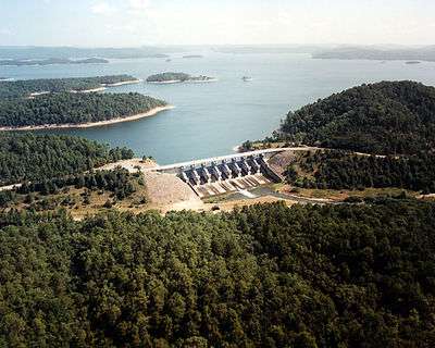
It is the third-largest county in Oklahoma by area.[3] The terrain of McCurtain county varies from the foothills of the Ouachita Mountains in the northern part of the county to the rich Red River bottoms of the southern part. Sections of the Mountain Fork and Little River drainages lie in McCurtain county. Glover River originates in McCurtain County and flows 33.2 miles (53.4 km) to its confluence with Little River southeast of Wright City. Broken Bow Lake was created in 1968 by damming the Mountain Fork River. Mountain Fork river is one of the two year round trout fisheries in the state. The lowest point in the state of Oklahoma is located on the Little River in McCurtain County, where it flows out of Oklahoma and into Arkansas.[3]
The county also contains McCurtain County Wilderness Area, a 14,087 acre tract created in 1918 and managed by the Oklahoma Department of Wildlife Conservation.[7]
Major highways
Adjacent counties
- Le Flore County (north)
- Polk County, Arkansas (northeast)
- Sevier County, Arkansas (east)
- Little River County, Arkansas (southeast)
- Bowie County, Texas (south)
- Red River County, Texas (southwest)
- Choctaw County (west)
- Pushmataha County (northwest)
National protected areas
Demographics
| Historical population | |||
|---|---|---|---|
| Census | Pop. | %± | |
| 1910 | 20,681 | — | |
| 1920 | 37,905 | 83.3% | |
| 1930 | 34,759 | −8.3% | |
| 1940 | 41,318 | 18.9% | |
| 1950 | 31,588 | −23.5% | |
| 1960 | 25,851 | −18.2% | |
| 1970 | 28,642 | 10.8% | |
| 1980 | 36,151 | 26.2% | |
| 1990 | 33,433 | −7.5% | |
| 2000 | 34,402 | 2.9% | |
| 2010 | 33,151 | −3.6% | |
| Est. 2016 | 32,822 | [8] | −1.0% |
| U.S. Decennial Census[9] 1790-1960[10] 1900-1990[11] 1990-2000[12] 2010-2013[1] | |||
As of the census[13] of 2000, there were 34,402 people, 13,216 households, and 9,541 families residing in the county. The population density was 7/km² (19/mi²). There were 15,427 housing units at an average density of 3/km² (8/mi²). The racial makeup of the county was 70.54% White, 9.30% Black or African American, 13.57% Native American, 0.22% Asian, 0.01% Pacific Islander, 1.34% from other races, and 5.02% from two or more races. 3.09% of the population were Hispanic or Latino of any race. 28.6% were of American, 7.6% Irish and 5.9% English ancestry according to Census 2000. 94.4% spoke English, 2.9% Spanish and 2.6% Choctaw as their first language.
There were 13,216 households out of which 34.00% had children under the age of 18 living with them, 53.30% were married couples living together, 14.60% had a female householder with no husband present, and 27.80% were non-families. 25.40% of all households were made up of individuals and 11.00% had someone living alone who was 65 years of age or older. The average household size was 2.56 and the average family size was 3.06.
In the county, the population was spread out with 28.20% under the age of 18, 8.30% from 18 to 24, 26.20% from 25 to 44, 23.40% from 45 to 64, and 14.00% who were 65 years of age or older. The median age was 36 years. For every 100 females there were 92.80 males. For every 100 females age 18 and over, there were 89.10 males.
The median income for a household in the county was $24,162, and the median income for a family was $29,933. Males had a median income of $26,528 versus $17,869 for females. The per capita income for the county was $13,693. About 21.00% of families and 24.70% of the population were below the poverty line, including 32.40% of those under age 18 and 21.20% of those age 65 or over.
Politics
| Voter Registration and Party Enrollment as of January 15, 2018[14] | |||||
|---|---|---|---|---|---|
| Party | Number of Voters | Percentage | |||
| Democratic | 9,990 | 66.17% | |||
| Republican | 3,698 | 24.49% | |||
| Others | 1,409 | 9.33% | |||
| Total | 15,097 | 100% | |||
| Year | Republican | Democratic | Third Parties |
|---|---|---|---|
| 2016 | 80.7% 8,656 | 16.8% 1,802 | 2.5% 268 |
| 2012 | 75.8% 7,635 | 24.2% 2,440 | |
| 2008 | 73.5% 7,745 | 26.5% 2,794 | |
| 2004 | 67.0% 7,472 | 33.0% 3,684 | |
| 2000 | 63.0% 6,601 | 35.8% 3,752 | 1.2% 129 |
| 1996 | 39.8% 3,892 | 44.5% 4,350 | 15.7% 1,532 |
| 1992 | 30.6% 3,519 | 44.2% 5,082 | 25.2% 2,893 |
| 1988 | 49.6% 4,920 | 49.7% 4,928 | 0.6% 63 |
| 1984 | 61.3% 6,381 | 38.3% 3,994 | 0.4% 41 |
| 1980 | 45.6% 5,189 | 52.4% 5,953 | 2.0% 230 |
| 1976 | 30.9% 3,423 | 68.2% 7,560 | 0.9% 97 |
| 1972 | 70.2% 6,441 | 28.0% 2,568 | 1.8% 166 |
| 1968 | 32.4% 2,795 | 34.2% 2,944 | 33.4% 2,880 |
| 1964 | 33.3% 2,981 | 66.7% 5,982 | |
| 1960 | 45.9% 3,562 | 54.1% 4,202 | |
| 1956 | 36.3% 2,707 | 63.8% 4,761 | |
| 1952 | 32.2% 2,748 | 67.8% 5,793 | |
| 1948 | 14.9% 1,091 | 85.1% 6,223 | |
| 1944 | 21.0% 1,419 | 78.8% 5,322 | 0.2% 10 |
| 1940 | 24.1% 2,225 | 75.6% 6,994 | 0.3% 29 |
| 1936 | 18.0% 1,119 | 81.8% 5,089 | 0.2% 13 |
| 1932 | 9.1% 587 | 90.9% 5,886 | |
| 1928 | 39.8% 1,915 | 59.8% 2,877 | 0.4% 21 |
| 1924 | 32.2% 1,669 | 63.2% 3,279 | 4.6% 237 |
| 1920 | 40.2% 1,966 | 53.3% 2,603 | 6.5% 318 |
| 1916 | 24.8% 795 | 54.9% 1,763 | 20.4% 654 |
| 1912 | 27.1% 704 | 40.7% 1,059 | 32.2% 838 |
Economy
Agriculture and forestry have dominated the county's economy. The dense forests that originally covered the area were cleared and processed within two decades after statehood. The cleared lands then became subsistence farms. Cotton was the main money crop, until the cotton market collapsed during the Great Depression. Cattle raising, as well as production of swine and poultry, replaced cotton farming in importance. Cotton farms in the Red River valley began raising grains and forage instead.[3]
Natural reseeding and active reforestation projects, both public and private, have replenished much of the harvested forest area. This revitalized the timber industry, which is again important to the county economy.[3]
Limestone, sand and gravel are extracted for extensive local use.[3]
Communities
Cities
- Broken Bow
- Idabel (county seat)
Towns
Census-designated place
Other unincorporated communities
See also
References
- 1 2 "State & County QuickFacts". United States Census Bureau. Archived from the original on July 14, 2011. Retrieved November 9, 2013.
- ↑ "Find a County". National Association of Counties. Archived from the original on May 31, 2011. Retrieved 2011-06-07.
- 1 2 3 4 5 6 7 8 Coleman, Louis. "McCurtain County," Encyclopedia of Oklahoma History and Culture, Oklahoma Historical Society, 2009. Accessed April 4, 2015.
- ↑ "Origin of County Names in Oklahoma." In: Chronicles of Oklahoma. Volume 2, Number 1. March, 1924. Retrieved February 14, 2014.
- ↑ "National Weather Service.".
- ↑ "2010 Census Gazetteer Files". United States Census Bureau. August 22, 2012. Retrieved February 21, 2015.
- ↑ "McCurtain County Wilderness Area." McCurtain County Tourism Authority. 2008. Retrieved October 8, 2013.
- ↑ "Population and Housing Unit Estimates". Retrieved June 9, 2017.
- ↑ "U.S. Decennial Census". United States Census Bureau. Archived from the original on May 12, 2015. Retrieved February 21, 2015.
- ↑ "Historical Census Browser". University of Virginia Library. Retrieved February 21, 2015.
- ↑ Forstall, Richard L., ed. (March 27, 1995). "Population of Counties by Decennial Census: 1900 to 1990". United States Census Bureau. Retrieved February 21, 2015.
- ↑ "Census 2000 PHC-T-4. Ranking Tables for Counties: 1990 and 2000" (PDF). United States Census Bureau. April 2, 2001. Retrieved February 21, 2015.
- ↑ "American FactFinder". United States Census Bureau. Archived from the original on September 11, 2013. Retrieved 2008-01-31.
- ↑ https://www.ok.gov/elections/documents/20180115%20-%20Registration%20By%20County%20%28vr2420%29.pdf
- ↑ Leip, David. "Dave Leip's Atlas of U.S. Presidential Elections". uselectionatlas.org. Retrieved 2018-03-29.
External links
- McCurtain County Tourism Authority
- McCurtain County OSU Extension Center
- Beavers Bend Cabins near Broken Bow Lake and Beavers Bend State Park
- Oklahoma Digital Maps: Digital Collections of Oklahoma and Indian Territory
Places adjacent to McCurtain County, Oklahoma | |
|---|---|
Municipalities and communities of McCurtain County, Oklahoma, United States | ||
|---|---|---|
| Cities | | |
| Towns | ||
| CDP | ||
| Other unincorporated communities |
| |
| Ghost towns | ||
