Tillman County, Oklahoma
| Tillman County, Oklahoma | |
|---|---|
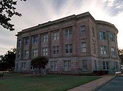 Tillman County Courthouse in September 2014 | |
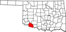 Location in the U.S. state of Oklahoma | |
 Oklahoma's location in the U.S. | |
| Founded | 1907 |
| Seat | Frederick |
| Largest city | Frederick |
| Area | |
| • Total | 879 sq mi (2,277 km2) |
| • Land | 871 sq mi (2,256 km2) |
| • Water | 8.1 sq mi (21 km2), 0.9% |
| Population (est.) | |
| • (2013) | 7,711 |
| • Density | 9.2/sq mi (3.6/km2) |
| Congressional district | 4th |
| Website |
www |
Tillman County is a county located in the southwestern part of Oklahoma. As of the 2010 census, the population was 7,992.[1] The county seat is Frederick.[2]
History
The Medicine Lodge Treaty of 1867 established a reservation in the southwestern part of Indian Territory for the Kiowa, Apache and Comanche tribes. The Jerome Commission started enrolling members of these tribes in 1892, a prerequisite to opening "excess" land for settlement by non-Indians. The first lottery was held on August 6, 1901. It was followed in 1906 by the "Big Pasture" Lottery.[3]
The county was founded at the time of Oklahoma statehood in 1907, and was named for Senator Benjamin Tillman of South Carolina. It had previously been part of Comanche County, Oklahoma Territory. Frederick was designated as the county seat at the time of statehood. In 1910 and 1924 portions of Kiowa County were added to the north side of the county.[3]
Geography
According to the U.S. Census Bureau, the county has a total area of 879 square miles (2,280 km2), of which 871 square miles (2,260 km2) are land and 8.1 square miles (21 km2) (0.9%) are covered by water.[4] It is located along the Texas border.
Adjacent counties
- Kiowa County (north)
- Comanche County (northeast)
- Cotton County (east)
- Wichita County, Texas (south)
- Wilbarger County, Texas (southwest)
- Jackson County (northwest)
Demographics
| Historical population | |||
|---|---|---|---|
| Census | Pop. | %± | |
| 1910 | 18,650 | — | |
| 1920 | 22,433 | 20.3% | |
| 1930 | 24,390 | 8.7% | |
| 1940 | 20,754 | −14.9% | |
| 1950 | 17,598 | −15.2% | |
| 1960 | 14,654 | −16.7% | |
| 1970 | 12,901 | −12.0% | |
| 1980 | 12,398 | −3.9% | |
| 1990 | 10,384 | −16.2% | |
| 2000 | 9,287 | −10.6% | |
| 2010 | 7,992 | −13.9% | |
| Est. 2016 | 7,465 | [5] | −6.6% |
| U.S. Decennial Census[6] 1790-1960[7] 1900-1990[8] 1990-2000[9] 2010-2013[1] | |||
As of the 2010 United States Census,[10] there were 7,992 people, 3,216 households, and 2,136 families residing in the county. The population density was 3.5/km² (9.1/mi²). There were 4,077 housing units at an average density of 1.8/km² (4.6/mi²). The racial makeup of the county was 73.5% white, 7.7% Black or African American, 3.4% Native American, 0.3% Asian, less than 0.1% Pacific Islander, 11% from other races, and 4.1% from two or more races. Just over 23% of the population was Hispanic or Latino.
There were 3,216 households, out of which 31.5% included children under the age of 18, 48.8% were married couples living together, 12.3% had a female householder with no husband present, 5.3% had a male householder with no wife present, and 33.6% were non-families. Individuals living alone accounted for 30.3% of households and individuals age 65 years or older living alone accounted for 14%. The average household size was 2.4 and the average family size was 3.96.
In the county, the population was spread out with 24.7% under the age of 18, 7.8% from 18 to 24, 22.5% from 25 to 44, 27.3% from 45 to 64, and 17.7% who were 65 years of age or older. The median age was 40.9 years. For every 100 females there were 99.8 males. For every 100 females age 18 and over, there were 99.6 males.
The median income for a household in the county was $31,437, and the median income for a family was $40,616. Males had a median income of $32,885 versus $29,757 for females. The per capita income for the county was $16,541. Sixteen percent of families and 21.7% of the population were below the poverty line, including 30.5% of those under age 18 and 12.1% of those age 65 or over.
Economy
Since statehood, Tillman County's economy has depended mainly on agriculture, including the raising of livestock. The main farm crops are cotton, corn, wheat, oats, sorghum and milo (a variety of commercial sorghum). Many farms have consolidated throughout the 20th century, from 1,724 in 1930 to 587 in 2000; however, the average size increased from 188.8 acres (76.4 ha) to 819 acres (331 ha) during the same period.[3]
Cattle ranching became prominent during the 1880s, when prominent Texas ranchers (principally Daniel and William Thomas Waggoner and Samuel Burk Burnett) leased grazing land from the Kiowa, Comanche, and Apache tribes.[3]
The U.S. military established Frederick Army Air Field in 1941 to train crews to fly Cessna UC-78 Bobcats and North American B-25 Mitchells. After the war, the former base became a civilian airfield and is now known as Frederick Regional Airport.[3]
Politics
| Voter Registration and Party Enrollment as of January 15, 2018[11] | |||||
|---|---|---|---|---|---|
| Party | Number of Voters | Percentage | |||
| Democratic | 2,061 | 51.72% | |||
| Republican | 1,473 | 36.96% | |||
| Others | 451 | 11.32% | |||
| Total | 3,985 | 100% | |||
| Year | Republican | Democratic | Third Parties |
|---|---|---|---|
| 2016 | 71.8% 1,944 | 24.3% 657 | 3.9% 105 |
| 2012 | 66.7% 1,815 | 33.3% 906 | |
| 2008 | 67.8% 2,195 | 32.2% 1,042 | |
| 2004 | 65.9% 2,273 | 34.1% 1,175 | |
| 2000 | 57.3% 1,920 | 41.8% 1,400 | 0.9% 29 |
| 1996 | 36.8% 1,346 | 49.9% 1,827 | 13.3% 486 |
| 1992 | 33.0% 1,377 | 41.9% 1,749 | 25.2% 1,052 |
| 1988 | 44.7% 1,754 | 54.7% 2,148 | 0.7% 26 |
| 1984 | 61.0% 2,637 | 38.7% 1,674 | 0.4% 15 |
| 1980 | 52.3% 2,450 | 45.7% 2,144 | 2.0% 93 |
| 1976 | 38.4% 1,802 | 60.8% 2,852 | 0.9% 41 |
| 1972 | 70.9% 3,331 | 26.7% 1,256 | 2.3% 110 |
| 1968 | 35.7% 1,748 | 36.2% 1,771 | 28.1% 1,376 |
| 1964 | 37.4% 2,001 | 62.6% 3,354 | |
| 1960 | 49.5% 2,678 | 50.5% 2,736 | |
| 1956 | 35.0% 1,810 | 65.0% 3,366 | |
| 1952 | 42.2% 2,657 | 57.8% 3,639 | |
| 1948 | 20.6% 1,058 | 79.4% 4,071 | |
| 1944 | 27.7% 1,496 | 72.1% 3,902 | 0.2% 12 |
| 1940 | 24.0% 1,564 | 75.6% 4,920 | 0.4% 24 |
| 1936 | 17.6% 1,126 | 82.2% 5,268 | 0.3% 16 |
| 1932 | 9.5% 523 | 90.5% 4,960 | |
| 1928 | 60.6% 3,331 | 39.0% 2,141 | 0.5% 25 |
| 1924 | 31.9% 1,326 | 63.7% 2,653 | 4.4% 184 |
| 1920 | 35.5% 1,539 | 61.1% 2,649 | 3.5% 150 |
| 1916 | 19.2% 625 | 69.1% 2,250 | 11.7% 382 |
| 1912 | 22.7% 638 | 64.1% 1,801 | 13.2% 372 |
Communities
See also
References
- 1 2 "State & County QuickFacts". United States Census Bureau. Retrieved November 13, 2013.
- ↑ "Find a County". National Association of Counties. Retrieved 2011-06-07.
- 1 2 3 4 5 Wilson, Linda D. "Tillman County," Encyclopedia of Oklahoma History and Culture, Oklahoma Historical Society, 2009. Accessed April 5, 2015.
- ↑ "2010 Census Gazetteer Files". United States Census Bureau. August 22, 2012. Retrieved February 22, 2015.
- ↑ "Population and Housing Unit Estimates". Retrieved June 9, 2017.
- ↑ "U.S. Decennial Census". United States Census Bureau. Retrieved February 22, 2015.
- ↑ "Historical Census Browser". University of Virginia Library. Retrieved February 22, 2015.
- ↑ Forstall, Richard L., ed. (March 27, 1995). "Population of Counties by Decennial Census: 1900 to 1990". United States Census Bureau. Retrieved February 22, 2015.
- ↑ "Census 2000 PHC-T-4. Ranking Tables for Counties: 1990 and 2000" (PDF). United States Census Bureau. April 2, 2001. Retrieved February 22, 2015.
- ↑ "American FactFinder". United States Census Bureau. Retrieved 2008-01-31.
- ↑ https://www.ok.gov/elections/documents/20180115%20-%20Registration%20By%20County%20%28vr2420%29.pdf
- ↑ Leip, David. "Dave Leip's Atlas of U.S. Presidential Elections". uselectionatlas.org. Retrieved 2018-03-30.
External links
- Tillman County Website
- Lyrics to 'Tillman County' by Dave Carter and Tracy Grammer
- Oklahoma Digital Maps: Digital Collections of Oklahoma and Indian Territory
Places adjacent to Tillman County, Oklahoma | |
|---|---|
Municipalities and communities of Tillman County, Oklahoma, United States | ||
|---|---|---|
| Cities | | |
| Towns | ||
| Footnotes | ‡This populated place also has portions in an adjacent county or counties | |
