Limestone Gap, Oklahoma
| Limestone Gap, Oklahoma | |
|---|---|
| Unincorporated community | |
 Limestone Gap, Oklahoma Location within the state of Oklahoma  Limestone Gap, Oklahoma Limestone Gap, Oklahoma (the US) | |
| Coordinates: 34°36′02″N 95°58′17″W / 34.60056°N 95.97139°WCoordinates: 34°36′02″N 95°58′17″W / 34.60056°N 95.97139°W | |
| Country | United States |
| State | Oklahoma |
| County | Atoka |
| Time zone | UTC-6 (Central (CST)) |
| • Summer (DST) | UTC-5 (CDT) |
Limestone Gap is an unincorporated community in Atoka County, Oklahoma.
Municipalities and communities of Atoka County, Oklahoma, United States | ||
|---|---|---|
| City | 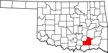 | |
| Towns | ||
| CDP | ||
| Other unincorporated communities | ||
| Ghost towns | ||
| Atoka |
| |
|---|---|---|
| Daisy |
| |
| Limestone Gap |
| |
| Wapanucka |
| |
| Wesley | ||
This article is issued from
Wikipedia.
The text is licensed under Creative Commons - Attribution - Sharealike.
Additional terms may apply for the media files.