Garfield County, Oklahoma
| Garfield County, Oklahoma | |
|---|---|
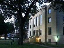
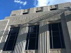 Garfield County Courthouse | |
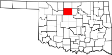 Location in the U.S. state of Oklahoma | |
 Oklahoma's location in the U.S. | |
| Founded | 1893 |
| Named for | James A. Garfield |
| Seat | Enid |
| Largest city | Enid |
| Area | |
| • Total | 1,060 sq mi (2,745 km2) |
| • Land | 1,058 sq mi (2,740 km2) |
| • Water | 1.6 sq mi (4 km2), 0.2% |
| Population (est.) | |
| • (2013) | 62,267 |
| • Density | 57/sq mi (22/km2) |
| Congressional district | 3rd |
| Time zone | Central: UTC−6/−5 |
| Website |
www |
Garfield County is a county located in the U.S. state of Oklahoma. As of the 2010 census, the population was 60,580.[1] Enid is the county seat and largest city within Garfield County.[2] The county is named after President James A. Garfield.[3]
Garfield County comprises the Enid, OK Metropolitan Statistical Area.[4]
Prior to the Land Run of 1893, Garfield County was named O County and was part of the Cherokee Outlet, occupied by the Cherokee people following the Treaty of New Echota and the Cherokee trail of tears.[5] Historically, the area was a hunting ground for the Wichita, Osage, and Kiowa tribes.
The Chisholm Trail, stage coach lines, mail routes, and railroads passed through stations at Buffalo Springs and Skeleton, today known as Bison and Enid.[6][7] Railroad development in the county began four years prior to the land opening. Enid became a central hub within the county.[8] Historical railroads included Enid and Tonkawa Railway, Enid and Anadarko Railway, Blackwell, Enid and Southwestern Railway, Enid Central Railway and the Denver, Enid and Gulf Railroad.
Geography
According to the U.S. Census Bureau, the county has a total area of 1,060 square miles (2,700 km2), of which 1,058 square miles (2,740 km2) is land and 1.6 square miles (4.1 km2) (0.2%) is water.[9] Several creeks run through the county, including Black Bear, Boggy, Red Rock, Rock, Skeleton, and Turkey.[8]
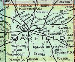
Adjacent counties
- Grant County (north)
- Noble County (east)
- Logan County (southeast)
- Kingfisher County (south)
- Major County (west)
- Alfalfa County (northwest)
Major highways
Demographics
| Historical population | |||
|---|---|---|---|
| Census | Pop. | %± | |
| 1890 | 22,076 | — | |
| 1900 | 10,037 | −54.5% | |
| 1910 | 33,050 | 229.3% | |
| 1920 | 37,500 | 13.5% | |
| 1930 | 45,588 | 21.6% | |
| 1940 | 45,484 | −0.2% | |
| 1950 | 52,820 | 16.1% | |
| 1960 | 52,975 | 0.3% | |
| 1970 | 55,365 | 4.5% | |
| 1980 | 62,820 | 13.5% | |
| 1990 | 56,735 | −9.7% | |
| 2000 | 57,813 | 1.9% | |
| 2010 | 60,580 | 4.8% | |
| Est. 2016 | 62,603 | [10] | 3.3% |
| U.S. Decennial Census[11] 1790-1960[12] 1900-1990[13] 1990-2000[14] 2010-2013[1] | |||
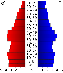
As of the census[15] of 2000, there were 57,813 people, 23,175 households, and 15,805 families residing in the county. The population density was 55 people per square mile (21/km²). There were 26,047 housing units at an average density of 25 per square mile (10/km²). The racial makeup of the county was 88.65% White, 3.26% Black or African American, 2.11% Native American, 0.85% Asian, 0.49% Pacific Islander, 2.02% from other races, and 2.62% from two or more races. 4.13% of the population were Hispanic or Latino of any race.
There were 23,175 households out of which 31.40% had children under the age of 18 living with them, 54.20% were married couples living together, 10.50% had a female householder with no husband present, and 31.80% were non-families. 27.70% of all households were made up of individuals and 12.10% had someone living alone who was 65 years of age or older. The average household size was 2.42 and the average family size was 2.95.
In the county, the population was spread out with 25.00% under the age of 18, 9.10% from 18 to 24, 27.30% from 25 to 44, 22.50% from 45 to 64, and 16.00% who were 65 years of age or older. The median age was 38 years. For every 100 females there were 93.70 males. For every 100 females age 18 and over, there were 90.40 males.
The median income for a household in the county was $33,006, and the median income for a family was $39,872. Males had a median income of $29,921 versus $20,791 for females. The per capita income for the county was $17,457. About 10.50% of families and 13.90% of the population were below the poverty line, including 19.70% of those under age 18 and 10.40% of those age 65 or over.
Politics
| Voter Registration and Party Enrollment as of January 15, 2018[16] | |||||
|---|---|---|---|---|---|
| Party | Number of Voters | Percentage | |||
| Democratic | 7,112 | 24.67% | |||
| Republican | 17,576 | 60.98% | |||
| Others | 4,135 | 14.35% | |||
| Total | 28,823 | 100% | |||
| Year | Republican | Democratic | Third parties |
|---|---|---|---|
| 2016 | 73.7% 16,009 | 20.3% 4,397 | 6.0% 1,304 |
| 2012 | 76.2% 15,177 | 23.8% 4,733 | |
| 2008 | 75.5% 17,067 | 24.5% 5,545 | |
| 2004 | 76.0% 17,685 | 24.0% 5,586 | |
| 2000 | 68.7% 14,902 | 30.2% 6,543 | 1.1% 238 |
| 1996 | 53.6% 11,712 | 34.4% 7,504 | 12.0% 2,625 |
| 1992 | 51.4% 13,095 | 26.4% 6,720 | 22.3% 5,670 |
| 1988 | 64.8% 15,248 | 34.3% 8,067 | 1.0% 223 |
| 1984 | 76.9% 19,642 | 22.4% 5,730 | 0.6% 162 |
| 1980 | 72.5% 17,989 | 23.0% 5,718 | 4.5% 1,121 |
| 1976 | 60.5% 14,202 | 38.2% 8,969 | 1.3% 303 |
| 1972 | 79.1% 19,348 | 18.6% 4,557 | 2.3% 564 |
| 1968 | 62.0% 14,370 | 25.0% 5,802 | 13.0% 3,011 |
| 1964 | 54.7% 12,297 | 45.3% 10,175 | |
| 1960 | 69.3% 14,860 | 30.7% 6,582 | |
| 1956 | 69.4% 15,348 | 30.6% 6,769 | |
| 1952 | 71.4% 17,589 | 28.6% 7,047 | |
| 1948 | 55.8% 10,352 | 44.3% 8,217 | |
| 1944 | 58.5% 11,211 | 41.1% 7,879 | 0.3% 65 |
| 1940 | 52.6% 10,792 | 46.6% 9,544 | 0.8% 166 |
| 1936 | 39.8% 7,457 | 59.5% 11,142 | 0.7% 124 |
| 1932 | 38.8% 6,837 | 61.2% 10,773 | |
| 1928 | 77.8% 12,748 | 21.4% 3,503 | 0.9% 141 |
| 1924 | 56.3% 7,524 | 28.4% 3,791 | 15.4% 2,054 |
| 1920 | 60.9% 6,611 | 33.8% 3,671 | 5.3% 576 |
| 1916 | 48.4% 2,854 | 39.8% 2,347 | 11.8% 694 |
| 1912 | 50.7% 2,900 | 41.1% 2,353 | 8.2% 466 |
Economy
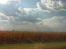
Primary industries in Garfield County are agriculture and livestock. Historically, crops have included wheat, corn, oats, sorghum, Kaffir corn, and alfalfa.[8] In addition, oil and gas and flour milling have proved fruitful for the county. The county seat of Enid, Oklahoma has the most grain storage capacity in the United States and one of the largest grain elevators in the world. Vance Air Force Base is also a major employer in the area of both soldiers and civilians.
Communities
Cities
Towns
Census-designated place
Other unincorporated places
NRHP sites
The following sites in Garfield County are listed on the National Register of Historic Places:
- Covington
- Kimmell Barn
- R. E. Hoy No. 1 Oil Well
- Enid
|
- Hunter
- Bank of Hunter
References
- 1 2 "State & County QuickFacts". United States Census Bureau. Archived from the original on July 10, 2011. Retrieved November 9, 2013.
- ↑ "Find a County". National Association of Counties. Archived from the original on 2011-05-31. Retrieved 2011-06-07.
- ↑ Gannett, Henry (1905). The Origin of Certain Place Names in the United States. Govt. Print. Off. p. 134.
- ↑ "Revised Delineations of Metropolitan Statistical Areas, Micropolitan Statistical Areas, and Combined Statistical Areas, and Guidance on Uses of the Delineations of These Areas" (PDF). Office of Management and Budget. July 15, 2015. Archived from the original (PDF) on November 10, 2016. Retrieved June 4, 2016.
- ↑ Turner, Alvin O. Cherokee Outlet Opening, Encyclopedia of Oklahoma History and Culture, Oklahoma Historical Society, 2009. Accessed April 4, 2015.
- ↑ Fulbright, Jim, Hell on Rails: Oklahoma Towns at War with the Rock Island Railroad, Wild West Magazine, December 2007
- ↑ Dortch, Steven D. The Chisholm Trail, Encyclopedia of Oklahoma History and Culture, Oklahoma Historical Society, 2009, Accessed April 4, 2015.
- 1 2 3 Wilson, Linda D. Garfield County, Encyclopedia of Oklahoma History and Culture, Oklahoma Historical Society, 2009. Accessed April 4, 2015.
- ↑ "2010 Census Gazetteer Files". United States Census Bureau. August 22, 2012. Retrieved February 21, 2015.
- ↑ "Population and Housing Unit Estimates". Retrieved June 9, 2017.
- ↑ "U.S. Decennial Census". United States Census Bureau. Archived from the original on May 12, 2015. Retrieved February 21, 2015.
- ↑ "Historical Census Browser". University of Virginia Library. Retrieved February 21, 2015.
- ↑ Forstall, Richard L., ed. (March 27, 1995). "Population of Counties by Decennial Census: 1900 to 1990". United States Census Bureau. Retrieved February 21, 2015.
- ↑ "Census 2000 PHC-T-4. Ranking Tables for Counties: 1990 and 2000" (PDF). United States Census Bureau. April 2, 2001. Retrieved February 21, 2015.
- ↑ "American FactFinder". United States Census Bureau. Archived from the original on 2013-09-11. Retrieved 2008-01-31.
- ↑ https://www.ok.gov/elections/documents/20180115%20-%20Registration%20By%20County%20%28vr2420%29.pdf
- ↑ Leip, David. "Dave Leip's Atlas of U.S. Presidential Elections". uselectionatlas.org. Retrieved 2018-03-29.
External links and further reading
- Encyclopedia of Oklahoma History and Culture - Garfield County
- Oklahoma Digital Maps: Digital Collections of Oklahoma and Indian Territory
- Rockwell, Stella, ed., Garfield County, Oklahoma, 1907-1982, Vol. I & II, Garfield Historical Society, Josten's Publishing Company, Topeka, Kansas. 1982.
Places adjacent to Garfield County, Oklahoma | ||||||||||
|---|---|---|---|---|---|---|---|---|---|---|
| ||||||||||
Municipalities and communities of Garfield County, Oklahoma, United States | ||
|---|---|---|
| Cities | | |
| Towns | ||
| CDP | ||
| Unincorporated communities | ||
