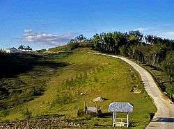
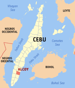
Alcoy, Cebu
Alcoy, officially the Municipality of Alcoy (Cebuano: Lungsod sa Alcoy; Tagalog: Bayan ng Alcoy), is a 5th class municipality in the province of Cebu, Philippines. According to the 2015 census, it has a population of 16,979 people.[4]
Alcoy | |
|---|---|
| Municipality of Alcoy | |
 Alcoy, Cebu | |
 Map of Cebu with Alcoy highlighted | |
OpenStreetMap 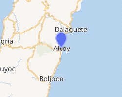
| |
.svg.png) Alcoy Location within the Philippines | |
| Coordinates: 9°42′29″N 123°30′22″E | |
| Country | |
| Region | Central Visayas (Region VII) |
| Province | Cebu |
| District | 2nd District of Cebu |
| Founded | 1880 [1] |
| Chartered | July 16, 1897 |
| Barangays | 8 (see Barangays) |
| Government | |
| • Type | Sangguniang Bayan |
| • Mayor | Michael Angelo D. Sestoso |
| • Vice Mayor | Jimmy M. Abajon |
| • Congressman | Wilfredo S. Caminero |
| • Electorate | 12,883 voters (2019) |
| Area | |
| • Total | 61.63 km2 (23.80 sq mi) |
| Elevation | 35.2 m (115.5 ft) |
| Population (2015 census)[4] | |
| • Total | 16,979 |
| • Density | 280/km2 (710/sq mi) |
| • Households | 3,383 |
| Economy | |
| • Income class | 5th municipal income class |
| • Poverty incidence | 32.74% (2015)[5] |
| • Revenue (₱) | 62,914,416.84 (2016) |
| Time zone | UTC+8 (PST) |
| ZIP code | 6023 |
| PSGC | |
| IDD : area code | +63 (0)32 |
| Climate type | tropical climate |
| Native languages | Cebuano Tagalog |
It is named after Alcoy in Spain.
Geography
Alcoy is 93 km (58 mi) South from Cebu City
It is bordered to the north by the town of Dalaguete, to the west is the town of Alegria, to the east is the Cebu Strait, and to the south is the town of Boljoon.
Barangays
Alcoy comprises 8 barangays:
| PSGC | Barangay | Population | ±% p.a. | |||
|---|---|---|---|---|---|---|
| 2015[4] | 2010[6] | |||||
| 072202001 | Atabay | 10.3% | 1,754 | 1,535 | 2.57% | |
| 072202002 | Daan-Lungsod | 11.0% | 1,863 | 1,569 | 3.32% | |
| 072202003 | Guiwang | 9.2% | 1,564 | 1,490 | 0.93% | |
| 072202004 | Nug‑as | 19.4% | 3,289 | 2,923 | 2.27% | |
| 072202005 | Pasol | 10.5% | 1,789 | 1,740 | 0.53% | |
| 072202006 | Poblacion | 21.3% | 3,610 | 2,991 | 3.65% | |
| 072202007 | Pugalo | 15.3% | 2,606 | 2,043 | 4.74% | |
| 072202008 | San Agustin | 3.0% | 504 | 466 | 1.50% | |
| Total | 16,979 | 14,757 | 2.71% | |||
Daan-Lungsod and Guiwang
Daan-Lungsod, formerly known as Mambahi, is the southernmost barangay of Alcoy. Tingko Beach is located partly in this small barangay and partly in Guiwang. A fiesta is held in Daan-Lungsod every 3 May in honor of Santa Cruz. There is a reef called Mabad-on which appears during low tide, and is completely submerged during high tide. Mabad-on is listed as Mambahi Reef in the Philippine maritime and navigation map.
The elementary school is located in Guiwang. Guiwang celebrates 13 June the feast day of Saint Anthony of Padua.
Two baluwarti (watchtowers) still stand in the two barangays. The watchtowers are the oldest-surviving structures in Alcoy and they are reminders of the Spanish occupation of Cebu Island. They were used to warn the locals that pirates were coming. Originally a settlement of Dalaguete, it was founded by the Spaniards in 1880 and was developed into a stop-over station for priests going to Dalaguete. In 1897, via a royal decree, Mambahi became a municipality and was renamed to Alcoy, after a city in Spain.[7]
Poblacion
The Poblacion is the principal barangay of Alcoy. It is where the main facilities of the town are located: the municipal government center, police station, and main health center.
Pugalo
The country's largest dolomite quarry is mined in Pugalo.
Climate
| Climate data for Alcoy, Cebu | |||||||||||||
|---|---|---|---|---|---|---|---|---|---|---|---|---|---|
| Month | Jan | Feb | Mar | Apr | May | Jun | Jul | Aug | Sep | Oct | Nov | Dec | Year |
| Average high °C (°F) | 29 (84) |
29 (84) |
30 (86) |
32 (90) |
31 (88) |
30 (86) |
30 (86) |
30 (86) |
30 (86) |
29 (84) |
29 (84) |
29 (84) |
30 (86) |
| Average low °C (°F) | 23 (73) |
23 (73) |
23 (73) |
24 (75) |
25 (77) |
25 (77) |
24 (75) |
24 (75) |
24 (75) |
24 (75) |
24 (75) |
23 (73) |
24 (75) |
| Average precipitation mm (inches) | 35 (1.4) |
28 (1.1) |
38 (1.5) |
51 (2.0) |
125 (4.9) |
195 (7.7) |
194 (7.6) |
173 (6.8) |
180 (7.1) |
192 (7.6) |
121 (4.8) |
64 (2.5) |
1,396 (55) |
| Average rainy days | 9.2 | 8.2 | 9.9 | 11.3 | 22.5 | 27.3 | 28.0 | 27.2 | 27.1 | 26.9 | 19.7 | 12.7 | 230 |
| Source: Meteoblue (Use with caution: this is modeled/calculated data, not measured locally.)[8] | |||||||||||||
Demographics
| Population census of Alcoy | |||||||||||||||||||||||||||||||||||||||||||||||||
|---|---|---|---|---|---|---|---|---|---|---|---|---|---|---|---|---|---|---|---|---|---|---|---|---|---|---|---|---|---|---|---|---|---|---|---|---|---|---|---|---|---|---|---|---|---|---|---|---|---|
|
| ||||||||||||||||||||||||||||||||||||||||||||||||
| Source: Philippine Statistics Authority[4][6][9] | |||||||||||||||||||||||||||||||||||||||||||||||||
Economy
Alcoy is mainly an agricultural town with Nug‑as, a mountain barangay, more than half of commercial crops. The rest of the communities rely on subsistence fishing and backyard farming. The country's largest dolomite quarry is mined in Pugalo. Beaches are located in Guiwang and Daanlungsod.
References
- https://m.facebook.com/story.php?story_fbid=1788450511243160&id=709399025814986
- "Municipality". Quezon City, Philippines: Department of the Interior and Local Government. Retrieved 31 May 2013.
- "Province: Cebu". PSGC Interactive. Quezon City, Philippines: Philippine Statistics Authority. Retrieved 12 November 2016.
- Census of Population (2015). "Region VII (Central Visayas)". Total Population by Province, City, Municipality and Barangay. PSA. Retrieved 20 June 2016.
- "PSA releases the 2015 Municipal and City Level Poverty Estimates". Quezon City, Philippines. Retrieved 12 October 2019.
- Census of Population and Housing (2010). "Region VII (Central Visayas)". Total Population by Province, City, Municipality and Barangay. NSO. Retrieved 29 June 2016.
- https://www.beyondcebu.com/alcoy/
- "Alcoy: Average Temperatures and Rainfall". Meteoblue. Retrieved 9 May 2020.
- Censuses of Population (1903–2007). "Region VII (Central Visayas)". Table 1. Population Enumerated in Various Censuses by Province/Highly Urbanized City: 1903 to 2007. NSO.
External links
![]()
Cebu City (capital) | |
| Municipalities |
|
| Component cities | |
| Highly urbanized cities | (Administratively independent from the province but grouped under Cebu by the Philippine Statistics Authority. However, qualified voters in Mandaue are allowed to vote in elections for Cebu provincial officials by virtue of Republic Act No. 6641, in accordance with Section 452-c of the Local Government Code of 1991.) |
| Authority control |
|
|---|