Santa Fe, Cebu
Santa Fe, officially the Municipality of Santa Fe, (Cebuano: Lungsod sa Santa Fe; Tagalog: Bayan ng Santa Fe), is a 4th class municipality in the province of Cebu, Philippines. According to the 2015 census, it has a population of 28,603 people.[3]
Santa Fe | |
|---|---|
| Municipality of Santa Fe | |
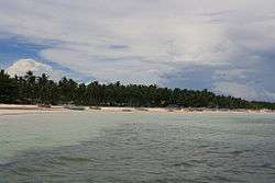 Og-tong beach area in Pooc with Mayet and Yooneek resorts | |
 Seal | |
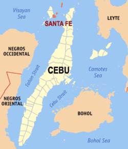 Map of Cebu with Santa Fe highlighted | |
| |
.svg.png) Santa Fe Location within the Philippines | |
| Coordinates: 11°09′N 123°48′E | |
| Country | |
| Region | Central Visayas (Region VII) |
| Province | Cebu |
| District | 4th District of Cebu |
| Barangays | 10 (see Barangays) |
| Government | |
| • Type | Sangguniang Bayan |
| • Mayor | Ithamar P. Espinosa |
| • Vice Mayor | Naomi I. Espinosa |
| • Congresswoman | Janice Z. Salimbangon |
| • Electorate | 19,213 voters (2019) |
| Area | |
| • Total | 28.05 km2 (10.83 sq mi) |
| Elevation | 7.3 m (24.0 ft) |
| Population (2015 census)[3] | |
| • Total | 28,603 |
| • Density | 1,000/km2 (2,600/sq mi) |
| • Households | 6,719 |
| Economy | |
| • Income class | 4th municipal income class |
| • Poverty incidence | 33.33% (2015)[4] |
| • Revenue (₱) | 77,746,630.49 (2016) |
| Time zone | UTC+8 (PST) |
| ZIP code | 6047 |
| PSGC | |
| IDD : area code | +63 (0)32 |
| Climate type | tropical climate |
| Native languages | Cebuano Filipino Waray |
The municipality's territory occupies the southeastern portion of Bantayan Island (marching with the municipality of Bantayan), together with the islands of Guintacan (or Kinatarkan), Hilantagaan and Hilantagaan Diot. Because the island's airport and principal ferry port are both located within the municipality, Santa Fe is considered the gateway to Bantayan and its islands.
Geography
Santa Fe is bordered to the north by the town of Bantayan, to the west also by Bantayan, to the east is the town of Medellin and to the south is the Tañon Strait
Barangays
Santa Fe comprises 10 barangays:
|
|||||||||||||||||||||||||||||||||||||||||||||||||||||||||||||||||||||||||||||||||||||||||||

Climate
| Climate data for Santa Fe, Cebu | |||||||||||||
|---|---|---|---|---|---|---|---|---|---|---|---|---|---|
| Month | Jan | Feb | Mar | Apr | May | Jun | Jul | Aug | Sep | Oct | Nov | Dec | Year |
| Average high °C (°F) | 28 (82) |
29 (84) |
30 (86) |
31 (88) |
31 (88) |
30 (86) |
30 (86) |
30 (86) |
30 (86) |
29 (84) |
29 (84) |
28 (82) |
30 (85) |
| Average low °C (°F) | 23 (73) |
23 (73) |
23 (73) |
24 (75) |
25 (77) |
25 (77) |
25 (77) |
25 (77) |
25 (77) |
25 (77) |
24 (75) |
23 (73) |
24 (75) |
| Average precipitation mm (inches) | 70 (2.8) |
49 (1.9) |
62 (2.4) |
78 (3.1) |
138 (5.4) |
201 (7.9) |
192 (7.6) |
185 (7.3) |
192 (7.6) |
205 (8.1) |
156 (6.1) |
111 (4.4) |
1,639 (64.6) |
| Average rainy days | 13.4 | 10.6 | 13.1 | 14.5 | 24.2 | 27.9 | 28.4 | 27.7 | 27.1 | 27.4 | 22.5 | 15.9 | 252.7 |
| Source: Meteoblue [6] | |||||||||||||
Demographics
| Population census of Santa Fe | |||||||||||||||||||||||||||||||||||||||||||||||||
|---|---|---|---|---|---|---|---|---|---|---|---|---|---|---|---|---|---|---|---|---|---|---|---|---|---|---|---|---|---|---|---|---|---|---|---|---|---|---|---|---|---|---|---|---|---|---|---|---|---|
|
| ||||||||||||||||||||||||||||||||||||||||||||||||
| Source: Philippine Statistics Authority[3][5][7][8] | |||||||||||||||||||||||||||||||||||||||||||||||||
Economy
Although there is some small-scale industry, the municipality's principal source of income is fishing and agriculture, and from holidaymakers who come in large numbers, most notably during Holy Week, to enjoy the particularly fine white sand and uncrowded beaches.
Transport
Bantayan Airport, serving the whole Bantayan Island, is located in Santa Fe. Air Juan operates scheduled flights between Mactan Airport three days a week. The town can also be reached by ferry from Hagnaya Wharf in San Remigio, Cebu.
Gallery
 Boat beached in Santa Fe
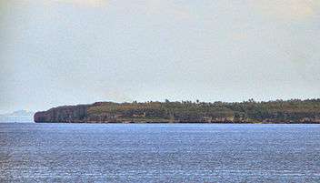 Guintacan Island; the 3 barangays of Hagdan, Kinatarkan and Langub are located on this island.
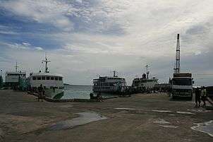 Ferry pier, Santa Fe
References
- "Municipality". Quezon City, Philippines: Department of the Interior and Local Government. Retrieved 31 May 2013.
- "Province: Cebu". PSGC Interactive. Quezon City, Philippines: Philippine Statistics Authority. Retrieved 12 November 2016.
- Census of Population (2015). "Region VII (Central Visayas)". Total Population by Province, City, Municipality and Barangay. PSA. Retrieved 20 June 2016.
- "PSA releases the 2015 Municipal and City Level Poverty Estimates". Quezon City, Philippines. Retrieved 12 October 2019.
- Census of Population and Housing (2010). "Region VII (Central Visayas)". Total Population by Province, City, Municipality and Barangay. NSO. Retrieved 29 June 2016.
- "Santa Fe: Average Temperatures and Rainfall". Meteoblue. Retrieved 10 May 2020.
- Censuses of Population (1903–2007). "Region VII (Central Visayas)". Table 1. Population Enumerated in Various Censuses by Province/Highly Urbanized City: 1903 to 2007. NSO.
- "Province of Cebu". Municipality Population Data. Local Water Utilities Administration Research Division. Retrieved 17 December 2016.
External links

- Santa Fe Profile at PhilAtlas.com
Places adjacent to Santa Fe, Cebu | ||||||||||
|---|---|---|---|---|---|---|---|---|---|---|
| ||||||||||
Cebu City (capital) | |
| Municipalities |
|
| Component cities | |
| Highly urbanized cities | (Administratively independent from the province but grouped under Cebu by the Philippine Statistics Authority. However, qualified voters in Mandaue are allowed to vote in elections for Cebu provincial officials by virtue of Republic Act No. 6641, in accordance with Section 452-c of the Local Government Code of 1991.) |
| Authority control |
|
|---|