Loay, Bohol
Loay, officially the Municipality of Loay, (Cebuano: Lungsod sa Loay; Tagalog: Bayan ng Loay), is a 5th class municipality in the province of Bohol, Philippines. According to the 2015 census, it has a population of 16,691 people.[4]
Loay | |
|---|---|
| Municipality of Loay | |
 View of Loboc River at Loay harbour | |
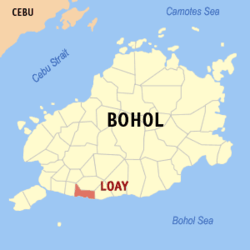 Map of Bohol with Loay highlighted | |
OpenStreetMap 
| |
.svg.png) Loay Location within the Philippines | |
| Coordinates: 9°36′N 124°01′E | |
| Country | |
| Region | Central Visayas (Region VII) |
| Province | Bohol |
| District | 3rd District |
| Founded | 1740 |
| Barangays | 24 (see Barangays) |
| Government | |
| • Type | Sangguniang Bayan |
| • Mayor | Hilario L. Ayuban |
| • Vice Mayor | Rodrigo B. Cubarol Jr. |
| • Congressman | Kristine Alexie B. Tutor |
| • Electorate | 13,073 voters (2019) |
| Area | |
| • Total | 48.24 km2 (18.63 sq mi) |
| Elevation | 4.8 m (15.7 ft) |
| Population (2015 census)[4] | |
| • Total | 16,691 |
| • Density | 350/km2 (900/sq mi) |
| • Households | 3,562 |
| Economy | |
| • Income class | 5th municipal income class |
| • Poverty incidence | 19.8% (2015)[5] |
| • Revenue (₱) | 63,756,029.07 (2016) |
| Time zone | UTC+8 (PST) |
| ZIP code | 6303 |
| PSGC | |
| IDD : area code | +63 (0)38 |
| Climate type | tropical monsoon climate |
| Native languages | Boholano dialect Cebuano Tagalog |
Located at the mouth of the Loboc River, the municipality can be divided into a lower and an upper part. The lower part used to be called Canipa‑an because of the presence of nipa swamps in this part of the town, while the upper part is named Ibabao, being located on a plateau.[6]
Recent historical research found that instead of being in Bool, Tagbilaran, the actual site of the Blood Compact between Legazpi and Sikatuna may be in barangay Hinawanan.[7] Loay is also known for the many antiques discovered in its soils, thus indicating a civilization before the Spanish came to Bohol: it has become an haven for the treasure hunters.
The town of Loay, Bohol celebrates its feast on May (date is movable), to honor the town patron Santisima Trinidad/Blessed Trinity[8]
History
During the period 1751–1754, Loay was a small village called Santissima Trinidad located at the strip of the Loboc River, as mentioned in the accounts of Father Juan Delgado (1892).
As a visita, it formerly belonged to the Municipality of Loboc. It was separated from the Loboc mission in 1795, although some state 1815 as the foundation date, and Redondo 1886 reflects that it became an independent parish in 1799.
Barangays
Loay comprises 24 barangays:
| PSGC | Barangay | Population | ±% p.a. | |||
|---|---|---|---|---|---|---|
| 2015[4] | 2010[9] | |||||
| 071228001 | Agape | 3.8% | 641 | 551 | 2.92% | |
| 071228002 | Alegria Norte | 1.8% | 300 | 299 | 0.06% | |
| 071228003 | Alegria Sur | 6.0% | 997 | 961 | 0.70% | |
| 071228004 | Bonbon | 1.7% | 282 | 314 | −2.03% | |
| 071228005 | Botoc Occidental | 3.7% | 619 | 521 | 3.34% | |
| 071228006 | Botoc Oriental | 3.9% | 644 | 648 | −0.12% | |
| 071228007 | Calvario | 5.0% | 828 | 715 | 2.83% | |
| 071228008 | Concepcion | 4.1% | 691 | 732 | −1.09% | |
| 071228010 | Hinawanan | 2.5% | 414 | 364 | 2.48% | |
| 071228011 | Las Salinas Norte | 1.6% | 272 | 217 | 4.40% | |
| 071228012 | Las Salinas Sur | 4.6% | 774 | 749 | 0.63% | |
| 071228013 | Palo | 2.4% | 397 | 335 | 3.29% | |
| 071228014 | Poblacion Ibabao | 7.4% | 1,231 | 1,220 | 0.17% | |
| 071228015 | Poblacion Ubos | 4.2% | 700 | 775 | −1.92% | |
| 071228016 | Sagnap | 3.0% | 506 | 503 | 0.11% | |
| 071228017 | Tambangan | 4.7% | 778 | 763 | 0.37% | |
| 071228018 | Tangcasan Norte | 4.4% | 729 | 699 | 0.80% | |
| 071228019 | Tangcasan Sur | 5.1% | 846 | 896 | −1.09% | |
| 071228020 | Tayong Occidental | 3.1% | 511 | 451 | 2.41% | |
| 071228021 | Tayong Oriental | 5.8% | 963 | 1,011 | −0.92% | |
| 071228023 | Tocdog Dacu | 4.1% | 677 | 701 | −0.66% | |
| 071228024 | Tocdog Ilaya | 2.5% | 415 | 424 | −0.41% | |
| 071228025 | Villalimpia | 10.2% | 1,697 | 1,674 | 0.26% | |
| 071228026 | Yanangan | 4.7% | 779 | 738 | 1.03% | |
| Total | 16,691 | 16,261 | 0.50% | |||
Climate
| Climate data for Loay, Bohol | |||||||||||||
|---|---|---|---|---|---|---|---|---|---|---|---|---|---|
| Month | Jan | Feb | Mar | Apr | May | Jun | Jul | Aug | Sep | Oct | Nov | Dec | Year |
| Average high °C (°F) | 28 (82) |
29 (84) |
30 (86) |
31 (88) |
31 (88) |
30 (86) |
30 (86) |
30 (86) |
30 (86) |
29 (84) |
29 (84) |
29 (84) |
30 (85) |
| Average low °C (°F) | 23 (73) |
22 (72) |
23 (73) |
23 (73) |
24 (75) |
25 (77) |
24 (75) |
24 (75) |
24 (75) |
24 (75) |
23 (73) |
23 (73) |
24 (74) |
| Average precipitation mm (inches) | 102 (4.0) |
85 (3.3) |
91 (3.6) |
75 (3.0) |
110 (4.3) |
141 (5.6) |
121 (4.8) |
107 (4.2) |
111 (4.4) |
144 (5.7) |
169 (6.7) |
139 (5.5) |
1,395 (55.1) |
| Average rainy days | 18.6 | 14.8 | 16.5 | 16.7 | 23.9 | 26.4 | 25.6 | 24.1 | 24.4 | 26.3 | 23.7 | 20.5 | 261.5 |
| Source: Meteoblue [10] | |||||||||||||
Demographics
| Population census of Loay | ||
|---|---|---|
| Year | Pop. | ±% p.a. |
| 1903 | 8,941 | — |
| 1918 | 10,513 | +1.09% |
| 1939 | 11,093 | +0.26% |
| 1948 | 10,694 | −0.41% |
| 1960 | 10,137 | −0.44% |
| 1970 | 10,634 | +0.48% |
| 1975 | 11,256 | +1.15% |
| 1980 | 10,842 | −0.75% |
| 1990 | 12,677 | +1.58% |
| 1995 | 12,450 | −0.34% |
| 2000 | 14,433 | +3.22% |
| 2007 | 15,881 | +1.33% |
| 2010 | 16,261 | +0.86% |
| 2015 | 16,691 | +0.50% |
| Source: Philippine Statistics Authority[4][9][11][12] | ||
Tourism
Loay is one of the locations to take a Loboc river lunch cruise.
The church and belfry of Loay were severely damaged by the 2013 earthquake.
 Lunch cruise on the Loboc river
 Loay church 2006
 Remains of Loay church post-2013 earthquake
 Remains of Loay church post-2013 earthquake
 Remains of Loay church post-2013 earthquake
References
- "Municipality". Quezon City, Philippines: Department of the Interior and Local Government. Retrieved 31 May 2013.
- "Province: Bohol". PSGC Interactive. Quezon City, Philippines: Philippine Statistics Authority. Retrieved 12 November 2016.
- "Loay, Bohol Profile". PhilAtlas.com. Retrieved 15 June 2020.
- Census of Population (2015). "Region VII (Central Visayas)". Total Population by Province, City, Municipality and Barangay. PSA. Retrieved 20 June 2016.
- "PSA releases the 2015 Municipal and City Level Poverty Estimates". Quezon City, Philippines. Retrieved 12 October 2019.
- "Municipality of Loay". Province of Bohol. Retrieved 2012-09-19.
- Resolution No. 04, Series of 2005. National Historical Institute. 1 July 2005
- "Bohol Festivals Timetable". "www.bohol-philippines.com". Retrieved 2019-04-05.
- Census of Population and Housing (2010). "Region VII (Central Visayas)". Total Population by Province, City, Municipality and Barangay. NSO. Retrieved 29 June 2016.
- "Loay: Average Temperatures and Rainfall". Meteoblue. Retrieved 9 May 2020.
- Censuses of Population (1903–2007). "Region VII (Central Visayas)". Table 1. Population Enumerated in Various Censuses by Province/Highly Urbanized City: 1903 to 2007. NSO.
- "Province of Bohol". Municipality Population Data. Local Water Utilities Administration Research Division. Retrieved 17 December 2016.
Sources
- Delgado, Fr Juan José (1892). Historia sacro-profana, política y natural de las Islas del Poniente, llamadas Filipinas (in Spanish). Manila: Imprenta de "Eco de Filipinas" de D. Juan Atayde. OCLC 351181.CS1 maint: ref=harv (link)
- Sendino y Redondo, Felipe (1886). Breve reseña de lo que fue y de lo que es la Diócesis de Cebú en las Islas Filipinas (in Spanish). Manila: Colegio de Santo Tomas.
| Wikimedia Commons has media related to Loay. |
External links
Places adjacent to Loay, Bohol | ||||||||||
|---|---|---|---|---|---|---|---|---|---|---|
| ||||||||||