Getafe, Bohol
Getafe, officially the Municipality of Getafe (Cebuano: Lungsod sa Getafe; Tagalog: Bayan ng Getafe), is a 3rd class municipality in the province of Bohol, Philippines. According to the 2015 census, it has a population of 30,955 people.[4]
Getafe | |
|---|---|
| Municipality of Getafe | |
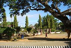 Poblacion of Getafe | |
 Seal | |
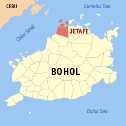 Map of Bohol with Getafe highlighted | |
OpenStreetMap 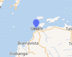
| |
.svg.png) Getafe Location within the Philippines | |
| Coordinates: 10°09′N 124°09′E | |
| Country | |
| Region | Central Visayas (Region VII) |
| Province | Bohol |
| District | 2nd District |
| Founded | 1874 |
| Barangays | 24 (see Barangays) |
| Government | |
| • Type | Sangguniang Bayan |
| • Mayor | Casey Shaun M. Camacho |
| • Vice Mayor | Eduardo A. Torremocha |
| • Congressman | Erico Aristotle C. Aumentado |
| • Electorate | 20,739 voters (2019) |
| Area | |
| • Total | 120.50 km2 (46.53 sq mi) |
| Elevation | 5.1 m (16.7 ft) |
| Population (2015 census)[4] | |
| • Total | 30,955 |
| • Density | 260/km2 (670/sq mi) |
| • Households | 7,218 |
| Economy | |
| • Income class | 3rd municipal income class |
| • Poverty incidence | 42.94% (2015)[5] |
| • Revenue (₱) | 90,971,295.81 (2016) |
| Time zone | UTC+8 (PST) |
| ZIP code | 6334 |
| PSGC | |
| IDD : area code | +63 (0)38 |
| Climate type | tropical monsoon climate |
| Native languages | Boholano dialect Cebuano Tagalog |
Also spelt Jetafe, Getafe and surrounding areas suffered moderate-to-severe damage to houses, churches, and other structures in the 2013 Bohol earthquake, which caused approximately 130 fatalities in total.[6]
Getafe also includes the islands of Jandayan (Handayan), Banacon, and the western part of Mahanay. The small islands of Nasingin and Pandanon are considered to be one of the most densely populated islands in the world. The Danajon Bank, the only double barrier reef in the Philippines passes through these islands.
The town of Getafe, Bohol celebrates its feast on the last Saturday of January, to honor the town patron Holy Infant.[7]
Barangays
Getafe comprises 24 barangays:
| PSGC | Barangay | Population | ±% p.a. | |||
|---|---|---|---|---|---|---|
| 2015[4] | 2010[8] | |||||
| 071226001 | Alumar | 3.8% | 1,164 | 935 | 4.26% | |
| 071226002 | Banacon | 4.2% | 1,298 | 1,304 | −0.09% | |
| 071226003 | Buyog | 2.9% | 906 | 775 | 3.02% | |
| 071226004 | Cabasakan | 3.8% | 1,179 | 1,149 | 0.49% | |
| 071226006 | Campao Occidental | 1.6% | 484 | 418 | 2.83% | |
| 071226007 | Campao Oriental | 3.3% | 1,034 | 963 | 1.36% | |
| 071226008 | Cangmundo | 3.1% | 972 | 968 | 0.08% | |
| 071226009 | Carlos P. Garcia | 3.2% | 994 | 858 | 2.84% | |
| 071226010 | Corte Baud | 2.8% | 868 | 704 | 4.07% | |
| 071226011 | Handumon | 3.8% | 1,172 | 983 | 3.41% | |
| 071226012 | Jagoliao | 4.4% | 1,353 | 1,478 | −1.67% | |
| 071226013 | Jandayan Norte | 3.1% | 963 | 901 | 1.28% | |
| 071226014 | Jandayan Sur | 5.0% | 1,538 | 1,360 | 2.37% | |
| 071226015 | Mahanay (Mahanay Island) | 1.7% | 538 | 484 | 2.03% | |
| 071226016 | Nasingin | 6.6% | 2,045 | 1,809 | 2.36% | |
| 071226017 | Pandanon | 7.2% | 2,228 | 1,840 | 3.71% | |
| 071226018 | Poblacion | 8.7% | 2,695 | 2,371 | 2.47% | |
| 071226019 | Saguise | 5.3% | 1,652 | 1,358 | 3.80% | |
| 071226020 | Salog | 3.9% | 1,195 | 1,036 | 2.76% | |
| 071226021 | San Jose | 5.6% | 1,729 | 1,432 | 3.65% | |
| 071226022 | Santo Niño | 2.5% | 768 | 686 | 2.17% | |
| 071226023 | Taytay | 5.0% | 1,536 | 1,334 | 2.72% | |
| 071226024 | Tugas | 2.9% | 886 | 896 | −0.21% | |
| 071226025 | Tulang | 5.7% | 1,758 | 1,746 | 0.13% | |
| Total | 30,955 | 27,788 | 2.08% | |||
Climate
| Climate data for Getafe, Bohol | |||||||||||||
|---|---|---|---|---|---|---|---|---|---|---|---|---|---|
| Month | Jan | Feb | Mar | Apr | May | Jun | Jul | Aug | Sep | Oct | Nov | Dec | Year |
| Average high °C (°F) | 28 (82) |
28 (82) |
29 (84) |
31 (88) |
31 (88) |
30 (86) |
30 (86) |
30 (86) |
30 (86) |
29 (84) |
29 (84) |
28 (82) |
29 (85) |
| Average low °C (°F) | 23 (73) |
23 (73) |
23 (73) |
23 (73) |
24 (75) |
24 (75) |
24 (75) |
24 (75) |
24 (75) |
24 (75) |
24 (75) |
23 (73) |
24 (74) |
| Average precipitation mm (inches) | 98 (3.9) |
82 (3.2) |
96 (3.8) |
71 (2.8) |
104 (4.1) |
129 (5.1) |
101 (4.0) |
94 (3.7) |
99 (3.9) |
135 (5.3) |
174 (6.9) |
143 (5.6) |
1,326 (52.3) |
| Average rainy days | 18.0 | 14.1 | 17.1 | 16.8 | 23.7 | 25.7 | 25.8 | 23.3 | 24.2 | 25.9 | 24.0 | 20.6 | 259.2 |
| Source: Meteoblue [9] | |||||||||||||
Demographics
| Population census of Getafe | ||
|---|---|---|
| Year | Pop. | ±% p.a. |
| 1903 | 10,447 | — |
| 1918 | 13,355 | +1.65% |
| 1939 | 16,670 | +1.06% |
| 1948 | 18,597 | +1.22% |
| 1960 | 19,715 | +0.49% |
| 1970 | 20,144 | +0.22% |
| 1975 | 23,563 | +3.19% |
| 1980 | 24,376 | +0.68% |
| 1990 | 21,135 | −1.42% |
| 1995 | 23,927 | +2.35% |
| 2000 | 26,826 | +2.48% |
| 2007 | 27,852 | +0.52% |
| 2010 | 27,788 | −0.08% |
| 2015 | 30,955 | +2.08% |
| Source: Philippine Statistics Authority[4][8][10][11] | ||
Education
-
- Campao Oriental National High School
- Handumon National High School
- Pandanon National High School
- Santo Niño Institute
- Tulang National High School
-
- Alumar Elementary School
- Banacon Elementary School
- Cabasakan Elementary School
- Campao Elementary School
- Cangmundo Elementary School
- Corte Baud Elementary School
- Getafe Central Elementary School
- Handumon Elementary School
- Jagoliao Elementary School
- Jandayan Elementary School
- Mahanay Elementary School
- Nasingin Elementary School
- Pandanon Elementary School
- Saguise Elementary School
- Salog Elementary School
- San Jose Elementary School
- Taytay Elementary School
- Tugas Elementary School
- Tulang Elementary School
-
- Advent Care Multi-Grade School
- Galbreath International School
References
- "Municipality". Quezon City, Philippines: Department of the Interior and Local Government. Retrieved 31 May 2013.
- "Province: Bohol". PSGC Interactive. Quezon City, Philippines: Philippine Statistics Authority. Retrieved 12 November 2016.
- "Getafe, Bohol Profile". PhilAtlas.com. Retrieved 15 June 2020.
- Census of Population (2015). "Region VII (Central Visayas)". Total Population by Province, City, Municipality and Barangay. PSA. Retrieved 20 June 2016.
- "PSA releases the 2015 Municipal and City Level Poverty Estimates". Quezon City, Philippines. Retrieved 12 October 2019.
- "Archived copy". Archived from the original on 2013-10-17. Retrieved 2013-10-16.CS1 maint: archived copy as title (link)
- "Bohol Festivals Timetable". "www.bohol-philippines.com". Retrieved 2019-03-19.
- Census of Population and Housing (2010). "Region VII (Central Visayas)". Total Population by Province, City, Municipality and Barangay. NSO. Retrieved 29 June 2016.
- "Getafe: Average Temperatures and Rainfall". Meteoblue. Retrieved 9 May 2020.
- Censuses of Population (1903–2007). "Region VII (Central Visayas)". Table 1. Population Enumerated in Various Censuses by Province/Highly Urbanized City: 1903 to 2007. NSO.
- "Province of Bohol". Municipality Population Data. Local Water Utilities Administration Research Division. Retrieved 17 December 2016.
- "List of High Schools". DepEd - Bohol. January 1, 2015. Retrieved 5 March 2015.
- "Catholic Educational Institutions". Roman Catholic Diocese of Talibon. January 1, 2014. Archived from the original on February 4, 2015. Retrieved 5 March 2015.
- "List of Elementary Schools". DepEd - Bohol. January 1, 2015. Retrieved 5 March 2015.
- "List and Status of Private Schools" (PDF). DepEd - Region VII. January 22, 2015. Archived from the original (PDF) on 2 April 2015. Retrieved 5 March 2015.
External links
- Getafe Profile at PhilAtlas.com
- Philippine Standard Geographic Code
- Provincial Government of Bohol: Municipality of Getafe
Places adjacent to Getafe, Bohol | ||||||||||
|---|---|---|---|---|---|---|---|---|---|---|
| ||||||||||