San Remigio, Cebu
San Remigio, officially called the Municipality of San Remigio (Cebuano: Lungsod sa San Remigio; Tagalog: Bayan ng San Remigio), is a 3rd class municipality in the province of Cebu, Philippines. According to the 2015 census, it has a population of 57,557 people.[4]
San Remigio | |
|---|---|
| Municipality of San Remigio | |
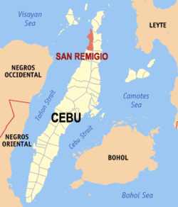 Map of Cebu with San Remigio highlighted | |
OpenStreetMap 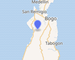
| |
.svg.png) San Remigio Location within the Philippines | |
| Coordinates: 11°00′N 123°57′E | |
| Country | |
| Region | Central Visayas (Region VII) |
| Province | Cebu |
| District | 4th district of Cebu |
| Founded | 1863 |
| Barangays | 27 (see Barangays) |
| Government | |
| • Type | Sangguniang Bayan |
| • Mayor | Mariano R. Martinez |
| • Vice Mayor | Alfonso C. Pestolante |
| • Congresswoman | Janice Z. Salimbangon |
| • Electorate | 41,006 voters (2019) |
| Area | |
| • Total | 95.27 km2 (36.78 sq mi) |
| Elevation | 11.3 m (37.1 ft) |
| Population (2015 census)[4] | |
| • Total | 57,557 |
| • Density | 600/km2 (1,600/sq mi) |
| • Households | 14,397 |
| Economy | |
| • Income class | 3rd municipal income class |
| • Poverty incidence | 23.64% (2015)[5] |
| • Revenue (₱) | 129,864,366.92 (2016) |
| Time zone | UTC+8 (PST) |
| ZIP code | 6011 |
| PSGC | |
| IDD : area code | +63 (0)32 |
| Climate type | tropical monsoon climate |
| Native languages | Cebuano Tagalog |
| Website | sanremigio |
San Remigio (local pronunciation: //san remiyo) is bordered to the north by Medellin, to the west is Tañon Strait then Bantayan Island, to the east is the City of Bogo and the town of Tabogon, and to the south is the town of Tabuelan.
San Remigio celebrates its annual fiesta on the 15th and 16 May in honor of their patron saints, San Isidro Labrador and San Juan Nepomuceno. The parish, which was founded in 1864, celebrated its 150th anniversary celebration in May 2014.
History
San Remigio was formerly known as "Kanghagas", a kind of tree that grew in abundance in the area. When the Spanish conquistadores arrived, they identified a town site by clearing the kanghagas trees. At the time, Kanghagas was part of barangay Punta.
Initially, the visita of Kanghagas was within the jurisdiction of Bantayan. In 1850, the town of Bogo established a parish and took over civil governance of the three barrios of Kanghagas, Lambusan, and Victoria (formerly Maarat). Later, barangay Kanghagas was renamed Isabel after the queen of Spain, but was eventually changed in 1863 to its new and permanent name, San Remigio. The name San Remigio can be found in Florence, Italy called Church of San Remigio, a church building that was built in the 1100s and later rebuilt in the 1300s.[6] In 1864, San Remigio and other barrios established their own parish, San Juan Nepomuceno Parish (Redondo 1886, p. 165).
Barangays
San Remigio comprises 27 barangays:
| PSGC | Barangay | Population | ±% p.a. | |||
|---|---|---|---|---|---|---|
| 2015[4] | 2010[7] | |||||
| 072243001 | Anapog | 3.4% | 1,951 | 1,816 | 1.37% | |
| 072243002 | Argawanon | 7.2% | 4,118 | 3,996 | 0.57% | |
| 072243003 | Bagtic | 1.9% | 1,078 | 934 | 2.77% | |
| 072243004 | Bancasan | 2.9% | 1,644 | 1,423 | 2.79% | |
| 072243005 | Batad | 2.6% | 1,488 | 1,377 | 1.49% | |
| 072243006 | Busogon | 2.8% | 1,592 | 1,445 | 1.86% | |
| 072243007 | Calambua | 2.5% | 1,450 | 1,350 | 1.37% | |
| 072243008 | Canagahan | 2.6% | 1,489 | 1,377 | 1.50% | |
| 072243009 | Dapdap | 3.2% | 1,825 | 1,415 | 4.96% | |
| 072243010 | Gawaygaway | 2.5% | 1,423 | 1,426 | −0.04% | |
| 072243011 | Hagnaya | 7.2% | 4,127 | 3,527 | 3.04% | |
| 072243012 | Kayam | 2.3% | 1,350 | 1,307 | 0.62% | |
| 072243013 | Kinawahan | 1.5% | 869 | 896 | −0.58% | |
| 072243014 | Lambusan | 4.3% | 2,495 | 2,158 | 2.80% | |
| 072243015 | Lawis | 2.2% | 1,251 | 1,079 | 2.86% | |
| 072243016 | Libaong | 2.1% | 1,213 | 1,132 | 1.32% | |
| 072243017 | Looc | 3.8% | 2,201 | 2,021 | 1.64% | |
| 072243018 | Luyang | 4.1% | 2,343 | 2,152 | 1.63% | |
| 072243019 | Mano | 6.4% | 3,698 | 3,179 | 2.92% | |
| 072243020 | Poblacion | 9.3% | 5,356 | 4,309 | 4.23% | |
| 072243021 | Punta | 5.5% | 3,174 | 2,659 | 3.43% | |
| 072243022 | Sab‑a | 1.8% | 1,045 | 1,169 | −2.11% | |
| 072243023 | San Miguel | 3.0% | 1,706 | 1,568 | 1.62% | |
| 072243024 | Tacup | 4.1% | 2,354 | 2,269 | 0.70% | |
| 072243025 | Tambongon | 5.4% | 3,100 | 2,727 | 2.47% | |
| 072243026 | To‑ong | 2.3% | 1,307 | 1,163 | 2.25% | |
| 072243027 | Victoria | 3.3% | 1,910 | 1,520 | 4.44% | |
| Total | 57,557 | 51,394 | 2.18% | |||
Climate
| Climate data for San Remegio, Cebu | |||||||||||||
|---|---|---|---|---|---|---|---|---|---|---|---|---|---|
| Month | Jan | Feb | Mar | Apr | May | Jun | Jul | Aug | Sep | Oct | Nov | Dec | Year |
| Average high °C (°F) | 28 (82) |
29 (84) |
29 (84) |
30 (86) |
30 (86) |
30 (86) |
29 (84) |
29 (84) |
29 (84) |
29 (84) |
29 (84) |
29 (84) |
29 (84) |
| Average low °C (°F) | 22 (72) |
22 (72) |
22 (72) |
23 (73) |
25 (77) |
25 (77) |
25 (77) |
25 (77) |
25 (77) |
24 (75) |
24 (75) |
23 (73) |
24 (75) |
| Average precipitation mm (inches) | 78 (3.1) |
57 (2.2) |
84 (3.3) |
79 (3.1) |
118 (4.6) |
181 (7.1) |
178 (7.0) |
169 (6.7) |
172 (6.8) |
180 (7.1) |
174 (6.9) |
128 (5.0) |
1,598 (62.9) |
| Average rainy days | 16.7 | 13.8 | 17.3 | 18.5 | 23.2 | 26.5 | 27.1 | 26.0 | 26.4 | 27.5 | 24.6 | 21.0 | 268.6 |
| Source: Meteoblue [8] | |||||||||||||
Demographics
| Population census of San Remigio | ||
|---|---|---|
| Year | Pop. | ±% p.a. |
| 1903 | 9,813 | — |
| 1918 | 17,141 | +3.79% |
| 1939 | 21,232 | +1.02% |
| 1948 | 20,645 | −0.31% |
| 1960 | 24,113 | +1.30% |
| 1970 | 25,569 | +0.59% |
| 1975 | 26,689 | +0.86% |
| 1980 | 29,412 | +1.96% |
| 1990 | 36,124 | +2.08% |
| 1995 | 38,501 | +1.20% |
| 2000 | 44,028 | +2.92% |
| 2007 | 48,516 | +1.35% |
| 2010 | 51,394 | +2.12% |
| 2015 | 57,557 | +2.18% |
| Source: Philippine Statistics Authority[4][7][9][10] | ||
Tourism
San Remigio has the longest shoreline of any municipality in Cebu. There are several beach resorts, as well as public beaches with long stretches of white sand and warm ocean.
Today, San Remigio has become a swimming and diving destination. There are a few marine sanctuaries, with new dive sites being developed as we speak. A PADI dive shop in San Remigio Beach Club caters to beginner and experienced divers who want to enjoy San Remigio's marine life.
The port of Hagnaya offers a frequent ferry service to Santa Fe and Bantayan Island as well as Masbate (particularly Cawayan and Placer).
Beach Resorts in San Remigio include Casa Del Mar Beach Resort, Elegant Beach Resort, San Remigio Beach Club, and Hagnaya Beach Resort.
Schools
The town of San Remigio has many public and private elementary and secondary schools.
-
- Cebu Technoligical University - San Remigio Extension Campus
-
- Dapdap National High School
- Jose Martinez Memorial (Gawaygaway) National High School
- Lambusan National High School
- Libaong National High School
- Luyang National High School
- San Miguel National High School
- San Remigio National High School
-
- Argawanon
- Anapog
- Batad
- Busogon
- Calambua
- Kinawahan
- Tambongon
- Living Hope Baptist Christian School
- San Remigio Learning Center
Churches
There are many churches that hold services throughout the week and weekends.
- The Church of Jesus Christ of Latter Day Saints - Sunday service at 9 am
- San Juan Nepomuceno Catholic Church (daily mass)
- Bible Baptist Church
- Living Hope Baptist Church
- Iglesia Ni Cristo
- Seventh Day Adventist
- Northwest House of Hope Fellowship
- Cebu Madinah Mosque
- Al Hajja Safia Mosque
- Mano Baptist Church
- Punta Baptist Church
Notable Events
- Archaeological excavation in 2012 by archaeologist Jojo Bersales and his team. With permission from the archdiocese of Cebu and other authorities, his team conducted an excavation and unearthed a burial site that is believed to date back in the 1500s. Alongside human skeletons were carinated pots. These pots with flat designs and rounded base were a sign of the iron era. They were mainly intended for burial rituals and not for cooking as evidenced by their fragile design and quality. Each burial site with human remains had a carinated pot next to it. Back in the day, people believed that spirits travel through the ocean to their final resting place. These pots were filled with food for use on their travel. The archaeologists also noted that bodies were buried with their feet pointing to the ocean, affirming that ancient people believed that the final resting place was on the other side of the ocean. You can watch the excavation video at https://www.youtube.com/watch?v=XGYj-krJk-U
References
- "Municipality". Quezon City, Philippines: Department of the Interior and Local Government. Retrieved 31 May 2013.
- "Province: Cebu". PSGC Interactive. Quezon City, Philippines: Philippine Statistics Authority. Retrieved 12 November 2016.
- "San Remigio, Cebu Profile". PhilAtlas.com. Retrieved 15 June 2020.
- Census of Population (2015). "Region VII (Central Visayas)". Total Population by Province, City, Municipality and Barangay. PSA. Retrieved 20 June 2016.
- "PSA releases the 2015 Municipal and City Level Poverty Estimates". Quezon City, Philippines. Retrieved 12 October 2019.
- Cioni, Jacopo (2016-12-19). "Church of San Remigio FlorenceCity - Rivista Fiorentina". FlorenceCity - Rivista Fiorentina (in Italian). Retrieved 2019-02-27.
- Census of Population and Housing (2010). "Region VII (Central Visayas)". Total Population by Province, City, Municipality and Barangay. NSO. Retrieved 29 June 2016.
- "San Remegio: Average Temperatures and Rainfall". Meteoblue. Retrieved 10 May 2020.
- Censuses of Population (1903–2007). "Region VII (Central Visayas)". Table 1. Population Enumerated in Various Censuses by Province/Highly Urbanized City: 1903 to 2007. NSO.
- "Province of Cebu". Municipality Population Data. Local Water Utilities Administration Research Division. Retrieved 17 December 2016.
Sources
- Ereccion de Pueblos: 1818-1887. (This contains the Spanish and original texts of the Creation of Towns: photocopied from the National Archives)
- Sendino y Redondo, Felipe (1886). Breve reseña de lo que fue y de lo que es la Diócesis de Cebú en las Islas Filipinas (in Spanish). Manila: Colegio de Santo Tomas.
- Trota José, Regalado (2008). Curas de almas : a preliminary listing of parishes and parish priests in the 19th century Philippines based on the Guías de Forasteros, 1834-1898. UST Press. ISBN 978-9715064590.
External links
Places adjacent to San Remigio, Cebu | ||||||||||
|---|---|---|---|---|---|---|---|---|---|---|
| ||||||||||
Cebu City (capital) | |
| Municipalities |
|
| Component cities | |
| Highly urbanized cities | (Administratively independent from the province but grouped under Cebu by the Philippine Statistics Authority. However, qualified voters in Mandaue are allowed to vote in elections for Cebu provincial officials by virtue of Republic Act No. 6641, in accordance with Section 452-c of the Local Government Code of 1991.) |
| Authority control |
|
|---|