Ajodhyanagar
Ajodhyanagar is a census town within the jurisdiction of the Usthi police station in the Magrahat I CD block in the Diamond Harbour subdivision of the South 24 Parganas district in the Indian state of West Bengal.
Ajodhyanagar | |
|---|---|
Census Town | |
 Ajodhyanagar Location in West Bengal  Ajodhyanagar Location in India | |
| Coordinates: 22.3278°N 88.2714°E | |
| Country | |
| State | West Bengal |
| District | South 24 Parganas |
| CD block | Magrahat I |
| Area | |
| • Total | 1.03 km2 (0.40 sq mi) |
| Elevation | 8 m (26 ft) |
| Population (2011) | |
| • Total | 4,409 |
| • Density | 4,300/km2 (11,000/sq mi) |
| Languages | |
| • Official | Bengali[1][2] |
| • Additional official | English[1] |
| Time zone | UTC+5:30 (IST) |
| PIN | 743513 |
| Telephone code | +91 3174 |
| Vehicle registration | WB-19 to WB-22, WB-95 to WB-99 |
| Lok Sabha constituency | Mathurapur (SC) |
| Vidhan Sabha constituency | Magrahat Paschim |
| Website | www |
Geography
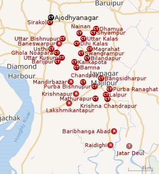 |
| Cities and towns in the eastern part of Diamond Harbour subdivision (including Magrahat I & II, Mandirbazar, Mathurapur I & II CD blocks) in South 24 Parganas district M: municipal city/ town, CT: census town, R: rural/ urban centre, N: neighbourhood, T: religious place Owing to space constraints in the small map, the actual locations in a larger map may vary slightly |
Area overview
Diamond Harbour subdivision is a rural subdivision with patches of urbanization. Only 14.61% of the population lives in the urban areas and an overwhelming 85.39% lives the rural areas. In the eastern portion of the subdivision {shown in the map alongside) there are 24 census towns. The entire district is situated in the Ganges Delta and the eastern part of the district is a flat plain area with small towns, many in clusters. Location of places in the larger map varies a little. It is an Open Street Map, while we are using coordinates as in Google maps.[3][4][5]
Note: The map alongside presents some of the notable locations in the subdivision. All places marked in the map are linked in the larger full screen map.
Location
Ajodhyanagar is located at 22.3278°N 88.2714°E
Hasimnagar, Baneshwarpur of the Falta CD block and Ajodhyanagar, Sirakol of the Magrahat I CD block form a cluster of census towns.[6]
Demographics
According to the 2011 Census of India, Ajodhyanagar had a total population of 4,409 of which 2,173 (49%) were males and 2,236 (51%) were females. There were 584 persons in the age range of 0-6 years. The total number of literate persons in Ajodhyanagar was 2,691 (70.35% of the population over 6 years).[7]
Infrastructure
According to the District Census Handbook 2011, Ajodhyanagar covered an area of 1.0252 km2. Among the civic amenities, the protected water supply involved overhead tank. It had 353 domestic electric connections. Among the medical facilities it had 3 hospitals, 4 dispensaries/ health centres and 6 medicine shops. Among the educational facilities it had were 1 primary school, 1 middle school, 1 secondary school, 1 senior secondary school.[8]
Transport
Ajodhyanagar is on the National Highway 12 / Diamond Harbour Road.[9]
References
- "Fact and Figures". Wb.gov.in. Retrieved 5 July 2019.
- "52nd REPORT OF THE COMMISSIONER FOR LINGUISTIC MINORITIES IN INDIA" (PDF). Nclm.nic.in. Ministry of Minority Affairs. p. 85. Archived from the original (PDF) on 25 May 2017. Retrieved 5 July 2019.
- "District Statistical Handbook 2014 South Twety-four Parganas". Table 2.1 , 2.2, 2.4b. Department of Statistics and Programme Implementation, Government of West Bengal. Archived from the original on 2019-01-21. Retrieved 5 December 2019.
- "Census of India 2011, West Bengal, District Census Handbook, South Twentyfour Parganas, Series – 20, Part XII-A, Village and Town Directory" (PDF). Page 13, Physigraphy. Directorate of Census Operations, West Bengal. Retrieved 5 December 2019.
- "District Human Development Report: South 24 Parganas". Chapter 9: Sundarbans and the Remote Islanders, p 290-311. Development & Planning Department, Government of West Bengal, 2009. Archived from the original on 5 October 2016. Retrieved 5 December 2019.
- "District Census Handbook: South 24 Parganas, Series 20, Part XII B" (PDF). Map of Falta CD block on page 471 and map of Magrahat I CD block on page 445. Directorate of Census Operations, West Bengal, 2011. Retrieved 23 November 2019.
- "CD block Wise Primary Census Abstract Data(PCA)". West Bengal – District-wise CD blocks. Registrar General and Census Commissioner, India. Retrieved 16 November 2019.
- "District Census Handbook South Twenty Four Parganas, Census of India 2011, Series 20, Part XII A" (PDF). Section II Town Directory, Pages 999-1006 Statement I: Status and Growth History, Pages 1006-1010; Statement II: Physical Aspects and Location of Towns, Pages 1010-1015; Statement III: Civic and other Amenities, Pages 1015-1019; Statement IV: Medical Facilities 2009, Pages 1019-1027 Statement V: Educational, Recreational and Cultural Facilities, Pages 1027- 1029: Statement VI:Industry and Banking. Directorate of Census Operations V, West Bengal. Retrieved 19 November 2018.
- Google maps