Jaynagar Majilpur
Jaynagar Majilpur, popularly known as Jaynagar, is a city and a municipality of the South 24 Parganas district in the Indian state of West Bengal. It is situated in the southern suburbs of Kolkata. As an urban setup in the vicinity of the Kolkata, the city is within the area of Greater Kolkata. It is a part of the area covered by the Kolkata Metropolitan Development Authority (KMDA).[3] Jaynagar and Majilpur are two separate towns. Since the formation of the municipality, these two towns are known together as Jaynagar Majilpur. The city is very famous for its confectionery called Jaynagarer Moa.[4]
Jaynagar Majilpur | |
|---|---|
City | |
 Jaynagar Majilpur Municipality | |
 Jaynagar Majilpur Location in West Bengal  Jaynagar Majilpur Location in India  Jaynagar Majilpur Location in Asia .svg.png) Jaynagar Majilpur Location in Earth | |
| Coordinates: 22.1772°N 88.4258°E | |
| Country | |
| State | West Bengal |
| Division | Presidency |
| District | South 24 Parganas |
| Region | Greater Kolkata |
| Government | |
| • Type | Municipality |
| • Body | Jaynagar Majilpur Municipality |
| Area | |
| • Total | 5.85 km2 (2.26 sq mi) |
| Elevation | 8 m (26 ft) |
| Population (2011) | |
| • Total | 25,922 |
| • Density | 4,400/km2 (11,000/sq mi) |
| Languages | |
| • Official | Bengali[1][2] |
| • Additional official | English[1] |
| Time zone | UTC+5:30 (IST) |
| PIN | 743337 |
| Telephone code | +91 3218 |
| Vehicle registration | WB-19 to WB-22, WB-95 to WB-99 |
| Lok Sabha constituency | Jaynagar (SC) |
| Vidhan Sabha constituency | Jaynagar (SC) |
| Website | www |
Etymology
Jaynagar is an ancient settlement. The name of Jaynagar comes from the name of the local goddess Joychandi, from which the town derived the name, Joychanditala. Over time it became Joychandinagar and then Joynagar or Jaynagar.[5][6]
Another ancient settlement is Majilpur. The etymology of the name is an interesting one. Originally the Ganges would flow over where the town is, but slowly it started silting down. This silting is called Moje Jaoa in Bengali language, from which the town derived the name, Mojapur. Over time it became Mojpur, Mojipur and then Mojilpur or Majilpur.[5][6]
History
Many janapadas grew up along the old Bhagirathi channel from the ancient times till around the 16th century: Kalighat, Boral, Rajpur, Harinavi, Mahinagar, Baruipur, Baharu, Jaynagar, Majilpur, Chhatrabhog etc. Bipradas Pipilai's Manasavijaya, composed in 1495, mentions many places in this region. "Chand Sadagar, a merchant character of the Manasavijaya, reached Baruipur, from Kalighat, through the old Bhagirathi channel. From there he proceeded towards Chhatrabhog, and then traveling through Hatiagarh pargana reached the open sea". Chaitanyadeva (1486-1534) also went through this route. Travelling by boat to Puri he halted at the village of Atisara, near Baruipur. "His last stoppage in 24 Parganas was at Chhatrabhog, now a village within the jurisdiction of the Mathurapur police station. Chhatrabhog seems to have been an important river-port on the old Bhagirathi channel". Rama Chandra Khan, the zamindar of Chhatrabhog, helped Chaitanyadeva to continue with his journey.[7]
The city of Jaynagar Majilpur carries the memory of a very significant incident in the history of the Bengal. When Raja Pratapaditya Roy, the last independent Hindu king of Bengal at Jessore was defeated by the Mughal forces, the State Diwan's (Grand vizier) family and the State Priest's family were forced to flee to avoid persecution and conversion. They settled down in the city to form the estate of the Duttas, and the Brahmin priest, Sree Krishna Udgata, who came over, settled down in what is today the Bhattacharya Para. All the Bhattacharyas in the city are his scions, with the current 13th generation being settled out of the city.[8][9]
The city is famous for the ancient Dhanwantary Kali Temple, believed to be very benevolent, who listens to the prayers of her devotees promptly. An annual event is held, called the Besher Mela, where the goddess Kali is dressed up as Radha Krishna and other goddesses. It attracts thousands of devotees, and is one of the most iconic yearly events in the city. Also, by the express direction of the Dhanwantary Kali, every year, during Kali Puja, it is mandatory to host a Kali Puja in every Brahmin household of the city. It used to be a big annual festival, with hundreds of houses performing Kali Puja on the night of the Diwali, and going out on the next day in a beautifully orchestrated procession, going around the city, before the immersion or the Bisarjan. However, over the past few years, the number of houses performing Kali Puja has fallen drastically, now performed in only twenty odd houses. This has been mainly due to the gradual outward immigration of people from the hamlet, the reluctancy of the younger generation, and their inability to get hold of funds considering the deteriorating economic condition of Bengal, the rise of public subscription or locally called Barowari Puja and also the rise of Muslim immigrants and converts, who have posed problems while the peaceful immersion procession was on its way.[10]
The city was also called Half-Calcutta owing to the development it had seen before independence, with stalwarts like Sivanath Sastri and Umesh Chandra Dutta emerging. It was also a centre for active freedom fighting, with names like Kanailal Bhattacharya and Rajaram Bhattacharya to name a few.[11][12][13]
Geography
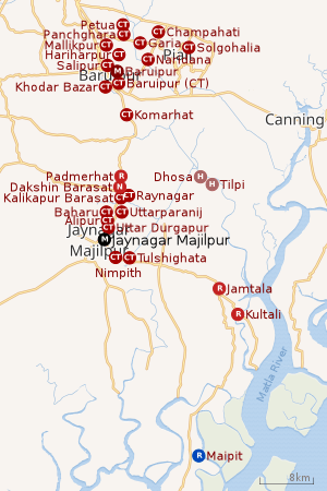 |
| Cities and towns in the southern part of Baruipur subdivision (including Baruipur, Jaynagar I & II, Kultali CD blocks) in South 24 Parganas district M: municipal city/ town, CT: census town, R: rural/ urban centre, N: neighbourhood, H: historical place/ religious centre Places linked with coastal activity are marked in blue Owing to space constraints in the small map, the actual locations in a larger map may vary slightly |
Area Overview
Baruipur subdivision is a rural subdivision with moderate levels of urbanization. 31.05% of the population live in the urban areas and 68.95% live in the rural areas. In the southern portion of the subdivision (shown in the map alongside) there are 20 census towns. The entire district is situated in the Ganges Delta and the southern part is covered by the Baruipur-Jaynagar Plain. Archaeological excavations at Dhosa and Tilpi, on the bank of the Piyali River indicate the existence of human habitation around 2,000 years ago.[14][15][16]
Note: The map alongside presents some of the notable locations in the subdivision. All places marked in the map are linked in the larger full screen map.
Location
Jaynagar Majilpur is located at 22°10′38″N 88°25′33″E. It has an average elevation of 8 metres (26 ft).[17]
Raynagar, Kalikapur Barasat, Baharu, Uttarparanij, Alipur and Uttar Durgapur, all in the Jaynagar I CD block, are adjacent to Jaynagar Majilpur. Nimpith and Tulshighata, both in the Jaynagar II CD block, are very close to Jaynagar Majilpur. These nine locations (eight census towns and a municipal city) virtually form a cluster.[18]
Climate
Jaynagar Majilpur is subject to a tropical wet-and-dry climate that is designated Aw under the Köppen climate classification. According to a United Nations Development Programme report, its wind and cyclone zone is very high damage risk.[19]
Temperature
The annual mean temperature is 26.8 °C (80.2 °F); monthly mean temperatures are 19–30 °C (66–86 °F). Summers (March–June) are hot and humid, with temperatures in the low 30s Celsius; during dry spells, maximum temperatures often exceed 40 °C (104 °F) in May and June. Winter lasts for roughly two-and-a-half months, with seasonal lows dipping to 9–11 °C (48–52 °F) in December and January. May is the hottest month, with daily temperatures ranging from 27–37 °C (81–99 °F); January, the coldest month, has temperatures varying from 12–23 °C (54–73 °F). The highest recorded temperature is 43.9 °C (111.0 °F), and the lowest is 5 °C (41 °F). The winter is mild and very comfortable weather pertains over the city throughout this season. Often, in April–June, the city is struck by heavy rains or dusty squalls that are followed by thunderstorms or hailstorms, bringing cooling relief from the prevailing humidity. These thunderstorms are convective in nature, and are known locally as Kal'bôishakhi, or Nor'westers in English.[19]
Rainfall
Rains brought by the Bay of Bengal branch of the south-west summer monsoon lash Jaynagar Majilpur between June and September, supplying it with most of its annual rainfall of about 1,850 mm (73 in). The highest monthly rainfall total occurs in July and August. In these months often incessant rain for days brings live to a stall for the city dwellers. The city receives 2,528 hours of sunshine per year, with maximum sunlight exposure occurring in March. Jaynagar Majilpur has been hit by several cyclones; these include systems occurring in 1737 and 1864 that killed thousands.[19]
| Climate data for Jaynagar Majilpur | |||||||||||||
|---|---|---|---|---|---|---|---|---|---|---|---|---|---|
| Month | Jan | Feb | Mar | Apr | May | Jun | Jul | Aug | Sep | Oct | Nov | Dec | Year |
| Record high °C (°F) | 32.8 (91.0) |
38.4 (101.1) |
41.1 (106.0) |
43.3 (109.9) |
43.7 (110.7) |
43.9 (111.0) |
39.9 (103.8) |
38.4 (101.1) |
38.9 (102.0) |
39.0 (102.2) |
34.9 (94.8) |
32.5 (90.5) |
43.9 (111.0) |
| Mean maximum °C (°F) | 29.8 (85.6) |
33.5 (92.3) |
37.4 (99.3) |
38.5 (101.3) |
38.8 (101.8) |
38.0 (100.4) |
35.9 (96.6) |
35.0 (95.0) |
35.3 (95.5) |
35.1 (95.2) |
32.9 (91.2) |
29.8 (85.6) |
39.8 (103.6) |
| Average high °C (°F) | 25.8 (78.4) |
29.2 (84.6) |
33.5 (92.3) |
35.3 (95.5) |
35.3 (95.5) |
33.8 (92.8) |
32.4 (90.3) |
32.2 (90.0) |
32.4 (90.3) |
32.2 (90.0) |
30.1 (86.2) |
27.0 (80.6) |
31.6 (88.9) |
| Daily mean °C (°F) | 20.0 (68.0) |
23.6 (74.5) |
28.0 (82.4) |
30.4 (86.7) |
30.9 (87.6) |
30.4 (86.7) |
29.4 (84.9) |
29.3 (84.7) |
29.2 (84.6) |
28.1 (82.6) |
25.0 (77.0) |
21.2 (70.2) |
27.1 (80.8) |
| Average low °C (°F) | 14.1 (57.4) |
17.8 (64.0) |
22.4 (72.3) |
25.3 (77.5) |
26.4 (79.5) |
26.8 (80.2) |
26.5 (79.7) |
26.4 (79.5) |
26.0 (78.8) |
24.1 (75.4) |
19.7 (67.5) |
15.2 (59.4) |
22.6 (72.7) |
| Mean minimum °C (°F) | 10.7 (51.3) |
12.9 (55.2) |
17.6 (63.7) |
20.4 (68.7) |
21.5 (70.7) |
23.7 (74.7) |
24.3 (75.7) |
24.4 (75.9) |
23.8 (74.8) |
20.6 (69.1) |
15.4 (59.7) |
11.8 (53.2) |
10.4 (50.7) |
| Record low °C (°F) | 6.7 (44.1) |
7.2 (45.0) |
10.0 (50.0) |
16.1 (61.0) |
17.9 (64.2) |
20.4 (68.7) |
20.6 (69.1) |
22.6 (72.7) |
20.6 (69.1) |
17.2 (63.0) |
10.6 (51.1) |
7.2 (45.0) |
6.7 (44.1) |
| Average rainfall mm (inches) | 10.4 (0.41) |
20.9 (0.82) |
35.2 (1.39) |
58.9 (2.32) |
133.1 (5.24) |
300.6 (11.83) |
396.0 (15.59) |
344.5 (13.56) |
318.1 (12.52) |
180.5 (7.11) |
35.1 (1.38) |
3.2 (0.13) |
1,836.5 (72.30) |
| Average rainy days | 1.1 | 1.7 | 2.2 | 3.4 | 7.0 | 12.8 | 17.7 | 16.9 | 13.9 | 7.4 | 1.3 | 0.5 | 85.9 |
| Average relative humidity (%) (at 17:30 IST) | 61 | 54 | 51 | 62 | 68 | 77 | 82 | 83 | 82 | 75 | 67 | 65 | 69 |
| Mean monthly sunshine hours | 213.9 | 211.9 | 229.4 | 240.0 | 232.5 | 135.0 | 105.4 | 117.8 | 126.0 | 201.5 | 216.0 | 204.6 | 2,234 |
| Mean daily sunshine hours | 6.9 | 7.5 | 7.4 | 8.0 | 7.5 | 4.5 | 3.4 | 3.8 | 4.2 | 6.5 | 7.2 | 6.6 | 6.1 |
| Source: Climate-Data.org (altitude: 8 m)[19] | |||||||||||||
Demographics
| Population of Jaynagar Majilpur | |||
|---|---|---|---|
| Census | Population | %± | |
| 1901 | 8,810 | — | |
| 1911 | 9,245 | 4.9% | |
| 1921 | 8,408 | −9.1% | |
| 1931 | 9,755 | 16.0% | |
| 1941 | 14,218 | 45.8% | |
| 1951 | 13,355 | −6.1% | |
| 1961 | 14,177 | 6.2% | |
| 1971 | 15,218 | 7.3% | |
| 1981 | 16,343 | 7.4% | |
| 1991 | 20,217 | 23.7% | |
| 2001 | 23,315 | 15.3% | |
| 2011 | 25,922 | 11.2% | |
| Source:[20] | |||
As per 2011 Census of India, Jaynagar Majilpur had a total population of 25,922, of which 13,234 (51%) were males and 12,688 (49%) were females. There were 2,277 persons in the age range of 0–6 years. The total number of literates was 20,898 (88.38% of the population 7 years and above).[21]
As of 2001 Census of India, Jaynagar Majilpur had a total population of 23,315. Males constitute 52% of the population and females 48%. It has an average literacy rate of 76%, higher than the national average of 59.5%: male literacy is 82%, and female literacy is 71%. 10% of the population is under 6 years of age.[22]
Civic Administration
Municipality
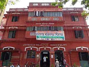
Jaynagar Majilpur Municipality covers an area of 5.85 km2. It has jurisdiction over the Jaynagar Majilpur city. The municipality was established in 1 April 1869. It is divided into 14 administrative wards. As per 2015 municipal election, it is being controlled by the Indian National Congress.[23]
Police Station
Jaynagar police station covers an area of 438.06 km2. It has jurisdiction over the Jaynagar Majilpur Municipality and the Jaynagar I and Jaynagar II CD blocks.[24][25]
Social Scenario
According to the District Human Development Report for the South 24 Parganas, "The district is typically at the lower rung of the ladder in terms of district per capita income compared to other districts of West Bengal… This place also houses the largest proportion of backward people compared to the state… So far as the crime scenario is concerned the economically weaker group, i.e. the women and children, suffer the most in this district".[26]
Transport
Jaynagar Majilpur is on the State Highway 1.[27][28]
Jaynagar Majilpur railway station is on the Sealdah–Namkhana line of the Kolkata Suburban Railway system.[27][29]
Commuters
With the electrification of the railways, suburban traffic has grown tremendously since the 1960s. As of 2005-06, more than 1.7 million (17 lakhs) commuters use the Kolkata Suburban Railway system daily. After the partition of India, refugees from erstwhile East Pakistan and Bangladesh had a strong impact on the development of urban areas in the periphery of Kolkata. The new immigrants depended on Kolkata for their livelihood, thus increasing the number of commuters. Eastern Railway runs 1,272 EMU trains daily.[30]
Education
Jaynagar Institution is a Bengali-medium school for boys. It was established in 1878 and has facilities for teaching from class V to class XII.[31]
Jaynagar Institution For Girls is a Bengali-medium school for girls. It was established in 1947 and has facilities for teaching from class V to class XII.[32]
Jaynagar P C Pal Institution is a Bengali-medium coeducational school. It was established in 1915 and has facilities for teaching from class V to class X.[33]
Majilpur J M Training School is a Bengali-medium school for boys. It was established in 1905 and has facilities for teaching from class V to class XII.[34]
Majilpur Shyam Sundar Balika Vidyalaya is a Bengali-medium school for girls. It was established in 1934 and has facilities for teaching from class V to class X.[35]
Majilpur A K V B Vidyapith is a Bengali-medium school for boys. It was established in 1948 and has facilities for teaching from class V to class X.[36]
Notable People
References
- "Fact and Figures". Wb.gov.in. Retrieved 5 July 2019.
- "52nd REPORT OF THE COMMISSIONER FOR LINGUISTIC MINORITIES IN INDIA" (PDF). Nclm.nic.in. Ministry of Minority Affairs. p. 85. Archived from the original (PDF) on 25 May 2017. Retrieved 5 July 2019.
- "Base Map of Kolkata Metropolitan Area". Kolkata Metropolitan Development Authority. Archived from the original on 28 September 2007. Retrieved 3 September 2007.
- "Special packaging for Jaynagarer Moa ?". The Times of India. 1 February 2016. Retrieved 3 February 2016.
- Bondyopadhyay, Biswanath. Dictionary of The Historical Places of Bengal, 1757–1947. Primus. p. 135. ISBN 978-93-80607-41-2.
- Gangopadhyay, Basudev. Paschimbanga Parichay, 2001. Sishu Sahitya Samsad. p. 70. ISBN 978-81-86806-71-5.
- "District Human Development Report: South 24 Parganas". Pages 3-4, Chapter I: South 24 Parganas: An overview. Department of Planning and Statistics, Government of West Bengal. Archived from the original on 5 October 2016. Retrieved 17 October 2019.
- "Temples and Legends of Bengal". Pages 5-7: The Temples in 24 Parganas. Hindu Books. Archived from the original on 27 June 2007. Retrieved 5 January 2007.
- Sengupta, Nitish. History of The Bengali-speaking People, 2001/2002. UBS Publishers’ Distributors Pvt. Ltd. pp. 132–137. ISBN 81-7476-355-4.
- McCutchion, David J., Late Mediaeval Temples of Bengal, first published 1972, reprinted 2017, p. 78, The Asiatic Society of Kolkata, ISBN 978-93-81574-65-2
- Sengupta, Subodh Chandra and Bose, Anjali (editors), 1976/1998, Samsad Bangali Charitabhidhan (Biographical dictionary) Vol I, pp. 70-71, Sahitya Samsad, ISBN 81-85626-65-0
- Sengupta, Subodh Chandra and Bose, Anjali (editors), 1976/1998, Samsad Bangali Charitabhidhan (Biographical dictionary) Vol I, pp. 522-523, Sahitya Samsad, ISBN 81-85626-65-0
- Sengupta, Subodh Chandra and Bose, Anjali (editors), 2013, Samsad Bangali Charitabhidhan (Biographical dictionary) Vol I, p. 117, Sahitya Samsad, ISBN 978-81-7955-135-6
- "District Statistical Handbook 2014 South Twety-four Parganas". Table 2.1 , 2.2, 2.4b. Department of Statistics and Programme Implementation, Government of West Bengal. Retrieved 17 October 2019.
- "Census of India 2011, West Bengal, District Census Handbook, South Twentyfour Parganas, Series – 20, Part XII-A, Village and Town Directory" (PDF). Page 13, Physiography. Directorate of Census Operations, West Bengal. Retrieved 17 October 2019.
- "District Human Development Report: South 24 Parganas". Chapter 9: Sundarbans and the Remote Islanders, pp. 290–311. Development & Planning Department, Government of West Bengal, 2009. Archived from the original on 5 October 2016. Retrieved 17 October 2019.
- "Falling Rain Genomics, Inc - Jaynagar Majilpur". Falling Rain Genomics. Retrieved 27 August 2016.
- "Census of India 2011, West Bengal, District Census Handbook, South Twentyfour Parganas, Series – 20, Part XII-A, Village and Town Directory" (PDF). Page 699 - Map of Jaynagar I CD block, Page 725 – Map of Jaynagar II CD block. Directorate of Census Operations, West Bengal. Retrieved 17 October 2019.
- "Climate: Jaynagar Majilpur". Climate Data. Retrieved 14 January 2014.
- "District Census Handbook North Twenty Four Parganas, Census of India 2011, Series 20, Part XII A" (PDF). Section II Town Directory, Pages 781-783 Statement I: Growth History, Pages 799-803. Directorate of Census Operations V, West Bengal. Retrieved 17 October 2019.
- "2011 Census – Primary Census Abstract Data Tables". West Bengal – District-wise. Registrar General and Census Commissioner, India. Retrieved 27 April 2016.
- "Census of India 2001: Data from the 2001 Census, Including Cities and Towns (Provisional)". Census Commission of India. Archived from the original on 16 June 2004. Retrieved 1 November 2008.
- "Jaynagar Majilpur Municipality". Department of Municipal Affairs. Government of West Bengal. Archived from the original on 21 April 2017. Retrieved 18 May 2015.
- "Jaynagar police station". Baruipur police district. West Bengal police. Retrieved 17 October 2019.
- "District Statistical Handbook 2014 South 24 Parganas". Table No. 2.1. Department of Statistics and Programme Implementation, Government of West Bengal. Retrieved 17 October 2019.
- "District Human Development Report: South 24 Parganas". Pages 202-203, Chapter 7: Human Security and Vulnerability. Department of Planning and Statistics, Government of West Bengal. Archived from the original on 5 October 2016. Retrieved 17 October 2019.
- Google maps
- "List of State Highways in West Bengal". West Bengal Traffic Police. Retrieved 7 February 2017.
- "34792 Sealdah–Namkhana Local". Time Table. India Rail Info. Retrieved 17 October 2019.
- Mondal, Bhaswati. "Commuting and Metropolitan Development of Kolkata". ResearchGate. Retrieved 17 October 2019.
- "Jaynagar Institution". ICBSE. Retrieved 17 October 2019.
- "Jaynagar Institution For Girls". ICBSE. Retrieved 17 October 2019.
- "Jaynagar P C Pal Institution". ICBSE. Retrieved 17 October 2019.
- "Majilpur J M Training School". ICBSE. Retrieved 17 October 2019.
- "Majilpur Shyam Sundar Balika Vidyalaya". ICBSE. Retrieved 17 October 2019.
- "Majilpur A K V B Vidyapith". ICBSE. Retrieved 17 October 2019.
External Links


- "Digitize Jaynagar Majilpur". Archived from the original on 10 April 2018. Retrieved 1 February 2020.
| Kolkata Municipal Corporation |
|
|---|---|
| Kolkata Urban Agglomeration Outside KMC |
|
| |