Baribhanga Abad
Baribhanga Abad is a village within the jurisdiction of the Raidighi police station in the Mathurapur II CD block in the Diamond Harbour subdivision of the South 24 Parganas district in the Indian state of West Bengal.
Baribhanga Abad | |
|---|---|
Village | |
 Baribhanga Abad Location in West Bengal  Baribhanga Abad Location in India | |
| Coordinates: 22.0367°N 88.4454°E | |
| Country | |
| State | West Bengal |
| District | South 24 Parganas |
| CD block | Mathurapur II |
| Area | |
| • Total | 10.09 km2 (3.90 sq mi) |
| Elevation | 7 m (23 ft) |
| Population (2011) | |
| • Total | 6,773 |
| • Density | 670/km2 (1,700/sq mi) |
| Languages | |
| • Official | Bengali[1][2] |
| • Additional official | English[1] |
| Time zone | UTC+5:30 (IST) |
| PIN | 743383 |
| Telephone code | +91 3174 |
| Vehicle registration | WB-19 to WB-22, WB-95 to WB-99 |
| Lok Sabha constituency | Mathurapur (SC) |
| Vidhan Sabha constituency | Raidighi |
| Website | www |
Geography
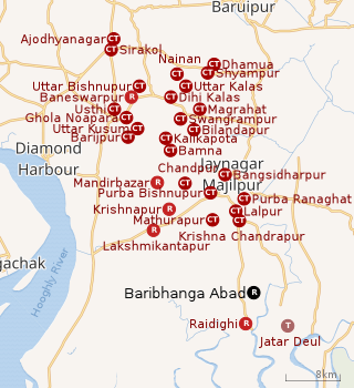 |
| Cities and towns in the eastern part of Diamond Harbour subdivision (including Magrahat I & II, Mandirbazar, Mathurapur I & II CD blocks) in South 24 Parganas district M: municipal city/ town, CT: census town, R: rural/ urban centre, N: neighbourhood, T: religious centre Owing to space constraints in the small map, the actual locations in a larger map may vary slightly |
Area overview
Diamond Harbour subdivision is a rural subdivision with patches of urbanization. Only 14.61% of the population lives in the urban areas and an overwhelming 85.39% lives in the rural areas. In the eastern portion of the subdivision (shown in the map alongside) there are 24 census towns. The entire district is situated in the Ganges Delta and the eastern part of the district is a flat plain area with small towns, many in clusters. Location of places in the larger map varies a little. It is an Open Street Map, while we are using coordinates as in Google maps.[3][4][5]
Note: The map alongside presents some of the notable locations in the subdivision. All places marked in the map are linked in the larger full screen map.
Location
Baribhanga Abad is located at 22.0367°N 88.4454°E.
Demographics
According to the 2011 Census of India, Baribhanga Abad had a total population of 6,773, of which 3,482 (51%) were males and 3,291 (49%) were females. There were 806 persons in the age range of 0-6 years. The total number of literate persons in Baribhanga Abad was 4,302 (72.10% of the population over 6 years).[6]
Civic administration
CD block HQ
The headquarters of the Mathurapur II CD block are located at Baribhanga Abad.[7]
Transport
Bishnupur-Raidighi Road links Baribhanga Abad to the State Highway 1.[8]
Healthcare
There is a primary health centre at Baribhanga Abad, with 6 beds.[9]
References
- "Fact and Figures". Wb.gov.in. Retrieved 5 July 2019.
- "52nd REPORT OF THE COMMISSIONER FOR LINGUISTIC MINORITIES IN INDIA" (PDF). Nclm.nic.in. Ministry of Minority Affairs. p. 85. Archived from the original (PDF) on 25 May 2017. Retrieved 5 July 2019.
- "District Statistical Handbook 2014 South Twety-four Parganas". Table 2.1 , 2.2, 2.4b. Department of Statistics and Programme Implementation, Government of West Bengal. Archived from the original on 2019-01-21. Retrieved 5 December 2019.
- "Census of India 2011, West Bengal, District Census Handbook, South Twentyfour Parganas, Series – 20, Part XII-A, Village and Town Directory" (PDF). Page 13, Physiography. Directorate of Census Operations, West Bengal. Retrieved 5 December 2019.
- "District Human Development Report: South 24 Parganas". Chapter 9: Sundarbans and the Remote Islanders, p 290-311. Development & Planning Department, Government of West Bengal, 2009. Archived from the original on 5 October 2016. Retrieved 5 December 2019.
- "C.D. Block Wise Primary Census Abstract Data(PCA)". West Bengal – District-wise CD Blocks. Registrar General and Census Commissioner, India. Retrieved 21 October 2019.
- "BDO Offices under South 24 Parganas District". West Bengal Public Library Network, Government of West Bengal. Archived from the original on 2018-10-03. Retrieved 21 October 2019.
- Google maps
- "Health & Family Welfare Department" (PDF). Health Statistics – Primary Health Centres. Government of West Bengal. Retrieved 25 November 2019.