Gangasagar
Gangasagar is a village and a gram panchayat within the jurisdiction of the Sagar police station in the Sagar CD block in the Kakdwip subdivision of the South 24 Parganas district in the Indian state of West Bengal.
Gangasagar | |
|---|---|
Village | |
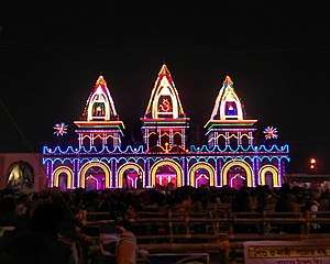 Kapil Muni Ashram | |
 Gangasagar Location in West Bengal  Gangasagar Location in India | |
| Coordinates: 21.6528°N 88.0753°E | |
| Country | |
| State | West Bengal |
| District | South 24 Parganas |
| CD Block | Sagar |
| Area | |
| • Total | 12.26 km2 (4.73 sq mi) |
| Elevation | 4 m (13 ft) |
| Population (2011) | |
| • Total | 10,340 |
| • Density | 840/km2 (2,200/sq mi) |
| Languages | |
| • Official | Bengali[1][2] |
| • Additional official | English[1] |
| Time zone | UTC+5:30 (IST) |
| PIN | 743606 |
| Telephone code | +91 3210 |
| Vehicle registration | WB-19 to WB-22, WB-95 to WB-99 |
| Lok Sabha constituency | Mathurapur (SC) |
| Vidhan Sabha constituency | Sagar |
| Website | www |
Geography
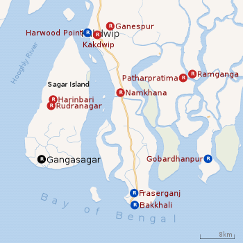 |
| Places in Kakdwip subdivision (Kakdwip, Sagar, Namkhana, Patharpratima CD blocks) in South 24 Parganas district R: rural/ urban centre Places linked with coastal activity are marked in blue Owing to space constraints in the small map, the actual locations in a larger map may vary slightly |
Area overview
Kakdwip subdivision has full rural population. The entire district is situated in the Ganges Delta. The southern part of the delta has numerous channels and islands such as the Henry Island, Sagar Island, Frederick Island and Fraserganj Island. The subdivision is a part of the Sundarbans settlements. A comparatively recent country-wide development is the guarding of the coastal areas by special coastal forces. The area attracts large number of tourists – Gangasagar and Fraserganj-Bakkhali are worth mentioning. Gobardhanpur holds a promise for the future.[3][4][5]
Note: The map alongside presents some of the notable locations in the subdivision. All places marked in the map are linked in the larger full screen map.
Location
Gangasagar is located at 21.6528°N 88.0753°E.
Demographics
According to the 2011 Census of India, Gangasagar had a total population of 10,340, of which 5,228 (51%) were males and 5,112 (49%) were females. There were 1,440 persons in the age range of 0 to 6 years. The total number of literate people in Gangasagar was 7,437 (83.56% of the population over 6 years).[6]
Civic administration
Transport
Gangasagar-Rudranagar-Jibantala Road links Gangasagar to Kachuberia, where a ferry is available across the Muri Ganga River to Harwood Point on the main land. [9]
Healthcare
There is a primary health centre at Gangasagar, with 6 beds.[10]
References
- "Fact and Figures". Wb.gov.in. Retrieved 5 July 2019.
- "52nd Report of the Commissioner for Linguistic Minorities in India" (PDF). Nclm.nic.in. Ministry of Minority Affairs. p. 85. Archived from the original (PDF) on 25 May 2017. Retrieved 5 July 2019.
- "District Statistical Handbook 2014 South Twety-four Parganas". Table 2.1 , 2.2, 2.4b. Department of Statistics and Programme Implementation, Government of West Bengal. Retrieved 5 December 2019.
- "Census of India 2011, West Bengal, District Census Handbook, South Twentyfour Parganas, Series – 20, Part XII-A, Village and Town Directory" (PDF). Page 13, Physigraphy. Directorate of Census Operations, West Bengal. Retrieved 5 December 2019.
- "District Human Development Report: South 24 Parganas". Chapter 9: Sundarbans and the Remote Islanders, p 290-311. Development & Planning Department, Government of West Bengal, 2009. Archived from the original on 5 October 2016. Retrieved 5 December 2019.
- "C.D. Block Wise Primary Census Abstract Data(PCA)". West Bengal – District-wise CD Blocks. Registrar General and Census Commissioner, India. Retrieved 24 October 2019.
- "Sagar Police Station". Sundarban police district. West Bengal police. Retrieved 24 October 2019.
- "District Statistical Handbook 2014 South 24 Parganas". Table No. 2.1. Department of Statistics and Programme Implementation, Government of West Bengal. Retrieved 24 October 2019.
- Google maps
- "Health & Family Welfare Department" (PDF). Health Statistics – Primary Health Centres. Government of West Bengal. Retrieved 11 November 2019.