Liberty (village), New York
Liberty is a village in Sullivan County, New York, United States. The population was 4,392 at the 2010 census.
Liberty, New York | |
|---|---|
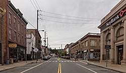 Looking north on Main Street | |
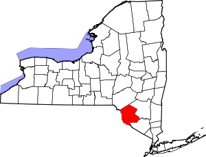
_highlighted.svg.png) Location of Liberty village in Sullivan County, New York | |
| Coordinates: 41°47′52″N 74°44′34″W | |
| Country | United States |
| State | New York |
| County | Sullivan |
| Area | |
| • Total | 2.4 sq mi (6.2 km2) |
| • Land | 2.4 sq mi (6.2 km2) |
| • Water | 0.0 sq mi (0.0 km2) |
| Elevation | 1,506 ft (459 m) |
| Population (2010) | |
| • Total | 4,392 |
| • Estimate (2018)[1] | 4,113 |
| • Density | 1,800/sq mi (710/km2) |
| Time zone | UTC-5 (Eastern (EST)) |
| • Summer (DST) | UTC-4 (EDT) |
| ZIP code | 12754 |
| Area code(s) | 845 Exchanges: 292,295 |
| FIPS code | 36-42224 |
| GNIS feature ID | 0955269 |
The Village of Liberty is centrally located in the Town of Liberty and is adjacent to New York Route 17.
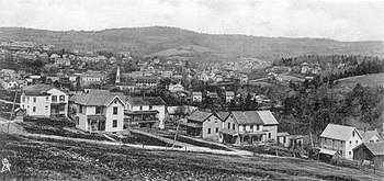
History
While the Town of Liberty was incorporated in 1807, the Village of Liberty was not incorporated as a separate entity until 1870.[2]
The Munson Diner, Liberty Downtown Historic District, St. Paul's Evangelical Lutheran Church, and Town and Country Building are listed on the National Register of Historic Places.[3]
Geography
Liberty is located at 41°47′52″N 74°44′34″W (41.797792, -74.742829).[4]
According to the United States Census Bureau, the village has a total area of 2.4 square miles (6.2 km²). None of the area is covered with water.
Demographics
| Historical population | |||
|---|---|---|---|
| Census | Pop. | %± | |
| 1880 | 478 | — | |
| 1890 | 734 | 53.6% | |
| 1900 | 1,760 | 139.8% | |
| 1910 | 2,072 | 17.7% | |
| 1920 | 2,459 | 18.7% | |
| 1930 | 3,427 | 39.4% | |
| 1940 | 3,788 | 10.5% | |
| 1950 | 4,658 | 23.0% | |
| 1960 | 4,704 | 1.0% | |
| 1970 | 4,514 | −4.0% | |
| 1980 | 4,293 | −4.9% | |
| 1990 | 4,128 | −3.8% | |
| 2000 | 3,975 | −3.7% | |
| 2010 | 4,392 | 10.5% | |
| Est. 2018 | 4,113 | [1] | −6.4% |
| U.S. Decennial Census[5] | |||
At the 2000 census there were 3,975 people, 1,646 households, and 893 families in the village. The population density was 1,660.3 people per square mile (642.2/km²). There were 2,071 housing units at an average density of 865.0 per square mile (334.6/km²). The racial makeup of the village was 76.58% White, 13.89% Black or African American, 0.30% Native American, 1.94% Asian, 5.38% from other races, and 1.91% from two or more races. Hispanic or Latino of any race were 14.21%.[6]
Of the 1,646 households 30.1% had children under the age of 18 living with them, 32.8% were married couples living together, 16.5% had a female householder with no husband present, and 45.7% were non-families. 38.4% of households were one person and 17.2% were one person aged 65 or older. The average household size was 2.30 and the average family size was 3.09.
The age distribution was 25.5% under the age of 18, 7.3% from 18 to 24, 25.2% from 25 to 44, 23.4% from 45 to 64, and 18.6% 65 or older. The median age was 40 years. For every 100 females, there were 84.0 males. For every 100 females age 18 and over, there were 79.7 males.
The median household income was $27,903 and the median family income was $35,265. Males had a median income of $26,823 versus $27,813 for females. The per capita income for the village was $19,180. About 12.7% of families and 15.3% of the population were below the poverty line, including 13.5% of those under age 18 and 12.0% of those age 65 or over.
Notable people
- Charles B. Ward, former US Congressman
See also
References
- "Population and Housing Unit Estimates". Retrieved October 12, 2019.
- Child, Hamilton, Gazetteer and Business Directory for Sullivan County, NY for 1872-73 Archived 2010-04-05 at the Wayback Machine
- "National Register Information System". National Register of Historic Places. National Park Service. March 13, 2009.
- "US Gazetteer files: 2010, 2000, and 1990". United States Census Bureau. 2011-02-12. Retrieved 2011-04-23.
- "Census of Population and Housing". Census.gov. Retrieved June 4, 2015.
- "U.S. Census website". United States Census Bureau. Retrieved 2008-01-31.
External links
Municipalities and communities of Sullivan County, New York, United States | ||
|---|---|---|
| Towns |
|  |
| Villages | ||
| CDPs |
| |
| Other hamlets | ||
| Indian reservation |
| |
| Footnotes | ‡This populated place also has portions in another county or counties. | |