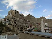
Ladakh
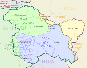
Ladakh (/ləˈdɑːk/)[7] is a region administered by India as a union territory, and constituting a part of the larger region of Kashmir, which has been the subject of dispute between India, Pakistan, and China since 1947.[8][9] It is bordered by the Chinese Tibet Autonomous Region to the east, the Indian state of Himachal Pradesh to the south, both the Indian union territory of Jammu and Kashmir and the Pakistan-administered Gilgit-Baltistan to the west, and the southwest corner of Xinjiang across the Karakoram Pass in the far north. It extends from the Siachen Glacier in the Karakoram range to the north to the main Great Himalayas to the south.[10][11] The eastern end, consisting of the uninhabited Aksai Chin plains, is claimed by the Indian Government as part of Ladakh, and has been under Chinese control since 1962.[12][13] Until 2019, Ladakh was a region of the state of Jammu and Kashmir. In August 2019, the Parliament of India passed an act by which Ladakh became a union territory on 31 October 2019.[14]
Ladakh | |
|---|---|
Region administered by India as a Union Territory | |
    | |
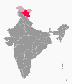 Ladakh in India (lighter shade indicates claimed but not controlled territories) | |
| Coordinates: 34°10′12″N 77°34′48″E | |
| Country | |
| Union territory | 31 October 2019[1] |
| Capital | Leh,[2] Kargil[3] |
| Districts | 2 |
| Government | |
| • Body | Administration of Ladakh |
| • Lieutenant Governor | Radha Krishna Mathur |
| • Member of Parliament | Jamyang Tsering Namgyal (BJP) |
| • High Court | Jammu and Kashmir High Court |
| Area | |
| • Total | 59,146 km2 (22,836 sq mi) |
| Highest elevation | 7,742 m (25,400 ft) |
| Lowest elevation | 2,550 m (8,370 ft) |
| Population (2011) | |
| • Total | 274,289 |
| • Density | 4.6/km2 (12/sq mi) |
| Demonym(s) | Ladakhi |
| Languages | |
| • Official | Hindi, English |
| • Spoken | Ladakhi, Urdu |
| Time zone | UTC+05:30 (IST) |
| ISO 3166 code | IN-LA |
| Vehicle registration | LA 17[6] |
| Website | ladakh |
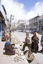
In the past Ladakh gained importance from its strategic location at the crossroads of important trade routes,[15] but since the Chinese authorities closed the borders between Tibet Autonomous Region and Ladakh in the 1960s, international trade has dwindled except for tourism. Since 1974, the Government of India has successfully encouraged tourism in Ladakh. Since Ladakh is a part of the strategically important Kashmir region, the Indian military maintains a strong presence in the region.
The largest town in Ladakh is Leh, followed by Kargil, each of which headquarters a district.[16] The Leh district contains the Indus, Shyok and Nubra river valleys. The Kargil district contains the Suru, Dras and Zanskar river valleys. The main populated regions are the river valleys, but the mountain slopes also support the pastoral Changpa nomads. In contrast to the neighbouring Jammu and Kashmir, Ladakh has a non-Muslim majority. The main religious groups in the region are Muslims (mainly Shia) (46%), Tibetan Buddhists (40%), Hindus (12%) and others (2%).[17][18] Ladakh is one of the most sparsely populated regions in India. As its culture and history are closely related to that of Tibet, it is known as the "Little Tibet".[19]
Ladakh is the largest and the second least populous union territory of India.
Etymology
The Tibetan and Ladakhi name La-dwags ལ་དྭགས (historically transliterated as La-dvags) means "land of high passes". Ladak is its pronunciation in several Tibetan districts, and Ladakh is a transliteration of the Persian spelling.[20]
The region was previously known as Maryul.
History
Ancient history
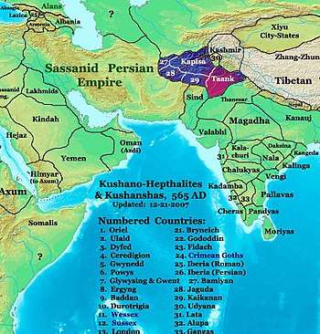
Rock carvings found in many parts of Ladakh indicate that the area has been inhabited from Neolithic times.[21] Ladakh's earliest inhabitants consisted of a mixed Indo-Aryan population of Mons and Dards,[22] who find mention in the works of Herodotus,[lower-alpha 2] and classical writers as well as the Indian Puranas.[23] Around the 1st century, Ladakh was a part of the Kushan Empire. Buddhism spread into western Ladakh from Kashmir in the 2nd century. The 7th-century Buddhist traveller Xuanzang describes the region in his accounts.[24] Xuanzang's term of Ladakh is Mo-lo-so, which has been reconstructed by academics as *Malasa, *Marāsa, or *Mrāsa, which is believed to have been the original name of the region.[25][26]
For much of the first millennium, the western Tibet comprised Zhangzhung kingdom(s), which practised the Bon religion. Sandwiched between Kashmir and Zhangzhung, Ladakh is believed to have been alternatively under the control of one or other of these powers. Academics find strong influences of Zhangzhung language and culture in "upper Ladakh" (from the middle section of the Indus valley to the southeast).[27] The penultimate king of Zhangzhung is said to have been from Ladakh.[28]
From around 660 CE, Central Tibet and China started contesting the "four garrisons" of the Tarim Basin (present day Xinjiang), a struggle that lasted three centuries. Zhangzhung fell victim to Tibet's ambitions in c. 634 and disappeared for ever. Kashmir's Karkota Empire and the Umayyad Caliphate too joined the contest for Xinjiang soon afterwards. Baltistan and Ladakh were at the centre of these struggles.[29] Academics infer from the slant of Ladakhi chronicles that Ladakh may have owed its primary allegiance to Tibet during this time, but that it was more political than cultural. Ladakh remained Buddhist and its culture was not yet Tibetan.[30]
Early medieval history

In the 9th century, Tibet's ruler Langdarma was assassinated and Tibet fragmented. Kyide Nyimagon, Langdarma's great grandson, fled to West Tibet c. 900 CE, and founded a new West Tibetan kingdom at the heart of the old Zhangzhung, now called Ngari in the Tibetan language.
Nyimagon's eldest son, Lhachen Palgyigon, is believed to have conquered the regions to the north, including Ladakh and Rutog. After the death of Nyimagon, his kingdom was divided among his three sons, Palgyigon receiving Ladakh, Rutog, Thok Jalung and an area referred to as "Demchok" (possibly centred around the present day Demchok). The second son received Guge–Purang (called "Ngari Korsum") and the third son received Zanskar and Spiti (to the southwest of Ladakh). This three-way division of Nyimagon's empire was recognised as historic and remembered in the chronicles of all the three regions as a founding narrative.
He gave to each of his sons a separate kingdom, viz., to the eldest Dpal-gyi-gon, Maryul of Mngah-ris, the inhabitants using black bows; ru-thogs [Rutog] of the east and the Gold-mine of Hgog [possibly Thok Jalung]; nearer this way Lde-mchog-dkar-po [Demchok Karpo]; ...
The first West Tibetan dynasty of Maryul founded by Palgyigon lasted five centuries, being weakened towards its end by the conquests of the Mongol/Mughal noble Mirza Haidar Dughlat. Throughout this period the region was called "Maryul", possibly from the original proper name *Mrasa (Xuangzhang's, Mo-lo-so), but in the Tibetan language it was interpreted to mean "lowland" (the lowland of Ngari). Maryul remained staunchly Buddhist during this period, having participated in the second diffusion of Buddhism from India to Tibet via Kashmir and Zanskar.
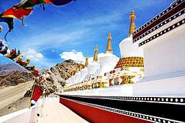 The nine stupas at Thiksey Monastery
Medieval history
Faced with the Muslim conquests in the Indian subcontinent in the 13th century, Ladakh chose to seek and accept guidance in religious matters from Tibet. For nearly two centuries till about 1600, Ladakh was subject to raids and invasions from neighbouring Muslim states. Some of the Ladakhis converted to Islam during this period.
Between the 1380s and early 1510s, many Islamic missionaries propagated Islam and proselytised the Ladakhi people. Sayyid Ali Hamadani, Sayyid Muhammad Nur Baksh and Mir Shamsuddin Iraqi were three important Sufi missionaries who propagated Islam to the locals. Mir Sayyid Ali was the first one to make Muslim converts in Ladakh and is often described as the founder of Islam in Ladakh. Several mosques were built in Ladakh during this period, including in Mulbhe, Padum and Shey, the capital of Ladakh.[32][33] His principal disciple, Sayyid Muhammad Nur Baksh also propagated Islam to Ladakhis and the Balti people rapidly converted to Islam. Noorbakshia Islam is named after him and his followers are only found in Baltistan and Ladakh. During his youth, Sultan Zain-ul-Abidin expelled the mystic Sheikh Zain Shahwalli for showing disrespect to him. The sheikh then went to Ladakh and proselytised many people to Islam. In 1505, Shamsuddin Iraqi, a noted Shia scholar, visited Kashmir and Baltistan. He helped in spreading Shia Islam in Kashmir and converted the overwhelming majority of Muslims in Baltistan to his school of thought.[33]
It is unclear what happened to Islam after this period and it seems to have received a setback. Mirza Muhammad Haidar Dughlat who invaded and briefly conquered Ladakh in 1532, 1545 and 1548, does not record any presence of Islam in Leh during his invasion although Shia Islam and Noorbakshia Islam continued to flourish in other regions of Ladakh.[32][33]
King Bhagan reunited and strengthened Ladakh and founded the Namgyal dynasty (Namgyal means "victorious" in several Tibetan languages) which survives to today. The Namgyals repelled most Central Asian raiders and temporarily extended the kingdom as far as Nepal.[21] During the Balti invasion led by Raja Ali Sher Khan Anchan, many Buddhist temples and artefacts were damaged. According to some accounts after the Namgyals were defeated, Jamyang gave his daughter's hand in marriage to the victorious Ali. Ali took the king and his soldiers as captives. Jamyang was later restored to the throne by Ali and was then given the hand of a Muslim princess in marriage whose name was Gyal Khatun or Argyal Khatoom upon the condition that she would be the first queen and her son will become the next ruler. Historical accounts differ upon who her father was. Some identify Ali's ally and Raja of Khaplu Yabgo Shey Gilazi as her father, while others identify Ali himself as the father.[34][35][36][37][38][39] In the early 17th century efforts were made to restore destroyed artefacts and gonpas by Sengge Namgyal, the son of Jamyang and Gyal and the kingdom expanded into Zangskar and Spiti. However, despite a defeat of Ladakh by the Mughals, who had already annexed Kashmir and Baltistan, it retained its independence.
It appears that the Balti conquest of Ladakh took place in about 1594 CE which was the era of Namgyal dynasty by Balti king Ali Sher Khan Anchan. Legends show that the Balti army obsessed with success advanced as far as Purang, in the valley of Mansarwar Lake, and won the admiration of their enemies and friends. The Raja of Ladakh sued for peace and, since Ali Sher Khan's intention was not to annexe Ladakh, he agreed subject to the condition that the village of Ganokh and Gagra Nullah should be ceded to Skardu and he (the Ladakhi Raja) should pay annual tribute. This tribute was paid through the Gonpa (monastery) of Lama Yuru till the Dogra conquest of Ladakh. Hashmatullah records that the Head Lama of the said Gonpa had admitted before him the payment of yearly tribute to Skardu Darbar till the Dogra conquest of Ladakh.[40]

Islam begins to take root in the Leh area in the beginning of the 17th century after the Balti invasion and the marriage of Gyal to Jamyang. A large group of Muslim servants and musicians were sent along with Gyal to Ladakh and private mosques were built where they could pray. The Muslim musicians later settled in Leh. Several hundred Baltis migrated to the kingdom and according to oral tradition many Muslim traders were granted land to settle. Many other Muslims were invited over the following years for various purposes.[41]
In the late 17th century, Ladakh sided with Bhutan in its dispute with Tibet which, among other reasons, resulted in its invasion by the Tibetan Central Government. This event is known as the Tibet–Ladakh–Mughal war of 1679–1684.[42] Kashmiri historians assert that the king converted to Islam in return for the assistance by Mughal Empire after this however Ladakhi chronicles do not mention such a thing. The king agreed to pay tribute to the Mughals in return for defending the kingdom.[43][44] The Mughals however withdrew after being paid off by the 5th Dalai Lama.[45] With the help of reinforcements from Galdan Boshugtu Khan, Khan of the Zungar Empire, the Tibetans attacked again in 1684. The Tibetans were victorious and concluded a treaty with Ladakh then they retreated back to Lhasa in December 1684. The Treaty of Tingmosgang in 1684 settled the dispute between Tibet and Ladakh but severely restricted Ladakh's independence.
 Likir Monastery, Ladakh
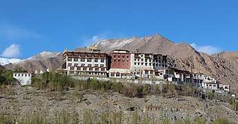 Phyang Gompa, Ladakh
 Hemis Monastery in the 1870s
Princely state of Jammu and Kashmir
In 1834, the Sikh Zorawar Singh, a general of Raja Gulab Singh of Jammu invaded and annexed Ladakh to Jammu under the suzerainty of the Sikh Empire. After the defeat of the Sikhs in the First Anglo-Sikh War, the state of Jammu and Kashmir was established as a separate princely state under British suzerainty. The Namgyal family was given the jagir of Stok, which it nominally retains to this day. European influence began in Ladakh in the 1850s and increased. Geologists, sportsmen, and tourists began exploring Ladakh. In 1885, Leh became the headquarters of a mission of the Moravian Church.
Ladakh was administered as a wazarat during the Dogra rule, with a governor termed wazir-e-wazarat. It had three tehsils, based at Leh, Skardu and Kargil. The headquarters of the wazarat was at Leh for six months of the year and at Skardu for six months. When the legislative assembly called Praja Sabha was established in 1934, Ladakh was given two nominated seats in the assembly.
Ladakh was claimed as part of Tibet by Phuntsok Wangyal, a Tibetan Communist leader.[46]
Indian state of Jammu and Kashmir
At the time of the partition of India in 1947, the Dogra ruler Maharaja Hari Singh signed the Instrument of Accession to India. Pakistani raiders from Gilgit had reached Ladakh and military operations were initiated to evict them. The wartime conversion of the pony trail from Sonamarg to Zoji La by army engineers permitted tanks to move up and successfully capture the pass. The advance continued. Dras, Kargil and Leh were liberated and Ladakh cleared of the infiltrators.[47]
In 1949, China closed the border between Nubra and Xinjiang, blocking old trade routes. In 1955 China began to build roads connecting Xinjiang and Tibet through the Aksai Chin area. The Indian effort to retain control of Aksai Chin led to the Sino-Indian War of 1962, which India lost. China also built the Karakoram highway jointly with Pakistan. India built the Srinagar-Leh Highway during this period, cutting the journey time between Srinagar and Leh from 16 days to two. The route, however, remains closed during the winter months due to heavy snowfall. Construction of a 6.5 km (4.0 mi) tunnel across Zoji La pass is under consideration to make the route functional throughout the year.[21][48]
The Kargil War of 1999, codenamed "Operation Vijay" by the Indian Army, saw infiltration by Pakistani troops into parts of Western Ladakh, namely Kargil, Dras, Mushkoh, Batalik and Chorbatla, overlooking key locations on the Srinagar-Leh highway. Extensive operations were launched in high altitudes by the Indian Army with considerable artillery and air force support. Pakistani troops were evicted from the Indian side of the Line of Control which the Indian government ordered was to be respected and which was not crossed by Indian troops. The Indian government was criticised by the Indian public because India respected geographical co-ordinates more than India's opponents: Pakistan and China.[49]
The Ladakh region was divided into the Kargil and Leh districts in 1979. In 1989, there were violent riots between Buddhists and Muslims. Following demands for autonomy from the Kashmiri dominated state government, the Ladakh Autonomous Hill Development Council was created in the 1990s. Leh and Kargil districts now each have their own locally elected Hill Councils with some control over local policy and development funds. In 1991, a Peace Pagoda was erected in Leh by Nipponzan Myohoji.
There was a heavy presence of Indian Army and Indo-Tibetan Border Police forces in Ladakh. These forces and People's Liberation Army forces from China have, since the 1962 Sino-Indian War, had frequent stand-offs along the Lakakh portion of the Line of Actual Control. Out of the 857-square-kilometre-long (331 sq mi) border in Ladakh, only 368 km2 (142 sq mi) is the International Border, and the remaining 489 km2 (189 sq mi) is Line of Actual Control.[50][51] The stand-off involving the most troops was in September 2014 in the disputed Chumar region when 800 to 1,000 Indian troops and 1,500 Chinese troops came into close proximity to each other.[52]
Division
In February 2019, Ladakh became a separate Revenue and Administrative Division within Jammu and Kashmir, having previously been part of the Kashmir Division. As a division, Ladakh was granted its own Divisional Commissioner and Inspector General of Police.[53]
Leh was initially chosen to be the headquarters of the new division however, following protests, it was announced that Leh and Kargil will jointly serve as the divisional headquarters, each hosting an Additional Divisional Commissioner to assist the Divisional Commissioner and Inspector General of Police who will spend half their time in each town.[54]
Union territory of Ladakh
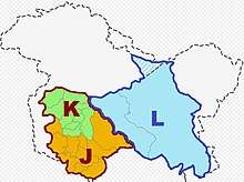
Some activists from Leh in recent times called for Ladakh to be constituted as a union territory because of perceived unfair treatment by Kashmir and Ladakh's cultural differences with predominantly Muslim Kashmir valley, while some people in Kargil opposed union territory status for Ladakh.[21][55]
In August 2019, a reorganisation act was passed by the Parliament of India which contained provisions to reconstitute Ladakh as a union territory, separate from the rest of Jammu and Kashmir on 31 October 2019.[1][14][56][57] Under the terms of the act, the union territory is administered by a Lieutenant Governor acting on behalf of the Central Government of India and does not have an elected legislative assembly or chief minister. Each district within the union territory continues to elect an autonomous district council as done previously.[58]
Geography
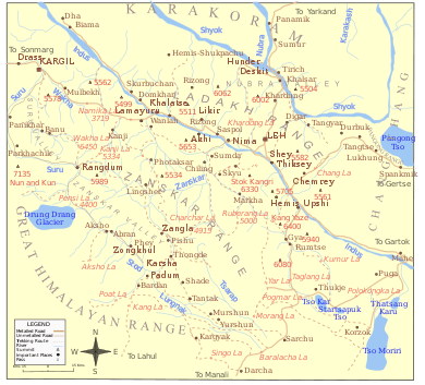
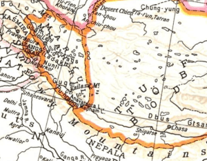
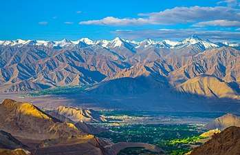
Ladakh is the highest plateau in India with much of it being over 3,000 m (9,800 ft).[18] It extends from the Himalayan to the Kunlun[59] Ranges and includes the upper Indus River valley.
Historically, the region included the Baltistan (Baltiyul) valleys (now mostly in Pakistani administered part of Kashmir), the entire upper Indus Valley, the remote Zanskar, Lahaul and Spiti to the south, much of Ngari including the Rudok region and Guge in the east, Aksai Chin in the northeast, and the Nubra Valley to the north over Khardong La in the Ladakh Range. Contemporary Ladakh borders Tibet to the east, the Lahaul and Spiti regions to the south, the Vale of Kashmir, Jammu and Baltiyul regions to the west, and the southwest corner of Xinjiang across the Karakoram Pass in the far north. The historic but imprecise divide between Ladakh and the Tibetan Plateau commences in the north in the intricate maze of ridges east of Rudok including Aling Kangri and Mavang Kangri, and continues southeastward toward northwestern Nepal. Before partition, Baltistan, now under Pakistani control, was a district in Ladakh. Skardo was the winter capital of Ladakh while Leh was the summer capital.
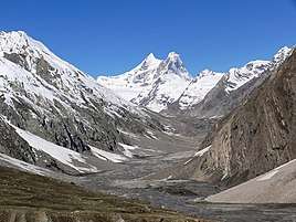
The mountain ranges in this region were formed over 45 million years by the folding of the Indian Plate into the more stationary Eurasian Plate. The drift continues, causing frequent earthquakes in the Himalayan region.[lower-alpha 3][60] The peaks in the Ladakh Range are at a medium altitude close to the Zoji-la (5,000–5,500 m or 16,400–18,000 ft) and increase toward southeast, culminating in the twin summits of Nun-Kun (7,000 m or 23,000 ft).
The Suru and Zanskar valleys form a great trough enclosed by the Himalayas and the Zanskar Range. Rangdum is the highest inhabited region in the Suru valley, after which the valley rises to 4,400 m (14,400 ft) at Pensi-la, the gateway to Zanskar. Kargil, the only town in the Suru valley, is the second most important town in Ladakh. It was an important staging post on the routes of the trade caravans before 1947, being more or less equidistant, at about 230 kilometres from Srinagar, Leh, Skardu and Padum. The Zangskar valley lies in the troughs of the Stod and the Lungnak rivers. The region experiences heavy snowfall; the Pensi-la is open only between June and mid-October. Dras and the Mushkoh Valley form the western extremity of Ladakh.
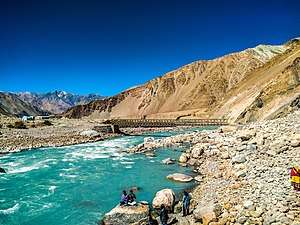
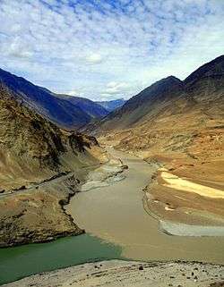
The Indus River is the backbone of Ladakh. Most major historical and current towns – Shey, Leh, Basgo and Tingmosgang (but not Kargil), are close to the Indus River. After the Indo-Pakistani War of 1947, the stretch of the Indus flowing through Ladakh became the only part of this river, which is greatly venerated in the Hindu religion and culture, that still flows through India.
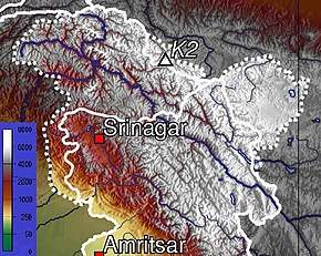
The Siachen Glacier is in the eastern Karakoram Range in the Himalaya Mountains along the disputed India-Pakistan border. The Karakoram Range forms a great watershed that separates China from the Indian subcontinent and is sometimes called the "Third Pole." The glacier lies between the Saltoro Ridge immediately to the west and the main Karakoram Range to the east. At 76 km (47 mi) long, it is the longest glacier in the Karakoram and second-longest in the world's non-polar areas. It falls from an altitude of 5,753 m (18,875 ft) above sea level at its source at Indira Col on the China border down to 3,620 m (11,880 ft) at its snout. Saser Kangri is the highest peak in the Saser Muztagh, the easternmost subrange of the Karakoram Range in India, Saser Kangri I having an altitude of 7,672 m (25,171 ft).
The Ladakh Range has no major peaks; its average height is a little less than 6,000 m (20,000 ft), and few of its passes are less than 5,000 m (16,000 ft). The Pangong range runs parallel to the Ladakh Range for about 100 km (62 mi) northwest from Chushul along the southern shore of the Pangong Lake. Its highest point is about 6,700 m (22,000 ft) and the northern slopes are heavily glaciated. The region comprising the valley of the Shayok and Nubra rivers is known as Nubra. The Karakoram Range in Ladakh is not as mighty as in Baltistan. The massifs to the north and east of the Nubra–Siachen line include the Apsarasas Group (highest point at 7,245 m or 23,770 ft) the Rimo Muztagh (highest point at 7,385 m or 24,229 ft) and the Teram Kangri Group (highest point at 7,464 m or 24,488 ft) together with Mamostong Kangri (7,526 m or 24,692 ft) and Singhi Kangri (7,202 m or 23,629 ft). North of the Karakoram lies the Kunlun. Thus, between Leh and eastern Central Asia there is a triple barrier – the Ladakh Range, Karakoram Range, and Kunlun. Nevertheless, a major trade route was established between Leh and Yarkand.
Ladakh is a high altitude desert as the Himalayas create a rain shadow, generally denying entry to monsoon clouds. The main source of water is the winter snowfall on the mountains. Recent flooding in the region (e.g., the 2010 floods) has been attributed to abnormal rain patterns and retreating glaciers, both of which have been found to be linked to global climate change.[61] The Leh Nutrition Project, headed by Chewang Norphel, also known as the "Glacier Man", creates artificial glaciers as one solution for retreating glaciers.[62][63]
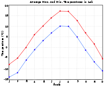
The regions on the north flank of the Himalayas – Dras, the Suru valley and Zangskar – experience heavy snowfall and remain cut off from the rest of the region for several months in the year, as the whole region remains cut off by road from the rest of the country. Summers are short, though they are long enough to grow crops. The summer weather is dry and pleasant. Temperature ranges are from 3 to 35 °C (37 to 95 °F) in summer and minimums range from −20 to −35 °C (−4 to −31 °F) in winter.[64]
Zanskar is the main river of the region along with its tributaries. The Zanskar gets frozen during winter and the famous Chadar trek takes place on this magnificent frozen river.
Flora and fauna

Vegetation is extremely sparse in Ladakh except along streambeds and wetlands, on high slopes, and irrigated places. About 1250 plant species, including crops, were reported from Ladakh.[65] The plant Ladakiella klimesii, growing up to 6150 m a.s.l., was first described here and named after this region.[66] The first European to study the wildlife of this region was William Moorcroft in 1820, followed by Ferdinand Stoliczka, an Austrian-Czech palaeontologist, who carried out a massive expedition there in the 1870s.
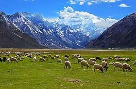
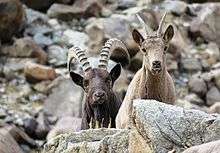
The bharal or blue sheep is the most abundant mountain ungulate in the Ladakh region, although it is not found in some parts of Zangskar and Sham areas.[67] The Asiatic ibex is a very elegant mountain goat that is distributed in the western part of Ladakh. It is the second most abundant mountain ungulate in the region with a population of about 6000 individuals. It is adapted to rugged areas where it easily climbs when threatened.[68] The Ladakhi Urial is another unique mountain sheep that inhabits the mountains of Ladakh. The population is declining, however, and there are not more than 3000 individuals left in Ladakh.[69] The urial is endemic to Ladakh, where it is distributed only along two major river valleys: the Indus and Shayok. The animal is often persecuted by farmers whose crops are allegedly damaged by it. Its population declined precipitously in the last century due to indiscriminate shooting by hunters along the Leh-Srinagar highway. The Tibetan argali or Nyan is the largest wild sheep in the world, standing 1.1 to 1.2 metres (3.5 to 4 ft) at the shoulder with the horn measuring 900–1,000 mm (35–39 in). It is distributed on the Tibetan plateau and its marginal mountains encompassing a total area of 2.5 million km2 (0.97 million sq mi). There is only a small population of about 400 animals in Ladakh. The animal prefers open and rolling terrain as it runs, unlike wild goats that climb into steep cliffs, to escape from predators.[70] The endangered Tibetan antelope, known as chiru in Indian English, or Ladakhi tsos, has traditionally been hunted for its wool (shahtoosh) which is a natural fibre of the finest quality and thus valued for its light weight and warmth and as a status symbol. The wool of chiru must be pulled out by hand, a process done after the animal is killed. The fibre is smuggled into Kashmir and woven into exquisite shawls by Kashmiri workers. Ladakh is also home to the Tibetan gazelle, which inhabits the vast rangelands in eastern Ladakh bordering Tibet.[71]
The kiang, or Tibetan wild ass, is common in the grasslands of Changthang, numbering about 2,500 individuals. These animals are in conflict with the nomadic people of Changthang who hold the Kiang responsible for pasture degradation.[72] There are about 200 snow leopards in Ladakh of an estimated 7,000 worldwide. The Hemis High Altitude National Park in central Ladakh is an especially good habitat for this predator as it has abundant prey populations. The Eurasian lynx, is another rare cat that preys on smaller herbivores in Ladakh. It is mostly found in Nubra, Changthang and Zangskar.[73] The Pallas's cat, which looks somewhat like a house cat, is very rare in Ladakh and not much is known about the species. The Tibetan wolf, which sometimes preys on the livestock of the Ladakhis, is the most persecuted amongst the predators.[74] There are also a few brown bears in the Suru Valley and the area around Dras. The Tibetan sand fox has been discovered in this region.[75] Among smaller animals, marmots, hares, and several types of pika and vole are common.[76]
Landform
Scant precipitation makes Ladakh a high-altitude desert with extremely scarce vegetation over most of its area. Natural vegetation mainly occurs along water courses and on high altitude areas that receive more snow and cooler summer temperatures. Human settlements, however, are richly vegetated due to irrigation.[77] Natural vegetation commonly seen along watercourses includes seabuckthorn (Hippophae spp.), wild roses of pink or yellow varieties, tamarisk (Myricaria spp.), caraway, stinging nettles, mint, Physochlaina praealta, and various grasses.[78]
Administration

Under the terms of the Jammu and Kashmir Reorganisation Act, Ladakh is administered as a union territory without a legislative assembly or elected government. The head of government is a Lieutenant Governor appointed by the President of India who is assisted by civil servants of the Indian Administrative Service.[79]
Districts
Ladakh is divided into two districts:
| Name of District | Headquarters | Area (km2) | Population 2001 Census | Population 2011 Census |
|---|---|---|---|---|
| Kargil District | Kargil | 14,036 | 119,307 | 143,388 |
| Leh District | Leh | 45,110 | 117,232 | 147,104 |
| Total | 2 | 59,146 | 236,539 | 290,492 |
Autonomous District Councils
Each district of Ladakh is administered by an autonomous district council, they are:
The two autonomous district councils work with village panchayats to take decisions on economic development, healthcare, education, land use, taxation, and local governance which are further reviewed at the block headquarters in the presence of the chief executive councillor and executive councillors.[80] The government of Jammu and Kashmir looks after law and order, the judicial system, communications and the higher education in the region.
The two autonomous district councils continue to exist following the formation of the union territory of Ladakh on 31 October 2019.[58]
Law enforcement and justice
Ladakh is under the jurisdiction of the Jammu and Kashmir High Court.[81] The union territory of Ladakh has its own police force headed by a Director general of police.[82]
Ladakh in the Parliament of India
Ladakh sends one member (MP) to the lower house of the Indian parliament the Lok Sabha. The MP for the Ladakh constituency in the current Lok Sabha is Jamyang Tsering Namgyal a candidate from the Bharatiya Janata Party (BJP).[83][84]
Economy
The land is irrigated by a system of channels which funnel water from the ice and snow of the mountains. The principal crops are barley and wheat. Rice was previously a luxury in the Ladakhi diet, but, subsidised by the government, has now become a cheap staple.[18]
Naked barley (Ladakhi: nas, Urdu: grim) was traditionally a staple crop all over Ladakh. Growing times vary considerably with altitude. The extreme limit of cultivation is at Korzok, on the Tso-moriri lake, at 4,600 m (15,100 ft), which has what are widely considered to be the highest fields in the world.[18]
A minority of Ladakhi people were also employed as merchants and caravan traders, facilitating trade in textiles, carpets, dyestuffs and narcotics between Punjab and Xinjiang. However, since the Chinese Government closed the borders between Tibet Autonomous Region and Ladakh, this international trade has completely dried up.[21][85]
Indus river flowing in the Ladakh region is endowed with vast hydropower potential. Solar and wind power potentials are also substantial. Though the region is a remote hilly area without all-weather roads, the area is also rich in limestone deposits to manufacture cement from the locally available cheap electricity for various construction needs.[86]
Since 1974, the Indian Government has encouraged a shift in trekking and other tourist activities from the troubled Kashmir region to the relatively unaffected areas of Ladakh. Although tourism employs only 4% of Ladakh's working population, it now accounts for 50% of the region's GNP.[21]
This era is recorded in Arthur Neves The Tourist's Guide to Kashmir, Ladakh, and Skardo, first published in 1911.[85]
Transportation
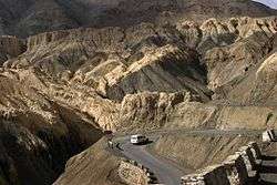
There are about 1,800 km (1,100 mi) of roads in Ladakh of which 800 km (500 mi) are surfaced.[87] The majority of roads in Ladakh are looked after by the Border Roads Organisation.
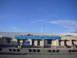
There is an airport in Leh, Kushok Bakula Rimpochee Airport, from which there are daily flights to Delhi and weekly flights to Srinagar and Jammu. There are two airstrips at Daulat Beg Oldie and Fukche for military transport.[88] The airport at Kargil, Kargil Airport, was intended for civilian flights but is currently is used by the Indian Army. The airport is a political issue for the locals who argue that the airport should serve its original purpose, i.e., should open up for civilian flights. Since past few years the Indian Air Force has been operating AN-32 air courier service to transport the locals during the winter seasons to Jammu, Srinagar and Chandigarh.[89][90] A private aeroplane company Air Mantra landed a 17-seater aircraft at the airport, in presence of dignitaries like the Chief Minister Omar Abdullah, marking the first ever landing by a civilian airline company at Kargil Airport.[91][92]
Demographics
Languages of Ladakh (2011)[94]
People of Dard descent predominate in Dras and Dha-Hanu areas. The residents of the Dha-Hanu area, known as Brokpa, are predominately followers of Islam while small minorities follow Tibetan Buddhism and Hinduism[95] and most Brokpa have preserved much of their original Dardic traditions and customs. The Dards of Dras, however, have converted to Islam and have been strongly influenced by their Kashmiri neighbours. The Mons are believed to be descendants of earlier Indian settlers in Ladakh, and traditionally worked as musicians, blacksmiths, and carpenters. The region's population is split roughly in half between the districts of Leh and Kargil. 76.87% population of Kargil is Muslim (mostly Shia),[96] with a total population of 140,802, while that of Leh is 66.40% Buddhist, with a total population of 133,487, as per the 2011 census.[97][98] The principal language of Ladakh is Ladakhi, a Tibetan language. Educated Ladakhis usually know Hindi, Urdu and often English. Within Ladakh, there is a range of dialects, so that the language of the Chang-pa people may differ markedly from that of the Purig-pa in Kargil, or the Zangskaris, but they are all mutually comprehensible. Due to its position on important trade routes, the language of Leh is enriched with foreign words. Traditionally, Ladakhi had no written form distinct from classical Tibetan, but a number of Ladakhi writers have started using the Tibetan script to write the colloquial tongue. Administrative work and education are carried out in English; although Urdu was used to a great extent in the past, now only land records and some police records are kept in Urdu.
The total birth rate (TBR) in 2001 was 22.44, while it was 21.44 for Muslims and 24.46 for Buddhists. Brokpas had the highest TBR at 27.17 and Arghuns had the lowest at 14.25. TFR was 2.69 with 1.3 in Leh and 3.4 in Kargil. For Buddhists it was 2.79 and for Muslims it was 2.66. Baltis had a TFR of 3.12 and Arghuns had a TFR of 1.66. The total death rate was 15.69, with Muslims having 16.37 and Buddhists having 14.32. Highest was for Brokpas at 21.74 and lowest was for Bodhs at 14.32.[99]
| Year[lower-alpha 4] | Leh District | Kargil District | ||||
|---|---|---|---|---|---|---|
| Population | Percentage change | Females per 1000 males | Population | Percentage change | Females per 1000 males | |
| 1951 | 40,484 | — | 1011 | 41,856 | — | 970 |
| 1961 | 43,587 | 0.74 | 1010 | 45,064 | 0.74 | 935 |
| 1971 | 51,891 | 1.76 | 1002 | 53,400 | 1.71 | 949 |
| 1981 | 68,380 | 2.80 | 886 | 65,992 | 2.14 | 853 |
| 2001 | 117,637 | 2.75 | 805 | 115,287 | 2.83 | 901 |
The sex ratio for Leh district declined from 1011 females per 1000 males in 1951 to 805 in 2001, while for Kargil district it declined from 970 to 901.[100] The urban sex ratio in both the districts is about 640. The adult sex ratio reflects large numbers of mostly male seasonal and migrant labourers and merchants. About 84% of Ladakh's population lives in villages.[101] The average annual population growth rate from 1981 to 2001 was 2.75% in Leh District and 2.83% in Kargil district.[100]
Culture
Ladakhi culture is similar to Tibetan culture.[102]
Cuisine
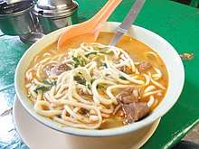
Ladakhi food has much in common with Tibetan food, the most prominent foods being thukpa (noodle soup) and tsampa, known in Ladakhi as ngampe (roasted barley flour). Edible without cooking, tsampa makes useful trekking food. A dish that is strictly Ladakhi is skyu, a heavy pasta dish with root vegetables. As Ladakh moves toward a cash-based economy, foods from the plains of India are becoming more common.[103] As in other parts of Central Asia, tea in Ladakh is traditionally made with strong green tea, butter, and salt. It is mixed in a large churn and known as gurgur cha, after the sound it makes when mixed. Sweet tea (cha ngarmo) is common now, made in the Indian style with milk and sugar. Most of the surplus barley that is produced is fermented into chang, an alcoholic beverage drunk especially on festive occasions.[104]
Music and dance
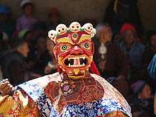
The music of Ladakhi Buddhist monastic festivals, like Tibetan music, often involves religious chanting in Tibetan as an integral part of the religion. These chants are complex, often recitations of sacred texts or in celebration of various festivals. Yang chanting, performed without metrical timing, is accompanied by resonant drums and low, sustained syllables. Religious mask dances are an important part of Ladakh's cultural life. Hemis monastery, a leading centre of the Drukpa tradition of Buddhism, holds an annual masked dance festival, as do all major Ladakhi monasteries. The dances typically narrate a story of the fight between good and evil, ending with the eventual victory of the former.[105] Weaving is an important part of traditional life in eastern Ladakh. Both women and men weave, on different looms.[106]
Sport
%2C_Ladakh%2C_late_19th-early_20th_century.JPG)
The most popular sport in Ladakh is ice hockey, which is played only on natural ice generally mid-December through mid-February.[107] Cricket is also very popular.
Archery is a traditional sport in Ladakh, and many villages hold archery festivals, which are as much about traditional dancing, drinking and gambling, as they are about the sport. The sport is conducted with strict etiquette, to the accompaniment of the music of surna and daman (shehnai and drum). Polo, the other traditional sport of Ladakh, is indigenous to Baltistan and Gilgit, and was probably introduced into Ladakh in the mid-17th century by King Singge Namgyal, whose mother was a Balti princess.[108]
Polo, popular among the Baltis, is an annual affair in Drass region of Kargil district.[109][110][111][112]
Social status of women
.jpg)
A feature of Ladakhi society that distinguishes it from the rest of the state is the high status and relative emancipation enjoyed by women compared to other rural parts of India. Fraternal polyandry and inheritance by primogeniture were common in Ladakh until the early 1940s when these were made illegal by the government of Jammu and Kashmir. However, the practice remained in existence into the 1990s especially among the elderly and the more isolated rural populations.[113] Another custom is known as khang-bu, or 'little house', in which the elders of a family, as soon as the eldest son has sufficiently matured, retire from participation in affairs, yielding the headship of the family to him and taking only enough of the property for their own sustenance.[18]
Traditional medicine
Tibetan medicine has been the traditional health system of Ladakh for over a thousand years. This school of traditional healing contains elements of Ayurveda and Chinese medicine, combined with the philosophy and cosmology of Tibetan Buddhism. For centuries, the only medical system accessible to the people have been the amchi, traditional doctors following the Tibetan medical tradition. Amchi medicine remains a component of public health, especially in remote areas.[114]
Programmes by the government, local and international organisations are working to develop and rejuvenate this traditional system of healing.[114][115] Efforts are underway to preserve the intellectual property rights of amchi medicine for the people of Ladakh. The government has also been trying to promote the sea buckthorn in the form of juice and jam, as some claim it possess medicinal properties.
Education
.jpg)
According to the 2001 census, the overall literacy rate in Leh District is 62% (72% for males and 50% for females), and in Kargil District 58% (74% for males and 41% for females).[116] Traditionally there was little or nothing by way of formal education except in the monasteries. Usually, one son from every family was obliged to master the Tibetan script in order to read the holy books.[18]
The Moravian Mission opened a school in Leh in October 1889, and the Wazir-i Wazarat (ex officio Joint Commissioner with a British officer) of Baltistan and Ladakh ordered that every family with more than one child should send one of them to school. This order met with great resistance from the local people who feared that the children would be forced to convert to Christianity. The school taught Tibetan, Urdu, English, Geography, Sciences, Nature study, Arithmetic, Geometry and Bible study.[22] It is still in existence today. The first local school to provide western education was opened by a local Society called "Lamdon Social Welfare Society" in 1973. Later, with support from Dalai Lama and some international organisations, the school, now known as Lamdon Model Senior Secondary School, has grown to accommodate approximately two thousand pupils in several branches. It prides itself on preserving Ladakhi tradition and culture.[117]
Schools are well distributed throughout Ladakh but 75% of them provide only primary education. 65% of children attend school, but absenteeism of both students and teachers remains high. In both districts the failure rate at school-leaving level (class X) had for many years been around 85–95%, while of those managing to scrape through, barely half succeeded in qualifying for college entrance (class XII). Before 1993, students were taught in Urdu until they were 14, after which the medium of instruction shifted to English.
In 1994 the Students' Educational and Cultural Movement of Ladakh (SECMOL) launched Operation New Hope (ONH), a campaign to provide "culturally appropriate and locally relevant education" and make government schools more functional and effective.[118]
Eliezer Joldan Memorial College, a government degree college, enables students to pursue higher education without having to leave Ladakh.[119]
In December 2019, the union minister of state for home affairs Mr G Kishan Reddy, in a written response has stated in Parliament that the Government of India has approved to establish a Medical College in the district of Leh.[120]
Media
The government radio broadcaster All India Radio (AIR)[121] and government television station Doordarshan[122] have stations in Leh that broadcast local content for a few hours a day. Beyond that, Ladakhis produce feature films that are screened in auditoriums and community halls. They are often made on fairly modest budgets.[123]
There are a handful of private news outlets.
- Reach Ladakh Bulletin,[124] a biweekly newspaper in English, is the only print media published by and for Ladakhis.
- Rangyul or Kargil Number is a newspaper published from Kashmir covering Ladakh in English and Urdu.
- Ladags Melong, an initiative of SECMOL, was published from 1992 to 2005 in English and Ladakhi.
- Sintic Magazine, a lifestyle and tourist magazine of Ladakh, was started in 2018 in English.
Some publications that cover Jammu and Kashmir as a whole provide some coverage of Ladakh.
Gallery
 Pensi La
 Shingo La
 Shanti Stupa, Leh
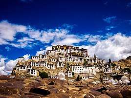 Front of the Thiksey Monastery
.jpg) Likir Monastery
Likir Monastery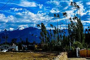 Trees nestled in front of the Himalayas near Leh
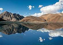
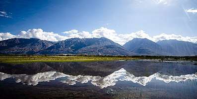 Nubra Valley view with Reflection
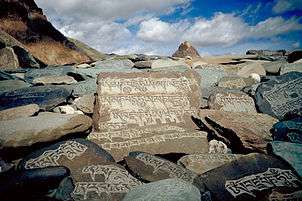 Carved stone tablets, each with the inscription "Om Mani Padme Hum" along the paths of Zanskar
See also
- 2013 Daulat Beg Oldi Incident
- Ancient Futures: Learning from Ladakh (book)
- Baily Bridge
- Balti language
- Baltistan
- Geography of Ladakh
- Ladakhi language
- Ladakh Police
- Ladakh Scouts
- Ladakh University
- Mona Bhan
- Music of Kashmir, Jammu and Ladakh
- Polyandry in Tibet
- Rivers of Jammu and Kashmir
- Tourism in Ladakh
- Wildlife of Ladakh
Notes
- Ladakh has 59,146 km2 (22,836 sq mi) of area controlled by India and 72,971 km2 (28,174 sq mi) of area controlled by Pakistan under Gilgit-Baltistan, which is claimed by India as part of Ladakh. Additionally, it has 5,180 km2 (2,000 sq mi) of area controlled by the People's Republic of China under Trans-Karakoram Tract and 37,555 km2 (14,500 sq mi) of area controlled by the People's Republic of China under Aksai Chin, which is claimed by India as part of Ladakh.
- He mentions twice a people called Dadikai, first along with the Gandarioi, and again in the catalogue of king Xerxes's army invading Greece. Herodotus also mentions the gold-digging ants of Central Asia.
- All of Indian Ladakh is placed in high risk Zone VIII, while areas from Kargil and Zanskar southwestward are in lower risk zones on the earthquake hazard scale.
- Census was not carried out in Jammu and Kashmir in 1991 due to militancy
References
Citations
- http://egazette.nic.in/WriteReadData/2019/210412.pdf
- "Ladakh Gets Civil Secretariat". 17 October 2019.
- Excelsior, Daily (12 November 2019). "LG, UT Hqrs, Head of Police to have Sectts at both Leh, Kargil: Mathur". Retrieved 17 December 2019.
- "MHA.nic.in". MHA.nic.in. Archived from the original on 8 December 2008. Retrieved 21 June 2012.
- "Saltoro Kangri, India/Pakistan". peakbagger.com. Retrieved 9 August 2019.
- http://egazette.nic.in/WriteReadData/2019/214357.pdf
- "Ladakh". Merriam-Webster Dictionary.
- Akhtar, Rais; Kirk, William, "Jammu and Kashmir, State, India", Encyclopædia Britannica, retrieved 7 August 2019 (subscription required) Quote: "Jammu and Kashmir, state of India, located in the northern part of the Indian subcontinent in the vicinity of the Karakoram and westernmost Himalayan mountain ranges. From 1947 to 2019, Ladakh was part of the Indian state of Jammu and Kashmir, which has been the subject of dispute between India, Pakistan, and China since the partition of the subcontinent in 1947."
- Jan·Osma鈔czyk, Edmund; Osmańczyk, Edmund Jan (2003), Encyclopedia of the United Nations and International Agreements: G to M, Taylor & Francis, pp. 1191–, ISBN 978-0-415-93922-5 Quote: "Jammu and Kashmir: Territory in northwestern India, subject to a dispute between India and Pakistan. It has borders with Pakistan and China."
- Jina, Ladakh (1996)
- "In Depth-the future of Kashmir". BBC News. Retrieved 16 April 2013.
- "Fantasy frontiers". The Economist. 8 February 2012. Retrieved 24 September 2014.
- "India-China Border Dispute". GlobalSecurity.org.
- "Article 370 revoked Updates: Jammu & Kashmir is now a Union Territory, Lok Sabha passes bifurcation bill". businesstoday.in.
- Rizvi, Janet (2001). Trans-Himalayan Caravans – Merchant Princes and Peasant Traders in Ladakh. Oxford India Paperbacks.
- Osada et al. (2000), p. 298.
- S, Kamaljit Kaur; DelhiJune 4, hu New; June 4, 2019UPDATED; Ist, 2019 20:00. "Government planning to redraw Jammu and Kashmir assembly constituency borders: Sources". India Today.CS1 maint: numeric names: authors list (link)
- Rizvi, Janet (1996). Ladakh – Crossroads of High Asia. Oxford University Press.
- Pile, Tim (1 August 2019). "Ladakh: the good, bad and ugly sides to India's 'Little Tibet', high in the Himalayas". scmp.com. Retrieved 17 June 2020.
- "Ladakh, the Persian transliteration of the Tibetan La-dvags, is warranted by the pronunciation of the word in several Tibetan districts." Francke(1926) Vol. I, p. 93, notes.
- Loram, Charlie (2004) [2000]. Trekking in Ladakh (2nd ed.). Trailblazer Publications.
- Ray, John (2005). Ladakhi Histories – Local and Regional Perspectives. Leiden, Netherlands: Koninklijke Brill NV.
- Petech, The Kingdom of Ladakh (1977)
- Petech, The Kingdom of Ladakh (1977), p. 7: Xuanzang describes a journey from Ch'u-lu-to (Kuluta, Kullu) to Lo-hu-lo (Lahul), then goes on saying that "from there to the north, for over 2000 li, the road is very difficult, with cold wind and flying snow; thus one arrives in the kingdom of Mo-lo-so". Petech states, "geographically speaking, the region thus indicated is unmistakably Ladakh."
- Petech, The Kingdom of Ladakh (1977), pp. 7–8.
- Howard & Howard, Historic Ruins in the Gya Valley (2014), p. 86.
- Zeisler, Bettina (2011), "Kenhat, The Dialects of Upper Ladakh and Zanskari", Himalayan Languages and Linguistics: Studies in Phonology, Semantics, Morphology and Syntax, BRILL, p. 293, ISBN 978-90-04-21653-2: "While the whole of Ladakh and adjacent regions were originally populated by speakers of Eastern Iranian (Scythian), Lower Ladakh (as well as Baltistan) was also subject to several immigration waves of Indoaryan (Dardic) speakers and other groups from Central Asia. Upper Ladakh and the neighbouring regions to the east, by contrast, seem to have been populated additionally by speakers of a non-Tibetan Tibeto-Burman language, namely West Himalayan (Old Zhangzhung;...)."
- Bellezza, John Vincent (2014), The Dawn of Tibet: The Ancient Civilization on the Roof of the World, Rowman & Littlefield Publishers, p. 101, ISBN 978-1-4422-3462-8
- Fisher, Rose & Huttenback, Himalayan Battleground (1963), pp. 12–15: "Ladakh's geographical position leaves no room for doubt that its ancient caravan routes must have often served as a path first for conquest and then for retreat of the opposing armies as they alternated between victory and defeat."
- Fisher, Rose & Huttenback, Himalayan Battleground (1963), pp. 15–16.
- Albert Hermann, Historical and Commercial Atlas of China, Harvard University Press, 1935
- Howard, Neil (1997), "History of Ladakh", Recent Research on Ladakh 6, Motilal Banarsidass, p. 122, ISBN 9788120814325
- Sheikh, Abdul Ghani (1995), "A Brief History of Muslims in Ladakh", Recent Research on Ladakh 4 & 5, Motilal Banarsidass, p. 189, ISBN 9788120814042
- Buddhist Western Himalaya: A politico-religious history. Indus Publishing. 1 January 2001. ISBN 9788173871245. Retrieved 19 December 2016 – via Google Books.
- Kaul, Shridhar; Kaul, H. N. (1992). Ladakh Through the Ages, Towards a New Identity. ISBN 9788185182759.
- Jina, Prem Singh (1996). Ladakh. ISBN 9788173870576.
- Osmaston, Henry; Denwood, Philip (1995). Recent Research on Ladakh 4 & 5. ISBN 9788120814042.
- Bora, Nirmala (2004). Ladakh. ISBN 9788179750124.
- Kaul, H. N. (1998). Rediscovery of Ladakh. ISBN 9788173870866.
- "Bultistan is Beautiful Land of Mountain|Glaciar| Velleys". Retrieved 17 December 2019.
- Osmaston, Henry; Denwood, Philip (1995). Recent Research on Ladakh 4 & 5. ISBN 9788120814042.
- See the following studies (1) Halkias, T. Georgios(2009) "Until the Feathers of the Winged Black Raven Turn White: Sources for the Tibet-Bashahr Treaty of 1679–1684," in Mountains, Monasteries and Mosques, ed. John Bray. Supplement to Rivista Orientali, pp. 59–79; (2) Emmer, Gerhard(2007) "Dga' ldan tshe dbang dpal bzang po and the Tibet-Ladakh-Mughal War of 1679–84," in The Mongolia-Tibet Interface. Opening new Research Terrains in Inner Asia, eds. Uradyn Bulag, Hildegard Diemberger, Leiden, Brill, pp. 81–107; (3) Ahmad, Zahiruddin (1968) "New Light on the Tibet-Ladakh-Mughal War of 1679–84." East and West, XVIII, 3, pp. 340–361; (4) Petech, Luciano(1947) "The Tibet-Ladakhi Moghul War of 1681–83." The Indian Historical Quarterly, XXIII, 3, pp. 169–199.
- Sali, M. L. (1998). India-China Border Dispute. ISBN 9788170249641.
- Kaul, H. N. (1998). Rediscovery of Ladakh. ISBN 9788173870866.
- Johan Elverskog (6 June 2011). Buddhism and Islam on the Silk Road. University of Pennsylvania Press. pp. 223–. ISBN 978-0-8122-0531-2.
- Gray Tuttle; Kurtis R. Schaeffer (12 March 2013). The Tibetan History Reader. Columbia University Press. pp. 603–. ISBN 978-0-231-14468-1.
- Menon, P.M & Proudfoot, C.L., The Madras Sappers, 1947–1980, 1989, Thomson Press, Faridabad, India.
- "Government may clear all weather tunnel to Leh today". The Times of India. 16 July 2012.
- Bammi, Y.M., Kargil 1999 – the impregnable conquered. (2002) Natraj Publishers, Dehradun.
- "As China intrudes across LAC, India must be alert to a larger strategic shift".
- "Ladakh concern overrides LAC dispute".
- Kulkarni, Pranav (26 September 2014). "Ground report: Half of Chinese troops leave, rest to follow". The Indian Express. Retrieved 12 December 2014.
- Notification, Jammu, 8 February 2019, Government of Jammu and Kashmir
- "Ladakh division headquarters to shuttle between Leh and Kargil: Governor Malik". 15 February 2019.
- "Kargil Council For Greater Ladakh". The Statesman, 9 August 2003. 2003. Retrieved 22 August 2006.
- Already, Rajya Sabha Clears J&K As Union Territory Instead Of State, NDTV, 5 August 2019.
- http://www.prsindia.org/sites/default/files/bill_files/Jammu%20and%20Kashmir%20Reorganisation%20Bill%2C%202019.pdf
- "LAHDC Act would continue and the Amendments of 2018 to be protected: Governor". 30 August 2019.
- The Gazetteer of Kashmir and Ladák published in 1890 Compiled under the direction of the Quarter Master General in India in the Intelligence Branch in fact unequivocally states inter alia in pages 520 and 364 that Khotán is "a province in the Chinese Empire lying to the north of the Eastern Kuenlun (Kun Lun) range, which here forms the boundary of Ladák" and "The eastern range forms the southern boundary of Khotán, and is crossed by two passes, the Yangi or Elchi Díwan, crossed in 1865 by Johnson and the Hindútak Díwan, crossed by Robert Schlagentweit in 1857".
- "Multi-hazard Map of India" (PDF). United Nations Development Program. 2007. Archived from the original (PDF) on 31 October 2014. Retrieved 31 October 2014.
- Strzepek, Kenneth M.; Joel B. Smith (1995). As Climate Changes: International Impacts and Implications. Cambridge University Press. ISBN 978-0-521-46796-4.
- "OneWorld South Asia – Glacier man Chewang Norphel brings water to Ladakh". 2 July 2007. Archived from the original on 2 July 2007.
- "Edugreen.teri.res.in". Edugreen.teri.res.in. Retrieved 21 June 2012.
- "Climate in Ladakh". LehLadakhIndia.com. Retrieved 3 March 2008.
- Dvorský, Miroslav (2018). A field guide to the flora of Ladakh. Prague: Academia. ISBN 978-80-200-2826-6.
- German, Dmitry A.; Al-Shehbaz, Ihsan A. (1 December 2010). "Nomenclatural novelties in miscellaneous Asian Brassicaceae (Cruciferae)". Nordic Journal of Botany. 28 (6): 646–651. doi:10.1111/j.1756-1051.2010.00983.x. ISSN 1756-1051.
- Namgail, T.; Fox, J.L.; Bhatnagar, Y.V. (2004). "262" (PDF). Habitat segregation between sympatric Tibetan argali Ovis ammon hodgsoni and blue sheep Pseudois nayaur in the Indian Trans-Himalaya. Journal of Zoology. London: reg.wur.nl. pp. 57–63.
- Namgail, T (2006). "Winter Habitat Partitioning between Asiatic Ibex and Blue Sheep in Ladakh, Northern India" (PDF). Journal of Mountain Ecology. 8: 7–13.
- Namgail, T. (2006). Trans-Himalayan large herbivores: status, conservation, and niche relationships. Report submitted to the Wildlife Conservation Society, Bronx Zoo, New York.
- Namgail, T.; Fox, J.L.; Bhatnagar, Y.V. (2007). "Habitat shift and time budget of the Tibetan argali: the influence of livestock grazing" (PDF). Ecological Research. 22: 25–31. doi:10.1007/s11284-006-0015-y.
- Namgail, T.; Bagchi, S.; Mishra, C.; Bhatnagar, Y.V. (2008). "Distributional correlates of the Tibetan gazelle in northern India: Towards a recovery programme" (PDF). Oryx. 42: 107–112. doi:10.1017/s0030605308000768.
- Bhatnagar, Y. V.; Wangchuk, R.; Prins, H. H.; van Wieren, S. E.; Mishra, C. (2006). "Perceived conflicts between pastoralism and conservation of the Kiang Equus kiang in the Ladakh Trans- Himalaya". Environmental Management. 38 (6): 934–941. doi:10.1007/s00267-005-0356-2. PMC 1705511. PMID 16955231.
- Namgail, T (2004). "Eurasian lynx in Ladakh". Cat News. 40: 21–22.
- Namgail, T.; Fox, J.L.; Bhatnagar, Y.V. (2007). "Carnivore-caused livestock mortality in Trans-Himalaya" (PDF). Environmental Management. 39 (4): 490–496. doi:10.1007/s00267-005-0178-2. PMID 17318699.
- Namgail, T.; Bagchi, S.; Bhatnagar, Y.V.; Wangchuk, R. (2005). "Occurrence of the Tibetan sand fox Vulpes ferrilata Hodgson in Ladakh: A new record for the Indian sub-Continent". Journal of the Bombay Natural History Society. 102: 217–219.
- Bagchi, S.; Namgail, T.; Ritchie, M.E. (2006). "Small mammalian herbivores as mediators of plant community dynamics in the high-altitude arid rangelands of Trans-Himalayas". Biological Conservation. 127 (4): 438–442. doi:10.1016/j.biocon.2005.09.003.
- Vishwas S. Kale (23 May 2014). Landscapes and Landforms of India. Springer. ISBN 9789401780292.
- Satish K. Sharma (2006). Temperate Horticulture: Current Scenario. New India Publisher. ISBN 9788189422363.
- "New J&K to be like Puducherry: Here is how India's new Union territory J&K will function". The Economic Times. 5 August 2019.
- "India". Allrefer country study guide. Archived from the original on 21 May 2011. Retrieved 21 August 2006.
- "Kashmir updates: Rajya Sabha passes bill that divides J&K, Ladakh with 125 votes in favour, 61 against". businesstoday.in.
- "लद्दाख की अपनी होगी खाकी, जम्मू-कश्मीर पुलिस भी दिल्ली की तरह उप राज्यपाल को करेगी रिपोर्ट".
- "Khan, Shri Hassan: Member's Bioprofile". Lok Sabha. Archived from the original on 13 May 2013.
- "Members of Parliament, MPs of India 2014, Sixteenth Lok Sabha Members". elections.in. Retrieved 28 September 2016.
- Weare, Garry (2002). Trekking in the Indian Himalaya (4th ed.). Lonely Planet.
- "Distribution of Rocks and Minerals in J&K state". Retrieved 30 November 2017.
- "State Development Report—Jammu and Kashmir, Chapter 3A" (PDF). Planning Commission of India. 2001. Archived from the original (PDF) on 30 November 2012. Retrieved 21 August 2006.
- IAF craft makes successful landing near China border (4 November 2008). "NDTV.com". NDTV.com. Archived from the original on 5 September 2012. Retrieved 21 June 2012.
- "Air Courier Service From Kargil Begins Operation". news.outlookindia.com. Archived from the original on 17 May 2014. Retrieved 6 June 2013.
- "IAF to start air services to Kargil during winter from December 6". NDTV.com. 3 December 2010. Retrieved 6 June 2013.
- Ahmed Ali Fayyaz (7 January 2013). "Kargil gets first civil air connectivity". The Hindu. Retrieved 6 June 2013.
- GreaterKashmir.com (Greater Service) (2 January 2013). "Air Mantra to operate flights to Kargil Lastupdate:- Wed, 2 January 2013 18:30:00 GMT". Greaterkashmir.com. Archived from the original on 4 June 2013. Retrieved 6 June 2013.
- "Population by religion community – 2011". Census of India, 2011. The Registrar General & Census Commissioner, India. Archived from the original on 25 August 2015.
- "Statement 1: Abstract of speakers' strength of languages and mother tongues – 2011". www.censusindia.gov.in. Office of the Registrar General & Census Commissioner, India. Retrieved 7 July 2018.
- "Religion Data of Census 2011: XXXIII JK-HP-ST". Retrieved 18 May 2020.
- "Endangered Ladakh". The Times of India.
- "Kargil District Population Census 2011-2020, Jammu and Kashmir literacy sex ratio and density". www.census2011.co.in.
- "Leh District Population Census 2011-2020, Jammu and Kashmir literacy sex ratio and density". www.census2011.co.in.
- "Anth-SI-01-02-Bhasin-V.p65" (PDF). Archived from the original (PDF) on 1 July 2007.
- "State Development Report—Jammu and Kashmir, Chapter 2 – Demographics" (PDF). Planning Commission of India. 1999. Archived from the original (PDF) on 13 December 2011. Retrieved 21 August 2006.
- "Rural population". Education for all in India. 1999. Archived from the original on 10 July 2011. Retrieved 21 August 2006.
- "Ladakh Festival – a Cultural Spectacle". EF News International. Archived from the original on 2 May 2012. Retrieved 28 August 2006.
- Namgail, T., Jensen, A., Padmanabhan, S., Desor, S. & Dolma, R. (2019). Dhontang: Food in Ladakh. Central Institute of Buddhist Studies, Local Futures. pp. 1–44. ISBN 978-93-83802-15-9.CS1 maint: multiple names: authors list (link)
- Norberg-Hodge, Helena (2000). Ancient Futures: Learning from Ladakh. Oxford India Paperbacks.
- "Masks: Reflections of Culture and Religion". Dolls of India. 12 January 2003. Archived from the original on 10 July 2011. Retrieved 21 August 2006.
- "Living Fabric: Weaving Among the Nomads of Ladakh Himalaya". Archived from the original on 29 June 2011. Retrieved 21 August 2006.
- Sherlip, Adam. "Hockey Foundation".
- "Ladakh culture". Jammu and Kashmir Tourism. Archived from the original on 12 July 2006. Retrieved 21 August 2006.
- GreaterKashmir.com (Greater Service) (10 July 2011). "LALIT GROUP ORGANISES POLO TOURNEY IN DRASS Lastupdate:- Sun, 10 July 2011 18:30:00 GMT". Greaterkashmir.com. Archived from the original on 30 July 2013. Retrieved 6 June 2013.
- Khagta, Himanshu (18 July 2011). "Traditonal [sic] Polo in Drass, Ladakh | Himanshu Khagta – Travel Photographer in India". PhotoShelter: Himanshu Khagta. Retrieved 6 June 2013.
- "Manipur lifts Lalit Suri Polo Cup". Statetimes.in. 12 June 2012. Archived from the original on 17 May 2014. Retrieved 6 June 2013.
- "Business Hotels in India – Event Planning in India – The Lalit Hotels". Archived from the original on 14 March 2013.
- Gielen, Uwe (1998). "Gender roles in traditional Tibetan cultures". In L.L Adler (Ed.), International Handbook on Gender Roles. Westport, CT: Greenwood.: 413–437.
- "Plantlife.org project on medicinal plants of importance to amchi medicine". Plantlife.org.uk. Archived from the original on 17 June 2009. Retrieved 21 June 2012.
- "A government of India project in support of Sowa Rigpa-'amchi' medicine". Cbhi-hsprod.nic.in. Archived from the original on 22 February 2012. Retrieved 21 June 2012.
- "District-specific Literates and Literacy Rates". Education for all website. 2001. Retrieved 21 August 2006.
- "502 Bad Gateway nginx openresty 208.80.154.49" (PDF). internationaledventures.com. Archived from the original on 26 March 2009.
- Justin Shilad (2009) [2007]. "Education reform, interrupted". Himal Southasian. Archived from the original on 11 November 2013. Retrieved 17 February 2008.
- "Education in Ladakh". Visit Ladakh Travel. Archived from the original on 28 September 2007. Retrieved 22 August 2006.
- "Two AIIMS-like institutions, 8 medical colleges in Jammu-Kashmir, Ladakh: Govt". The Indian Express. 10 December 2019. Retrieved 11 December 2019.
- "AIR Leh". Prasar Bharati. Retrieved 2 August 2013.
- "List of Doordarshan studios". Archived from the original on 20 January 2011.
- "Thaindia News". Thaindian.com. 10 October 2009. Retrieved 21 June 2012.
- Deptt, Information. "ReachLadakh.com". ReachLadakh.com. Retrieved 21 June 2012.
- "The Daily Excelsior". Retrieved 21 June 2012.
- "Epilogue's website". Epilogue.in. Retrieved 21 June 2012.
- "The Kashmir Times". Retrieved 21 June 2012.
Sources
- Emmer, Gerhard (2007), "Dga' Ldan Tshe Dbang Dpal Bzang Po and the Tibet-Ladakh-Mugha1 War of 1679–84", Proceedings of the Tenth Seminar of the IATS, 2003. Volume 9: The Mongolia-Tibet Interface: Opening New Research Terrains in Inner Asia, BRILL, pp. 81–108, ISBN 978-90-474-2171-9
- Fisher, Margaret W.; Rose, Leo E.; Huttenback, Robert A. (1963), Himalayan Battleground: Sino-Indian Rivalry in Ladakh, Praeger – via Questia
- Francke, August Hermann (1907), A History of Western Tibet, S. W. Partridge & Co – via archive.org
- Francke, August Hermann (1992) [first published 1926]. Antiquities of Indian Tibet. Volume 38; Volume 50 of New imperial series. Asian Educational Services. p. 94. ISBN 81-206-0769-4.
- Handa, O. C. (2001), Buddhist Western Himalaya: A politico-religious history, Indus Publishing, ISBN 978-81-7387-124-5
- Jina, Prem Singh (1996), Ladakh: The Land and the People, Indus Publishing, ISBN 978-81-7387-057-6
- Lo Bue, Erberto; Bray, John, eds. (2014), "Introduction", Art and Architecture in Ladakh: Cross-cultural Transmissions in the Himalayas and Karakoram, BRILL, ISBN 978-90-04-27180-7
- Dorjay, Phuntsog (2014), "Embedded in Stone—Early Buddhist Rock Art of Ladakh", Ibid, pp. 35–67, ISBN 9789004271807
- Howard, Neil; Howard, Kath (2014), "Historic Ruins in the Gya Valley, Eastern Ladakh, and a Consideration of Their Relationship to the History of Ladakh and Maryul", Ibid, pp. 68–99, ISBN 9789004271807
- Petech, Luciano (1977), The Kingdom of Ladakh, c. 950–1842 A.D. (PDF), Instituto Italiano Per il Medio ed Estremo Oriente – via academia.edu
- Jina, Prem Singh (1 January 1995). Famous Western Expolorers to Ladakh. Indus Publishing. pp. 123–. ISBN 978-81-7387-031-6.
Further reading
- Allan, Nigel J. R. 1995 Karakorum Himalaya: Sourcebook for a Protected Area. IUCN. ISBN 969-8141-13-8
- Cunningham, Alexander. 1854. Ladak: Physical, Statistical, and Historical; with notices of the surrounding countries. Reprint: Sagar Publications, New Delhi. 1977.
- Desideri, Ippolito (1932). An Account of Tibet: The Travels of Ippolito Desideri 1712–1727. Ippolito Desideri. Edited by Filippo De Filippi. Introduction by C. Wessels. Reproduced by Rupa & Co, New Delhi. 2005
- Drew, Federic. 1877. The Northern Barrier of India: a popular account of the Jammoo and Kashmir Territories with Illustrations. 1st edition: Edward Stanford, London. Reprint: Light & Life Publishers, Jammu. 1971.
- Francke, A. H. (1914), 1920, 1926. Antiquities of Indian Tibet. Vol. 1: Personal Narrative; Vol. 2: The Chronicles of Ladak and Minor Chronicles, texts and translations, with Notes and Maps. Reprint: 1972. S. Chand & Co., New Delhi. (Google Books)
- Gielen, U. P. 1998. "Gender roles in traditional Tibetan cultures". In L. L. Adler (Ed.), International handbook on gender roles (pp. 413-437). Westport, CT: Greenwood.
- Gillespie, A. (2007). Time, Self and the Other: The striving tourist in Ladakh, north India. In Livia Simao and Jaan Valsiner (eds) Otherness in question: Development of the self. Greenwich, CT: Information Age Publishing, Inc.
- Gillespie, A. (2007). In the other we trust: Buying souvenirs in Ladakh, north India. In Ivana Marková and Alex Gillespie (Eds.), Trust and distrust: Sociocultural perspectives. Greenwich, CT: Information Age Publishing, Inc.
- The Road to Lamaland by Martin Louis Alan Gompertz
- Magic Ladakh by Martin Louis Alan Gompertz
- Gordon, T. E. 1876. The Roof of the World: Being the Narrative of a Journey over the high plateau of Tibet to the Russian Frontier and the Oxus sources on Pamir. Edinburgh. Edmonston and Douglas. Reprint: Ch'eng Wen Publishing Company. Tapei. 1971.
- Ham, Peter Van. 2015. Indian Tibet Tibetan India: The Cultural Legacy of the Western Himalayas. Niyogi Books. ISBN 9789383098934.
- Halkias, Georgios (2009) "Until the Feathers of the Winged Black Raven Turn White: Sources for the Tibet-Bashahr Treaty of 1679–1684", in Mountains, Monasteries and Mosques, ed. John Bray. Supplement to Rivista Orientali, pp. 59–79.Until the Feathers of the Winged Black Raven Turn White: Sources for the Tibet-Bashahr Treaty of 1679–1684
- Halkias, Georgios (2010). "The Muslim Queens of the Himalayas: Princess Exchange in Ladakh and Baltistan." In Islam-Tibet: Interactions along the Musk Routes, eds. Anna Akasoy et al. Ashgate Publications, 231–252. The Muslim Queens of the Himalayas: Princess Exchanges in Baltistan and Ladakh
- Harvey, Andrew. 1983. A Journey in Ladakh. Houghton Mifflin Company, New York.
- Pandit, K. N. (1986). Ladakh, life & culture. Srinagar, Kashmir, India: Centre of Central Asian Studies, Kashmir University.
- Knight, E. F. 1893. Where Three Empires Meet: A Narrative of Recent Travel in: Kashmir, Western Tibet, Gilgit, and the adjoining countries. Longmans, Green, and Co., London. Reprint: Ch'eng Wen Publishing Company, Taipei. 1971.
- Knight, William, Henry. 1863. Diary of a Pedestrian in Cashmere and Thibet. Richard Bentley, London. Reprint 1998: Asian Educational Services, New Delhi.
- Moorcroft, William and Trebeck, George. 1841. Travels in the Himalayan Provinces of Hindustan and the Panjab; in Ladakh and Kashmir, in Peshawar, Kabul, Kunduz, and Bokhara ... from 1819 to 1825, Vol. II. Reprint: New Delhi, Sagar Publications, 1971.
- Norberg-Hodge, Helena. 2000. Ancient Futures: Learning from Ladakh. Rider Books, London.
- Peissel, Michel. 1984. The Ants' Gold: The Discovery of the Greek El Dorado in the Himalayas. Harvill Press, London.
- Rizvi, Janet. 1998. Ladakh, Crossroads of High Asia. Oxford University Press. 1st edition 1963. 2nd revised edition 1996. 3rd impression 2001. ISBN 0-19-564546-4.
- Sen, Sohini. 2015. Ladakh: A Photo Travelogue. Niyogi Books. ISBN 9789385285028.
- Trekking in Zanskar & Ladakh: Nubra Valley, Tso Moriri & Pangong Lake, Step By step Details of Every Trek: a Most Authentic & Colourful Trekkers' guide with maps 2001–2002
- Zeisler, Bettina. (2010). "East of the Moon and West of the Sun? Approaches to a Land with Many Names, North of Ancient India and South of Khotan." In: The Tibet Journal, Special issue. Autumn 2009 vol XXXIV n. 3-Summer 2010 vol XXXV n. 2. "The Earth Ox Papers", edited by Roberto Vitali, pp. 371–463.
External links
| Wikimedia Commons has media related to Ladakh. |
| Wikiquote has quotations related to: Ladakh |
| Wikivoyage has a travel guide for Ladakh. |
| History |
| ||||||||
|---|---|---|---|---|---|---|---|---|---|
| Administration | |||||||||
| Geography |
| ||||||||
| Settlements and locations | |||||||||
| Districts | |||||||||
| Dam |
| ||||||||
| Monasteries | |||||||||
| Transport | |||||||||
| See also | |||||||||
| States | |
|---|---|
| Union territories | |
| |