Attingal
Attingal is a municipality in Thiruvananthapuram metropolitan area in Thiruvananthapuram district of Kerala state, India. It is the headquarters of Chirayinkeezhu Taluk, and the important government institutions of the taluk such as the Taluk office, court complex, office of the deputy superintendent of Police, civil station and treasuries are situated in Attingal. It is one among the oldest municipalities of Kerala which constituted prior to the independence on 1922. On 1914 itself Attingal Town Improvement Authority (TIA) was formed which was the term used before the municipality regulation act of 1922. Attingal Town is located 25 kilometres (16 mi) north of Thiruvananthapuram.
Attingal | |
|---|---|
Town | |
  | |
| Coordinates: 8.68°N 76.83°E | |
| Country | India |
| State | Kerala |
| District | Thiruvananthapuram |
| Government | |
| • Type | Government of Kerala |
| • Body | Attingal Municipality |
| • MP | Adoor Prakash |
| Area | |
| • Total | 16 km2 (6 sq mi) |
| Area rank | 4th |
| Elevation | 23 m (75 ft) |
| Population (2011)[1] | |
| • Total | 37,648 |
| • Rank | 4th |
| • Density | 2,400/km2 (6,100/sq mi) |
| Demonym(s) | Attingalkaran |
| Languages | |
| • Official | Malayalam |
| Time zone | UTC+5:30 (IST) |
| PIN | 695101,695102,695103,695104 |
| Telephone code | 0470 |
| Vehicle registration | KL-16 |
Demographics

According to the 2011 census,[2] Attingal has a population of 37,346. Males constitute 17,009 of the population and females 20,337. Attingal has an average literacy rate of 88%. 9% of the population is under the age of 6. The town is famed for its cleanliness in recent years. The municipality has undertaken many plans which has been successful. The municipality has also achieved a couple of awards for the success.
Politics
The Attingal assembly constituency is part of Attingal (Lok Sabha constituency).[3]
Anchuthengu Fort
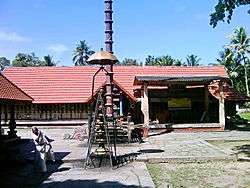
The historical fort of Anchuthengu is about 10 km from Attingal town and the famous Siva temple Avanavanchery Sri Indilayappan Temple is within the Attingal Municipal area.
Transport
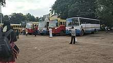
Attingal is one of the important hubs of Thiruvananthapuram district. Kanyakumari-Panvel Highway(National Highway 66 (India)) along with SH 46 and SH 47 connecting the town to Kilimanoor and Nedumangadu, passes through the town.SH46 joins the Town at Alamcode and SH47 at Munumukku. Both KSRTC and private buses have frequent services to nearby towns like Varkala, Kilimanoor, Chirayinkil, Kadakkavoor, Venjarammoodu, Nedumangad, Karette, Vamanapuram, Madathara and to the cities like Trivandrum, Kollam, Ernakulam etc. The nearest railway stations are Chirayinkeezhu Railway station(7 km) and Kadakkavoor Railway station (8 km)and Varkala railway station which is 15 km away. Trivandrum International Airport (33 km) is the nearest airport. Two dedicated bus depots are available in the forms of a Kerala State Road Transport Corporation(KSRTC) bus depot which is one among the 28 Main depots of KSRTC and one Private Bus Terminal, both in the heart of the town.
Notable people
- Prem Nazir, film actor
- Raveendran, music composer
- Jagathy Sreekumar, film actor
- G. Venugopal, playback singer
- Kumaran Asan, poet
- Marthanda Varma, Travancore King
- Bharat Gopy, Film Actor (also producer and director)
- Murali Gopy, Film Actor (also screenwriter, author, singer and former journalist)
Educational institutions
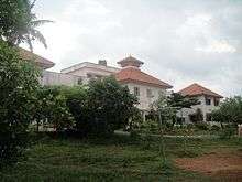
Educational institutions include:
- College of Engineering, Attingal.
- Trivandrum International School, Edackode PO, Korani, Attingal
- Rajadhani Institute of Engineering and Technology, Nagaroor, Attingal
- Govt College Attingal
- Govt Polytechnic college, Valiyakunnu, Attingal
- Govt ITI Attingal
References
| Wikimedia Commons has media related to Attingal. |
- "ആമുഖം". Retrieved 15 July 2018.
- "Census of India: Search Details".
- "Assembly Constituencies - Corresponding Districts and Parliamentary Constituencies" (PDF). Kerala. Election Commission of India. Archived from the original (PDF) on 30 October 2008. Retrieved 21 October 2008.
District HQ: Thiruvananthapuram | |||||||
| History | 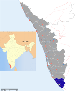 | ||||||
| Geography | |||||||
| Cities and Taluks |
| ||||||
| Transport | |||||||
| Education |
| ||||||
| Buildings | |||||||
| Culture | |||||||
| Lok Sabha constituencies | |||||||
| Sports |
| ||||||
| Museums | |||||||
Govt:ITI(SCDD)EDACODU, KURAKKADA.PO, KORANI, KIZHUVILAM(VIA), ATTINGAL, THIRUVANANTHAPURAM(DIST), PIN CODE:695104