Payyanur
Payyannur is a Taluk in Kannur district of Kerala, India. On 10 March 2018, Kerala Chief Minister Pinarayi Vijayan inaugurated Payyannur as the fifth taluk in the district. This taluk comprises 22 villages including 16 de-linked from the Taliparamba taluk and six from the Kannur taluk.[1] The town is situated on the banks of the Perumba River.
Payyanur | |
|---|---|
Town | |
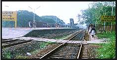 Payyanur Railway Station | |
 Payyanur Location in Kerala, India  Payyanur Payyanur (India) | |
| Coordinates: 12.1076100°N 75.1943590°E | |
| State | Kerala |
| District | Kannur |
| Taluk | Payyanur |
| Government | |
| • Body | Payyannur Municipality |
| Area | |
| • Total | 54.63 km2 (21.09 sq mi) |
| Population (2011) | |
| • Total | 72,111 |
| • Density | 1,300/km2 (3,400/sq mi) |
| Languages | |
| • Official | Malayalam |
| Time zone | UTC+5:30 (IST) |
| PIN | 670307 |
| Telephone code | +91 4985 |
| ISO 3166 code | IN-KL |
| Vehicle registration | KL-83, KL-59 & KL-13 |
| Nearest cities | Taliparamba, Kannur |
| Sex ratio | Male:Female - 46:54 |
| Literacy | 94.08% |
| Lok Sabha constituency | Kasaragod |
Location
Payyanur is located 36 km North of District HQ Kannur, 501 km away from State capital Thiruvananthapuram, 301 km North of Ernakulam, 126 km North of Kozhikode, 56 km South of Kasaragod and 112 km away from Mangalore.
Demographics
According to the 2011 Indian census,[2] Payyannur had a population of 72,111, with males constituting 46% of the population and females 54%. Payyannur has an average literacy rate of 94.08%. This is higher than the national average of 94.00%. Male literacy is 97.02%, and female literacy is 91.60%. In Payyannur, 10% of the population is under 6 years of age.
Etymology
Payyannur derives its name from the renowned Sri Subrahmanya Swami Temple located here. Payyan is an appellation of Lord Subrahmanya and ooru means town or place. Thus Payyannur means the land of Lord Subrahmanya.
Geography
Payyannur is located at coordinates 12.1°N 75.2°E.[3] It has an average elevation of 16 metres (51 feet).
History
Payyannur is one of several extant ancient civilized places in Kerala.[1] The northern town of Kerala claims a rich recorded history. The archaeological remains excavated from Payyannur and nearby places prove the existence of a city in this area centuries ago.[1]
The earliest known mention of this town is in the Brahmanda Purana, when Garga Muni talks about this place to the Pandavas during their exile.[4]
Several notable travelers have described this area in their writings. Ibn Battuta visited Ezhimala in AD 1342 and wrote about the large seaport and the Chinese ships anchored here. Abul Fida in AD 1273, Marco Polo in AD 1293, the Italian explorer Niccolò de' Conti in the 15th century and the Portuguese scholar and traveler Barbosa all visited this place and gave extensive accounts of Ezhimala port, which was then known as "Heli".[1] The scholar and author Hermann Gundert and William Logan, the Malabar District Collector during the British Colonial rule, who wrote Malabar Manual, also visited Payyannur and studied the rich heritage of the area.
Centuries back, Payyannur was a part of the Ezhimala/Mushika/Kolathiri Kingdom. King Nandan was well known as a great warrior and ruler. The books written during the Sangam period describe the area and King. Ezhimala was also under the rule of the Cheras. A famous ruler there was Pazhassi Raja.
Payyannur Pattu, the ballad written by an unknown person belonging to the Chettiar community sometime during the 13th or 14th century, was set here.[5][6]
Evolution of Payyannur
In the past, the city of Kachil Patanam (presently Kavvayi) was the main town due to the proximity of waterways through Kavvayi River and its large seaport. It was both the administrative and business center during that time. According to historians, the ships from China and other countries used to visit this port and were anchored in the nearby river Changoorichal. Kavvayi retained its position during the rule of British East India Company also. They established the first Magistrate's court and Registrar's Office in Kavvayi.
Later, Kokkanisseri became the city center. The main road, which starts from Perumba, divided the town into two. The south of this road was called Payyannur village and the north Kokkanisseri village. The business center was called Kokkanisseri Bazaar. Later, the name Payyannur became common and thus the developed city of today came into existence.
During the regime of the Kolathiri Dynasty, Payyannur was a part of Kolathu Nadu, ruled by the Kolathiri Rajas based in Chirakkal near Kannur. During British rule, Payyannur was considered as a "farka" which in turn is a part of the Chirakkal Taluk. Until the formation of Kerala State in 1957, Payyannur remained in the Malabar District of the Madras State.
Education
Colleges in Payyannur
- Swami Anandatheertha Campus, Payyannur
- Ampere Institute of Engineering and Private ITI.
- Sree Narayana Guru College of Engineering & Technology.
- Payyannur College, Edat.
- Gurudev Arts & Science College, Mathil
- College of Engineering and Technology, Payyannur
- Residential women's polytechnic college Payyannur.
- Government ITI Peringome, Peringome
- Government College, Peringome
- Sree Sankaracharya University of Sanskrit Regional Centre, Payyannur
- AWH- al-badar special college Payyannur. Department of psychology.
Social Service
Orator and freedom fighter KP Kunhirama Poduval, who founded Sanjayan Smaraka Grandhalayam at Annur (Sanjayan Memorial Library), is from here. Kelappan Service Center (perhaps the only institution built in memory of Kelappaji, also known as "Kerala Gandhi") and Payyannur Co-operative Stores are among a number of social organizations in the area.
Culture
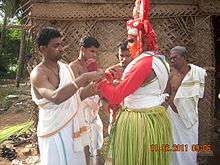
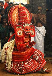
'Theyyam' and religious festivals (Kaliyattam) of various temples attract people to Payyannur. Poorakkali and kolkali are the major traditional dance ritual performances. Architect Kunhimangalam Narayanan, dancer Vannadil Pudiyaveettil Dhananjayan, the Sanskrit scholar E. Sreedharan, are all from the area. The native place of legendary Kathakali master Kalamandalam Krishnan Nair is not far from this town. Kandoth in Payyannur is famous for pottery. The weaver's streets of various villages around Payyannur contribute to the fame of the handlooms of Kannur.
.jpg)
Pavithra Mothiram
Payyannur Pavithram or Pavithra Mothiram is the particular ring worn during performing Vedic or holy rituals or during the "pithrubali" (ceremony performed for the well-being of the forefathers or departed souls) in the Hindu tradition. The traditional Pavitram is usually made of "dharba" grass. The formation of Payyannur Pavitram is closely related to Payyannur Sree Subrahmanya Swami Temple.
Astrology
Payyannur is known for astrology and is home to several eminent astrologers. It has been a hub of astrology for many centuries.[7]
See also
- Annur Sree Mahavishnu Temple
- Kandamkulangara
- Kandankali
- Valiyaparamba Backwaters, 15 km from Payyannur
- Indian Naval Academy, 5 km from Payyannur Railway Station
- Ezhimala, 12 km from Payyannur Town
- Mangalore city, Karnataka.114 km from Payyannur Town
- Kunhimangalam village, 8 km from Payyannur town
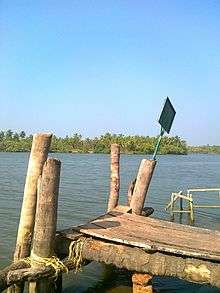
- Kavvayi Island, 3 km from Payyannur
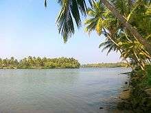 Kavvayi island
 - Payyannur railway station
References
| Wikimedia Commons has media related to Payyanur. |
| Wikivoyage has a travel guide for Payyanur. |
- "Payyanur Informations : Payyanur Municipality Profile". Payyanur, India. Archived from the original on 28 September 2010.
- "District Census Hand Book, Kannur" (PDF). Census Commission of India. Retrieved 31 January 2019.
- Falling Rain Genomics, Inc - Payyanur
- "Subrahmanya". Archived from the original on 27 November 2010. Retrieved 7 February 2010.
- "Payyannur Paattola – Nilakesi's revenge". historicalleys.blogspot.in. Retrieved 7 February 2018.
- "1994 – പയ്യന്നൂർപ്പാട്ട്". ഗ്രന്ഥപ്പുര. 7 February 2018. Retrieved 7 February 2018.
- Srikant (1987). Power in temples : a new look through modern science. Integral Books. p. 84.
| Headquarters | |||||||||||||||||||||||||||||||||||||||||
|---|---|---|---|---|---|---|---|---|---|---|---|---|---|---|---|---|---|---|---|---|---|---|---|---|---|---|---|---|---|---|---|---|---|---|---|---|---|---|---|---|---|
| Railway lines |
| ||||||||||||||||||||||||||||||||||||||||
| Railway stations |
| ||||||||||||||||||||||||||||||||||||||||
| |||||||||||||||||||||||||||||||||||||||||