Uppala
Uppala is a major town in Kasaragod district, Kerala, India. It is a satellite town developing 22 km north to Kasaragod city. Uppala is the one of the fastest growing urban settlements along the National Highway 66. It is well known as a trade hub in the district.
Uppala | |
|---|---|
| Coordinates: 12.683°N 74.9°E | |
| Country | |
| State | Kerala |
| Region | Tulu Nadu |
| District | Kasargod |
| Government | |
| • Body | Taluk headquarters |
| Area | |
| • Total | 25.04 km2 (9.67 sq mi) |
| Elevation | 9 m (30 ft) |
| Population (2011) | |
| • Total | 41,542[1] |
| • Density | 1,650/km2 (4,300/sq mi) |
| language | |
| • Official | Tulu Language, Malayalam |
| Time zone | UTC+5:30 (IST) |
| PIN | 671322 |
| Telephone code | 04998 |
| Vehicle registration | KL-14 |
| Lok Sabha constituency | Kasargod |
| Sex ratio | 1096 ♀/♂ |
| Literacy | 91% |
| Lok Sabha constituency | Kasargod |
| Climate | Tropical monsoon (Köppen-Geiger) |
| Avg. summer temperature | 29.5 °C (85.1 °F) |
| Avg. winter temperature | 26 °C (79 °F) 98 kilometres (61 mi) |
| Precipitation | 3,801 millimetres (149.6 in) |
Location
Uppala is located midway between Kasaragod and Mangalore. It is around 22 km north of Kasaragod and 24 km south of Mangalore . Uppala is located about 586 km north of the state capital, Thiruvananthapuram. National Highway 66, which used to be known as NH 17, passes through the town. Uppala used to be known as Kurchipalla.
According to the census, the town has a population of 41,212 with a population density around 1650 per square kilometre.
Uppala is located near the Arabian sea, and has a very low elevation of nine metres. The town is densely populated near the National Highway 66.
Uppala is a major infrastructural hub in the district and is noted for jewellery shops, fast food restaurants and high residential flats which lie across the town. High rises can be seen in town. It is the major destination for retail shopping in the district. Many projects are active in the town. It is a major business hub in the district and also contributed for the rise in remittance in the state, in the most prevalent sectors like real estate, infrastructure, financial institutions, hospitality and healthcare.
The locals speak many languages such as Malayalam, Urdu and Tulu. It has been selected as the centre of Urdu language in the region.
Uppala is the taluk headquarters of Manjeshwaram Taluk, which was carved out from Kasaragod taluk. Uppala town belongs to Mangalpady Gram panchayat.
Geography
The geographical coordinates of Uppala are: 12° 68' 0" North, 75° 54' 0" East.[2][3]
Uppala lies in the western coast of south India, between the Western ghats and the Arabian sea. Uppala River is also known as Kalai River, originates from the Veerakamba Hills in Karnataka. Uppala river enters Kerala through Manjeshwar thaluk(Uppala) in Kasaragod and finally ends near Uppala Gate. The length of the river is about 50 km. The Uppala River originates at about 150 m height from the sea level. Uppala river constitutes about 50 square kilometres in Kasaragod district. Hence it is the second largest river in the district after Shiriya river (60 km2). Mangalpady river, which flows in kukkar, is another river in Uppala.
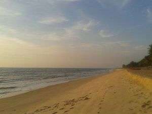
Uppala's beaches include Uppala Beach, Moosodi Beach and fishing zone, Ayyoor-Parakkatta Beach, Ayyoor-Peringady beach and Berika Beach.
Uppala is the neighbouring town for Kumbla, Manjeshwar, Paivalike, Puttur, Vittal, Kasaragod and Mangalore.
As of the 2011 Census, Uppala has a total area of 25.04 km2 and a population around 41,000, which is densely located on the sides of NH 66.
Suburbs of the town include Cherugoli (Mangalpady), Deenar Nagar, Uppala Gate, Hanafi Bazar, Nayabazar, Moosodi, Kondevoor, Kodibail, Songal, Kodanga, Pathwadi,Baliyoor,Mulinja, Mannamkuzhi, Bappaithotti, Hanuman nagar, Manimunda, Kukkar, Kaikamba (Bombay Bazar), Turti, Bhagavathi, Kuntupuni, vikram bazar, Hidayath Bazar, Hidayath Nagar, Pachilampara, Kuntupuni, Hajimalang Road, Bekoor, Kubanoor, Kedakkar and Aila.
Railway station
Uppala has a railway station of Indian Railway, built while during British India. It is historically important because of its design of construction and structure. It lies between Kumbla and Manjeshwaram railway station (10 km).
The railway station does not have basic infrastructure facilities like seating, multiple platforms, multiple tracks, better signal facilities, pure drinking water, waste management, taxi service, better language service, rest rooms, security force, complaint service, canteen, shops, better toilets (sanitation) etc.
The station's main problem is lack of train service (train stop). Only few trains stop at Uppala railway station, and express trains do not here. This affects thousands of passengers who travel to Mangalore and Cannannore side.
Climate
Uppala has a tropical climate. In most months, it receives significant rainfall. There is only a short dry season and it is not very effective. The Köppen-Geiger climate classification is Am. The average annual temperature in Uppala is 27.1 °C. About 3801 mm of precipitation falls annually.
The driest month is January, with 1 mm of precipitation. Most precipitation falls in July, with an average of 1178 mm.
The warmest month of the year is April, with an average temperature of 29.2 °C. In July, the average temperature is 25.9 °C. This is the lowest average temperature of the year.
The difference in precipitation between the driest month and the wettest month is 1177 mm. The average temperatures vary during the year by 3.3 °C.
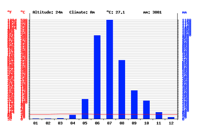 Climate graph of Uppala |
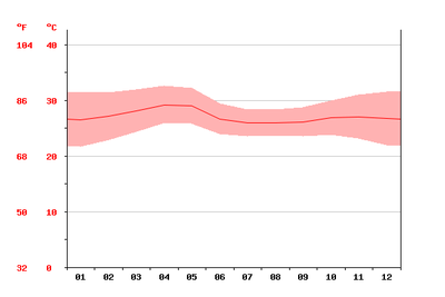 Temperature graph of Uppala |
| Climate data for Uppala, India | |||||||||||||
|---|---|---|---|---|---|---|---|---|---|---|---|---|---|
| Month | Jan | Feb | Mar | Apr | May | Jun | Jul | Aug | Sep | Oct | Nov | Dec | Year |
| Average high °C (°F) | 31 (88) |
31 (88) |
32 (90) |
33 (91) |
32 (90) |
29 (84) |
28 (82) |
28 (82) |
29 (84) |
30 (86) |
31 (88) |
32 (90) |
33 (91) |
| Average low °C (°F) | 22 (72) |
23 (73) |
24 (75) |
26 (79) |
26 (79) |
24 (75) |
24 (75) |
24 (75) |
24 (75) |
24 (75) |
23 (73) |
22 (72) |
22 (72) |
| Average rainfall mm (inches) | 1 (0.0) |
1 (0.0) |
4 (0.2) |
46 (1.8) |
234 (9.2) |
992 (39.1) |
1,178 (46.4) |
698 (27.5) |
337 (13.3) |
215 (8.5) |
76 (3.0) |
19 (0.7) |
3,801 (149.6) |
| Average rainy days (≥ 0.1 mm) | 0 | 0 | 1 | 3 | 10 | 26 | 30 | 26 | 20 | 13 | 6 | 1 | 136 |
| Average relative humidity (%) | 62 | 66 | 68 | 71 | 71 | 87 | 89 | 88 | 85 | 79 | 73 | 65 | 75 |
| Source: climatedata.org[4] | |||||||||||||
Demographics
Religions in Uppala town
source:http://www.census2011.co.in/data/town/627125-uppala-kerala.html
As of the 2011 census, the total population of Uppala is 41,212, 17,093 of whom are male and 18,728 of whom are female. The town has an area of 23.04 square kilometers and a population density of about 1,650 people per square kilometer. It has a literacy rate around 91 percent and a population of 5,743 children below six years. Hence 14 percentage of the total population are of below 6 years age. There is a steady growth in the town population in the past few years.
People in Uppala speak many languages including Malayalam, Tulu, Kannada and Urdu.
Civic administration
Uppala is a taluk headquarters of Manjeshwaram Taluk, Kasaragod. The taluk office is at Main Junction, Uppala. Other government institutes in Uppala are Village office, which is in Nayabazar, Mangalpady Panchayath office at Nayabazar, Fire and Rescue station at Ambar, Community Health Center at Nayabazar, AEO'S Office, Uppala Post office, Mangalpady Post Office, Krishi Bhavan at Ambar and veterinary hospital at Ambar.
Uppala also has K.S.E.B. on Pathwadi road, Kerala Water Authority Pump House at Cherugoli, cultural centre and library at Nayabazar, Lion's Club at Nayabazar, and Govt Kerosene Supply bunk at Ambar.
Transportation
Air
The nearest airport to Uppala is Mangalore International Airport, which is around 37 km away from the town. Kannur International Airport, which is 143 km from the town . Other airports near Uppala are Calicut International Airport, about 225 km to the south; and Mysore Airport, around 255 km to the south east.
Road
Uppala is situated on NH-66. It has a bus station and has a minute to minute bus facility to Kasaragod and Mangalore. Uppala is well connected by road to Mangalore, Udupi, Manipal, Puttur, Kasaragod, Kannur, Calicut, Kochi and Thiruvananthapuram.
Uppala-Bayar road connects Uppala with Paivalike, Bayar and leads to Kanyana, Vittal and Puttur in Dakshina Kannada district, Karnataka. Uppala bus station also provides buses to Puttur via Paivalike, Uppala to Badiyadka, Heroor and many other places. Buses which moves from Mangalore to Thiruvananthapuram stops in Uppala Bus Station. There are both private and government buses. Taxi facilities are available in the town. There are a few auto sheds in the town, which have autorickshaws.
Rail
Uppala has a railway station, west from the heart of the town, where both the passenger and express trains stop. Most of the students and workers travels daily by train to Mangalore from Uppala. Uppala is connected to Mangalore, Kasaragod, Kanhangad, Kannur,Kottayam, Thrissur, Ernakulam, Trivandrum, Coimbatore, and many other towns and cities by railway.
Sea
New Mangalore Port is the nearest seaport to Uppala, which is around 33 km to the north. The State Government have planned to construct a port capable of 275 boats in Moosodi near Manjeshwar.
Economy
Uppala is the destination for a hundred thousand shoppers in the district. The shop category mainly includes fashion, jewellery, food, and automobile.
Uppala has many private education centres, and it is the education hub for a population of 50,000.
Uppala is also home to many national level builders, but the town lacks the basic infrastructure like four laned road, proper two laned road connectivity with neighbouring places, footpaths, a better railway station or municipality status due to lack of educated government leaders.
Education and health
Hospitals
Uppala has small and old government hospital at Nayabazar. Small private hospitals like KNH Hospital at Uppala railway station road and Health Care Center has got underwhelming health infrastructure and cleanliness for present standards. Hence the people in town are forced to travel to nearby towns and cities for medical purposes, which are not in less than 20 KM radius of Uppala.
Sports
The residents of Uppala play 2 major sports, Football and cricket. There are 2 major clubs in uppala namely "Citizen sports club" and "Manamkuzhi sports club. Citizen sports club is one of the oldest and well known football club in Kerala which has won many trophies and tournaments all over Kerala. Manamkuzhi sports club is also one of the oldest and well known cricket club in Kerala. The main focus of this club is to promote cricket.
Schools and education
This town also has one of the finest education centres in the district. These centres serves education for more than 20,000 students in the region. Most students here do 10th grade from these centres and favour colleges in Mangalore for their higher education.
The syllabus offered in these centres until the high school includes Kerala State Syllabus and C.B.S.E. The town also witnesses many 3rd grade colleges offering degrees.
One of the oldest schools founded in the 1980s, the Ayyoor Jamath Islami (A.J.I.) School by Late Umar Moulavi, who with the help of his well wishers endeavored to build the school at that time, has become one of the main and important educational institutions in this region. Another school is Aji Senior Secondary School.
- Manjeshwaram Taluk Hospital
- Manjeshwaram RTO
- Uppala Police Station
- Manjeshwaram Muscif Court
- Manjeshwaram Ist Class Magistrate court
Utility services
Electricity in Uppala is regulated by the Kerala State Electricity Board (KSEB).
Only prominent broadband internet service provider in the town is BSNL.
See also
References
- List of Cities and Towns in Kasaragod district
- Uppala Map — Satellite Images of Uppala
- "Geography data of Uppala". US Military Intelligence Agency.
- "Climate data of Uppala".
External links
| Wikimedia Commons has media related to Uppala. |