Kumily
Kumily (also spelt as Kumaly) is the largest Gram Panchayat in the Idukki district of Kerala. It is a town in Cardamom Hills near Thekkady and Periyar Tiger Reserve. Kumily is gateway town in Kerala to Tamil Nadu.
Kumily (குமுளி) Kumali (കുമിളി) | |
|---|---|
Plantation Town | |
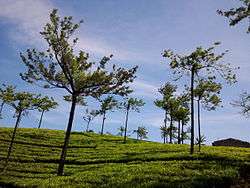 Tea plantations at Kumily | |
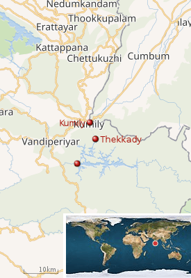
 Kumily (குமுளி) Location in Kerala, India  Kumily (குமுளி) Kumily (குமுளி) (India) | |
| Coordinates: 9°37′0″N 77°9′0″E | |
| Country | |
| State | Kerala |
| District | Idukki |
| Zone | Idukki |
| Named for | Thekkady tourist spot |
| Area | |
| • Total | 816.73 km2 (315.34 sq mi) |
| Elevation | 880 m (2,890 ft) |
| Population (2001) | |
| • Total | 33,722 |
| • Density | 412/km2 (1,070/sq mi) |
| Languages | |
| • Official | Malayalam, Tamil, English |
| Time zone | UTC+5:30 (IST) |
| PIN | 685509 |
| Area code(s) | 04869 |
| Nearest Town / city | Nedumkandam, Theni, Munnar, |
| Lok Sabha constituency | Idukki |
 |
History
The present-day Kumily has roots in the colonial period of British. The area was once owned by the Thekkumkoor rajas in central Travancore and later when Marthanda Varma conducted his campaigns in central Travancore, regions including Kumily came under Travancore kingdom. Till the end of the 19th century, the area was given under control of Poonjar kings. But the drastic and significant changes occurred in the region by the advent of British powers. They obtained these regions from the local rulers and transformed the forestlands into cultivatable one. Large-scale production of cash crops like cardamom, pepper, coffee, cinnamon etc. were begun in the hilly terrains. Many people from in and outside Kerala were brought to work in these plantations.[1]
Topography
Kumily lies in the southeastern part of Idukki district at an altitude ranging from 2,890 ft (880 m) from mean sea level. A sizeable portion of the land is covered by vast cardamon plantations and parts of land in the south and southeast portion are under the premises of Periyar Wildlife Sanctuary which are thick forests.
Transportation
Kumily lies in the NH-183 (previously NH-220) that connects Kollam to Dindigul in Tamil Nadu via Kottayam, Mundakkayam, Kuttikkanam. The state of Tamil Nadu borders the town. It is a major tourist destination and a spices trading centre. The nearest airport is Madurai (145 km) and railway Station is Theni. The famous pilgrim centre Sabarimala is 105 km from Kumily. Kumily is well connected by Kottayam through KK road passing through Vandiperiyar, Pambanar, Mundakayam, Kanjirappally, Ponkunnam, Pampady, Manarkadu.
Kochi can be reached by using KK road up to Ponkunnam and deviate to Pala, Kaduthuruthy, Thalayolaparampu, Thripunithura, and Vytilla.
Angamaly can reached by Mundakayam, Kanjirappally, Ponkunnam, Pala, Thodupuzha, Muvattupuzha, Perumbavoor, and Kalady.
Tourism
Kumily is always a special destination for most of the tourists due to its cool refreshing climate. Nearby Tamil Nadu district is Theni, where tourists can see grapes cultivations, Suruli Theertham, Megamalai, Kumabakarai, Vaigai dam etc. Kattappana is the nearby municipality. Famous tourist attractions nearby are Thekkady, Anchuruli (near Kattappana), Ottakathalamedu, Kalvery Mount, Wagamon, Pine forest, Kalyanathandu etc.
Gallery
 An elephant used for safari in Thekkady
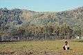 Kumily is a photographer's paradise
 View from Kumily
References
- "History, Kumily panchayat- details, Periyar, Thekkady, Idukki, Kerala - www.keralatourism.org › periyar". www.keralatourism.org. Retrieved 7 December 2016.
| Wikimedia Commons has media related to Kumily. |
| Wikivoyage has a travel guide for Kumily. |