Peravoor
Peravoor is a town in Kannur district of Kerala state in India. It is east of Kannur (54 km) and Thalassery (44 km). And Iritty, the nearest municipality, is 15 km to the north of Peravoor.[1] Peravoor is situated in the Western Ghats mountain range.
Peravoor | |
|---|---|
Village | |
 Peravoor-: 'Thalassery-Iritty-Kottiyoor' Junction | |
| Coordinates: 11.900066°N 75.731979°E | |
| Country | |
| State | Kerala |
| District | Kannur |
| Government | |
| • Type | Local self government |
| • Body | Grama Panchayat |
| Area | |
| • Total | 34.1 km2 (13.2 sq mi) |
| Population (2011) | |
| • Total | 20,618 |
| • Density | 600/km2 (1,600/sq mi) |
| Languages | |
| • Official | Malayalam, English |
| Time zone | UTC+5:30 (IST) |
| PIN | 670673 |
| Telephone code | 0490 |
| ISO 3166 code | IN-KL |
| Vehicle registration | KL 13 (Kannur), KL 58 (Thalassery),KL 59 (Thaliparamba), KL 78 (Iritty) |
| Nearest city | Iritty |
| Lok Sabha constituency | Kannur |
Introduction
History of Peravoor is related to Pazhassi Raja, a warrior prince and de facto head of the kingdom of Kottayam and one of the earliest freedom fighters of India. There are many remnants of Pazhassi Raja's hiding places in and around of Peravoor.
St. Joseph's Forane Church in Peravoor is the first Syro-Malabar Catholic Church in Malabar, formed under the Thalassery Archdiocese[2] Peravoor is near the Kottiyoor Shiva temple and Sree Mridanga Saileswari Kshethram.[3]
It is the first place where the Syro-Malabar Christian (Nazrani / Saint Thomas Christians) migrants from Central-South Kerala occupied during the Malabar migration. This community contributed to the fields of education, sports, culture and many more basic developments of Peravoor and its vicinity.
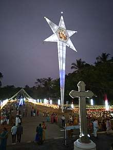
Peravoor holds the Guinness World Record for the Tallest Christmas Star in the World.
Government and private institutions include hospitals, schools, clubs, churches, a police station, a fire station, theatres, banks, a treasury, and shopping malls.
Famous persons from Peravoor
- Jimmy George (born 8 March 1955 at Peravoor, died 30 November at Italy, 1987) was a professional volleyball player from Peravoor. He is being considered as the legend of volleyball. He was the first Indian volleyball player to become a professional, and played for Italy and Abu Dhabi.
- Tintu Luka (born 26 April 1989) is an Indian track and field athlete, who predominantly competes in the middle-distance running events. Born in Valathode, Kerala, she is the national record holder in the women's 800 metres. Luka represented India at the 2012 and 2016 Summer Olympics. In addition to being the 2015 Asian Champion in the 800 meters, she has won a total of six medals at the Asian Athletics Championships.
Transportation
The national highway passes through Kannur town. Mangalore and Mumbai can be accessed on the northern side and Cochin and Thiruvananthapuram can be accessed on the southern side. The road to the east of Iritty connects to Mysore and Bangalore. The nearest railway station is Thalassery on Mangalore-Palakkad line. Kannur International Airport is just 27 km away from Peravoor. There are airports at Mangalore and Calicut.
Wayand is just 30 km away from Peravoor. Wayand can be accessed through Peravoor-Nidumpoil-Mananthavadi road (Baveli Road) or Peravoor-Kottiyoor-Mananthavady road. There are several bypass roads available such as the Peravoor-Poolakutty[4]-Mananthvady road which was used by Pazhassi Raja, British people and Tippu Sultan.
Distances to some of the important places:
Hospitals
- Archana Hospital
- Syrus Hospital
- Peravoor Thaluq Hospital
- Resmi Hospital
- Dr:Vasudevan'sHospital
- Dr:Bhaskaran's Hospital
- Ann Hospital
- many Homeopathic, Ayurvedic and Dental hospitals and clinics
Tourism
Peravoor and the surrounding areas have many tourist attractions.
- Aralam Wildlife Sanctuary
- Pazhassi Dam and garden
- Kanjirakkolly waterfalls
- Perumparamba Mahatma Gandhi Park
- Coorg valleys
- Palchuram
- Krishnagiri river and Barapole hydroelectric project
- Central State farm at Aralam
- Steel Girder Bridge at Iritty built by British
- Madikeri
- Wayanad
- Wayand Ghat Roads
- Elappeedika
Hotels and Lodging
There are many restaurants, hotels and bars in and around the city.
References
- "Perevoor Panchayath". Perevoor Panchayath. Retrieved 30 January 2019.
- Thalassery Archdiocese
- http://mridangasaileswaritemple.org/
- Poolakutty
| Wikimedia Commons has media related to Peravoor. |