Muvattupuzha
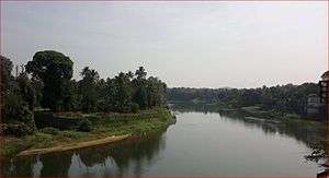
Muvattupuzha is a prominent old town in the midlands directly to the east of Kochi in Ernakulam district, Kerala. It is situated at around 36 km (22 mi) from downtown Kochi. The town is a growing urban centre in central Kerala.[1] The town is also popular as the starting point of Muvattupuzha river which happens by the merging of three rivers – namely Thodupuzhayar (Thodupuzha river), Kaliyar (Kali river) and Kothayar (Kothamangalam river) – to form Muvattupuzhayaar. Thus, this Thriveni Sangamam or confluence of three rivers is called Muvattupuzha.
Muvattupuzha | |
|---|---|
Municipal Big Town | |
 Muvattupuzha Old and New Bridges | |
| Nickname(s): മുവാറ്റുഴ, മുവാറ്റ്ഷ, മുവാറ്റ്ഴ | |
| Country | |
| State | Kerala |
| District | Ernakulam |
| Government | |
| • Type | Municipality |
| • Municipal Chairperson | Usha Sasidharan |
| Area | |
| • Total | 13.18 km2 (5.09 sq mi) |
| Elevation | 15 m (49 ft) |
| Population (2011) | |
| • Total | 61,770 |
| • Density | 2,306.3/km2 (5,973/sq mi) |
| Languages | |
| • Official | Malayalam, English |
| Time zone | UTC+5:30 (IST) |
| PIN | 686661(kacherithazham), 686673(vellorkunam), 686662, 63, 64, 65, 66, 67, 68, 69, 70, 71, 72, 682316, 682308 |
| Telephone code | 0485 |
| Vehicle registration | KL-17 |
| Nearest city | Kochi, Kottayam |
| Sex ratio | 1023 ♂/♀ |
| Legislative assembly constituency | Muvattupuzha |
| Climate | Tropical monsoon (Köppen) |
| Avg. summer temperature | 32.5 °C (90.5 °F) |
| Avg. winter temperature | 20 °C (68 °F) |
| The town where three rivers merge to form Muvattupuzha river. | |
.jpg)
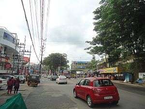
Muvattupuzha is a municipality in the eastern side of Ernakulam district in the Indian state of Kerala. The town is bordered by Kottayam district on southern side and Idukki district on eastern side approximately 20 km from the town. Muvattupuzha lies on the intersection between M C Road and National Highway 49, about 42 km from district capital Ernakulam.Muvattupuzha is located 20 km from Thodupuzha, 17 km from koothattukulam and 5 km away from Arakuzha. It is the second biggest commercial centre of the district and one of the biggest in the central part of the state.
Etymology
The town is named after the Muvattupuzha river which flows through it. The name is made up of three Malayalam words: Moonnu, which stands for three; aaru, small river; and puzha, which also means river. Aaru is a word that is usually used for rivers in the southern half of Kerala, while the term puzha is used in the northern parts. The three rivers in this case are the Kothamangalam river or Kothayaar, Kaliyar and Thodupuzhayar, which merge to form a single river called Muvattupuzhayar. This place is called Thriveni Sangamam in Malayalam which means the point of confluence of three rivers.
In English both spellings viz. Muvattupuzha and Moovattupuzha are interchangeably used. Etymologically Moovattupuzha, is the correct spelling how ever commoners widely use the spelling Muvattupuzha and is better accepted.
History
Muvattupuzha was part of the Vadakkumkoor[2] Kingdom until it was captured by the Travancore Kingdom. Old documents show that parts of the lands of Muvattupuzha belonged to Edappally Swaroopam, but were later transferred to Manas' (Brahmin Families).[3]
After Indian Independence, from 1949 to 1956, Muvattupuzha was a part of the Kottayam district in Travancore-Cochin state.[4] In 1956, when Kerala state was formed, Muvattupuzha remained as a part of Kottayam district until 1958, when Ernakulam district was formed on 1 April 1958.[5] Muvattupuzha, as a village union, came under the control of a council of three members nominated by the Government. V. P. Govindan Nair was the first president of the village union. By 1953, Muvattupuzha was declared a Panchayat. Kunnappillil Varkey Vaidyan was the first president of the elected Panchayat Committee. Muvattupuzha was raised to the status of a Municipality in the year 1958. N. Parameshwaran Nair became the first Municipal Chairman. Muvattupuzha made history as the first Municipality where the Communist Party came to power in a general election.
N. P. Varghese was the first elected M.L.A. from Muvattupuzha Assembly Constituency. He defeated Manjunatha Prabhu of Communist party.[6] Later, K. M. George, founder of Kerala Congress represented Muvattupuzha. The first M.P. of Muvattupuzha (Lok Sabha constituency) was George Thomas Kottukapally. Of all the Municipal Chairmen of the town, P. P. Esthose deserves special mention. He was simultaneously an MLA and the Municipal Chairman of Muvattupuzha. He got state-level recognition as the Chairman of Chamber of Chairmen. In its entire history, he is the only Communist member elected to the Parliament from the constituency. The first Block Panchayath President of Muvattupuzha was Adv.Shyson P Manguzha (Kerala Congress) in 1995 From Arakuzha block panchayth division.
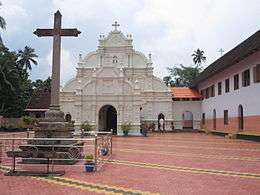
St. Thomas, the Apostle of Jesus Christ who introduced Christianity to India, is believed to have visited this region. The Marth Mariam Syro-Malabar Catholic Church of Arakuzha has a recorded history of over 1000 years, making it one of the oldest Syrian churches in Kerala.[7][8] It is known for its paintings and sculptures. Muvattupuzha was also known as Arakuzha Pakuthi (meaning half of Arakuzha).
Demographics
As of 2001 India census,[9] Muvattupuzha had a population of 29,230. Males constitute 49% of the population and females 51%. Muvattupuzha has an average literacy rate of 84%, higher than the national average of 59.5%: male literacy is 85%, and female literacy is 82%. In Muvattupuzha, 11% of the population is under 6 years of age.
Malayalam and English are the official Languages. Tamil is also widely understood. Hindi is widely spoken and understood due to the influx of migrant labours from North India.
Religion
The region has Hindus, Syrian Christians and Muslims.
According to the 2011 census, Hindus consist of 39.91% Muslim consist of 38.82% and Christianity 21.10% of the total population.
Kavumpady Road in the heart of the town contains major Agraharam of Kerala Iyers. Konkanis are also in lesser numbers. Hindus are majority in the region with castes like Nair, Ezhava, Namboodiri, and Pulayar present around the Taluka.
Syrian Christians include a majority of Syro-Malabar Catholics and Jacobites. There are Orthodox, Syro-Malankara Catholics, Marthomites and Evangelists also. Muvattupuzha is the seat of Muvattupuzha diocese of Malankara Jacobite Syriac Orthodox Church and Kandanad East diocese of Orthodox.
Mappila Muslims make up most of the Muslim population. Hanafi sect called Thulukkar are concentrated around Pettah, near Post office Junction. Muslims include Sunni, Ahmediyya.
Geography
The town and western parts of the region are mainly plains and is culturally similar to Ernakulam whereas the eastern parts are mainly highlands and differ from the western parts as most of the region are agricultural areas.[10] Essentially, the regions of Thodupuzha, Muvattupuzha and Kothamangalam were called sub-high range[11] or Keezhmalanad[12] of erstwhile Vadakkumkoor Kingdom[13] indicating these as lands with fertile soils deposited by Thodupuzha and Muvattupuzha rivers over a period of time due to floodings of the banks. While, Muvattupuzha and nearby areas are less hilly and fertile. The altitude is much lesser and the hilly region is the Kadalikkad-Meenkunnam-Pampakkuda curved region. Muvattupuzha, thus have vast flat lands and paddy fields spread even up to 30 km to the east till Vannappuram. The town is 20m above mean sea level (MSL).
The term sub-highranges or "low ranges" is a subtle term used to indicate the towns of Thodupuzha and Palai. In fact, the low ranges towns lying in the foothills of Western ghats all along the SH 8 (Punaloor-Muvattupuzha road) meet the main interjunction at Muvattupuzha, which is the most strategically connected and accessible place in central Kerala. A total of 9 important roads meets here connecting to all directions.
Politics
Muvattupuzha is one of the 140 legislative assembly constituencies of Kerala state. Muvattupuzha assembly constituency is part of Idukki (Lok Sabha constituency) and the current MP is Dean Kuriakose of Indian National Congress.[14] Previously it was a part of Muvattupuzha (Lok Sabha constituency). The major political parties of Muvattupuzha are Indian National Congress,Kerala Congress (M),CPI (M),CPI,Muslim League, and B.J.P. Eldho Abraham of CPI is the MLA of Muvattupuzha at present.
Administratively, Muvattupuzha is a municipality and the current municipal council is ruled by Communist Party of India (Marxist), led by Usha Sasidharan who was elected in 2015.[15]
Eminent political leaders of the past include K. M. George (former Minister and the founder of Kerala Congress) and P.P Esthose (Former M.P and M.L.A ). The present political leaders of Kerala who are from Muvattupuzha are Johny Nelloor, former M.L.A and Chairman of Kerala Congress Jacob faction and Chairman of Oushadhi and Francis George (Former M.P), Gopi Kottamurikkal (Former M.L.A and Ernakulam district secretary of CPI(M)).
Muvattupuzha river
The Muvattupuzha river (Malayalam: മൂവാറ്റുപുഴയാർ) which starts in the Idukki highranges and flows through Muvattupuzha town runs for 121 km and enters the Kottayam district. The major source of water is the Thodupuzha river which starts in the Idukki district and provides water throughout the year, enabled by the supply of water from Idukki arch dam. Idukki dam is the largest arch dam in India and it is used for hydro-electric power generation.[16] This is an old heritage route all along the river's path up to Vaikom. Old settlements along the path of the Muvattupuzha river evolved into towns. These include Muvattupuzha, Vaikom, Thodupuzha, Piravom, Thalayolparambu etc. 70 or 80 years back, transportation was essentially through Kettuvallam (House boats) traveling to Vettikkattumukku and Vaikom to reach Alappuzha and through Poothotta to reach Kochi. Before Kothamangalam and Thodupuzha evolved as prominent hill produce market, Muvattupuzha was the old centre owing to the connectivity through the river which was of prime importance in the yesteryears, when road transportation was in the infant stage. Muvattupuzha river is the prime victim of river pollution nowadays.[17] Green People, an environmental organization is now leading a campaign to save the Muvattupuzha river. Companies like Hindusthan Newsprint Limited functions near the banks of this river but this company was having advanced effluent treatment system but these days this system is not functioning as per expectation and the river water turns black where effluent joins river at pipeline junction.
Muvattupuzha Bridge
It was in 1914 when M Krishnan Nair was the Resident Diwan of Travancore, the first concrete bridge in Asia[18] was built in Muvattupuzha under the supervision of the British engineer W.H. Emrald. It is said that on its inauguration, to convince the strength & stability of the bridge, Emrald and his wife sat beneath the bridge in a boat while 15 elephants walked over it.[18] This bridge is across the Muvattupuzha river connecting Nehru Park and Kacherithazham.
There was a wooden bridge across the river through which the steam bus(കൽക്കരി വണ്ടി/കരിഗ്യാസ് വണ്ടി ) goes from Muvattupuzha to Ernakulam in olden days. The border to Cochin state was at Chungam, Mamala, near Thiruvankulam. Until the late 1970s, traffic was through the old concrete bridge. There was a traffic police outpost on either side of the bridge to control one way traffic at a time through the narrow bridge. Later in the 1970s, a new bridge was constructed and in the late 1970s the traffic diverted through this wider two way bridge.
Folklore
Kadamattathu Kathanar was a magician in this region who travelled Kerala to immobilize Yakshis (female demons).[19]
Theevettikkolla (തീവെട്ടിക്കൊള്ള) is a term that originated from Muvattupuzha.
Suburbs
In the olden days, there was a petrol pump in BOC junction. BOC is the short form for [Burmahshell Oil Company]. Later it is said that Jawaharlal Nehru addressed people in this junction(1958) and now called Nehru Park after his name. Muvattupuzha along with Aluva were the populated towns prior to the 1960s and hold huge importance. Petrol bunks, automobile workshops, electricity were available in Muvattupuzha much earlier than the neighbouring regions.
The town consists of two regions separated by the Muvattupuzha bridge. Kacherithazham is the main centre of the town to the east of the Muvattupuzha bridge. Nehru Park, Velloorkunnam and Vazhappilly are to the north of the bridge. TB.Junction and P.O Junction lies East of the bridge. Kavumkara is an old market which lies to the northeast of the town after the bridge on the Muvattupuzha–Kothamangalam road.
Latha bridge or Thodupuzha bridge is over the Thodupuzha river, which flows through the southeast portions of the town before merging with Muvattupuzha river near Kacherithazham. Kizhakkekara and Randaattinkara (Randarkara or Randar) lies on the eastern part of the town on the banks of the Muvattupuzha river. From the olden times, south of Marady (മാറാടി) panchayat towards Kottayam were sparsely occupied and still has old rubber plantations and a hilly terrain until Koothattukulam. Aaroor (ആറൂര്) (near Meenkunnam) was a forest before 5–6 decades. While every direction from Muvattupuzha is populated and almost urbanized, the southern direction towards Kottayam via M C Road is not so developed in terms of infrastructure. At a distance approximately 8 km southwards, Muvattupuzha town is covered by a curve-like hilly region of 40–60 MSL in the whole southern side which crosses Kottayam and Piravom routes. Most of these hills are rubber plantations.[20] KSTP's second phase project of straightening of the Muvattupuzha – Chengannur MC Road is recently inaugurated.
The old Muvattupuzha bridge built over the Muvattupuzha river was the first concrete bridge in Asia. It was completed in 1914.[21] This serves as the connection between Nehru Park and Kacherithazham.
The nearby panchayaths are mostly into agriculture, small- and medium-scale industries. Pineapple and rubber plantations are the common agrarian efforts. Match box industries, plywood factories, saw mills, paper, plastic and wood carton making are the main industries in this area. KINFRA's Small Industries Park at Nellad is 9 km from Muvattupuzha on SH41.[22]
Nearby towns
The nearby main towns are Kothamangalam, Thodupuzha, Piravom, Koothattukulam, Perumbavoor. There are many small suburban towns close to Muvattupuzha like Kolenchery, Vazhakulam, Kalloorkkad, Pothanicad, Nellikuzhy, Nellad etc.
| |||||||||||||
Culture
Muvattupuzha has a rich cultural tradition. Margamkali and martial arts like Parichamuttukali, are popular among the Syrian Christian community. It is performed by men and women separately during Syrian Christian weddings. Shadkala Govinda Marar was born on the banks of the Muvattupuzha river at Ramamangalam. In the new era, Mela (Muvattupuzha Enlightened Lovers of Arts) – a registered fine arts society which was established in 1968 plays the lead role in the cultural life of this town.
Notable people
- Madhu Neelakandan, Award Winning Indian Cinematographer
- K. M. George was a veteran politician and former Minister. He was the founder of the Kerala Congress Party and former Muvattupuzha M. L. A. His son Francis George is former M. P. of Idukki.
- Johnny Nellore is a veteran politician and former M.L.A of Muvattupuzha from 1991 to 2006. He is the chairman of Kerala Congress (Jacob).
- Francis George is a Kerala Congress leader and former M.P. of Idukki. He is the son of K. M. George.
- Prof M P Manmadhan (Retired Principal M G College, Trivandrum) who popularised Kadhaprasangam in Kerala and acted in film Vigatha Kumaran (1955)
- Jeethu Joseph, Award Winning Indian film director and screenwriter
- Bhagath Manuel, Indian film actor.
- Vishak Nair, Indian film actor
- Anoop Kannan, Indian film Director & Producer
- Kalabhavan Abi, Indian film actor
- Shane Nigam,Indian Film Actor, son of Actor Kalabhavan Abi
- Mannathoor Willson, Writer of novel ''Meghangalil Moothramozhikkunnavan"
- October Rathriyude Maranam. He is also a government employee
- D. Sreeman Namboothiri . He was a scholar and a mature poet.
- P.P. Esthose, Ex. M.P
- Amni Shivaram, the first Malayali woman journalist[23]
Places of worship

- Velloorkunnam Shiva Temple
- Puzhakkarakavu Bhagavati Temple
- Chakkunnathu Sree Mahadeva Temple
- Sree Kumara Bhajana Devaswom Temple
- Pallikavu Bhagavati Temple
- Mattapili Sri. Krishna Temple
- Sivankunnu Temple
- St. Mary's Jacobite Syrian Church, East Vazhappilly
- Ramakrishna Math
- Kizhakkekara Sri Dharma Sastha Temple
- Nettorkottu Vanadurga Devi Temple
- Kadamattom Church
- Marth Mariam Syro-Malabar Catholic Forane Church
- Marth Mariam Syro-Malabar Catholic Forane Church[24]
- Holy Magi Syro-Malabar Catholic Forane Church
- Holy Magi Syro-Malabar Catholic Forane Church, a St. Joseph's Syro-Malankara Catholic Cathedral
- Christ the King Roman Latin Church
- Mappila Muslims following Shafi'i Fiqh are the majority in Muvattupuzha, Kothamangalam Talukas. the main Masjid is Central Mahallu Jama'ath[25] situated at Kavumkara market.
- Perumattom Dasukhi Masjid is one of the oldest one. Valiyuppappa, a Sufi Darvesh famous for his treatments and mystical capabilities lived in Perumattom. Mappila Muslims of this region considers Perumattom as the main centre from where many of them migrated to Nellikkuzhy, Kothamangalam and parts of Idukki.
- Petta Juma Masjid in Pettah, near Post office Junction, Muvattupuzha is the main mosque of Thulukkar or Tamil Muslims who follow Hanafi Fiqh.
- Ahmediyya Mosque is situated in Vazhappilly towards Pattimattom route.
Educational organizations
- Viswajyothi College of Engineering and Technology, Vazhakulam
- St. Sebastines Higher Secondary School
- Presidency International School
- Vimalagiri International School
- TTVHSS <http://tharbiyath.org/>
- Ilahia College of Engineering and Technology[26]
- Ilahia College of Arts & Science, Pezhakkappilly
- Ilahia School of Science and Technology, Pezhakkappilly
- Govt Higher Secondary School, Pezhakkappilly
- Arafa Public School, Pezhakkappilly
- Arafa College of Arts & Science, Pezhakkappilly
- Ilahia Public School
- KMLPS LP School
- Annoor Dental College, Perumatom
- MES Punnamattom
- Nirmala College <http://www.nirmalacollege.ac.in/>
- Nirmala College of Pharmacy <http://www.nirmalacp.org>
- Nirmala Public School <http://nirmalapbs.org>
- Nirmala Higher Secondary School
- St. Augustines Girls Higher Secondary School
- St. Thomas Public School
- Vimalagiri International School
- Presidency Central School
- SNDP Higher Secondary School
- Sivakunn Higher Secondary School
- Govt. Model Vocational Higher Secondary School
- MIET High School
- TMA Public School
Sports
Football
Football is a very prominent game in the Muvattupuzha-Kothamangalam area. Unlike most nearby places, where you find shuttle badminton, volleyball and cricket playing as common gaming activities, Muvattupuzha and nearby regions always has Football as popular gaming choice. Grounds are active with various football teams coming from various villages and towns of Muvattupuzha-Kothamangalam-Kolenchery area. Muvattupuzha FC is the only Kerala Football Association affiliated football club in Muvattupuzha taluk. It was founded by Mr.Eldho Babu Vattakkavil in 2006.
Transportation
KL-17 is the RTO code for Muvattupuzha taluka including Muvattupuzha town. Muvattupuzha KSRTC depot is located on MC Road towards south of the town. KSRTC operates few long distance services and mostly caters to the Ernakulam to Thodupuzha route. Private bus services are available to major towns in the Ernakulam district as well as Kottayam and Idukki districts. Frequent buses are available to neighbouring towns like Ernakulam, Kakkanad, Aluva, Wellington Island, Fort Kochi, Kothamangalam, Piravom, Koothattukulam, Perumbavoor, Pattimattom and Thodupuzha. Auto rickshaws are commonly used for small distances. Taxis are also available in plenty. The nearest major railway station is Aluva railway station which is 36 km from the city. Thrippunithura railway station is 31 km. The Cochin International Airport at Nedumbassery is 34 km away from Muvattupuzha town.
Muvattupuzha is well connected to the main cities of the state via road. Muvattupuzha is in the center of the midlands region starting from the eastern borders of Kochi city at Kakkanad spreading all the way to Thodupuzha and Vannappuram. The town has very good accessibility through roads. Unfortunately, railways has not yet reached Muvattupuzha. But, Sabari railway will ensure railway connectivity.
Muvattupuzha town is a major junction for highways passing through the town. Arguably, Muvattupuzha is the biggest junction in Kerala as far as number of highways and roads joining the town. There are about 9 highways and major roads which join at Muvattupuzha. Major highways are:
- NH 85 (previously NH 49) Kochi-Dhanushkodi passing through Munnar.
- MC Road towards Angamaly connects the town towards northern part of the state such as Thrissur, Palakkad and Kozhikode
- MC Road towards Thiruvananthapuram passing through many important towns in Central Travancore like Kottayam, Changanassery.
- Punaloor-Muvattupuzha PM road passing through low ranges (foothills of western ghats) towns like Thodupuzha, Pala, Ponkunnam
- Muvattupuzha-Vaikom-Alappuzha highway through Piravom, Peruva, Thalayolaparambu.
- Muvattupuzha-Theni SH 43 state highway passing through Chalikkadavu, Randattinkara, Kalloorkkad, Udumbannoor.
- Palarivattom-Thekkadi SH 41 passing through Kakkanad, Pattimattom, Muvattupuzha, Pandappilly, Arikkuzha, Thodupuzha, Moolamattom, Vagamon
- Muvattupuzha-Kaliyar road passing through Kakkadassery, Pothanicad, Paingottoor, Vannappuram
Muvattupuzha is surrounded by a few small, populous commuter villages, connected to the town by buses. The notable ones are Ayavana, Paipra, Avoly, Valakom, Cheruvattor, Mannoor, Marady etc. Vazhakulam town is one of the main interchange points for public transport.
Health
Major Hospitals in Muvattupuzha are Muvattupuzha Cooperative Superspeciality Hospital (MCS), Nirmala Medical Centre run by Franciscan Clarist Sisters under the Syrian Catholic Eparchy of Kothamangalam,[27][28] Nedumchalil Trust Hospital and Vallakalil Hospital apart from the Government District Hospital. It also has many homeopathic and ayurvedic clinics. Sabine Hospital and Research Centre is an advanced referral centre for infertility, laparoscopic surgeries, high risk pregnancy and neonatology run by Dr Sabine S, a renowned infertility specialist in Kerala. However, despite being a major center Muvattupuzha city lacks a well equipped tertiary reference level hospital.
The Referral Hospitals near to Muvattupuzha are Kolenchery Malankara Orthodox Syrian Church Medical College 13 km from the town. Rajagiri Hospital, South Vazhakulam is 28 km from the town. Medical Trust Hospital, Pallimukku, Ernakulam is 40 km from the town and AIMS, Ponekkara is also 40 km from the town. Kottayam Medical College lies 50 km from the town. Aster MedCity hospital is 45 km through Kizhakkambalam-Pookattupady route. Most of the tertiary reference hospitals or super specialty hospitals in and around Ernakulam/Kochi city is accessible from Muvattupuzha in less than 40 km.
Economy
Muvattupuzha taluk consists of midlands and highlands with agriculture and small-scale industries as its primary economic base. Muvattupuzha was a part of erstwhile Travancore Kingdom. The border check posts of Travancore in Mamala, near Thiruvankulam prevented interconnectivity between Kochi and Muvattupuzha. Muvattupuzha was an important commercial centre and a prominent town until about 1975. Two decades back a separate Muvattupuzha district was to be carved out of the districts Ernakulam, Idukki and Kottayam. Demand for Muvattupuzha District still exists. But the new district formation is not yet supported from Kerala government. Census of India, 2011 noted a new, separate and distinct urban agglomeration including parts of Muvattupuzha and Kothamangalam talukas.[29] Lately, Kerala Government is supporting and considering the formation of Muvattupuzha district; but faces opposition from a regional party Kerala Congress (M). There is a strong lobby based on Thodupuzha who does not want to see realization of Muvattupuzha district. Their fear is, given the geographical proximity that Muvattupuzha enjoys as well as the biggest urban region in the central-eastern midlands makes Muvattupuzha grow into a major city in the eastern side of Kochi. Muvattupuzha-Kothamangalam will have the possibility of growing into a single city. But Muvattupuzha still is a town with its own history and old glory being a major city in the central Kerala and the second biggest in the district.[30]
Entertainment
Grand Centre Mall[31] is located in Aramanapady, Muvattupuzha which also has a 3 Screen 3D Multiplex.
Canton shopping mall is situated near 130 junction, Muvattupuzha. This mall contains a 2 screen 3D multiplex.[32]
Movie houses in the town
- Issac's and Maria A/C [2K] Theatre :1 screen each, 130th mile junction near to K.S.R.T.C Bus Stand.
- EVM Latha Theatre A/C [2K]: 2 screens, after Latha Bridge, Thodupuzha road.
- Vettukattil Movies A/C [2K], Velloorkkunnam.
- Cinepoint: 2 screens, A/C [2K], 6th Floor, Canton Mall, 130th mile junction near to K.S.R.T.C Bus Stand.
- Carnival Cinemas, A/C [2K] – 3 Screens, 3rd Floor, Grand Centre Mall, Aramana Junction
Many old theatres once famous in Muvattupuzha town was closed down. Lone surviving theatre from the olden days is Latha theatre. Five decades back, Muvattupuzha boasted 5 theatres. Theatres which are closed:
- Lakshmi theatre, Velloorkkunnam
- Apsara theatre, market road
- Sindhu theatre
- Union theatre
Infrastructure
Muvattupuzha is a part of Central Kerala. It lies between Angamaly and Kottayam on the Main Central Road which runs along the length of the old Travancore, from Thiruvananthapuram to Angamaly. The first and second longest state highways of Kerala, Main Central Road (Angamaly - Thiruvananthapuram / SH-01 / 240 km) and Main Eastern Highway (Muvattupuzha–Punalur / SH-08 / 154 km), meet here. The Kochi–Madurai NH 49 passes through Muvattupuzha. A four lane road connecting the city to district center Kakkanad is proposed. Also the proposed Kakkanad-Thankalam (four lane) road connecting the Kochi city to eastern midlands of Kothamangalam passes through the suburbs of Muvattupuzha town. The Muvattupuzha–Theni Highway (SH 43) starts at the Chalikkadavu Bridge and goes through Randattinkara, Kotta, Udumbannoor, Nedumkandam and Cumbum before ending at Theni. This is a shorter route to Madurai in neighbouring Tamil Nadu.[33]
A bypass has been planned from Kadathy to Puthuppady to avoid traffic from the Kochi–Madurai NH 49 which is also the route to Munnar, a popular hill station. A bypass to Thodupuzha Road and MC Road is planned from Kadathi on NH49 via the proposed new bridge at Murikkallu.[34] Later the road will join MC Road towards Kottayam at Marady. A Muvattupuzha–Kakkanad–Palarivattom four-lane highway project is at discussion levels. Proposed route is via Vazhappilly, Pattimattom, Kizhakkambalam, Infopark to Reach Vyttila Central Bus Terminal in 30 minutes over 31 km.[35][36] Chalikkadavu bridge helps long distance travelers from being caught in traffic, particularly during the rush hour. The bypass will go through Kizhakkekara to Marady to link the SH-8 to Thodupuzha and to the MC Road.
Gallery
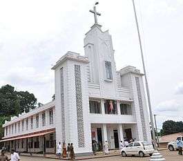
 Arakuzha Syrian Catholic Church
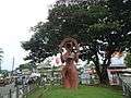 Statue at Town
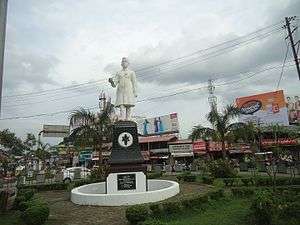
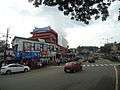 Town
Town
How to reach
- Kochi - Thrippunithura-Kolenchery-Muvattupuzha (43 km)
- Kozhikode - Feroke-Parappanangadi-Tirur-Ponnani-North Paravur-Aluva-Muvattupuzha (200 km)
- Trivandrum - Kottarakkara-Changanassery-Kottayam-Muvattupuzha (208 km)
- Kottayam - Ettumanoor-Kuravilangad-Koothattukulam-Muvattupuzha (56 km)
- Thrissur - Chalakudy-Angamaly-Perumbavoor-Muvattupuzha (80 km)
- Alappuzha - Muhamma-Thanneermukkom-Vaikom-Peruva-Piravom-Pampakkuda-Muvattupuzha (81 km)
- Munnar - Adimaly-Kothamangalam-Muvattupuzha (89 km)
- Kollam - Kayamkulam-Thiruvalla-Muvattupuzha (150 km)
- Theni - Bodinayakkanur-Pooppara-Rajakkad-Kallarkutty Dam-Neendapara-Kothamangalam-Muvattupuzha (150 km)
See also
- Muvattupuzha District Activism - The need for midland city in the immediate east of Kochi
- Will Muvattupuzha District be formed?
- Main Central Road
- NH 49
- Main Eastern Highway
- Pezhakkappilly
- Perumattom
- Kakkadasery
- Valakom
- Kalloorkad
- Vazhakulam
- Anikkad
- Arakuzha
- Memadangu
- Paipra
- Valayanchirangara
- Nellikuzhy
- Marady
- Meenkunnam
- Ayavana
- Mulavoor
References
- Menon, Girish (24 January 2012). "New district on UDF's agenda". The Hindu – via www.thehindu.com.
- "Protected Blog › Log in". inorite.wordpress.com.
- "Archived copy". Archived from the original on 2 October 2008. Retrieved 9 May 2008.CS1 maint: archived copy as title (link)
- K. M. Mathew, ed. (2006). Manorama Year Book. Malayala Manorama. p. 116.
- "Archived copy". Archived from the original on 15 November 2007. Retrieved 23 May 2006.CS1 maint: archived copy as title (link)
- "Archived copy" (PDF). Archived from the original (PDF) on 17 July 2013. Retrieved 13 June 2014.CS1 maint: archived copy as title (link)
- "Ancient Churches, Stone Crosses of Kerala- Saint Thomas Cross, Nazraney Sthambams and other Persian Crosses". 15 January 2007.
- "arakuzhachurch.org". arakuzhachurch.org.
- "Census of India 2001: Data from the 2001 Census, including cities, villages and towns (Provisional)". Census Commission of India. Archived from the original on 16 June 2004. Retrieved 1 November 2008.
- "Archived copy". Archived from the original on 10 November 2010. Retrieved 23 October 2010.CS1 maint: archived copy as title (link)
- "Clipping of deepikanewspaper - Deepika Kochi".
- "Thodupuzha, Kerela, IN".
- "Archived copy". Archived from the original on 12 September 2010. Retrieved 24 February 2010.CS1 maint: archived copy as title (link)
- May 24, Sudha Nambudiri | TNN | Updated; 2019; Ist, 19:33. "Dean Kuriakose wins by huge margin in Idukki | Kochi News - Times of India". The Times of India. Retrieved 14 August 2019.CS1 maint: numeric names: authors list (link)
- "Local Self Government Department | Local Self Government Department". lsgkerala.gov.in. Retrieved 14 August 2019.
- "Idukki Tourist Places - Munnar, Thekkady, Peerumedu, Marayoor, Kumali, Idukki Arch Dam". www.zonkerala.com.
- "Muvattupuzha river pollution: Meeting called".
- "Article about Muvattupuzha". moovattupuzha.com.
- "Wikibooks Malayalam- Aithihyamala- Kadamattathu Kathanar". Wikibooks-Malayalam. 7 June 2011. Retrieved 10 June 2011.
- "Wikimapia - Let's describe the whole world!". wikimapia.org.
- "Archived copy". Archived from the original on 14 July 2011. Retrieved 24 February 2010.CS1 maint: archived copy as title (link)
- "Kinfra park at Nellad fully occupied". The Hindu. Chennai, India. 13 November 2007.
- S, PRIYADERSHINI (19 May 2016). "Some coffee in the NEWSROOM". The Hindu. ISSN 0971-751X. Retrieved 10 April 2018.
- "Database Error". www.smcim.org.
- "Archived copy". Archived from the original on 25 March 2014. Retrieved 25 March 2014.CS1 maint: archived copy as title (link)
- "Nirmala - Medical Centre". www.nirmalamedicalcentre.com.
- "Franciscan Clarist Congregation". fccongregation.org.
- "Census data" (PDF). www.censusindia.gov.in. 2011.
- Devasia, T K. "New district plan hits a snag". www.khaleejtimes.com.
- [www.stepofweb.com], Dorin Grigoras. "GrandCentreMall". www.grandcentremall.com.
- "cinepoint.in". www.cinepoint.in.
- "Archived copy". Archived from the original on 14 July 2011. Retrieved 24 February 2010.CS1 maint: archived copy as title (link)
- http://www.mathrubhumi.com/localnews/story.php?id=151874&v_id=73%5B%5D
- "Archived copy". Archived from the original on 14 July 2011. Retrieved 24 February 2010.CS1 maint: archived copy as title (link)
- "SkyscraperPage Forum - View Single Post - Cochin highrises, pictures and projects - II". forum.skyscraperpage.com.
Sources
- Kerala PWD
- Statehighways in Yahoo Maps
- State Highway list
External links
| Wikimedia Commons has media related to Muvattupuzha. |
| Wikivoyage has a travel guide for Muvattupuzha. |
- Official Government page for Muvattupuzha in Malayalam
- Map of Eurnakulam in Kerala
- Airapuram Rubber Park Farmers Action Council
- Remaining Date for Muvattupuzha Municipality Election 2020
| Districts |
|  |
|---|---|---|
| Towns and cities |
| |