Thodupuzha
Thodupuzha (തൊടുപുഴ) is a municipality in Idukki district in the Kerala state of India, spread over an area of 35.43 km2. Thodupuzha is 57 km (35 mi) from Kottayam and 60 km (37 mi) south east of Kochi. Thodupuzha is 200 km from the state capital, Trivandrum. Geographical classification of Thodupuzha Region is Malanad or Idanad.
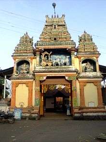
Thodupuzha Gateway of Highrange | |
|---|---|
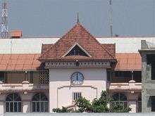
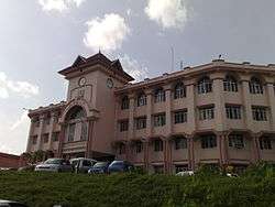 Thodupuzha Civil Station | |
 Thodupuzha Location in Kerala, India  Thodupuzha Thodupuzha (India) | |
| Coordinates: 9.896918°N 76.7113°E | |
| Country | |
| State | Kerala |
| District | Idukki |
| Government | |
| • Type | First Grade Municipality |
| • Municipal Chairperson | Mrs Jessy Antony |
| Elevation | 40 m (130 ft) |
| Population (2011)[1] | |
| • Total | 52,045 |
| Languages | |
| • Official | Malayalam, English |
| Time zone | UTC+5:30 (IST) |
| PIN | 685584 |
| Telephone code | 04862 |
| Vehicle registration | KL-38 |
| Nearest city | Kattappana, Kottayam, Muvattupuzha, Ernakulam |
| Nearest Railway Station | Ettumanoor (ETM) 45.9 Km Thrippunithura (TRTR) 50.3 Km |
| Lok Sabha constituency | Idukki |
| Climate | Tropical monsoon (Köppen) |
| Avg. summer temperature | 32.5 °C (90.5 °F) |
| Avg. winter temperature | 20 °C (68 °F) |
| Major town in the District of Idukki | |
Thodupuzha is also the name of the river that flows through the town. It is one of the largest towns in the district and is a main commercial center. The town is being modernised with the help of a program sponsored by the World Bank, financing through the Government of Kerala. It was once part of the territory of the princely state, Travancore. It lies in central Kerala, southeast of Muvattupuzha. The Thodupuzha municipality area is characterized by abundant vegetation.
Etymology
The place named 'Thodupuzha' by Elasamprathi Narayana Varma from two words, 'thodu' (which means a rivulet) and 'puzha' (which means a river). It is believed that the stream developed into a river, and the town on the banks of the river came to be known as Thodupuzha.
There is another version which defines the word ‘thodu’ (old Malayalam word) as ‘touch’ and ‘puzha’ as ‘river’. Thus the town touching the river became Thodupuzha. Mattathil Kovilakam was the protectors and rulers of the Desham (region) Thodupuzha that they were in and a reported relationship emerged to a "Naadu Vaazhi" (Ruler of the land)of Keezhmalainadu. Naadu, which is a group of Deshams, came to known as Thodupuzha. The last ruler of the desam was Elasamprathi(Ruler of a region appointed by Maharaja of Keezhmalainadu) Shri Narayana Varma Thampan originally from Trivandrum and he was the representative of Maharaja Raja. His official residence was Mattathil Kovilakam located in Chalamkode Village. Official Headquarters of Keezhmalainadu were Karikodu.
History
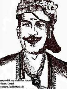
The Kings of Vadakkumkoor used to live at Karikode for several years. At the time of King Marthanda Varma, Vadakkumkoor became part of the state of Travancore. He appointed his representative 'sarvadhikari' Elasamprathi Narayana Varma Thampan of MATTATHIL from Neyyattinkara (Trivandrum) to flourish Thodupuzha. The period of his reign was the golden age of Keezhmalainadu. He erected many monuments, including the government offices, Pandika Shala and Temples. The Karikode Mosque and other buildings in Thodupuzha and Muvattupuzha also date from his reign. He was also the founder of the new style tax collection in this region. He traveled every day from Chalamkode to Karikkodu in a Pallakku (palanquin). The relics of the fort is still there at Karikode. The Annamalai Temple, which carries the traits of Tamil Architecture is at Karikode. At this temple are statues and lamps made out of stone and metal, believed to have been made in the 14th century. Thodupuzha is an ancient town with a history dating back to many centuries. The Buddhist and Jain religions which made their first inroads into Kerala in 300 BC have left their impact at Thodupuzha and neighbouring areas. The Buddhist religious relics found at Karikode near Thodupuzha is proof of this. In 14th century AD, Kerala was divided for administrative reasons into several provinces such as Venadu, Otanadu, Navishainadu, Munjunadu, Vempolinadu, and Keezhmalainadu. Thodupuzha and Muvattupuzha were in Keezhmalainadu which had its headquarters at Karikode. Keezhmalainadu was in existence till AD 1600. In that year it lost a battle with Vadakkumkoor and became a part of it. The church at Muthalakodam, a small town, 4 kilometers from Thodupuzha, is believed to have been constructed before the 13th century. The Ninnar Mosque near Karikode is said to have been constructed by Sarvadikari Elasmprathi Narayana Varma for his Muslim soldiers.
At the formation of Kerala state in 1956, Thodupuzha was part of the Ernakulam district. In 1972, Idukki district was formed by merging Thodupuzha taluk along with Devikulam, Udumbanchola and Peermade taluks, which were part of the erstwhile Kottayam district.
Climate
| Climate data for Thodupuzha, Kerala | |||||||||||||
|---|---|---|---|---|---|---|---|---|---|---|---|---|---|
| Month | Jan | Feb | Mar | Apr | May | Jun | Jul | Aug | Sep | Oct | Nov | Dec | Year |
| Average high °C (°F) | 31.8 (89.2) |
32.8 (91.0) |
33.9 (93.0) |
33.9 (93.0) |
32.9 (91.2) |
30.6 (87.1) |
29.8 (85.6) |
29.8 (85.6) |
30.5 (86.9) |
30.6 (87.1) |
30.7 (87.3) |
31.3 (88.3) |
31.6 (88.8) |
| Average low °C (°F) | 22.1 (71.8) |
23.0 (73.4) |
24.6 (76.3) |
25.5 (77.9) |
25.3 (77.5) |
24.2 (75.6) |
23.5 (74.3) |
23.7 (74.7) |
23.8 (74.8) |
23.7 (74.7) |
23.5 (74.3) |
22.4 (72.3) |
23.8 (74.8) |
| Average precipitation mm (inches) | 23 (0.9) |
43 (1.7) |
64 (2.5) |
170 (6.7) |
360 (14.2) |
705 (27.8) |
779 (30.7) |
587 (23.1) |
342 (13.5) |
368 (14.5) |
208 (8.2) |
64 (2.5) |
3,713 (146.3) |
| Source: Climate-Data.org[2] | |||||||||||||
Demographics
As of 2001 India census,[3] the total population of 46,226. Males constitute 49%of the population and females 51%. Thodupuzha has an average literacy rate of 82%, higher than the national average of 59.5%: male literacy is 84%, and female literacy is 81%. In Thodupuzha, 12% of the population is under 6 years of age.
Transportation
Road

Thodupuzha has an excellent network of roads which connects it to the nearby towns and cities. The Main Eastern Highway (Muvattupuzha - Punalur / SH-08 / 154 km) passes through Thodupuzha and connects it to two of its neighboring towns, Muvattupuzha and Pala. Thodupuzha-Puliyanmala road (SH-33) connects Thodupuzha to Idukki District centre at Painavu as well as tourist destinations like Idukki Dam and Thekkadi. Alappuzha-Madurai road (SH-40) also passes through Thodupuzha town. SH-43 which connects Muvattupuzha with Theni passes through some parts of the Thodupuzha Taluk but doesn't pass through Thodupuzha town. Other state highways, Tekkady - Ernakulam and Sabarimala - Neryamangalam also passes through Thodupuzha town. New 4 Lane Highway Proposed from Muvattupuzha to Kakkanad if materializes will connect Thodupuzha to Kochi in Less than 45 minutes to reach reducing the distance to 50 kilometres.
Thodupuzha - Pala, Thodupuzha - Muvattupuzha highways are one of the best roads in Kerala which were recently upgraded by KSTP.
The newly constructing KSRTC bus station will give depot status (now a Sub depot) to Thodupuzha KSRTC station. Many new inter state services expected to start from Thodupuzha after the commissioning of new KSRTC bus station. Bus services at frequent intervals are there to nearby places like Kottayam, Ernakulam, Vaikom, Kattappana, Thrissur, and Trivandrum from Thodupuzha. Recently this depot has added several high-tech low-floor buses, which provide luxury transportation facilities to their fleet.
Railway
At present Thodupuzha has no railway connectivity. The nearest major Railway Stations are Aluva railway station which is 55 kilometres away from Thodupuzha, Kottayam railway station is at 54 kilometres away from Thodupuzha. The proposed Angamaly-Erumely Sabari Railway to Sabarimala passes through Thodupuzha, and Thodupuzha railway station is planned to be constructed near Thodupuzha Co-operative hospital. Construction of Sabari Railway is completed up to Kalady railway station and Periyar bridge. The railway link will probably complete till Muvattupuzha and may be, up to Thodupuzha. Railways sees the terrain as difficult due to hills and loose soil in the Meenachil taluk and beyond. Also, the population density is lower in Thodupuzha,Pala and southwards, known as lowranges, in the foothills of Western ghats. There is also opposition from locals in the eastern part of Kottayam district through which the proposed railway alignment is.
Economy and infrastructure
Thodupuzha's economy is driven by agriculture, business and small industries. Farmers in Thodupuzha raise a number of crops, mostly rubber. Other crops such as pineapple, coconut, rice, pepper, cocoa, tapioca, banana, ginger, turmeric etc. are also being cultivated in plenty. In recent years Thodupuzha has showed more interest in promoting tourism. The face of Thodupuzha changed a lot in the last decade owing to developments since the changeover of the status from Taluk to Municipality. The new private bus stand, Temple Bypass road, Kanjiramattom Bypass road, Kothayikkunnu Bypass, Vengaloor Bypass, Mangattu Kavala four-lane road, Mini Civil Station, New Bridge, Municipal Park, Shopping complex at bus stand, New Townhall complex etc. are noted landmarks which changed the look of Thodupuzha to a planned city. The first manufacturing industry in the District, Dhanwanthari Vaidyasala has its headquarters in Thodupuzha. The footwear brand Lunar's has its operations base at Thodupuzha. Thodupzha is strategically located in route of Highranges to other Central Kerala towns like Ernakulam and Kottayam. However the lack of well developed roads from Highranges to reach Thodupuzha has led to the usage of Aluva - Munnar road and Kottayam - Kumaly road as the main transport route by the people of the uplands. The are new proposed state highways: Tekkady - Ernakulam and Muvattupuzha - Theni.
Politics
Thodupuzha was administered by a village panchayat and village union for several years, but on 1 September 1978, Thodupuzha was upgraded into a municipality. The Thodupuzha Municipality was formed by merging the Thodupuzha Panchayat and the neighbouring Panchayats of Kumaramangalam, Karicodu and Manacaud. The municipality was administered by a special officer for ten years. In 1988, elections were held and the first popularly elected municipal council came into existence with Advocate N. Chandran as the Chairman. Today the Municipality has 35 wards. There is a Chairman, a Vice Chairman, and various Standing Committees to carry out the civic administration. Safiya Jabbar of the UDF is the present Municipal Chairperson of Thodupuzha Municipality following the Kerala Local Self Government institutions election in 2015.[4]
Thodupuzha is an assembly constituency and P J Joseph is the present MLA of Thodupuzha. He got elected 9th time from Thodupuzha marked with highest majority in the 2016 Kerala assembly of 45,587 votes . He is admired for the planned developments carried out during the tenure as MLA and Minister. Knowledge city, Malankara dam tourism project, Sports complex and Thodupuzha ring roads are his proposals. Thodupuzha assembly constituency is part of Idukki (Lok Sabha constituency) for which Dean Kuriakose is the present MP.
Healthcare
There are at least 2150 hospital beds within the municipal area, serving a population less than 50,000 making a hospital beds per 1000 population of about 250 which is above UK average of 3.78 and USA average of 3.32. Besides, Thodupuzha is also an important hub of alternate medicine, with three major Ayurvedic groups having their headquarters in Thodupuzha including the 85-year-old Dhanwanthari Group. There are so many hospitals in Thodupuzha area. Some of the hospitals in the area include District Ayurveda Hospital, Taluk Hospital (Karikode), St. Mary's Hospital (Idukki Road), Holy Family Hospital(Muthalakodam), Chazhikattu Hospitals, Archana hospital (Muvattupuzha Road), Mount Sinai Hospital (Mount Sinai Road), St Josephs Hospital and Children's Clinic (Mount Sinai Road). Al Azhar medical college at Ezhallor is 7 km away from the town. Thodupuzha taluk hospital got upgraded to District hospital recently. A specialty hospital and cancer center is being constructed near Vengaloor junction.
The Ayurvedic Group Dhanwanthari Vaidyasala (Estd.1933) has a 100-bed Ayurvedic Hospital In Thodupuzha.
Smita Memorial Hospital and Research Centre (SMHRC) Thodupuzha, Kerala
The proposed hospital at Thodupuzha is intended to be a multi-specialty hospital, located between the Thodupuzha – Moovattupuzha High Way Road and the perennial Thodupuzhayayr. It is a 416-bed hospital with 334 single rooms, 6 operation theatres, 5 ICUs and other amenities. It is planned to be the first fully specialized cancer center in central Kerala.
Entertainment
Movie theaters
- Aashirvad Cineplexx Aashish, 2K DOLBY ATMOS, 3D
- Aashirvad Cineplexx Anisha, 2K DOLBY ATMOS, 3D
- Aashirvad Cineplexx Pranav, 4K DOLBY ATMOS, 3D
- Aashirvad Cineplexx Vismaya, 4K DOLBY ATMOS, 3D
- Silver Hills Cinemas Screen 1 4K
- Silver Hills Cinemas Screen 2 4K
- Silver Hills Cinemas Screen 3
- Vismaya Cinemax
- New Theatre
Tourist attractions
Although Thodupuzha itself is not a major tourist destination, it is the gateway to Munnar, Thekkadi, Idukki Dam, and Peermade.
Thommankuthu
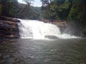
Thommankuthu is a famous tourism destination 20 km from Thodupuzha, has a series of waterfalls. In addition, there are several caves and viewpoints. The waterfall in Kaliyar river origins from the hills Palkulam medu, 4000 feet above sea level.
Uravappara
Uravapara is a hillock temple situated at Olamattom near Thodupuzha, at a height of 500 ft above sea level. Today, Uravapara is known for its religious activities. The annual festival of the temple is conducted in the Malayalam month ‘Makaram’ (January/February) each year.
Illikal Kallu
Illikal Kallu (Malayalam: ഇല്ലിക്കല് കല്ല്) is a major tourist attraction spot in Kottayam district of Kerala (India). Situated about 3400 feet above sea level, it is also one of the highest peaks in the Western ghats. Illikal Kallu is a rock situated above Illikal Mala. The thing that makes this rock unique is that half of the rock has fallen off, and only the other half remains. This supplements the mountains which surrounds the rock. It is 30 km away from Thodupuzha.
Malankara Dam
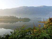
Malankara, which is situated at a distance of 6 km from Thodupuzha is an upcoming tourist destination. Malankara is known for its irrigation project, the Malankara Dam, the Reservoir constructed across the tail waters of Moolamattom Power House. This artificial lake is located near to the Thodupuzha – Moolamattom Road (State Highway 33) covering an area of around 11 km. Malankara Dam is a gravity dam and is a project of Muvattupuzha Valley Irrigation Project and KSEB ( Kerala State Electricity Board ). Constructed across the Thodupuzha river for the purpose of irrigation, this reservoir is a picnic spot, too. There is also a park nearby the reservoir, which is under construction. The Malankara Tourism Project has been launched by the Department of Tourism and the site will be soon turned into a tourist spot. As a part of the project, steps are being taken by the Government of Kerala for the protection of trees and developing the area to an entertainment park.
Ilaveezhapoonchira
Ilaveezha Poonchira is one of the tourist destinations in Kerala. Spread over thousands of acres of the Kottayam district, the valleys of Ilaveezhapoonchira is a picnic spot. Situated at a distance of 24 km from Thodupuzha via Kanjar and 20 km via Kanjiramkavala, the spot located at the foot of the hillocks of Mankunnu, Kudayathur hill and Thonippara, each rising to about 3200 ft above sea level, makes it a place for trekking. At the top of these hills, one can view large parts of Idukki, Kottayam, Ernakulam, Alapuzha, Pathanamthitta and Thrissur districts.
Moolamattom Power House
The Idukki Hydroelectric Project is the biggest hydrolectric project in Kerala (India). It comprises three dams at Idukki, Cheruthony and Kulamavu and related systems. The power house at Moolamattom is the longest underground power station in India and the pressure shaft is the largest in the country. The Idukki Dam is one of the highest dams in the world and the first arch dam in India. Cheruthony is the largest and highest gravity dam in Kerala. The project harnesses a major portion of the power potential of Periyar, the largest river in Kerala, by the creation of a reservoir of 2,000 M.cum (2 Billion Tonnes) capacity, diversion of waters thus impounded through a water conductor system consisting of a power tunnel and two underground pressure shafts to an underground power house situated in Moolamattom. The installed capacity of the Power House is 780MW consisting of 6 Units of Pelton-type turbines with a power generation capacity of 130 MW each. The regulated waters of Periyar falls through a drop of about 669.2 metres (2195 feet) while generating power in the underground power house. The tail waters flowing to river Kanjar through tunnel and open channel is diverted for irrigation purposes in the Muvattupuzha Valley. Visitors are only allowed to visit the area under special permissions due to security reasons.
Thumpichi Calvery Samuchayam
This is a Christian Pilgrim Centre and the pilgrims climb up the hill during Lent and Good Friday. The way to the mountain is graced by the 14 crosses placed at regular intervals.
Elappally Waterfalls

Elappally is 26 km from Thodupuzha town, 106 km from Kochi city. The Elappally Falls are situated on the Moolamattom - Wagamon road, which originates in the upper reaches of the Western Ghats. This fall will be active only in monsoon season and will be dry during the summer season.
Wagamon

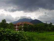
Wagamon is a hill station situated 1200 meters above sea level, 42 km from Thodupuzha.
The hill station also provides option of trekking, paragliding or rock climbing for adventurous seekers. The place has many varieties of flora and fauna located in various parts of hilly region. Evergreen trees, tall grasses and shrubs are present in the lower regions of Wagamon. Many rare species of birds, insects, wild buffaloes and elephants can be easily located in the forests. The main attractions here are mist-covered mountains and lakes, Pilgrim centers – Kurishumala, Murugan temple, Burial chamber of Sufi saint and pine forests.
Chalachitra Nagari
Thodupuzha has attracted many Malayalam movie makers. The films Vasanthiyum Lakshmiyum Pinne Njanum, Vargam, Nasrani, Manassinakkare, Kunjikoonan, Rasathanthram, Palunku, Detective, Veruthe Oru Bharya, Film Star, Swantham Lekhakan, Kadha Parayumbol, Samastha Keralam PO, Pappy Appacha, Vairam: Fight For Justice, Janapriyan, Arya, Swapnam Kondu Thulabharam, Elsamma Enna Aankutty, Marykkundoru Kunjaadu, Oridathoru Postman, Detective, Vismayathumbathu, Sringaravelan Swapna Sanchari, 101 Weddings, Evidam Swargamanu, Daivathinte Swantham Cleetus, Drishyam (Tamil and Malayalam), Om Shanti Oshana, Vajram, Rebecca Uthup Kizhakkemala, Vellimoonga, Thoppil Joppan, Oppam, Kattappanayile Rithwik Roshan, Swarna Kaduva, Aadupuliyattam, Janapriyan, Aadu, and [[Aadu 2] were shot in and around Thodupuzha.
Kaypa Kavala[5] is a sleepy little place, and it was here that the climax for the movie ′Drishyam′ was shot in both Tamil and Malayalam. The place also has a shop where the hero had his mobile TV shop.[5]
Kaatadikkadavu
Situated 25 km[6] from Thodupuzha, Kaatadikkadavu is hidden away and hard to find. There is a bit of a climb on foot though the view from the top is rewarding.
Education
- The first center of higher learning which started functioning in Thodupuzha Taluk was Newman College, Thodupuzha. It was established in 1964 by the Syrian Catholic Diocese of Kothamangalam, and named after Cardinal Newman.
- The second college of Thodupuzha was established in 1982: St.Joseph's College at Arakkulam.
- The University College of Engineering, Thodupuzha managed and run by the Mahatma Gandhi University, Kottayam, is located in Thodupuzha which is the first of its kind in the state of Kerala. The college started functioning in 1996. The college campus is located over 25 acres (100,000 m2) of land at Muttom, 7 km from Thodupuzha, by the side of State Highway No 33.
- College of Applied Science, Thodupuzha operates in the field of IT and Electronics education in Idukki district affiliated to MG University. Established in 2000, the college is managed by Institute of Human Resources Development (IHRD) Thiruvananthapuram, a Government of Kerala undertaking established in 1987. The college is situated at a distance of 2 km from Thodupuzha town by the side of Thodupuzha-Idukki road.
Other colleges in Thodupuzha include
- Santhigiri College at Vazhithala
- Al Azhar Medical College & Super Speciality Hospital[7]
- Viswajyothi College of Engineering, vazhakkulam
- Dhanwanthari Institute of Paramedical Sciences
- Al-Azhar College of Arts and Science
- Al-Azhar Dental College
- Al-Azhar college of Engineering & Technology
- Al-Azhar Training college, Thodupuzha East Perumpillichira
- College of Applied Science, Olamattom
- St. Thomas College of Teacher Education.
Some of the schools in Thodupuzha include
- De Paul Public School
- Jai Rani Public School
- The Village International School, MKNMHSS Kumaramangalam
- Co-operative Public School
- NSS Higher Secondary School Manakkad
- St sebastians HS Thodupuzha
- Vimala Public School
- THSS Muttom[8]
The engineering colleges around Thodupuzha are
- Al-Azhar college of Engineering &Technology
- The University College of Engineering - run by Mahatma Gandhi University.[9]
Law Colleges
- Co-operative School of Law, Thodupuzha affiliated by Mahatma Gandhi University, Kerala
- Al Azhar Law College
Places of worship
- Kingdom Hall of Jehovah's Witnesses , East Vadakkummuri,Thodupuzha
- Amaramkavu Durga temple
- Thodupuzha SreeKrishna Swami Temple
- Kanjiramttom Shiva Temple
- Uravappara Subramanya Swami Temple
- Manakkad Narasimha Swami Temple
- Muthaliyarmadom Mahadeva Temple
- Karikode Bhagavathy Temple
- Sreekrisna temple Edavetty
- Ayyappa temple Thekkumbhagom
- St. Sebastian's Forane Church, Thodupuzha
- Karikode Nainar Juma Masjid
- Thodupuzha Town Juma Masjid
- Annapurneswari Temple, Thodupuzha
- St George Forance Church, Muthalakodam
- St Marys Forane Church, Chunkom
- St Mary's church nakapuzha
- St Mary's church Nediyasala
- Newman College Church, Thodupuzha
How to reach
Thodupuzha, although situated on the easternmost portion of the midlands starting just east of Kochi, is accessible from every part of the state due to good road connectivity. Although, eastern and southern parts connectivity is affected by the hilly geography owing to being closer to Western Ghats (High Ranges), the connectivity to Muvattupuzha in the western side gives Thodupuzha region easy access to most of the destinations. The important highway passing through the town is Punalur-Muvattupuzha Main Eastern Highway. This hill highway connects a string of towns lying on the border of Western ghats including Punalur, Pathanapuram, Konni, Ranni, Ponkunnam, Pala and Thodupuzha to the major intersection at Muvattupuzha, where Main Central Road and NH 49 meets. Other major roads are Thodupuzha-Puliyanmala highway connecting to Idukki, Kattappana and other parts of high ranges. Thodupuzha-Muttom-Erattupetta, Thodupuzha-Muthalakodam-Vannappuram, Thodupuzha-Vaikom roads also are strategic roads to Thodupuzha.
- Kochi: Thrippunithura-Kolenchery-Muvattupuzha-Thodupuzha (59 km)
- Trivandrum: Kottarakkara-Changanassery-Kottayam-Pala-Thodupuzha (208 km)
- Kottayam: Ettumanoor-Pala-Thodupuzha (56 km)
- Thrissur: Chalakudy-Angamaly-Perumbavoor-Muvattupuzha-Thodupuzha (100 km)
- Alappuzha: Muhamma-Thanneermukkom-Vechoor-Manjoor-Kuravilangadu-Koothattukulam-Marika-Vazhithala-Thodupuzha (83 km)
- Munnar: Pallivasal-Adimaly-Oonnukal-Paingottur-Vengallur-Thodupuzha (93 km)
- Theni: Cumbum-Kumily-Kattappana-Idukki-Thodupuzha (158 km)
- Kozhikode: Muvattupuzha-Thrissur-Kunnamkulam-Edappal-Ramanattukara (211 km)
Notable people
- Asif Ali, film actor
- Askar Ali, film actor
- Asin, film actress
- Dr P. K. Abdul Aziz, vice-chancellor of Aligarh Muslim University
- P. J. Joseph, leader of Kerala Congress and former minister in the Second Oommen Chandy ministry
- Neeta Pillai, film actress
- Pappachen Pradeep, defender for the India national football team, former captain of the U23 team.
- Honey Rose, film actress
- Nishanth Sagar, film actor[10]
- Rajesh Touchriver, film director
- Shiny Wilson (née Abraham), Olympian and Asian Games Medal Winner
Landmarks
- Gandhi Square
- Sri Krishna temple, Thodupuzha
- Dhanwanthari Junction
- Dharmoo's Fish Hub
- St.Mary's Forane Church, Chunkom
- Geminy Tourist Home & Hotel, Manakkad Jn, Thodupuzha
- Karikode Nainar Juma Masjid
- St. Sebastian's Forane Church, Thodupuzha
- St George Forane Church, Muthalakodam
- Karikode Devi Temple
- Manakkad Narasimha Swami Temple
- Kanjiramattom Siva Temple
- Newman College
- Kanjiramattom Junction
- St.Mary's Church Nediyasala
See also
References
- "Census of India: Search Details". Censusindia.gov.in. Retrieved 9 April 2016.
- "CLIMATE: THODUPUZHA", Climate-Data.org. Web: .
- "Census of India 2001: Data from the 2001 Census, including cities, villages and towns (Provisional)". Census Commission of India. Archived from the original on 16 June 2004. Retrieved 1 November 2008.
- "November 18 in pics". Mathrubhumi. Retrieved 25 April 2016.
- http://travel.manoramaonline.com/travel/celebrity-travel/2017/07/14/kaypa-kavala-celluloid-fame-drishyam.html
- "Google Maps". Google Maps. Retrieved 12 December 2016.
- "Al-Azhar Super Speciality Hospital And Medical College (AAMC)". www.aamc.org.in. Retrieved 12 December 2016.
- "Technical HS Schools". Institute of Human Resources Development. Retrieved 2 July 2015.
- "University College of Engineering, Thodupuzha". ucet.ac.in. Retrieved 2 July 2015.
- http://www.malayalammovies.org/artist/nishanth-sagar
External links
| Wikimedia Commons has media related to Thodupuzha. |
| Wikivoyage has a travel guide for Thodupuzha. |
Destinations from Thodupuzha | ||||||||||
|---|---|---|---|---|---|---|---|---|---|---|
| ||||||||||