Cherukunnu
Cherukunnu is a census town in Kannur district in the Indian state of Kerala.[1][2]
Cherukunnu Little Hill | |
|---|---|
town | |
 Annapoorneshwari Temple, Cherukunnu | |
| Coordinates: 12.01065°N 75.27039°E | |
| Country | |
| State | Kerala |
| District | Kannur |
| Talukas | Kannur |
| Government | |
| • Body | Panchayat (First Grade) |
| Area | |
| • Total | 15.37 km2 (5.93 sq mi) |
| Population (2011) | |
| • Total | 23,030 |
| • Density | 1,057/km2 (2,740/sq mi) |
| Languages | |
| • Official | Malayalam, English |
| Time zone | UTC+5:30 (IST) |
| PIN | 670301 |
| Telephone code | 0497 |
| ISO 3166 code | IN-KL |
| Vehicle registration | KL-13 |
| Sex ratio | 1163 ♂/♀ |
| Literacy | 87.35% |
| Lok Sabha constituency | Kasaragode |
| Vidhan Sabha constituency | Kalliasseri |
| Civic agency | Panchayat (First Grade) |
| Climate | pleasant (Köppen) |
Demographics
As of 2011 India Census, Cherukunnu had a population of 23,030 with 10,646 males and 12,384 females.[3]
Cherukunnu is a tiny village tucked on Kannur-Payyannur hi-ve, situated near Pazhayangadi in Kannur District of North Malabar region in Kerala. [1][2]
Etymology
The name Cherukunnu means Little Hill ("cheru-ചെറു"=Little and "kunnu-കുന്ന്"=hill). There are about five very small hills surrounding this place. The name Cherukunnu is believed to have been derived owing to the presence of these Hills. However, as per a local Hindu mythological belief, the "Choru-Kunnu" (heap of cooked rice) which is made just before the daily "Annadhaanam" (free feast) at Annapoorneswari Temple gave the place this name.
Main hills
- Kaarakkunnu,
- Keezharakkunnu,
- Paadiyil-Kunnu,
- Chedangeel-Kunnu and
- Kunnanangad-Kunnu
History
During Kolathiri rule, Cherukunnu was under their reign. Later, Tipu Sultan adjoined this area as part of Kingdom of Mysore. The British Raj put this place under Chirakkal Taluk of Malabar District in Madras Presidency. Presently this is a village of Kannur District of Kerala State.
Culture and geography
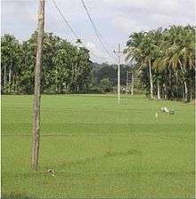
Greater part of this village is surrounded by Backwater. The thuruths (small islands) of "Ayiram Thengau" and "Mungam" are places of interest known for scenic beauty. This village shares borders with Kannapuram to the south, Madayi to the north, Mattool to the west, Ezhome and Pattuvam to the east.[4]
Cherukunnu (ചെറുകുന്ന്) is famous for:
- Thavam Roman Catholic church;[5]
- Oliyankara Juma Masjid;[6]
- Annapoorneswari Temple;[7]
- Mission Hospital.
Thavam Church
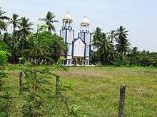
The Thavam Church is a famous Roman Catholic Church of North Malabar. This church is very old which proclamates the presence of Christians in North Malabar since ancient days. This is a heritage place for North Malabar Roman Catholic society. This church is under the Diocese of Kannur. This church is located at Thavam; between Cherukunnu and Pazhayangadi, around 17 km from Kannur, 19 km from Taliparamba and 15 km from Payyannur.[5] Pazhayangadi is the nearest rail head. Other Roman Catholic churches of Cherukunnu are at Kattakulam, Paadiyil Ferry and Kavinisseri (Christhukunnu).
Oliyankara Juma Masjid
Oliyankara Juma Masjid (Hazrath Valiyullahi (RA)), a Famous Dargah Shareef of Sahaba-e-Ikhram (Sufi Saints/Auliyas) is an important Mosque of North Malabar. It is believed that the priests in ancient days gave importance to the Hindu Gods at this Mosque. The Mosque is at Pallichal near Cherukunnu town, around 14 km from Kannur, 16 km from Taliparamba and 18 km from Payyannur. This is a location of a famous sufi grave, visited by people of all religions.[6]
Kannapuram is the nearest rail head.
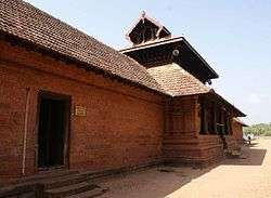
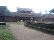
Annapoorneshwari Temple
At this Temple, Lord Krishna is collocated with Sree Annapoorneswari. It is believed that Sree Annapoorneswari has visited this shrine which was under the sea. There is a mythological belief that this shrine was elevated by Lord Parashurama. The temple is near Cherukunnu town, around 14 km from Kannur, 16 km from Taliparamba and 18 km from Payyannur. A large chira (swimming pool) also can be spotted near this temple.[8]
In April every year, various religious and ritual and entertainment activities, including spectacle fireworks, are shown at this Temple to during the celebration of Vishu Villakulsavam.[9]
Kannapuram is the nearest rail head.
Mission Hospital
Mission Hospital alias St. Martin de Porres Hospital Cherukunnu is a very famous hospital of this region. Presently this hospital is equipped with all modern ultra medical facilities and is also a super speciality hospital having 24 hours Casualty and Trauma Care Centre. The Leprosy Department of this hospital provides free of cost treatment to Leprosy patients. This hospital is attached with a Nursing College viz. "Canossian College of Nursing" run by "Canossian Daughters of Charity" Convent Cherukunnu.[10][11][12]
Administration
- District: Kannur
- Taluk/Tehsil: Kannur
- Block: Taliparamba
- Assembly constituency: Kalliasseri
- Police Station: Kannapuram
- Post Office & PIN : Cherukunnu-670301
- Telephone Exchange: Cherukunnu (0497)
- Panchayat Office Contact : 0497-2860238
- Nearest Railway Stations: South-Kannapuram and north-Pazhayangadi.[4]
Education
The average literacy rate is more than 90%. The important schools of Cherukunnu are:
- Govt. Vocational Higher Secondary School
- Govt. Higher Secondary School
- Govt. Welfare Higher Secondary School
- Govt. LP School Cherukunnu
- Othayammadam UP School
- Thavam Devi Vilasam LP School
- Bakkitha Canossa English Medium School
- Muslim L P School Pallichal
- Bright English School
The important Colleges are:
- Canossa College of Nursing
- Co-operative Arts& Science College
- Akshara College
- Society College
- Govt. Commercial Institute
- MES College
Arts
Cherukunnu plays a vital role in nourishing the arts and culture of Kannur District, and is home to various Arts & Music Institutions, which are popular in district level
Suburbs and villages
- Kathirvaykum Thara, Pallichal and Koovappuram
- Vellarangeel, Punnacherry and Thavam.
- Kavinisseri, Padiyil and Kunnanangad
- Ambalappuram, Othayammadam and Thekkumbad
- Mungam, Kattakkulam, Dalil, Muttil, Mundappuram and Poongavu
Politics
After re-constituting; Cherukunnu is under Kalliasseri Assembly constituency which is part of Kasaragod (Lok Sabha constituency). Earlier, this place was under Azhikode Assembly constituency which is part of Kannur (Lok Sabha constituency). Presently, the following persons represents this Village on behalf of its people.[13]
Cherukunnu Panchayath
|
Major attractions
- Islands of Ayiramthengu and Mungam
- Chira at Annapoorneswari Temple
- Scenes -specially of river- from small hills of Padiyil, Kavinisseri and Kunnanangadu.
Transportation
The national highway passes through Taliparamba town. Goa and Mumbai can be accessed on the northern side and Cochin and Thiruvananthapuram can be accessed on the southern side. The road to the east of Iritty connects to Mysore and Bangalore. The nearest railway stations are Pazhayangadi and Kannapuram on the northern and southern sides respectively in the Mangalore-Palakkad line. Trains are available to almost all parts of India subject to advance booking over the internet. There are airports at Kannur, Mangalore and Calicut. All of them are international airports but direct flights are available only to Middle Eastern countries.
References
| Wikimedia Commons has media related to Cherukunnu. |
- "Census of India : Villages with population 5000 & above". Registrar General & Census Commissioner, India. Archived from the original on 8 December 2008. Retrieved 10 December 2008.
- "Kannur.gov.in : Villages of Kannur District". Archived from the original on 27 February 2018. Retrieved 7 July 2010.
- "Cherukunnu Town Population - Kannur, Kerala". Census India. Retrieved 29 September 2018.
- "Kannur District Map : Villages of Kannur". Archived from the original on 3 March 2016. Retrieved 7 July 2010.
- "Diocese of Kannur : Organisation Structure". Retrieved 7 July 2010.
- "Aulia-e-hind : List of Daragahs in Kerala". Retrieved 7 July 2010.
- "Kerala Tourism : Tourist places of Cherukunnu". Retrieved 7 July 2008.
- "Temples of Kerala : List of Famous Hindu Temples in Kerala". Retrieved 7 July 2010.
- "India9 : Temples in India". Retrieved 7 July 2010.
- "Healthy Family Happy Family : Human Anatomy Study". Retrieved 13 July 2010.
- "SMDP Hospital : College of Nursing". Retrieved 13 July 2010.
- "Study Nation : Colleges in India". Archived from the original on 16 July 2011. Retrieved 13 July 2010.
- "Assembly Constituencies - Corresponding Districts and Parliamentary Constituencies" (PDF). Kerala. Election Commission of India. Archived from the original (PDF) on 30 October 2008. Retrieved 19 October 2008.
- "Kerala Tourism : Tourist places of Cherukunnu". Retrieved 7 July 2008.