Paravur, Kollam
Paravur (Paravoor), is a town and a municipality in the Kollam district of the Indian state of Kerala. Paravur railway station is the last station in Kollam district which is on the route to Trivandrum while going towards South.[3]
Paravur Paravoor | |
|---|---|
Municipal Town | |
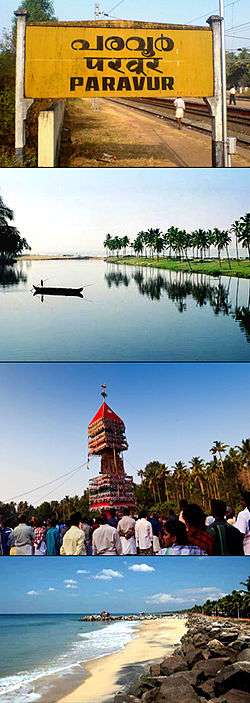 From top: Paravur railway station, Paravur Lake(Kaayal), Aayiravilli Temple Festival, Pulimuttu in Paravur Pozhikara | |
 Paravur Location in Kerala, India | |
| Coordinates: 8.811°N 76.669°E | |
| Country | India |
| State | Kerala |
| District | Kollam |
| Native Language | Malayalam |
| Established | 1932 |
| Government | |
| • Type | Municipal Council |
| • Body | Paravur Municipality |
| • Municipal Chairman | K. P. Kurup |
| Area | |
| • Total | 19.19 km2 (7.41 sq mi) |
| Population (2011) | |
| • Total | 43,739[1][2] |
| Demonym(s) | Paravurian, Paravurkkaran |
| Languages | |
| • Official | Malayalam, English |
| Time zone | UTC+5:30 (IST) |
| PIN | 691 301 |
| Telephone code | 0474 |
| Vehicle registration | KL-02 |
| Nearest city | Kollam (22 kilometres (14 mi)) |
| Assembly Constituency | Chathannoor |
| Lok Sabha Constituency | Kollam |
| Taluk | Kollam |
| Website | www |
Administration
Paravur Municipality consists of Kottapuram, Koonayil, Thekkumbhagam, Chillakkal, Perumpuzha, Nedungolam, Pozhikara, Maniyamkulam, Kurumandal, Kottamoola, Attinpuram & Kochalummoodu.[4] Paravur Municipality is a Grade-II Municipality of Kerala.
Geography
Paravur is located at 8.78 N 76 E.[5] It has an average elevation of 10 metres (32 feet). Paravur, 21 kilometers from the Kollam, is a narrow skirt of land stretching in between the backwaters and the sea. There is an elevation of 6 metres above sea level, extending to 16 metres on the inland.
Demographics
As of 2011 India census,[6] Paravur has a population of 43,739 (38,652 is the urban population and 5,087 is the village population). Males constitute 47% of the population and females 53%. Paravur has an average literacy rate of 79%, higher than the national average of 59.5%: male literacy is 81%, and female literacy is 77%. In Paravur, 10% of the population are under 6 years of age. Total number of households are 9,155.
History
Pozhikara was the administrative headquarters of Paravur. Remnants of the old fort, Thaana (police station) and Anchalappees (post office) still remain.[7] A mint of the erstwhile Travancore Kingdom for printing and punching their currencies was once situated at Paravur.[8] Paravur panchayat was formed in 1936 as one of the four panchayats sanctioned by Sir C.P.Ramaswamy Iyer (Diwan-Travancore).
Transport
Road
There are so many important roads in Paravur, connecting Kollam city and neighbouring towns like Chathannoor, Parippally, Varkala, Poothakkulam etc. The 14.1 km long Paravur-Kollam Coastal Road is connecting Kollam city with Paravur, via Kollam Beach, Paapanasam Beach, Kakkathoppu, Mukkom, Thanni and Pozhikara.[9][10]
Rail
Paravur railway station, an "Adarsh station", is situated at a distance of half kilometer away from the heart of Paravur town. Paravur is connected to various cities in India through Indian Railways.[11]
Industrial development
As part of the industry sector development plans of Kollam district, an IT Park would be setting up at Paravur Municipal area in an extent of 5 acres of land. The land can be acquired with the assistance of Land Use Board or Paravur Municipality. rail-Road linkages will be established. The Government also have plans to set up a Coir manufacturing unit and a Handloom unit at Paravur and considering the possibilities for setting up a food park also.[12]
People from Paravur
- K. C. Kesava Pillai (1868-1914) poet
- G. Devarajan (1927-2006) music composer
- P. Ravindran (1922-1997) Politician Ex Minister
- C.V. Padmarajan Politician Ex Minister
- P. K. Gurudasan Politician Ex Minister
- Paravoor Ramachandran (1945-2011) Malayalam film actor
See also
- Paravur temple accident
- Paravur Lake
- Paravur Thekkumbhagam
- Kollam Beach
- Kollam District
- Puttingal Temple
- Pozhikkara
- Chirakkara
- Poothakkulam
- Polachira
Climate
Köppen-Geiger climate classification system classifies Paravur's climate as tropical wet and dry (Aw).
| Climate data for Paravur | |||||||||||||
|---|---|---|---|---|---|---|---|---|---|---|---|---|---|
| Month | Jan | Feb | Mar | Apr | May | Jun | Jul | Aug | Sep | Oct | Nov | Dec | Year |
| Average high °C (°F) | 30.2 (86.4) |
30.9 (87.6) |
31.9 (89.4) |
31.9 (89.4) |
31.4 (88.5) |
29.2 (84.6) |
28.8 (83.8) |
29.1 (84.4) |
29.4 (84.9) |
29.5 (85.1) |
29.3 (84.7) |
29.6 (85.3) |
30.1 (86.2) |
| Daily mean °C (°F) | 26.4 (79.5) |
27.1 (80.8) |
28.2 (82.8) |
28.6 (83.5) |
28.3 (82.9) |
26.5 (79.7) |
26.1 (79.0) |
26.4 (79.5) |
26.6 (79.9) |
26.6 (79.9) |
26.4 (79.5) |
26.1 (79.0) |
26.9 (80.5) |
| Average low °C (°F) | 22.6 (72.7) |
23.3 (73.9) |
24.6 (76.3) |
25.4 (77.7) |
25.3 (77.5) |
23.9 (75.0) |
23.5 (74.3) |
23.7 (74.7) |
23.8 (74.8) |
23.8 (74.8) |
23.5 (74.3) |
22.7 (72.9) |
23.8 (74.9) |
| Source: Climate-Data.org[13] | |||||||||||||
Places adjacent to Paravur, Kollam | |
|---|---|
References
- "Kollam District Level Statistics 2011". censusindia.gov.in. 2012. Archived from the original on 26 June 2015. Retrieved 2 January 2014.
- "Kollam District Level Statistics 2011". censusindia.gov.in. 2012. Archived from the original on 2 January 2014. Retrieved 2 January 2014.
- "Paravur railway station", Wikipedia, 2 September 2019, retrieved 10 September 2019
- "Municipal wards in Paravur". Archived from the original on 24 September 2015. Retrieved 6 November 2017.
- Falling Rain Genomics, Inc – Paravur
- "Census of India 2001: Data from the 2001 Census, including cities, villages and towns (Provisional)". Census Commission of India. Archived from the original on 16 June 2004. Retrieved 1 November 2008.
- History of Paravur
- "Every coin counts". Retrieved 11 May 2015.
- "Annual Plan write up 2014(for Transport and Communication)". Finance Department-Government of Kerala. Retrieved 11 March 2015.
- "Kollam-Paravur coastal road to be revived". The Hindu. Retrieved 11 March 2015.
- Paravur Railway Station - Indiarailinfo.com
- Town planning-Kollam Archived 2014-04-18 at the Wayback Machine
- "Climate: Paravur - Climate graph, Temperature graph, Climate table". Climate-Data.org. Retrieved 27 August 2013.
External links
- Remaining Date for Paravur Municipality Election 2020
- No URL found. Please specify a URL here or add one to Wikidata.

| Wikimedia Commons has media related to Paravur, Kollam. |
| History |
| ||||||||||||||||||||||||||
|---|---|---|---|---|---|---|---|---|---|---|---|---|---|---|---|---|---|---|---|---|---|---|---|---|---|---|---|
| Geography | |||||||||||||||||||||||||||
| Zones |
| ||||||||||||||||||||||||||
| Administration & authorities | |||||||||||||||||||||||||||
| Economy |
| ||||||||||||||||||||||||||
| Visitor attractions |
| ||||||||||||||||||||||||||
| Healthcare |
| ||||||||||||||||||||||||||
| Buildings & structures | |||||||||||||||||||||||||||
| Shopping centres | |||||||||||||||||||||||||||
| Culture | |||||||||||||||||||||||||||
| Sports & stadiums |
| ||||||||||||||||||||||||||
| Places of worship |
| ||||||||||||||||||||||||||
| Other topics | |||||||||||||||||||||||||||
| |||||||||||||||||||||||||||
| |||||||||||||||||||||||||||
| |||||||||||||||||||||||||||
| |||||||||||||||||||||||||||
| City Corporations |  | ||||||||||||
|---|---|---|---|---|---|---|---|---|---|---|---|---|---|
| Municipalities | |||||||||||||
| Revenue Divisional Office | |||||||||||||
| Talukas and villages |
| ||||||||||||
- http://www.ndtv.com/kerala-news/kerala-temple-fire-pm-modi-heads-to-kollam-with-15-doctors-1371603
- https://www.indiatoday.in/magazine/the-big-story/story/20160425-kollam-temple-tragedy-puttingal-devi-kerala-fireworks-828764-2016-04-14
- https://www.thehindu.com/news/cities/kozhikode/remembering-a-master-composer/article6460893.ece
- https://www.thehindu.com/news/national/kerala/paravurkollam-coastal-road-opened-to-traffic/article8027887.ece