Koyilandy
Koyilandy (formerly Quilandy)[2] is a municipality in the taluk of the same name in Kozhikode district, Kerala on the Malabar Coast. The town is located between Kozhikode (Calicut) and Vadakara (Badagara) on National Highway 66.. Koyilandy is sometimes identified with Tyndis in Periplus of the Erythraean Sea.
Koyilandy Quilandy | |
|---|---|
Municipality | |
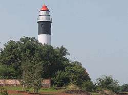 Kadaloor Point lighthouse, Koyilandy | |
| Coordinates: 11.439°N 75.695°E | |
| Country | |
| State | Kerala |
| District | Kozhikode |
| Area | |
| • Total | 29 km2 (11 sq mi) |
| Area rank | 20 |
| Elevation | 2 m (7 ft) |
| Population (2011)[1] | |
| • Total | 71,873 |
| • Rank | 20 th |
| Demonym(s) | koyilandikaran |
| malayalam | |
| • Official | Malayalam |
| Time zone | UTC+5:30 (IST) |
| PIN | 673305 |
| Telephone code | 0496 |
| ISO 3166 code | IN-KL |
| Vehicle registration | KL 56 |
| Website | www |
The freedom fighter K. Kelappan was born in a nearby village, Muchukunnu.[3]
Koyilandy is located at 11.43°N 75.70°E[4] at an average elevation of 2 m (6.6 ft). As of 2011 India census,[5] Koyilandy had a population of 71,873. Males constitute 46.78% of the population and females 53.22%. Literacy rate of Koyilandy is 95.11% (higher than Kerala average of 94.00%). Male literacy is around 97.38% while female literacy rate is 93.15%. In Koyilandy, around 10% of the population is under 6 years of age.[2]
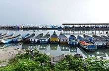
Economy of Koyilandy revolves around fishing, local businesses and remittance from the Persian Gulf.
Around 70% of population follows Hinduism, and around 30% follows Islam in Koyilandy.[2]
Koyilandy taluk
Koyilandy is the taluk headquarters of 34 villages. They are: Arikkulam, Atholy, Avitanallur, Balussery, Chakkittapara, Changaroth, Chemancheri, Chempanode, Chengottukavu, Cheruvannur, Eravattur, Iringal, Kayanna, Keezhariyur, Koorachundu, Koothali, Kottur, Kozhukkallur, Menhaniam, Meppayur, Moodadi, Naduvannur, Nochad, Palery, Panangad, Panthalayani, Payyoli, Perambra, Sivapuram, Thikkodi, Thurayur, Ulliyeri, Unnikulam, Uralloor, Viyyur and Muchukunnu.
Places of interest
- Urupunyakavu Temple, Moodadi (located at the shore of Arabian sea)
- Kollam Parappally makham (dargah) of Tamim-ul Ansari
- Cheriyamangad Kottayil Shree Durga Bhagavathy Temple
- Valiyamangad Sree Kurumba Bhagavathi Temple
- the pulimuttu
- Sree Kidarathil Thalachillon Devi Temple Kanayankode
- Thalachilion Temple Kanayankode
- Valiyakath (masjid and dargah makham) - Beach Road, Koyilandy
- Kollam Sree Pisharikavu Temple - Kollam
- Manayadath Parambil Sree Annapoorneswari Temple - Koyilandy
- Peruvannamuzhi dam (near Kuttiady)
- Craft Village, Iringal
- Payyoli Sreekurumba Bhagavathi Temple
- Muchukunnu Kottayil Kovilakam Temple
- Poyilkavu Sree Durga Bagavathi Temple
- Kanhilassery Lord Siva temple
- Panthalayani Lord Siva temple
- Kappad beach
- Sakthankulangara Devi temple
- Kottakkal Kunhali Marakkar meusium,Kottakkal
- Koyilandy Jumu'ah Mosque
Suburbs of Koyilandy
- Vengalam and Thiruvangoor
- Vettilapara and Chemancheri
- Chengottukavu and Melur
- Anakkulam and Moodadi Toll
- Nandi, Thikkody and Payyoli
- Iringal, Payyoli, Thikkodi and Moodadi
- Viyyur, Panthalayani, Chengottukavu and Chemancherry
- Thurayur, Keezhariyur, Arikkulam and Kozhukkallur
- Atholy, Ulliyeri, Balussery and Naduvannur
- Kottur, Avittanallur, Cheruvannur and Meppayur
- Chakkittappara, Chempanode, Perambra and Kayanna
- Koorachundu, Koothaly, Menhaniam and Eravattur
- Nochad, Palery and Changaroth
- Muchukunnu and Koyilothum Pady
Transportation
- Railway Station - Koyilandy Railway Station, established in 1901
- Nearest Airport- Calicut International Airport, approximately 50 km (31 mi) away and Kannur International Airport, approximately 69 km (43 mi) away.
- Road - Koyilandy is only 25 km (16 mi) from Kozhikode (Calicut). The road from Kozhikode to Koyilandy passes through Nadakkavu, West Hill, Elathur and Vengalam towns. After Pavangad junction, the road passes through villages like Pookkad, Chemencheri, Poyilkavu, Chengottu Kavu and Melur before reaching Koyilandy town. The town of Koyilandy is situated on either side of the National Highway 66.
Road distances
- Payyoly to Meppayur - 11 km (6.8 mi)
- Payyoly to Perambra - 19 km (12 mi)
- Payyoly to Anchampeedika - 13 km (8.1 mi)
- Thiruvangoor to Kappad beach - 3 km (1.9 mi)
- Thiruvangoor to Adivaram - 68 km (42 mi)
- Koyilandy to Thamarasserry - 28 km (17 mi)
- Koyilandi to Mukkam - 43 km (27 mi)
- Koyilandy to Muchukunnu - 5 km (3.1 mi)
Elected representatives
- Vadakara MP - K. Muraleedharan (Indian National Congress-UPA)
- MLA - K. Dasan (CPIM-LDF)
- Koyilandy municipal Chairman- Adv.K.Sathian
Educational institutions
- Thiruvangoor Higher Secondary School, Thiruvangoor
- Government Vocational higher Secondary School(boys), Koyilandy
- Government Girls Higher Secondary School, Koyilandy
- Poilkave Higher Secondary School, Poilkave
- Government Mopla Vocational Higher Secondary School, Koyilandy
- Sayd Abdulrahman Bafakhy Tangal Memorial Government College (S. A. R. B. T. M. Government College, Muchukunnu)
- R. Shankar Memorial Arts and Science College (RSM SNDP Yogam College, Koyilandy)
- Government Industrial Training Institute, Koyilandy
- Ilahiya Arts and Science College, Chengottukavu
- Sri Sankara Sanskrit University, Nambrathkara, Naduvathur (Post Office)
- Malabar Arts and Science College, Moodadi
- Gururdeva College of Advanced Studies
- ICS Secondary School, Koyilandy
- Gov.ITC Kuruvangad
- Sree Vasu devasramam Higher secondary school,Naduvathur
- Gov.Fisheries Residential technical High school,Koyilandy
Hospitals
- Koyilandy Taluk Hospital
- Rakesh Hospital
- Co-operative Hospital
- Aswini Hospital Kollam
- Sarada (National) Hospital
- M. M. Hospital
- Sakalya Ayurveda Hospital
- Minhans Homeopathy, Multi-speciality Clinic
- Gov. Taluk Homeo hospital,Koyilandy
- Gov. Ayurveda Dispensery,Puliyanchery
- CSH Thiruvangoor
References
| Wikimedia Commons has media related to Koyilandy. |
| Wikivoyage has a travel guide for Koyilandy. |
- http://www.censusindia.gov.in/pca/SearchDetails.aspx?Id=672246
- India Census 2011
- "Archived copy". Archived from the original on 12 November 2014. Retrieved 12 November 2014.CS1 maint: archived copy as title (link)
- Falling Rain Genomics, Inc - Koyilandy
- "Census of India 2001: Data from the 2001 Census, including cities, villages and towns (Provisional)". Census Commission of India. Archived from the original on 16 June 2004. Retrieved 1 November 2008.