Geographical zone
The five main latitude regions of Earth's surface comprise geographical zones[1], divided by the major circles of latitude. The differences between them relate to climate. They are as follows:
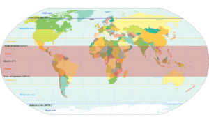
- The North Frigid Zone, between the North Pole at 90° N and the Arctic Circle at 66° 33' N, covers 4.12% of Earth's surface.
- The North Temperate Zone, between the Arctic Circle at 66° 33' N and the Tropic of Cancer at 23° 27' N, covers 25.99% of Earth's surface.
- The Torrid Zone, between the Tropic of Cancer at 23° 27' N and the Tropic of Capricorn at 23° 27' S, covers 39.78% of Earth's surface.
- The South Temperate Zone, between the Tropic of Capricorn at 23° 27' S and the Antarctic Circle at 66° 33' S, covers 25.99% of Earth's surface.
- The South Frigid Zone, from the Antarctic Circle at 66° 33' S and the South Pole at 90° S, covers 4.12% of Earth's surface.
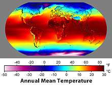
On the basis of latitudinal extent, the globe is divided into three broad heat zones.
Torrid zone
The Torrid is also known as the Tropics. The zone is bounded on the north by the Tropic of Cancer and on the south by the Tropic of Capricorn; these latitudes mark the northern and southern extremes in which the sun seasonally passes directly overhead. This happens annually, but in the region between, the sun passes overhead twice a year.
In the Northern Hemisphere, in the sun's apparent northward migration after the March equinox, it passes overhead once, then after the June solstice, at which time it reaches the Tropic of Cancer, it passes over again on its apparent southward journey. After the September equinox the sun passes into the Southern Hemisphere. It then passes similarly over the southern tropical regions until it reaches the Tropic of Capricorn at the December solstice, and back again as it returns northwards to the Equator.
Temperate zones
In the two temperate zones, consisting of the tepid latitudes, the Sun is never directly overhead, and the climate is mild, generally ranging from warm to cool. The four annual seasons, spring, summer, autumn and winter, occur in these areas. The North Temperate Zone includes Europe, Northern Asia, and North and Central America. The South Temperate Zone includes Southern Australasia, southern South America, and Southern Africa.
Frigid zones
The two frigid zones, or polar regions, experience the midnight sun and the polar night for part of the year - at the edge of the zone there is one day at the winter solstice when the Sun is invisible, and one day at the summer solstice when the sun remains above the horizon for 24 hours. In the center of the zone (the pole) the day is one year long with six months of daylight and six months of night. The frigid zones are the coldest regions of Earth and are generally covered in ice and snow. It receives slanting rays of the sun as this region lies farthest from the equator. Summer season in this region lasts for about 2 to 3 months and there is almost 24 hour sunlight during summer. The sun's rays are always slanting and provides less heat.
History
The concept of a geographical zone was first hypothesized by the ancient Greek scholar Parmenides[2] and lastingly modified by Aristotle.[3] Both philosophers theorized the Earth divided into three types of climatic zones based on their distance from the equator.
Like Parmeneides, thinking that the area near the equator was too hot for habitation, Aristotle dubbed the region around the equator (from 23.5° N to 23.5° S) the "Torrid Zone." Both philosophers reasoned the region from the Arctic Circle to the pole to be permanently frozen. This region, thought uninhabitable, was called the "Frigid Zone." The only area believed to be habitable was the northern "Temperate Zone" (the southern one not having been discovered), lying between the "Frigid Zones" and the "Torrid Zone". However, humans have inhabited almost all climates on Earth, including inside the Arctic Circle.
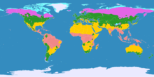
As knowledge of the Earth's geography improved, a second "Temperate Zone" was discovered south of the equator, and a second "Frigid Zone" was discovered around the Antarctic. Although Aristotle's map was oversimplified, the general idea was correct. Today, the most commonly used climate map is the Köppen climate classification, developed by Russian climatologist of German descent and amateur botanist Wladimir Köppen (1846–1940), which divides the world into five major climate regions, based on average annual precipitation, average monthly precipitation, and average monthly temperature.
_no_borders.png)
See also
References
- "The Five Geographical Zones Of The World". WorldAtlas. Retrieved 2019-09-17.
- Strab. 2,2,1-2 in: A. H. Coxon and R. D. McKirahan (eds), The Fragments of Parmenides: A Critical Text With Introduction, and Translation, the Ancient Testimonia and a Commentary, 2nd edn (Phronesis: Supplementary Volumes 3; Assen, Dover (NH), 2009), p. 160.
- Aristotle, Meteorology, Bekker numbers 362a33-362b29