Lower Gangetic plains moist deciduous forests
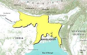
The Lower Gangetic plains moist deciduous forests, or ecoregion IM0120, is a tropical moist deciduous forest ecoregion of Bangladesh and India. The ecoregion covers an area of 254,100 square kilometres (98,100 sq mi), comprising most of Bangladesh and the Indian states of West Bengal, Bihar and Tripura, and extending into adjacent states of Orissa, Uttar Pradesh and a tiny part of Assam.
| Lower Gangetic plains moist deciduous forests ecoregion | |
|---|---|
 | |
 | |
| Ecology | |
| Biome | Tropical moist deciduous forests |
| Borders | List
|
| Bird species | 380+ |
| Mammal species | 126 |
| Geography | |
| Area | 254,100 km2 (98,100 sq mi) |
| Countries | Bangladesh and India |
| Coordinates | 24°02′N 89°53′E |
| Conservation | |
| Conservation status | Critical/Endangered |
| Protected | 2.76% |
Setting
The Lower Gangetic plains moist deciduous forests extends across the alluvial plain of the lower Ganges and Brahmaputra rivers, which form the world's largest river delta. The ecoregion is currently one of the most densely populated regions on earth, and the forests have largely been replaced with intensive agriculture.
The ecoregion is bounded on the east and northeast by montane tropical rain forests; the Mizoram-Manipur-Kachin rain forests covers the Chin Hills and Chittagong Hills to the east, extending into Myanmar and other states of Northeast India, while the Meghalaya subtropical forests covers the Garo-Khasi-Jaintia Hills of Meghalaya and southern Assam, and almost defines the Bangladesh border with Northeast India. To the north, the ecoregion extends to the base of the Himalayas, where it is bounded by the Terai-Duar savanna and grasslands. The upper portion of the Brahmaputra valley in Assam is home to the humid lowland Brahmaputra Valley semi-evergreen forests. To the northwest, the forests are bounded by the Upper Gangetic plains moist deciduous forests. The dry Chota Nagpur dry deciduous forests lie on the Chota Nagpur Plateau to the southwest. The Sundarbans freshwater swamp forests and Sundarbans mangroves ecoregions lie in the swampy, semi-brackish and brackish southern reaches of the Ganges-Brahmaputra Delta bordering the Bay of Bengal.
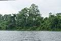
Flora
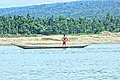
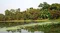
 Seasonal flooding
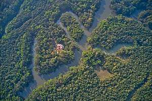
 Inside the forests
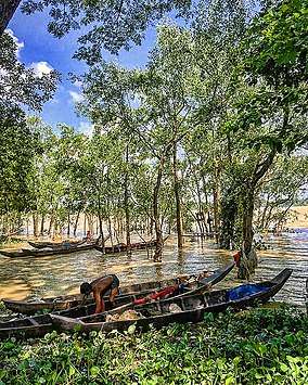
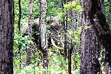
 Endless forest in a flat landscape. Nowadays a rare sight.
Fauna

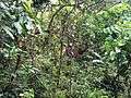
 Where the undergrowth is sparse, monitor lizards can roam.
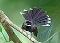 Various bird species (fantail bird)
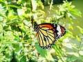 Common tiger butterfliy
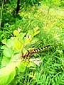 Dragonflies can hunt on the open waters
Conservation
The ecoregion has been densely settled for many centuries, yet much forest remained until the early 20th century. Forest clearance accelerated during the 20th century, and by the end of the century, only 3% of the ecoregion remained in natural forest. Remaining forest areas are mostly small patches, except for one large block of forest south of Varanasi.[1]
In 1997, the World Wildlife Fund identified over 40 protected areas in the ecoregion, with a combined area of about 7010 km², or approximately 3% of the ecoregion's area. Over half of these protected areas were smaller than 100 km²[2]
- Gautam Buddha Wildlife Sanctuary, Bihar (140 km²; also extends into the Chota Nagpur dry deciduous forests)
- Udaipur Wildlife Sanctuary, Bihar (50 km²)
- Kaimur Wildlife Sanctuary, Bihar (2,370 km²)
- Chandra Prabha Wildlife Sanctuary, Uttar Pradesh (80 km²)
- Rajgir Wildlife Sanctuary, Bihar (290 km²)
- Kaimoor Wildlife Sanctuary, Uttar Pradesh (120 km²)
- Valmiki National Park, Bihar (230 km²; also extends into the Himalayan subtropical broadleaf forests)
- Raiganj Wildlife Sanctuary, West Bengal (40 km²)
- Kabartal Bird Sanctuary, Bihar (30 km²)
- Ramsagar National Park, Bangladesh (10 km²)
- Vikramshila Gangetic Dolphin Sanctuary, Bihar 160 km²)
- Nakti Dam Wildlife Sanctuary, Bihar (200 km²)
- Narendrapur Wildlife Sanctuary, West Bengal (90 km²)
- Jaldapara National Park, West Bengal (70 km²)
- Chalan Beel Wildlife Sanctuary, Bangladesh (170 km²)
- Bil Bhatia Wildlife Sanctuary, Bangladesh (30 km²)
- Madhupur National Park, Bangladesh (110 km²)
- Hail Haor Wildlife Sanctuary, Bangladesh (100 km²)
- Roa Wildlife Sanctuary, Tripura (10 km²)
- Bhawal National Park, Bangladesh (90 km²)
- Rema-Kalenga Wildlife Sanctuary, Bangladesh (50 km²)
- Gumti Wildlife Sanctuary, Tripura (420 km²)
- Sepahijala Wildlife Sanctuary, Tripura (20 km²)
- Trishna Wildlife Sanctuary, Tripura (270 km²)
- Aila Beel Wildlife Sanctuary, Bangladesh (30 km²)
- Kawadighi Haor Wildlife Sanctuary, Bangladesh (10 km²)
- Unnamed (20 km²)
- Dakhar Haor Wildlife Sanctuary, Bangladesh (40 km²)
- Dubriar Haor Wildlife Sanctuary, Bangladesh (20 km²)
- Erali Beel Wildlife Sanctuary, Bangladesh (10 km²)
- Hakaluki Haor Wildlife Sanctuary, Bangladesh (160 km²)
- Kawadighi Haor Wildlife Sanctuary, Bangladesh (20 km²)
- Kuri Beel Wildlife Sanctuary, Bangladesh (30 km²)
- Meda Beel Wildlife Sanctuary, Bangladesh (20 km²)
- Rajkandi Wildlife Sanctuary, Bangladesh (50 km²)
- Tangua Haor Wildlife Sanctuary, Bangladesh 160 km²)
- West Bhanugach Wildlife Sanctuary, Bangladesh (50 km²)
- Hazarikhil Wildlife Sanctuary, Bangladesh (30 km²)
- Rampahar-Sitapahar Wildlife Sanctuary, Bangladesh (10 km²)
- Chunati Wildlife Sanctuary, Bangladesh (90 km²)
- Chimbuk Wildlife Sanctuary, Bangladesh (30 km²)
- Himchari National Park, Bangladesh (20 km²)
- Teknaf Wildlife Sanctuary, Bangladesh (100 km²)
- Sangu Matamuhari, Bangladesh (960 km²)
References
- Wikramanayake, E.; Dinerstein, E.; Loucks, C. J.; et al. (2002). Terrestrial Ecoregions of the Indo-Pacific: a Conservation Assessment. Island Press; Washington, DC. pp. 303
- Wikramanayake, E.; Dinerstein, E.; Loucks, C. J.; et al. (2002). Terrestrial Ecoregions of the Indo-Pacific: a Conservation Assessment. Island Press; Washington, DC. pp. 302–304
External links
| Wikimedia Commons has media related to Lower Gangetic plains moist deciduous forests. |
- "Lower Gangetic plains moist deciduous forests". Terrestrial Ecoregions. World Wildlife Fund.
- "Ecoregions 2017". Resolve.
Geographical ecoregion maps and basic info.