Canadian Shield
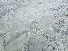
The Canadian Shield or Bouclier canadien (French), also called the Laurentian Plateau, is a large area of exposed Precambrian igneous and high-grade metamorphic rocks (geological shield) that forms the ancient geological core of the North American continent (the North American Craton or Laurentia). Glaciation has left the area only a thin layer of soil, through which the composition of igneous rock resulting from long volcanic history is frequently visible.[3] With a deep, common, joined bedrock region in eastern and central Canada, the Shield stretches north from the Great Lakes to the Arctic Ocean, covering over half of Canada and most of Greenland; it also extends south into the northern reaches of the United States. Human population is sparse and industrial development is minimal,[4] but mining is prevalent.
| Canadian Shield Stratigraphic range: Precambrian | |
|---|---|
| Type | Shield |
| Unit of | North American craton |
| Sub-units | Laurentian Upland Kazan[1] |
| Area | 8 000 000 km2[2] |
| Location | |
| Region | North America |
| Country | |
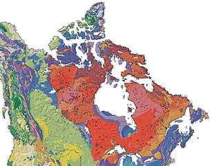 The Canadian Shield is a broad region of Precambrian rock (pictured in shades of red) that encircles Hudson Bay. It spans eastern, northeastern, and east-central Canada and the upper midwestern United States. | |
Geographical extent
The Canadian Shield is a physiographic division comprising four smaller physiographic provinces: the Laurentian Upland, Kazan Region, Davis and James.[1] The shield extends into the United States as the Adirondack Mountains (connected by the Frontenac Axis) and the Superior Upland. The Canadian Shield is a U-shaped subsection of the Laurentia craton signifying the area of greatest glacial impact (scraping down to bare rock) creating the thin soils. The Canadian Shield is more than 3.96 billion years old. The Canadian Shield once had jagged peaks, higher than any of today's mountains, but millions of years of erosion have changed these mountains to rolling hills.[5]
The Canadian Shield is a collage of Archean plates and accreted juvenile arc terranes and sedimentary basins of the Proterozoic Eon that were progressively amalgamated during the interval 2.45–1.24 Ga, with the most substantial growth period occurring during the Trans-Hudson orogeny, between ca. 1.90–1.80 Ga.[6] The Canadian Shield was the first part of North America to be permanently elevated above sea level and has remained almost wholly untouched by successive encroachments of the sea upon the continent. It is the Earth's greatest area of exposed Archean rock. The metamorphic base rocks are mostly from the Precambrian (between 4.5 billion and 540 million years ago) and have been repeatedly uplifted and eroded. Today it consists largely of an area of low relief 300–610 m (980–2,000 ft) above sea level with a few monadnocks and low mountain ranges (including and Laurentian Mountains) probably eroded from the plateau during the Cenozoic Era. During the Pleistocene Epoch, continental ice sheets depressed the land surface (creating Hudson Bay) but also tilted up its northeastern "rim" (the Torngat), scooped out thousands of lake basins, and carried away much of the region's soil. The northeastern portion, however, became tilted up so that, in northern Labrador and Baffin Island, the land rises to more than 1,500 metres (5,000 feet) above sea level.
When the Greenland section is included, the Shield is approximately circular, bounded on the northeast by the northeast edge of Greenland, with Hudson Bay in the middle. It covers much of Greenland, all of Labrador and the Great Northern Peninsula of Newfoundland, most of Quebec north of the St. Lawrence River, much of Ontario including northern sections of the Ontario Peninsula, the Adirondack Mountains[7] of New York, the northernmost part of Lower Michigan and all of Upper Michigan, northern Wisconsin, northeastern Minnesota, the central and northern portions of Manitoba away from Hudson Bay, northern Saskatchewan, a small portion of northeastern Alberta,[8] mainland Northwest Territories to the east of a line extended north from the Saskatchewan-Alberta border, most of Nunavut's mainland and, of its Arctic Archipelago, Baffin Island and significant bands through Somerset, Southampton, Devon and Ellesmere islands.[2] In total, the exposed area of the Shield covers approximately 8,000,000 km2 (3,100,000 sq mi). The true extent of the Shield is greater still and stretches from the Western Cordillera in the west to the Appalachians in the east and as far south as Texas, but these regions are overlaid with much younger rocks and sediment.
Geology
The Canadian Shield is among the oldest on earth, with regions dating from 2.5 to 4.2 billion years.[9] The multitude of rivers and lakes in the entire region is caused by the watersheds of the area being so young and in a state of sorting themselves out with the added effect of post-glacial rebound. The Shield was originally an area of very large, very tall mountains (about 12,000 m or 39,000 ft)[10] with much volcanic activity, but over hundreds of millions of years, the area has been eroded to its current topographic appearance of relatively low relief. It has some of the oldest (extinct) volcanoes on the planet. It has over 150 volcanic belts (now deformed and eroded down to nearly flat plains) whose bedrock ranges from 600 to 1,200 million years old.
Each belt probably grew by the coalescence of accumulations erupted from numerous vents, making the tally of volcanoes reach the hundreds. Many of Canada's major ore deposits are associated with Precambrian volcanoes.
The Sturgeon Lake Caldera in Kenora District, Ontario, is one of the world's best preserved mineralized Neoarchean caldera complexes, which is 2.7 billion years old.[11] The Canadian Shield also contains the Mackenzie dike swarm, which is the largest dike swarm known on Earth.[12]
Mountains have deep roots and float on the denser mantle much like an iceberg at sea. As mountains erode, their roots rise and are eroded in turn. The rocks that now form the surface of the Shield were once far below the Earth's surface.
The high pressures and temperatures at those depths provided ideal conditions for mineralization. Although these mountains are now heavily eroded, many large mountains still exist in Canada's far north called the Arctic Cordillera. This is a vast, deeply dissected mountain range, stretching from northernmost Ellesmere Island to the northernmost tip of Labrador. The range's highest peak is Nunavut's Barbeau Peak at 2,616 metres (8,583 ft) above sea level.[13] Precambrian rock is the major component of the bedrock.
The North American craton is the bedrock forming the heart of the North American continent and the Canadian Shield is the largest exposed part of the craton's bedrock.
The Canadian Shield is part of an ancient continent called Arctica, which was formed about 2.5 billion years ago during the Neoarchean era. It was split into Greenland, Laurentia, Scotland, and Siberia, and is now roughly situated in the Arctic around the current North Pole.
Ecology
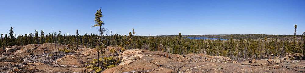
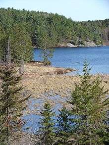
The current surface expression of the Shield is one of very thin soil lying on top of the bedrock, with many bare outcrops. This arrangement was caused by severe glaciation during the ice age, which covered the Shield and scraped the rock clean.
The lowlands of the Canadian Shield have a very dense soil that is not suitable for forestation; it also contains many marshes and bogs (muskegs). The rest of the region has coarse soil that does not retain moisture well and is frozen with permafrost throughout the year. Forests are not as dense in the north.
The Shield is covered in parts by vast boreal forests in the south that support natural ecosystems as well as a major logging industry. The boreal forest area gives way to the Eastern Canadian Shield taiga that covers northern Quebec and most of Labrador. The Midwestern Canadian Shield forests that run westwards from Northwestern Ontario have boreal forests that give way to taiga in the most northerly parts of Manitoba and Saskatchewan. Hydrologic drainage is generally poor, the soil compacting effects of glaciation being one of the many causes. Tundra typically prevails in the northern regions. Many mammals such as caribou, white-tailed deer, moose, wolves, wolverines, weasels, mink, otters, grizzly bear, polar bears and black bears are present.[14] In the case of polar bears (Ursus maritimus), the Shield area contains many of their denning locations, such as the Wapusk National Park.[15]
Mining and economics
The Canadian Shield is one of the world's richest areas in terms of mineral ores. It is filled with substantial deposits of nickel, gold, silver, and copper. Throughout the Shield there are many mining towns extracting these minerals. The largest, and one of the best known, is Sudbury, Ontario. Sudbury is an exception to the normal process of forming minerals in the Shield since the Sudbury Basin is an ancient meteorite impact crater. Ejecta from the meteorite impact was found in the Rove Formation in May 2007. The nearby but less-known Temagami Magnetic Anomaly has striking similarities to the Sudbury Basin. This suggests it could be a second metal-rich impact crater.[16]
In northeastern Quebec, the giant Manicouagan Reservoir is the site of an extensive hydroelectric project (Manic-cinq, or Manic-5). This is one of the largest-known meteorite impact craters on Earth.
The Flin Flon greenstone belt in central Manitoba and east-central Saskatchewan "is one of the largest Paleoproterozoic volcanic-hosted massive sulfide (VMS) districts in the world, containing 27 copper-zinc-(gold) deposits from which more than 183 million tonnes of sulfide have been mined."[17]
The Shield, particularly the portion in the Northwest Territories, has recently been the site of several major diamond discoveries. The kimberlite pipes in which the diamonds are found are closely associated with cratons, which provide the deep lithospheric mantle required to stabilize diamond as a mineral. The kimberlite eruptions then bring the diamonds from over 150 kilometres (93 mi) depth to the surface. The Ekati and Diavik mines are actively mining kimberlite diamonds.
See also
References
- The Atlas of Canada. "Physiographic Regions Map". Natural Resources Canada. Retrieved 2019-11-15.
- Encyclopædia Britannica. "Canadian Shield". Archived from the original on 2015-06-24. Retrieved 2009-02-10.
- Stephen Marshak. Essentials of Geology. 3rd ed.
- "Canadian Shield Archived 2006-08-21 at the Wayback Machine" in Columbia Encyclopedia. 6th ed., 2005.
- James-Abra, Erin. "Canadian Shield". Canadian Encyclopedia. Archived from the original on 11 January 2018. Retrieved 24 January 2018.
- Corrigan, D. (2008). "Metallogeny and Tectonic Evolution of the Trans-Hudson Orogen" (PDF). Archived from the original (PDF) on April 9, 2008. Retrieved 2008-03-05. Cite journal requires
|journal=(help) - Peterson Field Guide to Geology of Eastern North America by Roberts, David & Roger Tory Peterson.
- Alberta Heritage - Alberta Online Encyclopedia Archived 2010-12-08 at Archive-It - The Canadian Shield Region of Alberta
- Tsuyoshi Iizuka, at al., Geology and Zircon Geochronology of the Acasta Gneiss Complex, Precambrian Research, 153 (2007) pp. 179 - 208
- Clark, Bruce W. (1999). "Geologic History". Making Connections: Canada's geography. Scarborough, Ontario: Prentice Hall Ginn Canada. pp. 95. ISBN 978-0-13-012635-1.
- Caldera Volcanoes Archived 2012-08-14 at the Wayback Machine Retrieved on 2007-07-20
- Pilkington, Mark; Roest, Walter R. (1998). "Removing varying directional trends in aeromagnetic data". Geophysics. 63 (2): 446–453. Bibcode:1998Geop...63..446P. doi:10.1190/1.1444345.
- "Barbeau Peak". Bivouac.com.
- World Wildlife Fund, ed. (2001). "Northern Canadian Shield taiga". WildWorld Ecoregion Profile. National Geographic Society. Archived from the original on 2010-03-08.
- C. Michael Hogan (2008) Polar Bear: Ursus maritimus, Globaltwitcher.com, ed. Nicklas Stromberg Archived December 24, 2008, at the Wayback Machine
- 3-D Magnetic Imaging using Conjugate Gradients: Temagami anomaly Archived 2009-07-11 at the Wayback Machine Retrieved on 2008-03-12
- Troymet Exploration, Report on the 2007 Diamond Drilling Program, McClarty Lake Project, Manitoba: The Pas Mining District NTS 63-K-08; UTM ZONE 14 N 415938 E, 6038968 N; 54° 29′ 28″ N 100° 17′ 52″ W, by Jessica Norris & Tracy Hurley (Whitehorse, Yukon: Aurora Geosciences, 2007‑09‑24).
Further reading
| Library resources about Canadian Shield |
- Schwartzenberger, Tina (2005), The Canadian Shield, Weigl Educational ISBN 1-55388-141-9
| History |
| ||||
|---|---|---|---|---|---|
| Provinces and territories |
| ||||
| Government | |||||
| Politics | |||||
| Geography |
| ||||
| Economy | |||||
| Society | |||||
| Demographics |
| ||||
| Culture | |||||
| Symbols | |||||
| Article overviews | |||||
| Research | |||||
| |||||
| Authority control |
|
|---|